

(1924-1991)
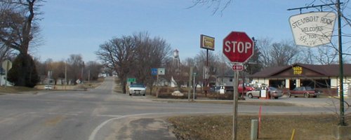
NORTH End: 4-way stop, D35/Main St., Steamboat Rock, Hardin County
Facing north on 118
LGS in above picture (by white car), on S56
Hardin County, like other counties, occasionally has signs just after the intersection that would normally/should appear before it.

Facing south on 118
About half of the route is in Pine Lake State Park (see entrance picture below).

Facing south on 118
RAGBRAI riders went from Iowa Falls to Marshalltown in 2004, traveling the length of 118.
SOUTH End: Stop sign, IA 175, near Eldora, Hardin County

Facing south on 118

Facing east on 175
The arrow under the Greenbelt sign must have fallen off or been removed; you can make out the outline.

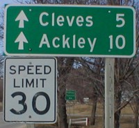
LGS at bottom of above picture
The sign for entering Eldora is on the far left. Although only 4 miles away from Eldora, Steamboat Rock is a part of the Ackley-Geneva-Wellsburg-Steamboat Rock school district, formed in 1999 after a controversial merger process.

Facing west on 175
Coming into Eldora from the west, there is a very pretty view of the Iowa River valley.

Facing west on 175

Facing north on 118
Immediately after you turn onto 118, you enter Pine Lake State Park. Pine Lake was created as part of a CCC project in the 1930s. Compare the plaque at right to the picture below:

Facing north on 118
RAGBRAI riders prepare to turn westward into Eldora in July 2004.

Facing west on 175
I'll let this picture speak for itself.
Last seen: 1991 (1986 map)

All pictures by me: First-third, seventh, and tenth, 3/23/02; fourth, sixth, eighth, ninth, eleventh, and twelfth, 7/28/04; fifth, 4/4/06
Page created 5/7/02; last edited 5/14/06
