

(July 1, 1920-August 14, 1984)
NORTH End: Intersection, IA 150, Benton County

Facing north on 101
This pole is the most likely candidate for the "End 101" sign. Most likely, 150 NB (WB) stopped, while north-south traffic was unimpeded; traffic continuing on northbound 150 could use the small curve and meet a yield sign.
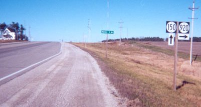
Facing north on 101
Photo by Jason Hancock
Before 150 was rerouted, this was the posted north end of 101. Highway 920 follows 150's old route to Center Point. LGS says "Walker 5 ->".
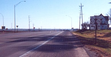
Facing south on 150
Photo by Jason Hancock
Continuing south would put you on 101, while turning left would continue on 150. This could explain the up-and-left arrow under the 920, as a leftover from 150's turn; the arrow has since been removed.

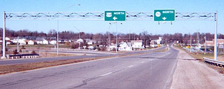
Facing west, but heading north, on 150
Turn left for 101, follow the curve to continue on 150.
SOUTH End: Direct merge into US 218, Vinton, Benton County

Facing south on 101
Before approximately 1960, the intersection with 218 was in downtown, probably C Avenue and Fourth Street. This intersection would have been 101's south end for 24 years.

Facing south on 101
In its non-Avenue-of-the-Saints segment between Cedar Rapids and Waterloo, 218 only crosses the city limits of two other incorporated towns (Vinton and La Porte City).

Facing south on 101

Facing north on 218

Facing north on 218
Same signs, view of 218 curve
Photo by Jason Hancock


Facing east, but heading south, on 218

Facing east, but heading south, on 218
There used to be a sign on the gantry that spelled out "Curve Speed 35."

Facing east, but heading south, on 218
Last seen: 1984 (1981 map)

Pictures by Jason Hancock: Second, third, and tenth, 12/9/01
Pictures by me: First and fourth, 5/20/03; fifth-ninth and eleventh-fourteenth, 3/12/07
Page created 2/25/02; last updated 4/30/07
