
Linda and I left Wai`anae under cloudy skies and a little rain. It rained all night long here in Wai`anae and we really wondered if the hike would be on or not. As we drove Honolulu bound on Farrington Highway we noticed clear skies ahead.
Rounding Barber’s Point the Ko`olau summit was buried in clouds and as we got closer to Pearl City we got some rain. As we drove up Kaonohi it seemed a bit dryer. Turning on to Onikiniki, a little after 8 a.m; we saw the gang slinging on backpack and getting ready to work. Not many people were in rain gear. Linda and I donned our pack and I put on my rain jacket as it was drizzling.
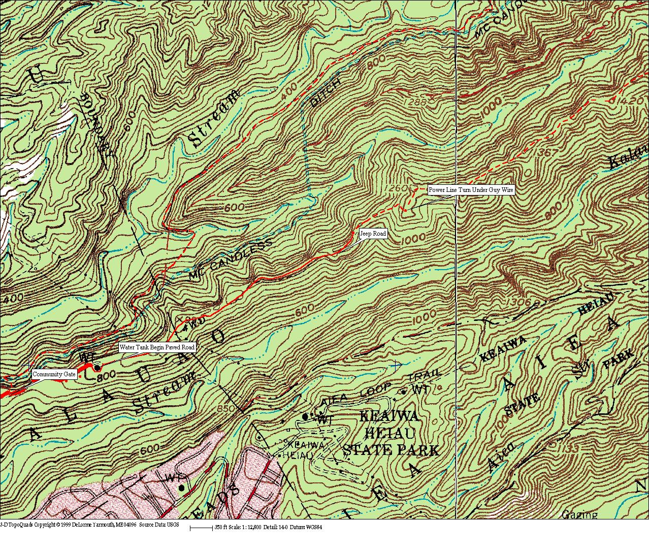
We started down the trail and noticed John Hall cutting steps into the steep hillside. Going was slow as we inched our way past cut water hoses which once were long and tied to trees. About a year and a half I had added about 4 ropes to the water hoses so going up and down the steep hillside was not to much work. Unfortunately some idiots took my ropes and cut the water hoses so short that they were useless.
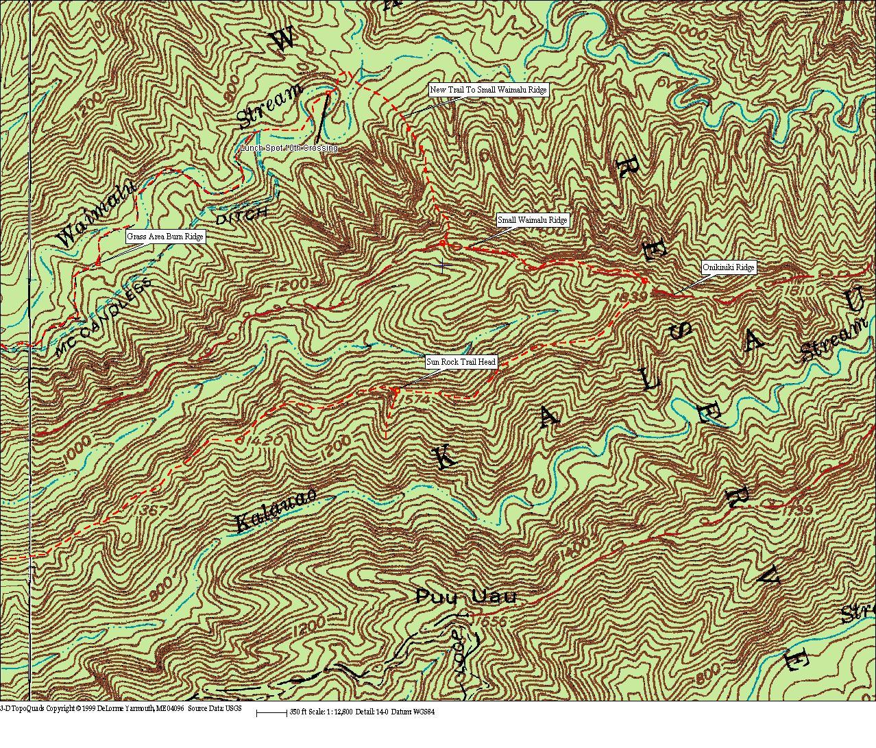
As usual Dayle, Peter and Ed were out in front with nothing on the relatively flat ditch trail to slow them down. Linda and I stayed pretty much together for a while. Somewhere after the caves she pulled ahead and I worked by myself cutting here and there. Behind me were Tom, Kenji and Grant. I caught up with Linda along the trail as it cuts down from the level ditch to cross Small Waimalu Stream. The water flow was not much, but there was a lovely waterfall and pool below the crossing.
Climbing the other bank of the stream the trail winds around the nose of Small Waimalu Ridge and then enters a Hala forest. The trail was pretty much open and not a lot of cutting was needed. Then low and behold we caught up with the advance team as they hacked at Hau branches covering the trail. We five stayed together until we reached the end of the level trail at the open grass area (time 1040 am) where years ago there had been a fire. It’s amazing how the native Koa and Naupaka have grown back in this region. Of course I have no idea what was there before the fire.
Earlier along the trail I spotted a nice small palm with red roots. I had left my camera home and so I radioed back to Tom asking him to take some photos for me. Thanks Tom they look good and as of yet I don’t know what palm it is. I linked the pictures to the International Palm Society web page and hope to have an answer in a few days. The palm was identified as most likely Pinanga coronata v.kuhlii by Ray Baker of the Lyon Arboretum. He said seeds most likely spread by birds.
Linda, Dayle and myself snacked there; Peter and Ed keep going down to the river. A few minutes behind us came Tom and Kenji and Jason. After a short break we climbed down to the riverbank. There was a lot more water flowing here and as I entered the water to cross I soon found it up to my waist. The current was not strong and we all made it across without mishap. Linda chuckled out loud as each of the guys you know what met the cold water and we each howled a bit.
There were about 9 more crossings till we reached out destination and lunch spot. Much hau had to be cut. We left behind a nice open trail. After the first deep crossing the rest were not much more than knee deep. At one point when Mabel radioed and asked how things were Tom said the first crossing was about waist high. I quickly returned that for Mabel, Carol, and June it would be a lot higher but below their necks.
We ate lunch at 12:30 sitting on a log in a light drizzle. Discussion wandered but kept coming back to Dayle wanting to climb a ridge to Small Waimalu ridge and then hiking up that trail to Onikiniki ridge and going down along that wide open trail. About 1 pm we rose from lunch and divided into two groups. Dayle, Ed and I would look for the ridge Dayle picked on his map while Linda, Peter and Tom went back along the river. They were the smart ones.
The three crazy guys crossed the river at the lunch spot and then climbed the opposite bank high over a small ridge. Going down the other side and a short walk took us to the confluence of Waimalu River’s left and right tributaries. We cross below the confluence heading very slight up the right hand stream. In a few minutes Professor Dayle with his now famous Hawaiian DNA trail finding genes working found “his” ridge. Up thru the Uluhi we climbed and climbed and climbed. Dayle and Ed seemed not to be working as hard as I. We left the riverbank at an elevation of about 500 feet about 1:15 and topped out on Small Waimalu ridge at an elevation of about 1500 feet. I caught up with the two when they took extended breaks. But they always blasted out ahead of me again. At 2:25 I again caught up as they rested on Small Waimalu’s crest.
I led the way for a while as we went up and down small pu`us on the ridge. Finally not wanting to slow Dayle and Ed down anymore I let them pass. There are about 3 false summits and before hitting Onikiniki ridge and just below each one I was sure I was finished with the ridge. At 3:00 pm I finally reached Onikiniki where I talk a short break and ate a power bar. At this point I figured Ed and Dayle 15 to 20 minutes ahead of me.
The walk down was uneventful. The trail is wide and for the most part either down or on level ground. There are some ups but they are minor even considering the climb up from the river. I reached the first power line at 4 pm and kept going straight down the ridge. Suddenly I found there was no trail! How do you loose a trail that is 2 feet wide? In looking around for the trail I could see that I was on a “ridgeline” which made sense, but where was the trail? So I scouted to the right and still no trail. I cut up back toward the power towers and thru a small guava patch. Then all of a sudden there it was, wider than ever. It seems that as you pass the first set of power poles you have to turn right ninety degrees as the “main” ridge takes a sharp turn there.
After passing the second set of power poles the jeep road began. Walking became even easier. I rather like hiking alone, stopping now and then to enjoy the beauty of nature. At 4:30 I reached the water tank and the beginning, or end depending on your direction, of the paved road. Down through the houses I walked my steel cleats click clacking down the pavement and around 4:45 I reached the gate and the party below.
As usual the food was great and the stories being told were either funny or informative. Another great day, despite the light showers, with great friends.
Here is a link to Tom’s pictures. I believe he had the only camera on the hike. I don’t like to carry mine on rainy days as it’s a bit bulky.
http://www.ofoto.com/I.jsp?m=63197926303&n=697888582
Below are two detailed maps showing the trails.
Wai`anae Steve
