
Namhan Sansong (Southern Mountain Fortress)
Overall difficulty level: 7/10
Skill: 5/10 (Spongepack), 6/10 (Halftrack), 7/10 (Big Mac Attack), 5/10 (Honeybee), 8/10 (The Nose), 6/10 (Butt Crack), 7/10 (Rim Job), 10/10 (Hummer), 6/10 (Lickety Split), 5/10 (Sesame Street), 5/10 (Crushed Penis), 5/10 (Full Monty uphill), 5/10 (Rake Me), 10/10 (Queen Bee), 5/10 (Bee-Gee), 8/10 (The Valley of Death), 5/10 (unnamed, past Rake Me), ?/10 (unridden, Songnam trail), 1/10 (paved uphills)
Aerobic: 4/10 to 9/10 (depending on routing)
Scenic: 9/10
Crowdedness: 2/10
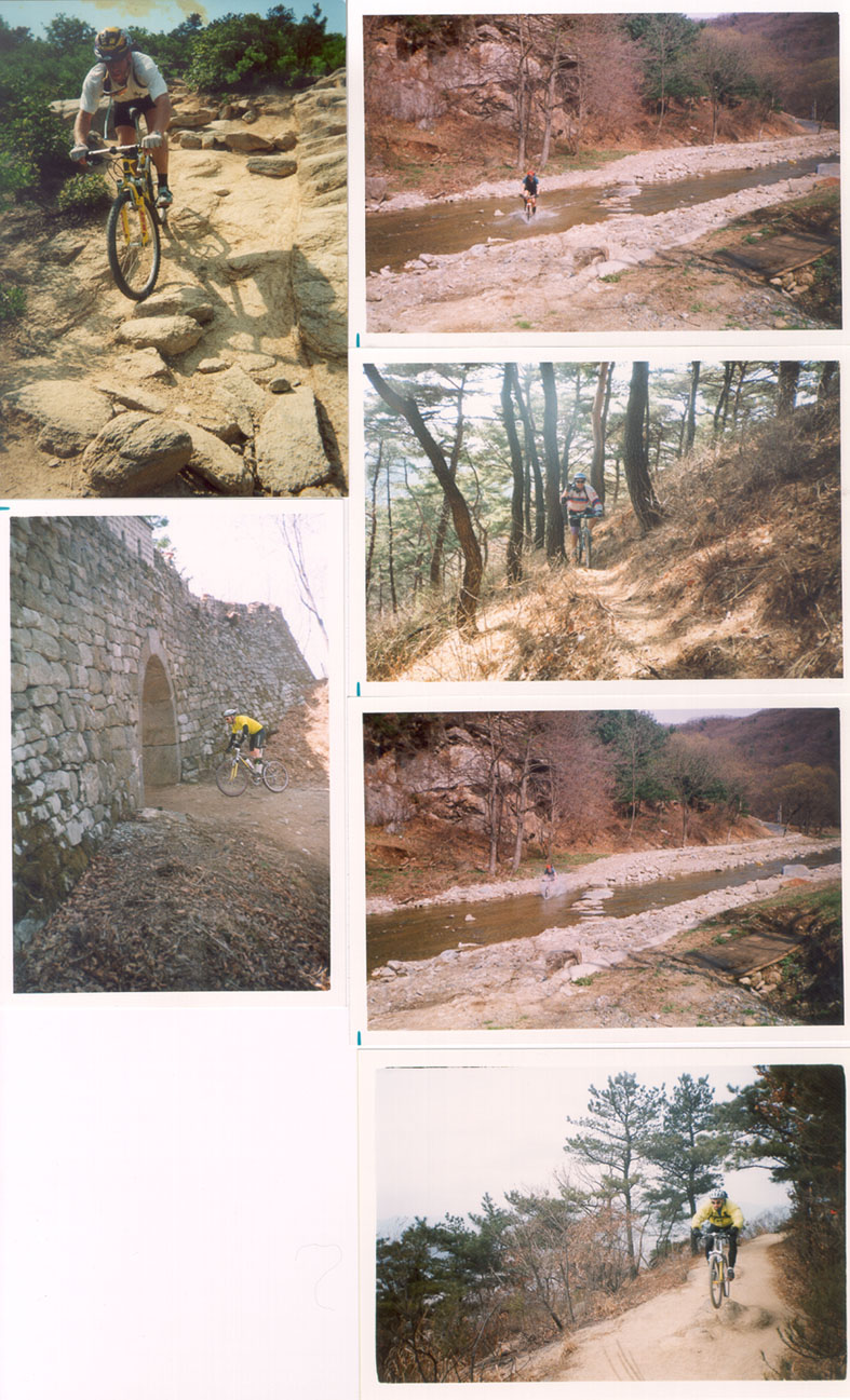
Namhan Sansong is a new "discovery" for mountain bikes and is currently (12/99) my preferred riding area. It's very beautiful, with a continuous ancient wall capping ridges that surround a small mountain bowl at over 500 meters elevation, and long views out to Seoul to the northwest. Everyone knows the Great Wall (as in, of China); you might be forgiven if you call this one the Minor Wall of Korea. Despite the car parks inside the fortress, the wall itself is nice, with an access trail following the outside base of the wall (although it doesn't go all the way around). Best of all, once you're on the singletrack descents, you won't find many other hikers on the weekend; they're all inside the fortress with their cars, waiting in traffic jams to get up the mountain and then waiting in traffic jams to get back down. Ha!
As for the riding, it's got gentle, paved uphills and at least 16 singletrack descents off of 4 main 5 km ridges (Honeybee, Big Mac, Half Track and Spongepack) plus the fortress area itself (Rim Job, Hummer, Queen Bee) that has the steeps -- descending straight down from the wall at 500m to near sea level in 2km or less. Halftrack heads east, to the satellite city of Kwangju. It's a slalom rider's dream: very narrow and at times quite steep. Shin pads and some sort of arm covering are good ideas, because you will get bushwhacked. It's not very rideable once Spring is in bloom. Spongepack is the easiest, but puts you the farthest away from civilization. It heads south to a road that runs between Kwangju and another satellite city, Songnam. It's your standard singletrack romp, not too difficult, but to get back to Namhan Sansong or Songnam, you're going to have to ride for quite a while on a road. You can take an earlier keft-turn detour onto Rake Me that puts you on the eastern paved climb into park. Big Mac Attack heads northwest to within legshot of the Olympic Park in Seoul. After some intimidating steep rocky business at the top, it screams downhill, complete with berms, ruts, tight corners, dropoffs -- all on an amazing series of ridges which at times allow you to think that you're flying, which you might do in places if you go off-trail. Our newest find is Honeybee, perhaps the best of the bunch: about 5km of totally 100% rideable swooping singletrack heading only downhill. It ends in Hannam. There are other trails we've found and others we have to finish exploring.
Access: Namhan Sansong is a regional park to the south of Seoul, between the satellite cities of Songnam, Kwangju and Hannam. Only Songnam is connected to Seoul by subway. The Sansong subway stop (line 8), is already at a little elevation; careful, this station is suspiciously missing from most subway system maps (don't confuse it with Namhan Sansong subway station). From exit 1, just follow the big highway-like road uphill for about 0.5 km and make a left onto the two-lane paved road that goes into the park itself. This is the park's western entrance. Ride uphill for 3.2km to a tunnel. Don't go in the tunnel; instead turn right and continue 50 meters or so to the fortress's South Gate (Nam Moon). This park road actually continues through the fortress itself at the top, and descends east for about 8km on the other side, finally ending near Kwangju, where the eastern park entrance lies. At any of the ticket booths (don't pay -- you're on a bike!) you can pick up a free map showing some of the initial access trails and historical sites within the walls. It's not perfect, but it'll do in a pinch. Your main orientation point are the single rotary in the middle of the fortress, where the eastern and western paved climbs finish. Also, there are the four gates: South Gate (nam moon), West (saw moon), North (pook moon) and East (tong moon). Trails begin from all except East Gate, which lies on the eastern paved climb.
Suggested coursing: Since I originally wrote this section in 4/99, we've gotten to know the area pretty well. For first-timers to Namhan Sansong, I strongly recommend doing Honeybee first. From the rotary, which everyone knows, head north 500m or so to the North Gate, which at the time of this writing remains locked. If you could go straight, you'd be on Valley of Death and/or Rim Job and another trail that connects the two. Anyway, we aren't going there today. Turn right, heading east and follow the inside of the wall about 2km til you get to a mountain spring. There are a few trails here, but the dominant trail continues east and rises steeply up through the trees. We held an uphill "race" here based on elevation gained while riding. Fun. No-one's climbed all 600m of it yet, although a few have come close. If you do, send me your name and I'll post it here. Ha! Anyway, at the top, turn left and after 100 or 200m you'll come to an archway. Go thorugh it and turn right. You're now on a singletrack at the outside base of the wall. 50m ahead of you is another archway. Continue through it. This might be a good place to lower your saddle, if you're a saddle-lowerin' king of guy or gal like me. Continue straight through a steep drop-in. The trail will ease uphill slightly and then you'll come to a fork. To the right is uphill and takes you to Half Track and Butt Crack. We're going left, which takes you to Honeybee, Full Monty uphill, Sesame Street, and most alarmingly, Queen Bee, which is just stoopid steep (I've lost more than my pride on that trail--I'velost bike parts.). Anyway, if you're actually riding Queen Bee, you probably are very plugged into the Korean riding scene and don't need this description. Anyway, onwards. After the aforementioned fork, you'll come upon the 3rd and last archway. Honeybee is right through it; Queenbee is just to the left of the arch. Going down Honeybee, I can't really tell you exactly how to stay on the correct trail. Just follow your nose down the main ridge. After 3km or so you'll come across the last of many forks. This one has an orange plastic stake in the ground. The left is the beginning of Sesame Street. The right is the original Honeybee. Sesame St is better. Take it. You'll have to negotiate some serious series of switchbacks on Sesame Street. Ssssss. Just follow it out to the road. Classic. Fun fast or slow. From here, Hannam City, you can ride 40 minutes back to Olympic Park in Seoul (down the valley and turn left), or you can go up the Full Monty, which starts as a dirt road to your right and then becomes steep uphill singletrack. Climb your heart out and descend on the other side of the peak. At the four-way trail intersection, you can go left or right. Don't go straight. Left is Penis Crush. Right is the Full Monty descent, which is actually doubletrack. Take the doubletrack down to another valley and ride the paved road out of the valley and onto the highway. Turn right and after 3km or so of level-to-uphill traffic riding, you'll come to the park's eastern entrance on your right. Sit back and enjoy the climb after passing through the entrance. This road goes back to the rotary. Alternately, you can climb up Honeybee: when climbing Full Monty, after the dirt road finishes and you've got in a flat clearing and you've got trails in 3 directions, make a right onto a steep uphill unrideable singletrack chute. This will carry you back to Honeybee. If you've got low enough gearing, you can climb about 2/3 of Honeybee. 5km/50 minutes to access and descend Honeybee and Sesame St. 25km/100 minutes to do the round trip.
Alternate coursing #1: I like to start at the western entrance, go through the fortress wall to Halftrack (which begins exactly at the extreme northeast end of the wall (not close at all to East Gate (Tong Moon)), and which may be difficult to find. The trail begins steeply from the top of a crumbling part of the wall itself! After a few minutes or 10, take a well-used singletrack on the left. You'll know you missed the turn-off if you arrive at a traditional grave instead. After 10 or 30 minutes (?) you'll come to a 50m or so walk-up. Ride down, following the trail until you get to a singletrack T-intersection and another walk-up. The trail to your right goes to a stone cottage and a farm. You could walk up and ride down the other side (45 - 50 degrees!) but don't do like Brett and impale the palm of your hand on Easter (True story). Make a left on the paved country road (You're now in Omiri Valley) and ride for 5 minutes until you hit a highway. Turn right, and ride slightly downhill for about 2 km (?) until you see the other entrance to the park on your right; this is the paved uphill I described above, about 8 km long. It will take you up to the East Gate (Tong Moon). Along the way, you can stop for food if you want. Laugh at the hikers stuck in traffic jams as you pass them on your bike, going 10 kph. After that edutainment, find your way to the West Gate (Seo Moon), which is actually in the nothwest part of the fortress. Ride dramatically through the gate (the only way to ride through that gate! If you time it for sunrise, the sun is perfectly framed by the gate. Spectacular!), make a sharp right and ride the trail that follows the outside of the wall. This part is very beautiful, and is a good place to rest. Ride for about 200 meters and look for a small modern watchtower on your left. When you spot it, you're facing north and Seoul lies in front of you in the distance. I called this Big Mac Attack, because it's a downhiller's delight (and, like western men throughout history, we have an odd tendency to name things in foreign lands that we come across). Anyway, take this trail to the watchtower, where there are more views. There are some steep, rocky sections here at the tower which may lead you to think the trail's unrideable. Just downclimb and ride along the obvious ridge. It's a classic Korean trail. After 20 or 30 minutes (I forgot), you can turn left on a well-used but easily unnoticed trail that descends steeply for a few minutes to the western side of Hannam, with Olympic Park (in Seoul) being about a 15 minute ride away, and the Han River Park just beyond. The best way to describe how to find the turn-off is this: after about 100 or 200 meters past the left turn, the trail starts going uphill and at the top becomes unrideable again. Or, you can ride beyond this turn-off, putting you farther out, in eastern Hannam. Just follow the obvious ridge all the way to the terminus. You can't go wrong with any left-turn fork in the trail you come to. All trails are good, and all end in roughly the same area. About 27km/4 hours.
Alternate coursing #2: I haven't even talked about Spongepack, the southerly trail. From the South Gate (Nam Moon), there is an obvious uphill trail next to the outside part of the fortress wall. Take it and continue until it goes back down a little and hits another paved road. This road won't have traffic, as it's a military road that actually takes you away from the fortress and to the next mountain to the south. At the top is a military base, about 2 km away. Just shy of the base's parking lot, there is a little dirt area on the left side of the road, with a gravel road going uphill to a little lookout some 50 meters away, some kind of tank parking space or something, and Spongepack going downhill. Heading on this trail, you'll be going up and down for 10 - 20 minutes, and there will be many turn-offs. Just stay on the dominant trail and don't make any sharp turns off of it. Eventually you'll end up on a rough dirt road. Turn right and go downhill for a minute or two. Right before an imposing climb, look left. There should be a hidden little gem of a singletrack going down. Take it all the way down to the bottom, through a farm and follow your nose to a two-lane road that connects Songnam and Kwangju/Hannam. Kwangju is downhill but far, and Songnam is uphill and far. If you go towards Kwangju, turn left on to a highway, heading north, and continue for about 30 minutes (?) to Namhan Sansong's western entrance I described above. Including this route will add about 2 hours to your ride. From the South Gate to the end of the singletrack takes about 5km/50 minutes.
Alternate coursing #3: For those who really like to ride free, may suggest a plate of Hummer. Find West Gate, go through it, immediately turning left on the other side. Lower your saddle all the way. Follow this narrow track around the base of the wall until it abruptly turns right and heads straight down at an obscene angle. It's slippery back in here almost all the time, and the unavoidable rocks and ledges don't help. You'll come to a three-way trail intersection. Straight is a live firing range and barbed wire and a warning in Korean not to go that way. You could go that way -- it's a good trail -- but we haven't fully explored it yet. Later. For now, turn right, heading straight downhill still. More steeps, more rocks. You'll emerge in a small clearing and then must go uhill to your right for a few meters to a mountain spring. Fill up and then continue on past, up and down, some rideable, some not. At the top of a roped climb (meaning you can pull you and yourself up by rope b/c you aren't going to ride up), you'll see a crazy steep on the other side. No rope here, just a staircase that's not fun to ride down and a woods trail that is. This thing is so steep that when you first come up to it, you can't see the bottom on the other side. Past 45%, and to make it more fun, they dug 2 or 3 blind ditches at the bottom, when you're going to fast to stop. I found out the hard way you can hit/jump them. This puts you on, off all places, a Hoola-Hoop training ground. Pick up some hoops and do some cross-training while you wait for your disemboweled riding pardners to show up. Anyway, when you've had enough hoola-hooping, continue straight through. Note the hikers clapping as you ride out of there, if they weren't already cheering after you arrived off the crazy hill. Strange, huh? Continue straight through some spincter-pucker rock gardens for 800m or so and on out to civilization. You are within 20minutes of Olympic Park now, but I don't know exactly how to get there. I always have to ask. Head northwest to get deeper into Seoul. Good luck. 4km/40 minutes.
Additional notes:
--Steve Danyo
