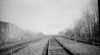
A look back at the New York Westchester & Boston RR and the successor operation of the IRT Dyre Ave Subway Line of the New York City Transit System.
The reason that there was a NYW&B station at Dyre Ave and 233rd St was that there was a trolley line on Dyre Ave which ran from Mt Vernon to a landing on the Hutchinson River.
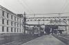
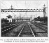
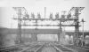
The NYW&B opened on May 29, 1912 as a subsidiary of the New York New Haven & Hartford RR and it operated as a 11,000v AC Electric Railway. The line operated with 70' steel Mutliple Unit (MU) passenger cars supplied by the Stillwell Co.
NYW&B Operations ceased on January 31, 1938.
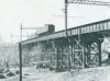
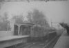
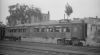
The New York City Transit System purchased the ROW from 174th St to the City limits and began operating the Dyre Ave Line from the 180th St Terminal on May 15, 1941. The two track Dyre Ave Line was equipped with standard subway overruning covered 600v DC third rail. The original equipment was NY Elevated Gate cars equipped with subway third rail shoes. The line retained the 11,000v AC catenary over the two express tracks for a couple of years in the event that the Westchester RR began operation again. There was no thru train service between the IRT White Plains Road Line and the Dyre Ave line until 1957. The terminals at 180th St and Dyre Ave were operated as single track turn-backs. The El cars were replaced by IRT subway cars.
On May 4, 1957, the Dyre Ave Line was connected to the rest of the IRT West Farms Line via a flying junction at Unionport Road so that Dyre Ave Trains used the East 180 St Station instead of the former NYW&B RR Station.
The Dyre Ave Line started Route 2 Seventh Ave Express train through service between the Dyre Ave Terminal in The Bronx and the New Lots Ave Terminal in Brooklyn.
IRT Route 9 Dyre Ave Locals operated to/from the East 180 St Station instead of the former NYW&B terminal.
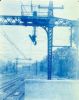
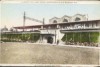
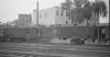
North Ave Station remains
The North Ave station in New Rochelle was on the Port Chester Line
Comments
(1) |
Add a Comment
I lived at 1 Beaufort Place, a few blocks north of this point, until I was 5, in 1950. By the time I had awareness, the fill west of this immense remnant was gone and the area flattened for temporary barracks-type housing for returning GIs from WWII. The concrete hulk of the station and the tower remained until c. 1960 when they were removed for Memorial Highway. The eastern fill was removed in 1956 or 1957 when the New England Thruway opened; access from the Thruway to North Avenue was by a four-lane divided road on the surface that came to a T intersection at North Avenue, with this sad trashed hulk of the station, which was beneath the tracks, the first thing one saw coming into town.
Paul Payton |
bsandpp@verizon.net |
October 19, 2013


