![]()
Three Witnesses
And
The Pyramid Of Giza
In addition to Beth Shemesh the Scriptures and John Strong's Hebrew Lexicon also refer to Ir Shemesh and to En Shemesh as witnesses. Thus, there are actually three witnesses attesting to the location of GOD'S Holy Arks.
Ir Shemesh (Strong's Hebrew Lexicon #5905), in turn, refers to #8121 (Shemesh) and to #5829 (Ir) meaning a city (a place guarded by waking or a watch) in the widest sense (even of a mere encampment or post), etc. Ir then refers to #5782 which gives instructions to open the eyes, to wake, awaken, etc. [Now see Brian's House: SCAM #5 which attests that the Solomonic Temple site West of the Valley of Ben Hinnom (Jeremiah 19:2 KJV) has indeed been well guarded in the widest sense]. Ir Shemesh, of course, refers to the second witness ... the Altar before the Solomonic Temple.
Next, En Shemesh (#5885) meaning fountain of the sun, in turn, refers to #8121 (Shemesh) and #5869 (En) meaning an eye or fountain as the eye of the landscape. And a fountain represents an abundance of water and the sun which bathes the earth in light arises in the East. So, let's consider #5869 as it refers to a fountain (as the eye of the landscape).
Just where is this all-seeing eye?
The answer should be obvious: an eye has been portrayed on the US dollar bill, for example, as being the all-seeing eye surveying the world, the eye replacing the capstone of the great pyramid of Giza.
So, we have three witnesses: Beth Shemesh, Ir Shemesh, and En Shemesh. All three are linked together as a great triangle whose angles are called altars, boundstones, pillars, and witnesses which mark the corners or angles. Shemesh, of course, links each to the Solomonic Temple (the battlement in the East). Now, we have the all-seeing eye that ties events to the pyramid of Giza with its missing capstones. Note: There would be many capstones as the empty platform atop Giza would require many stones before the chief capstone could be mounted in place.
But back to our triangle. Where would one place the apex of the triangle? And, how big is this triangle linking the three witnesses?
Let's examine the ruins of Beth Zur meaning the house of the rock (#1049) which directs us to #1004 (Beth) and #6697 (Zur) which speaks of a cliff (a high) rock, a compressed rock, a sharp rock (such as a capstone that has four sharp edges that come to a point). From here we are referred to #6696 meaning to cramp, i.e.confine in many applications. And the rock at Beth Zur is a tall narrow compressed obelisk. Also, the compressed and confined are the opposite of stretch out and expand.
Now the ruins of Beth Zur are just North of Hebron. But when examining different maps, Beth Zur was plotted in slightly different locations on each. Therefore, Beth Zur's ruins were not too dependable a place to start.
In the 1850's and 60's John Taylor and Charles Piazzi Smyth made some rather interesting observations regarding the great pyramid of Giza. That is, the perimeter of the square base (4B) equals the circumference of a circle (2 pi r) whose radius (r) equals the altitude of the pyramid if the chief capstone were in place. And since we know that pi approaches 22/7 or 3.14 then:
| r = | 2B 3.14 |
So, if a baseline (B) were known then the altitude or distance (r) from the base to the capstone can be easily calculated.
This relationship applicable to Giza produces a triangle whose two base angles are each 51ﺍ 51' 14.3" and whose apex at the top is 76ﺍ 17' 31.4". Therefore, two right triangles created by dropping an altitude to the base or baseline (B) would make two angles of 38ﺍ 8' 45.7" at the top.
The 38 degree angle is most intriguing. For example, the entry to Herodium (Herod's palace and tomb) via a tunnel through the side of a large mound makes an angle of about 52 degrees with the concourse at the base of Herodium making the entry angle of the entry tunnel 38 degrees if a perpendicular were drawn to the concourse.
Note: The Ehud Netzer excavations about 8 miles Southeast of the old city of Jerusalem appear to be a decoy from the true Herodium. Herod wasn't called an "old fox" for nothing. Furthermore, it should be noted that Richard Pococke (1704-1765) provided a very detailed, an intricate, drawing of the Herodium he visited in 1743 AD. However, Pococke's drawing varied considerably from the site Netzer excavated so much so as to indicate that two different sites are involved. Therefore, as Netzer found no gravesite of Herod, in all probability Netzer excavated a decoy.
Herodium, of course, is a whole different subject except for the example of the 38 degree entry angle.
Back to the Scriptures and to the return of GOD'S Holy Ark by the Philistines. Scripture goes on to say that 50,070 men of Beth Shemesh were smitten because they looked upon GOD'S Holy Ark (I Samuel 6:19). Oh, yes, the Scriptures are written in parables; but, 50,070 men living in tiny Beth Shemesh? What about their wives and children? How big is Beth Shemesh?
The excavated ruins of Beth Shemesh reveal a town enclosed by an elliptical wall -- more egg shaped with one squared corner formed by the foundation of a Byzantine church. The length of the community is about 650 feet, the width about 500 feet, and a diagonal to the squared corner perhaps 700 feet. Yes, it is obviously way, way too small for 50,070 men even if they were stacked up like cord wood. Now add their wives and children. There's absolutely no way to fit everyone in the ancient town of Beth Shemesh.
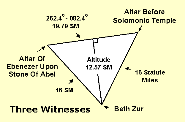
So, again, what is the number 50,070 all about? Could it be a baseline for a unique triangle connecting the Altar of Ebenezer, the altar before the Solomonic Temple, and the apex of Beth Zur (the home of the rock)? Each are described as Beth Shemesh, Ir Shemesh, and En Shemesh.
O.K., 50,070 cubits using 25.025 British inches per cubit attributed to the great pyramid of Giza by Smyth and others produced a baseline of 19.79 statute miles. Then, using the Giza circle and square relationship, the altitude of the triangle is 12.6 statute miles and the sides of the triangle are 16 statute miles.
When matters were being searched out the locations of the Solomonic Temple, the Altar of Ebenezer upon Abel, and even the Great Stone Of Abel ... all were unknown. To complicate matters the location of Beth Zur, the home of the rock, was plotted in different locations on different maps. And to even further complicate matters, the distance from each of the different locations of Beth Zur to the traditional temple mount all exceeded 16 statute miles by about 3/4 mile or more.
The search was obviously futile, nothing fit and a nice triangle without some means of positioning it wasn't worth the paper it was sketched on. But, undaunted, the triangle diagram was expanded. That is, each of the 16 statute mile sides were converted to baselines to form two more triangles in hope that something might fit with known sites. But still it was all futile as nothing fit.
Bert Green's Globe and Map Store on Colonial Avenue (Rt. 50) in Orlando, Florida provided a variety of maps and charts of the area but all were to no avail. Meanwhile, on a hunch, a call was made to Hertz car rental seeking a detailed road-street map of Jerusalem. In response, Hertz's London office sent two copies of a street map that arrived about when nothing at all seemed to fit. But since Scripture says that if it's doubled it's of the LORD (Genesis 41:32) and Hertz sent two copies of the same map so the search continued.
The Hertz map was examined in great detail. It's then that the first clue was noted. That is, the Jewish Synagogue, a Russian Church, an Anglican Church, and a British Cemetery shown thereon were all aligned in a straight line about 38 degrees from North, the same angle formed at the top of Giza.
The Hertz map depicted streets with straight lines and curves were angles. This suddenly provided a second and very important clue. That is, 16 statute mile arcs from each of the Beth Zur locations were transferred to the Hertz map and suddenly the eyes were opened just as described by Ir Shemesh (Strong's #5782). Where the 16 statute mile arcs crossed the 38 degree line it was noted that with a slight adjustment a unique point was established in Independence Garden Park to the West of the Hinnom Valley.
From this point lines could be drawn to the angles formed by the roads traversing around the outer edge of the park. Remember, on this map these roads didn't curve but the bends were shown as angles between straight lines. The unique aspect was that with a slight adjustment the point was positioned to where each line from the point to each individual angle in the perimeter road duplicated the seven lines on our three triangle figure that had been created in a futile attempt to position our baseline triangle.
But, this point in the park was almost a mile west of the Dome of the Rock atop the traditional Temple mount. That's when Jeremiah 19:2 and Joshua 15:8 were found:
Joshua speaks of "... the mountain that lieth before the valley of Hinnom westward...."Joshua 15:8
"And go forth unto the valley of the son of Hinnom, which is by the entry of the east gate...."Jeremiah 19:2 KJV
Thus, if the East Gate of the Levitical City opened out into the Valley of Ben Hinnom then the Solomonic Temple had to be West of the Hinnom. Furthermore, the Medaba Map (dated c. 562 AD) (a tile mosaic of Jerusalem found in a Byzantine Church in Medaba, Jordan) revealed that there was no mound where the current traditional mount is located. Instead, it shows a Roman Gate beneath where the traditional East Gate stands. Later, it was learned that in 1971 James Fleming had physically confirmed the existence of that Roman Gate beneath the traditional East Gate.
Therefore, by utilizing the angles revealed by the point in Independence Garden Park West of the Valley of Ben Hinnom and our baseline ... if we went 19.79 statute miles on a bearing of 262.4 degrees from that point in the park we should come upon an altar atop the Great Stone Of Abel. And that's exactly where the Altar of Ebenezer was found atop Abel when that site was visited on 10 February 1985.
SEARCHING FOR GOD'S HOLY ARK
PART III
BETH ZUR & BEIT SUR


| Prepared By Father - Son Team George & Dana Brown P.O. Box 320932 Cocoa Beach, Florida USA 32932-0932 Email: brianshouse@yahoo.com
|