Site hosted by Angelfire.com: Build your free website today!


A Physical Description of the USGS Liberty Quadrangle
including
Geological, Hydrologic, Climatic and Biogeographic features.
Written by Peter Nichol
Note: ?'s = degree marks


This is a physical description of the Liberty Quadrangle 7.5 minute series (topographic) map located within the central portion of Washington State. This quad is located between latitude 47? 22' 30" N and 47? 15' N and longitude 120? 45' W and 120? 37' 30" W. The UTM locations found within this quad are between 5,249,075mN and 5,235,100mN Northing and 670,100mE and 679,800mE Easting. This is a mountainous region that harbors many qualities similar to other Eastern Cascade terrain within Washington State. Beginning in the southern portion of the quad and moving north you experience a general rise in terrain. As you move north you gain elevation, from a low point of 2,800ft within the town of Liberty at UTM 677,000mN Easting and 5,235,800mN Northing, to a high point on of 5,510ft on Blewett Pass at UTM 672200mN Easting and 5,248,500mN Northing. A few natural features stand out amongst others within this quad. Through the center runs Swauk Creek, this creek is surrounded on either side by rising elevations. To the east is the Swauk Ridge with a high point of 4,205ft; to the west is the Teanaway Ridge with a high point of 5,361ft. Blewett Pass, the high point of this quad, representing the backbone of the Wenatchee Mountains, occupies the norther portion of the quad.

The geology of this quad is described as Eocene volcanic, and is referred to as The Swauk Formation. This formation is common to most other mid level (2,000ft-6,000ft) quads within this region and to the north along the eastern slopes of the Cascades. This type of rock is predominantly characterized as plainly bedded basalt flows and flow breccia made up of sandstone, conglomerate and shale. In color, the sandstone is grey, with light grains of feldspar and quartz, dark flakes of mica can also be noticed. The Swauk formation has been subject to forces which have changed the beds from the horizontal position in which the sands and muds were originally deposited from the last Ice Age, almost 15 thousand years ago. These deposits have now folded, creating slightly inclined beds. The Swauk Formation can be described as a simple formation, consisting of arches and troughs. The axes of these are described as trending northwest-southwest. The Swauk Formation ranges between 300ft and 4,000ft thick, where higher mountainous elevations are generally the thickest.

There are no large bodies of water or rivers within the Liberty Quad; there are however a few perennial creeks. The Swauk Creek is the predominant creek running through almost the entire length of the quad. Most all other creeks drain into the Swauk Creek before leaving the quad in a generally southern direction. This is because of the overall shape of the topography within the quad; as a U-shaped valley, the Swauk occupies the center, and the Teanaway and Swauk ridges rise up from either side. In springtime, the Swauk Creek can swell to a width of 10-15 feet and a depth of 1-1.5 feet as a result of snow-melt due to warming temperatures.

To describe the climate of this quad I will employ the Koppen Climate Classification System, an empirical approach classifying climates by observing differences in temperature and moisture. The climate can be classified as a mix between BSK (cold mid latitude steppe, hot summer) representing the southern lowland portion, and Cfb (marine west coast with little dry season, warm to cool summers) to describe the higher mountainous region to the north. On an average, winter month temperatures stay cold, between 25?-35?, with deep snowfall in the higher elevations compared to lower elevations. Summer month temperatures range on average between 60?-70?. There is little precipitation in the summer months, about .5 inches. Summer months are long, usually hot and dry, and forest fires are a constant danger. Winter months in comparison experience much more precipitation, between 3-5 inches, especially in the upper elevations. Because of the somewhat high precipitation during winter months, the steep slopes found within the northern portion of the Liberty Quad are vulnerable to a fair amount both of chemical and physical weathering.

Tall dense conifer forests dominate the higher elevations, classified as the Canadian Zone; these unbroken stretches extend far beyond the extent of the Liberty Quad and throughout the entire length of the Cascades. These high elevation forests are rich in Douglas Fir, Sub-Alpine Fir, and Larch which share a rich under layer of shrubs and other small but thick plants. Fungi, various orchids and heather species can also be found within the quad at mid to high altitudes. High alpine meadows are scarce and scattered in a few locations within the quad. A rich humis layer in the soil supports large numbers of saprophytic plants. These plants lack chlorophyl, a key ingredient in creating energy from sunlight through photosynthesis; in turn they live on the large amount of decaying organic matter within the soil. This type of soil, classified as alfisols, are commonly found within mid-latitude coniferous forests where all horizons within the soil are well developed. As a whole, the soil found within the Liberty Quad can be described as Alluvium; mostly silt, sand and gravel valley fill, with some clay mixed with peat, as well as artificial fill and glacial deposits.

At lower elevations most underbrush species are replaced by Douglas Fir and Ponderosa Pine. Just above the grass lands, within the southern most portion of the quad, are almost pure stands of Ponderosa. There is a rich under layer of shrubs, located specifically at wetter sites, such as along rivers and streams. Within these areas are also found deciduous trees and herbaceous plants, such as ferns. The lower elevations are much more bare in vegetation than the higher elevations; many more meadows and grass lands are common within this transition zone.

There are many life species that inhabit the Liberty Quad and surrounding region. Mammals include such big game animals as elk, deer, mountain goat, and sometimes black bear. Smaller animals can include but are not limited to shrews, bats, rabbits (snowshoe and cottontail), marmot, squirrel, chipmunk, gopher, mouse, vole, racoon, badger, wolverine, weasel, fox, and the lynx. Bird species can include hawks, grouse (blue and spruce), white tailed ptarmigan, solitary sandpiper, owl (great horned and great grey), woodpecker, swallow, j-birds, chickadees and osprey. Amphibians, located along specific streams can include the northwestern salamander, rough skinned newt, tailed frog, western toad and the cascade frog. The only reptiles common within this region are garter snakes.


grouse
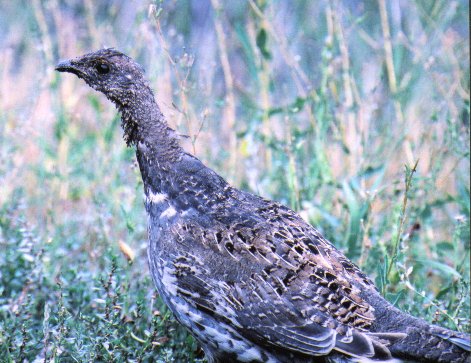
Blue Grouse common within the Swauk Creek Valley.

squirrel
Flying Squirrels are also very common within the Swuak Creek Valley.

larch
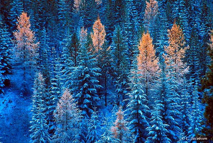
Larch trees in late fall. Different from Douglas Fir, Larch needles change color seasonally.

swauk
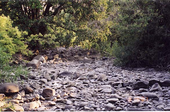
Swuak Creek During the drought of 2001.


Source List:

1) Washington State. Division of Mines and Geology. Geologic Map of Washington. 1961.

2) United States. Department of the Interior. Geologic Atlas of the United States, Mt. Stuart Folio. 1904.

3) Washington State. Department of Natural Resources. Washington Environmental Atlas. 2nd Edition. 1975.

4) Christopherson, Robert W. Geosystems: An Introduction to Physical Geography. 4th Edition. New Jersey: Prentice Hall, 2002.

5) McCurnin, Tom. Ghost Towns of Washington. 13 Feb. 2002. www.ghosttownscom/states/wa/liberty.html.

6) C. Jacobson. Photo Trip USA. 13 Feb. 2002. www.phototripusa.com/.../17406uaBlewettPassLarch.jpg

7) Davis. Carol. Utah Wing. 10 Feb. 2002. www.xmission.com/~cldavis/birds94.html


Home