
| Home | About Me | Alpine Climbs | Scrambles | Ice Climbs | Mountain Links | Guidebooks | |
Note for June 23, 01: - I climbed this mountain with the Alpine Club of Canada. The participants in the trip were Frederic Lebarre(Trip Leader), Jerry McKay, Cyrus K., Kyle Oak (Myself), Dave, Bob, Paul, and Jan Triska. This was the best scramble I have climbed so far. After bushwacking for around 45 minutes, the scramble ascends the ridge described in Alan Kane's book. The ridge has some exposure but is generally pretty solid rock. After ascending the ridge we dipped down to the slope below the summit ridge and kick stepped our way up. After gaining the slope we traversed the summit ridge. 4 hours and 14 minutes from the car, I made it to the top. The weather was generally sunny.
Dates Summited -June 23, 01(Kyle)
Elevation -2970m(9,744Ft.)
Elevation Gain - 1170m
Location - Smith-Dorrien

June 23, 01- Here we are emerging from tree line. We were pretty happy to get out of the trees because the bushwacking was pretty thick. Dave was carrying a GPS system so we were helped out a bit. Don't ask me how to use them though.
|

June 23, 01- After leaving tree line we gained the north-west ridge. It was pretty exposed and sometimes loose. Bob dislodged a very large rock that hit him in the face, broke his glasses and gave him a scar on his nose. After around an hour of traversing the ridge, we needed to traverse around an overhanging slab. Here is a picture of Frederic doing just that.
|
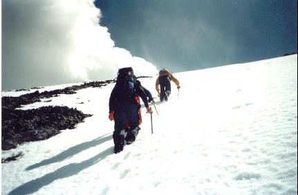
June 23, 01- After traversing the overhanging slab we scrambled up slabs (The degree in the picture 1 photo above) for around twenty minutes to half an hour. I took a small slip on one occasion and luckily stopped myself or else I would have taken quite a tumble. In this picture to the left we are ascending the snow slope that led to the final summit ridge. This allowed the other guys to kick steps up to the summit ridge and let me follow easily in their all-ready built steps.
|

June 23, 01- Here are the last couple steps that led to the summit. The arrow shows where I was standing in the photo below. I made sure that someone went before me to make sure that the cornice was stable enough to support us. I wasn't going to go first! |
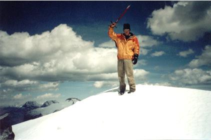
June 23, 01- Here I am standing on top of the cornice. It was a couple feet taller where the summit cairn was so I wanted to stand on the highest part of the summit. A cornice is a drift of snow that builds up through the winter and stays right till mid summer. They are highly dangerous because they form over drop-offs and if you were standing on one when it fell off you would go straight down with it. |
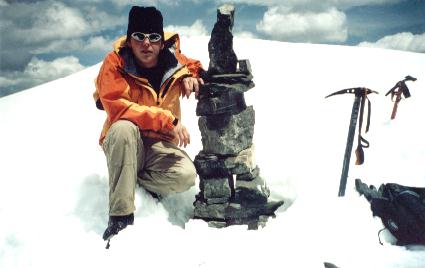
June 23, 01- Here I am sitting by the cairn. We searched around the cairn for the summit register but we could not find it. I think we could have been the first ascent of the season because Alan Kane says that it is a rarely climbed peak. But I am just guessing, we could have been beaten by another party earlier in the season. |
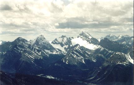
June 23, 01- Here is Mt. Sir Douglas from the summit. The glacier below Sir Douglas is the Robertson glacier (I think). The mountains to the left are named but I don't know the names. That's up for you to decide. |

June 23, 01- Here we have Mt. Assiniboine (Center) and surrounding peaks from the summit. Assiniboine is a mountain I hope to climb in the future, in a couple of years. It is the seventh tallest mountain in the Canadian Rockies and stands at 11,870 Feet. It is known as "The Matterhorn of the Canadian Rockies," because of it's shape, size and beauty. |

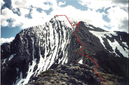
June 23, 01- Here is Mt. Buller from the climb. The ascent route is outlined in red. A guy died on this mountain years ago from rock fall as he was ascending the gully. |

June 23, 01- Here is the route we took for descent. The route is the gully outlined in red. At times there were a few tricky places because of a waterfall that intruded our descent route. However we all made it down alive. We still had to bushwack through the trees 2 km's to get back to the car though. At times we felt a bit "Off track" (Or in other words a climbers way of saying "I'm lost"!) Thanks to Dave's GPS, we made out O.K. |
