
Introduction Cradle Mountain - Lake St Clair The South - West The Southern Forest Mt Field Central Plateau, Western Tiers and the Walls of Jerusalem Frecinet National Park and Environs Tasman Peninsula State Forests and Forest Reserves Rusty Relics of Past Enterprise City Escapes Coast and Islands


Tasmania's bush walking terrain is unique in global terms. The island presents walkers with an incredible 1.38 million hectares of World Heritage Area alone with more than 1000 kilometres of walking tracks and routes. Added to this are more than 150 National Parks, State Forests, Forest Reserves, Nature Reserves and Historic Sites. Together, these expanses provide a stunning variety of land forms, a fascinating botanical diversity and walks suitable for all ages and skills. Top
 No
trip to Tasmania could be considered complete without a visit to the Cradle
Mountain - Lake St Clair National Park. Accessible from both ends, the
park has a network of walks to suit all skill levels, including the classic
north-south traverse - the Overland Track, Tasmania's favourite long distance
walking track. Vegetation includes alpine moorlands, rainforests, sub-alpine
heaths and buttongrass sedgelands. The Visitor Centre at Cradle Valley
has information on all the tracks in this unique glacier-gouged area. Walks
start with gentle nature rambles. More energetic day-long forays from the
comfort of cabins, campground or guest lodges are also very popular. The
trails have their own special attractions; their names alone spell it out.
Visualize the Ballroom Forest Walk, Lake Dove, the Crater Lake traverse,
or the Pencil Pine Track. At the southern end of the park is Lake St Clair,
Australia's deepest lake. Encircled by mountains, its alpine beauty is
complemented by delightful lakeside paths through tranquil rainforest.
The Watersmeet Nature Walk takes only half an hour, but passed through
six different vegetation communities. From Mt Rufus the main peaks of the
park are visible as well as the peaks of the west coast and much of south-west
Tasmania! This walk and climb is a day-long hike of 20km. Lake St Clair
also has boating and trout fishing, picnic grounds and a kiosk. A campground
and cabins are popular for overnight or longer stays. As much as everyone
would love to do it, age, fitness and time preclude many from donning a
17kg pack to hike the Overland Track. For those who can, this is one of
the world's great treks. It can be completed in as little as five days,
but delightful detours - such as to the summit of Mt Ossa, or down steep
gorges to glimpse the dank, dark streams and waterfalls that nurture forests
of myrtle and king Billy pine, or side-trips round glacial tarns, can easily
extend the trip. Experienced commercial operators offer guided walks and
accommodation, and will transport your packs for you! Top
No
trip to Tasmania could be considered complete without a visit to the Cradle
Mountain - Lake St Clair National Park. Accessible from both ends, the
park has a network of walks to suit all skill levels, including the classic
north-south traverse - the Overland Track, Tasmania's favourite long distance
walking track. Vegetation includes alpine moorlands, rainforests, sub-alpine
heaths and buttongrass sedgelands. The Visitor Centre at Cradle Valley
has information on all the tracks in this unique glacier-gouged area. Walks
start with gentle nature rambles. More energetic day-long forays from the
comfort of cabins, campground or guest lodges are also very popular. The
trails have their own special attractions; their names alone spell it out.
Visualize the Ballroom Forest Walk, Lake Dove, the Crater Lake traverse,
or the Pencil Pine Track. At the southern end of the park is Lake St Clair,
Australia's deepest lake. Encircled by mountains, its alpine beauty is
complemented by delightful lakeside paths through tranquil rainforest.
The Watersmeet Nature Walk takes only half an hour, but passed through
six different vegetation communities. From Mt Rufus the main peaks of the
park are visible as well as the peaks of the west coast and much of south-west
Tasmania! This walk and climb is a day-long hike of 20km. Lake St Clair
also has boating and trout fishing, picnic grounds and a kiosk. A campground
and cabins are popular for overnight or longer stays. As much as everyone
would love to do it, age, fitness and time preclude many from donning a
17kg pack to hike the Overland Track. For those who can, this is one of
the world's great treks. It can be completed in as little as five days,
but delightful detours - such as to the summit of Mt Ossa, or down steep
gorges to glimpse the dank, dark streams and waterfalls that nurture forests
of myrtle and king Billy pine, or side-trips round glacial tarns, can easily
extend the trip. Experienced commercial operators offer guided walks and
accommodation, and will transport your packs for you! Top
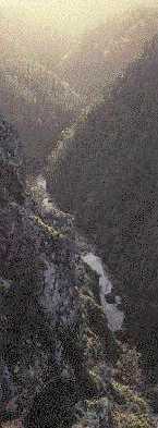 Among
the most popular destinations for the more experienced bushwalkers are
the Franklin-Gordon Wild Rivers National Park and its southern neighbour,
the Southwest National Park. The area they cover is untamed, remote and
noted for its wild weather! The landscapes of the region present dramatic
contrasts. Steep, rugged ranges rise from the flat plains. The coastal
cliffs drop sheer to the sea; sandy beaches are waveswept, white and unspoilt.
A main artery of the south-west is the Franklin River. It snakes some 125km
before merging with the Gordon River and is especially spectacular when
it pours through narrow gorges with 100m high rock overhangs and masses
of battered, water-sculpted boulders. The rivers host an abundance of wildlife
from mountain trout and shy platypus to beautiful azure kingfisher. Scotts
Peak to Melaleuca in Bathurst Harbour, the Mt Anne area, the Southern Range,
Precipitous Bluff, the Western and Eastern Arthur Ranges and Frenchmans
Cap - these are the best known challenging walks. The 85km South Coast
Track from Cockle Creek to Port Davey, is another very special outdoor
experience. Skilled tour operators are available to lead parties through
this wild and extraordinary area. However, you don't have to be a seasoned
bushwalker to access the south-west. The walk from Cockle Creek to the
wild vistas at South Cape Bay is an easy day trip. Along the Lyell Highway
between Lake St Clair and Queenstown there are superb views of the Southwest
National Park plus a few short strolls into the area - and you might even
be lucky enough to see Franklin River rafters about to launch another dramatic
expedition! Surprise Valley and Donaghys Hill Lookouts both provide fine
wilderness panoramas. The highway crosses the Franklin River and a walking
track follows its course a short way. Another view of the famous Franklin
can be seen from the Frenchmans Cap walking track where a fifteen minute
ramble brings you to the aerial cableway constructed for walkers to cross
the river. Franklin River rafters set off from a spot accessed by a ten
minute walk from the Alma River crossing. A walk which is neither physically
demanding nor time-consuming, but which provides a great chance to see
some of the South-West National Park from the inside is the Creepy Crawly
Nature Trail. This 20-minute trail winding along duckboard platforms is
located between Maydena and Strathgordon on the Scotts Peak Road. Top
Among
the most popular destinations for the more experienced bushwalkers are
the Franklin-Gordon Wild Rivers National Park and its southern neighbour,
the Southwest National Park. The area they cover is untamed, remote and
noted for its wild weather! The landscapes of the region present dramatic
contrasts. Steep, rugged ranges rise from the flat plains. The coastal
cliffs drop sheer to the sea; sandy beaches are waveswept, white and unspoilt.
A main artery of the south-west is the Franklin River. It snakes some 125km
before merging with the Gordon River and is especially spectacular when
it pours through narrow gorges with 100m high rock overhangs and masses
of battered, water-sculpted boulders. The rivers host an abundance of wildlife
from mountain trout and shy platypus to beautiful azure kingfisher. Scotts
Peak to Melaleuca in Bathurst Harbour, the Mt Anne area, the Southern Range,
Precipitous Bluff, the Western and Eastern Arthur Ranges and Frenchmans
Cap - these are the best known challenging walks. The 85km South Coast
Track from Cockle Creek to Port Davey, is another very special outdoor
experience. Skilled tour operators are available to lead parties through
this wild and extraordinary area. However, you don't have to be a seasoned
bushwalker to access the south-west. The walk from Cockle Creek to the
wild vistas at South Cape Bay is an easy day trip. Along the Lyell Highway
between Lake St Clair and Queenstown there are superb views of the Southwest
National Park plus a few short strolls into the area - and you might even
be lucky enough to see Franklin River rafters about to launch another dramatic
expedition! Surprise Valley and Donaghys Hill Lookouts both provide fine
wilderness panoramas. The highway crosses the Franklin River and a walking
track follows its course a short way. Another view of the famous Franklin
can be seen from the Frenchmans Cap walking track where a fifteen minute
ramble brings you to the aerial cableway constructed for walkers to cross
the river. Franklin River rafters set off from a spot accessed by a ten
minute walk from the Alma River crossing. A walk which is neither physically
demanding nor time-consuming, but which provides a great chance to see
some of the South-West National Park from the inside is the Creepy Crawly
Nature Trail. This 20-minute trail winding along duckboard platforms is
located between Maydena and Strathgordon on the Scotts Peak Road. Top
 For
those without the energy or time to explore the vastness of the south-west,
perhaps the next best thing is the view from the Waratah Lookout at the
Hartz Mountains National Park, an easy drive in the Huon district. The
Hartz Mountains are located deep within the southern forest, and there
could be no better introduction to the region than the Esperance Forest
and Heritage Complex at Geeveston, which focuses on the 110,000 hectares
of production forests in the area and has a large interpretative and craft
gallery. It also offers forest walks, easily accessible from the nearby
Arve Road. The Esperance Forest Tour is a self-drive trip wending its way
through some of Tasmania's prime timber producing forests and looking at
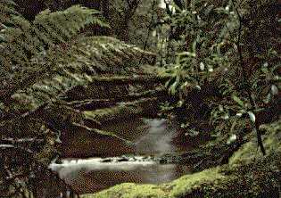
the history and future of wood production. The Keogh's Creek Walk offers
a variety of forest environments and close inspection of rainforest species.
An enclosed bridgeway offers all-weather viewing and photography. Picnic
in Tahune Forest Reserve, and then enjoy a short walk beside the Huon River
and through Huon pine trees growing in their natural habitat. Top
For
those without the energy or time to explore the vastness of the south-west,
perhaps the next best thing is the view from the Waratah Lookout at the
Hartz Mountains National Park, an easy drive in the Huon district. The
Hartz Mountains are located deep within the southern forest, and there
could be no better introduction to the region than the Esperance Forest
and Heritage Complex at Geeveston, which focuses on the 110,000 hectares
of production forests in the area and has a large interpretative and craft
gallery. It also offers forest walks, easily accessible from the nearby
Arve Road. The Esperance Forest Tour is a self-drive trip wending its way
through some of Tasmania's prime timber producing forests and looking at
the history and future of wood production. The Keogh's Creek Walk offers
a variety of forest environments and close inspection of rainforest species.
An enclosed bridgeway offers all-weather viewing and photography. Picnic
in Tahune Forest Reserve, and then enjoy a short walk beside the Huon River
and through Huon pine trees growing in their natural habitat. Top
Mt Field National Park - Tasmania's oldest and most popular national park - offers everything from gentle forest walks to winter ski fields. A favourite campground and picnic spot is near the famous Russell Falls, which cascade amid tall eucalypts and shady fern glades. The falls are easily reached even by the elderly, the very young or the disabled. Learn more about the forest in the Tall Trees interpreted walk, a sedate 1km stroll along a duckboard trail, or take the Lyrebird Nature walk. Drive on up the mountain to the pristine stillness of Lake Dobson and explore the beautiful Pandani Grove. Yet higher, Mt Field offers exquisite carpets of flowers in the summer months and exhilarating ski fields in winter. Pencil pines, lichen and mosses around the small tarns are always a delight, but the splendour of the golden deciduous beech makes this a photographer's delight. Top
The Central Plateau features some notable walking tracks such as Pine Lake and the Devils Gullett State Reserve. The latter is not for the faint-hearted - the 15 minute walk leads to a viewing platform bolted onto the cliff, with 100m of empty space below! The area between Lake St Clair and the Western Tiers is another photographic wonder. The alpine plateau contains 4000 lakes and tarns in an area of about 40km by 15km! The Walls of Jerusalem is a central basin bordering glacially formed lakes, surrounded by five main peaks. It is a popular 14km walk best done as an overnight camp. Top
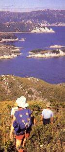
A total contrast to the Central Highlands, Freycinet National Park has long been a favourite with its spectacular pink granite monoliths, expansive sandy beaches, sparkling turquoise waters and warm East Coast climate. Coles Bay is a pleasant resort town and a good base for exploring the park and beaches. Accommodation is available. The famed Wineglass Bay walk is well worth a day trip, even with young children. Take your tine to admire the views in both directions as you climb the saddle and descend to the magnificent beach. You can return by the same route, or via a longer circuit across the isthmus to Hazards Beach and pretty Honeymoon Bay. Mount Graham and Cooks Beach offer overnight hikes in this beautiful area. Further north is the Moulting Lagoon Bird Sanctuary, Bicheno with its nightly penguin parade, and the Douglas Apsley National Park. Top
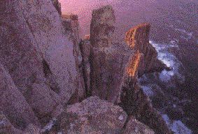 Towering
cliffs, magnificent forests, unique rock formations, convict ruins and
secluded ocean beaches are all found on the Tasman Trail, a first class
walking track. Popular Fortescue Bay, the trail's southern terminus, offers
campsites, fishing and boating. Continuing eastward, the Cape Hauy Track
leads to the fantastic rock spires of the Candlestick and the Needles,
and cliffs of columnar dolorite 300m or more high. On the western side
of the Peninsula waves crash against jagged rocks hundreds of metres below
as you walk along cliff tops to Cape Raoul. Discover Tasmania's brutal
convict history at Port Arthur, marvel at the Blowhole, the Tasman Arch
and the Remarkable Caves. Spend a day or a week on the Tasman Peninsula;
its infinite variety is impressive. Top
Towering
cliffs, magnificent forests, unique rock formations, convict ruins and
secluded ocean beaches are all found on the Tasman Trail, a first class
walking track. Popular Fortescue Bay, the trail's southern terminus, offers
campsites, fishing and boating. Continuing eastward, the Cape Hauy Track
leads to the fantastic rock spires of the Candlestick and the Needles,
and cliffs of columnar dolorite 300m or more high. On the western side
of the Peninsula waves crash against jagged rocks hundreds of metres below
as you walk along cliff tops to Cape Raoul. Discover Tasmania's brutal
convict history at Port Arthur, marvel at the Blowhole, the Tasman Arch
and the Remarkable Caves. Spend a day or a week on the Tasman Peninsula;
its infinite variety is impressive. Top
 Variety
and accessibility are the keynotes in a series of rewarding strolls in
the Forest Reserves that freckle a map of Tasmania. All are easily reached
by car and hove short, developed walks and picnic areas. Forest Reserves
are found within State Forests. There are less constraints than National
Parks - pets are allowed, for example, as are campfires.
Variety
and accessibility are the keynotes in a series of rewarding strolls in
the Forest Reserves that freckle a map of Tasmania. All are easily reached
by car and hove short, developed walks and picnic areas. Forest Reserves
are found within State Forests. There are less constraints than National
Parks - pets are allowed, for example, as are campfires.
They also offer access for four-wheel driving, horseriding, fishing, orienteering, hunting and trail bikes. Sandspit Forest Reserve lies just 15km south of Orford on Tasmania's sunny East Coast. Here the moist shelter offered by the Sandspit River Valley has created a rare patch of rainforest which has survived the dry surrounding conditions for thousands of years. Hollybank Forest Reserve is just 26km north-east of Launceston. There's a large picnic and recreational area with plenty of shade and a number of pleasant walks. Just 20km south-east of Deloraine is the Liffey Forest Reserve. The imposing two-tiered Liffey Falls are set in magnificent forest, with a series of smaller cascades and falls beside the short access track. And in the North-West, Sumac Forest Reserve offers a host of short walks and picnic areas, an ideal day's exploration from Smithton to Stanley. Top
There are some fascinating walks, often in unexpected places. which have their origins in mining and logging activities. They tell of considerable human endeavour and are a fading tribute to the practical engineers of the past. Montezuma Falls on the West Coast is a good example. A walking track follows a tramway which operated between 1898 and 1932 to develop mines between Dundas and Williamsford; several old tramways and haulages branch off. The three tier falls make a fine 110m cascade. Walks to Lake Cumberland in the Heemskirk range, to the Cornwall Mine near Trial Harbour, to Lake Margaret, and along the abandoned ABT Railway between Strahan and Lynchford all reveal the remarkable enterprise of yesteryear. The opposite corner of the State, the north-east, had a tin mining boom from the 1870's. Chinese labour was imported to some of the mines. The St Helens History Room provides an excellent series of guided and instructive walks into the almost forgotten world of the Blue Tier mining area, water races and hydraulic slicing. Top
There's an entertaining diversity of walks within easy reach of Hobart,
our thriving, yet tranquil capital. Just a half-hour drive from the
city centre, the summit of Mt Wellington provides splendid panoramic views
of southern Tasmania. Scores of day walks, of varying degrees of
difficulty, provide the perfect escape only minutes from the bustle of
town. The mountain is noted for its diverse birdlife, and about 55
species are observed on a regular basis. Other urban centres also
offer quick escapes. In Launceston, theres the delightful Cataract
Gorge, less than five minutes from the GPO; Burnie has its tranquil Fern
Glade, and it is the same elsewhere. No town or village is cut off
from interesting walks within cooee of the main street. Many of the
urban walks, and several popular sites further afield have easy access
for the physically handicapped. These include the Cradle Mountain
Visitor Centre, Heritage Landing on the Gordon River as well as the Hastings
and Marakoopa caves. Top
One of the delights of Tasmania is the necklace of beautiful, often-deserted, beaches fringing the island. The north-east is especially blessed, with fine coastal shores from Chain of Lagoons to Georges Bay, Bay of Fires and Mt William National Park. Another prime destination is the Asbestos Range National Park with its boardwalk leading through wetlands and a freshwater lagoon to the ocean. Rocky Cape National Park with its rugged coastline, was once a popular Aboriginal hunting ground and evidence of their habitation may be seen in various shelter caves. In the far north-west at historic Woolnorth a guided beach walk takes in Tasmania's northernmost point - with the worlds cleanest air an extra bonus at Cape Grim. The larger islands off the coast each have an individual identity. Bruny with historical links to Cook and Bligh, has forest and coastal walks. Maria Island also has fine walks, and a fascinating history from the convict period. Flinders Island has wonderful beaches, jagged, mountain peaks, barren wetlands and deep rainforest gullies. King Island is known for its gourmet food products, long beaches, kelp industry and shipwrecks. Short half-day walks to full expeditions are offered by a number of specialized tour operators. Top
