|
Growth Impact Action Committee
|
|
Boundaries: Horry County Council District 4 Click the section you want to view in the table below:
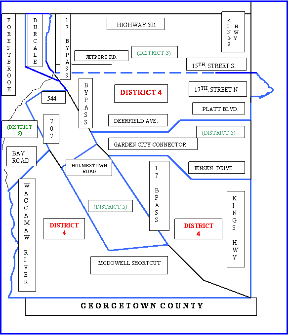
Horry County Council District 4 Boundaries: For precise information on your voting district and precinct, call and give your street address to Voter Registration at 915-5440 or click http://www.horrycounty.org/gateway/main.html then click "my neighborhood," click "Submit," type in your street address, click "Submit." click your street address (that appears at the bottom of the dialog box), click "Elected Officials," and scroll down for the information. If you do not live in District 4 but want to contact District 4 voters, its rough boundaries are given in the following text and idealized map. If you wish to move directly to the idealized map, click here. This page offers distilled information from the county web site as to District 6 boundaries below. For information on how to use the county web site directly, see the information under this heading on the District 9 GIAC page. District 4 runs inland from Kings Highway just north of Georgetown County, westerly along the county line to the river, northerly up the river and the Intracoastal Waterway to Bay Road, east on Bay Road to 707, northeast along 707 to Big Block Road, east on Big Block Road to 544, southeast on 544 to the 17 bypass, northeast on the 17 bypass to around the North Gate of the AFB and northwest across Folly Road and the Intracoastal Waterway to east of Riverside Drive then north across McCormick Road roughly midway between and paralleling Burcale Road and Forestbrook Road to 501, then southeast on 501 to the Intracoastal Waterway, then south on the waterway beyond Harrison Boulevard, then overland to Highway 15 (Broadway), east on 15 to beyond 17th. Street South in Myrtle Beach, then overland to15th. Street South to the ocean, southwest down the ocean to 17th. Avenue North in Surfside beach, inland to the service road just west of Kings Highway, south on that service road to Platt, west on Platt to Deerfield Avenue and then a little south parallel to Deerfield Avenue to the 17 bypass, south on the bypass to Holmestown Road, west on Holmestown to 707, south on 707 to Rosehall Drive extended and then south east to pick up McDowell Shortcut, southeast on McDowell Shortcut to the Inlet Square Mall area, then north on the 17 bypass to the Garden City Connector, turn east on the connector and shortly before the Indian Wells club house, bend south to pick up Jensen Drive, then east to Kings Highway and finally south to the Georgetown County line again. If you want to return to the top of this page click here. Idealized Map: Horry County Council District 4 (foreshortened out of scale, especially north of 544)
If you want to return to the top of this page click here. |
|
If you want to go to another GIAC page, you can use the menu at the top left of the page or click here to go directly to the roadmap page. If you wish to contact us without the world seeing your message, fail to get a timely response or you do not get a confirmation when you submit postings, or want to be put on the GIAC e-mail list, click contact the GIAC web master. Please use GIAC as the first word in your subject line, to help ensure your message is not inadvertently rejected as spam.
|