

Trip Report: Central California USA
In keeping with my goal of traveling more local roads,
here is a report of a ride Conall
O’Brien and I took in early March. The goal was to travel south
down Hwy-1, turn east on the Nacimiento-Ferguson Rd
,
travel across the Fort
Hunter-Liggett military reservation, connect to King
City via the G-14, the 101 North to
Greenfield and then take the G-16/Carmel Valley Road
back to the Monterey Bay area.
See Map
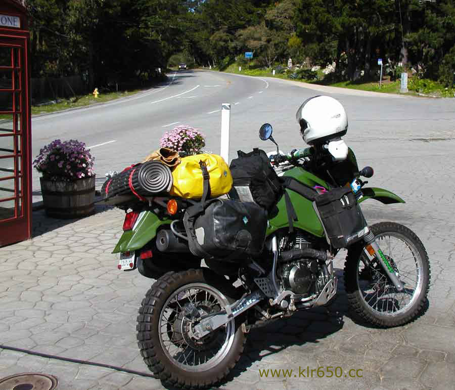
Monday morning I began packing for the trip. First,
choosing which luggage to mount on
my 2000 Kawasaki KLR650. For such a short trip maximum luggage space
won’t be necessary, but it’s nice
to have extra room.
I left my house in Santa Cruz by 12:30pm, perfect
weather and warm enough for only
shorts and t-shirt under riding gear. I arrived at the
Chevron on the Hwy-1/Cabrillo Hwy in
Monterey by 1:30pm and met Conall, who was looking
ready for adventure aboard his '95 KLR650. He led us to the Carmel Highlands gas station
(cheaper than Chevron!) where I
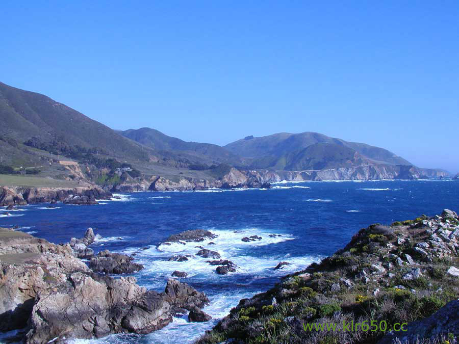
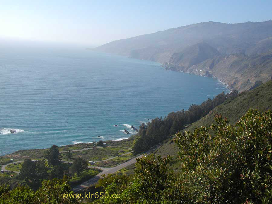
topped-off my tank. We then casually rode down Highway 1
south into the Big Sur area. No
matter how many times I travel this area, it is always
impressive to enter the big
sweepers
and see that ragged, windswept coast in front of you.
Once you pass the Rocky Point Restaurant (the
skid marks are gone now, but I used
to get the creeps passing here and seeing the only
~10-ft. long skid marks left by a
GSXR-1000 that hit a bread truck here at plus 100mph a
few years back) the area really
opens up, no signs of humanity except a few cars
passing. Of course, in the summertime,
that would be lots of cars passing (all following a
slow moving behemoth RV towing an
SUV).
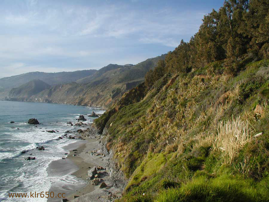
You ride and ride and ride. The road gently curves
back and forth,
emerald
green hills on
your left, sheer cliffs and blue Pacific ocean on your
right. We pulled-over a few times to
soak up the incredible, long-ranging views. As we
approached the Pfeiffer ranger station
pullout, I encountered the only psycho driver of the
trip. I was following Conall, we were
doing the speed limit. Behind me, an older Ford
Fairmount flew-up on me, and after
aggressively tailgating me, attempted to pass me on
the right , with 2-wheels in the dirt.
I blocked this bucket of monkey spunk while monitoring
him to make sure he didn’t ram
into me/us. Given the circumstances, this was less
risky then the possibility of being
forced into oncoming traffic. Plus, if I had let him
by he would of just been on Conall’s
ass. Fortunately, our turnoff arrived and this maddog
driver was left to his own devices
(probably checking out the bottom of a cliff ala
Thelma and Louise-style). We scoped-out
the visitors center, unfortunately they were all out
of maps for the area. The AAA map
shows all the roads we took on this trip, but there
are other roads in the area, including
dirt/Forest Service, etc.
Continuing south, we pulled into The Big Sur Deli and general store
on the right. Conall purchased a
sandwich and I bought a soda (to go with the sandwich
I had brought from home). We
fired down the road to a great lookout spot and had
lunch. Organic necessities out of the
way, we got back on the road and more or less rode
without stopping to Kirk Creek State Campground. This was 51 miles from the
Carmel Highlands gas station
and the campground is almost directly across the road
from the beginning of the
Nacimiento-Ferguson Road east.
We rode into the campground loop, $18.00 per night,
good god! I spoke with the young,
dreadlocked park employee who said that,
unfortunately, no cheaper camping was
available in the immediate area. Obviously, they can
command this price in such a
popular piece of coastline like Big Sur, but many FS
campgrounds are very cheap,
sometimes free such as up in the Modoc Nat’l forest
area. Admittedly though, it did have
flush toilets and running water. The free ones are
usually pit toilets and that’s it.
Relegated to paying the full price, the park employee
suddenly called me back-over.
“You know, there’s almost no occupancy here, why don’t
you just use a bike and hike
spot and park in another empty site.” Cool! Only
$5.00, and wow, what an absolutely
unparalleled camping location.
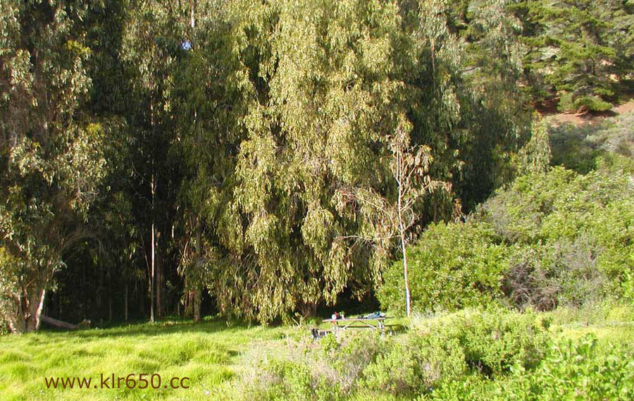
Site E
was at the very
edge of the campground, right on
the bluff with a small forest behind to explore. There
was a trail running down to the
beach. Sitting on the picnic bench, you had a direct
view of the ocean with the sun setting
straight in front of you. Absolutely gorgeous. And
only a 1-minute walk to the bikes. We
went straight into kick-it mode and just enjoyed the
natural beauty surrounding us.
The day was drawing short now. Conall’s camping gear
was unavailable for this trip, so
he headed back home to Monterey (a short ride). I
set-up my tent 20 feet back from the
edge of the cliff. A beautiful sunset was in front of
me as I cracked my first beer (I
experimented with a soft six-pack cooler this time, I
packed-it with a Blue Ice at 11am
and it was still very cold at 6pm, I Love It!).
Actually, I opened the beer and then set
up the tent ; ) And that was my night. Sitting on the
picnic bench, drinking a barley pop
and watching the transition from blood-red sunset to
silvery half moon and brilliant stars.
The only other camper in my area was a Swedish guy who
was pedaling his bike from
South America to Alaska. He told me about traveling
through the Atacama desert.
Later,
when hunger pangs set-in again, I prepared dinner.
Quick, cheap and light was the motto.
I setup my MSR Superfly stove (propane/butane mix,
accepts any brand canister. I have
an MSR International gas stove also, which is
technically more efficient, but I love this
stove for quick trips. No assembly or priming, lights
instantly and it actually simmers. It
has also performed great for me at over 9000ft.).
Back to the Budweiser and looking at the stars. At one
point, while sitting on the picnic
bench I heard a very wild sounding, almost doglike
bark behind me. I whipped-around
and drew my maglite like a gunfighter. The beam nailed
a fox between the eyes, he just
stood there and looked-at me for a while. He appeared
unafraid and eventually trotted-off
into the bushes. I don’t know if he was barking at me
or something else. I made-it to
10pm before crawling into my tent and sleeping bag.
With the proximity of the cliff edge,
high tide and the pounding surf, I could feel the
vibration of bigger waves driving into the
cliff base. That night, absolutely no man made sounds
penetrated my tent walls.
I woke up at around 7am. The entire area was shrouded
in fog and made everything feel
mysterious. I had considered leaving the tent at home
and sleeping under the stars. It’s a
good thing I hadn’t, the fog drizzle was like a light
rain. I staggered out of the tent
towards the picnic table. I rummaged through my food
and cookbags and produced the
Melitta, filters, coffee mug, coffee and powdered
milk. The stove and prefilled pot of
water were already waiting. Within minutes I was
enjoying freshly brewed Santa Cruz
Roasting Company Steve’s Smooth French.
The Swedish
guy was up now and I offered
him a cup. He gladly accepted. He was traveling
ultralight on his bike and didn’t have
such luxuries. He also didn’t have a California road
map, which I found amazing. I gave
him my extra AAA copy. Apparently he hadn’t done much
research for his trip, which I
suppose could add a sense of adventure to a journey. I
gave him a few tips, like
bear-bagging your food in the Northern areas.
Breakfast consisted of a packet of instant
oatmeal, some jerky and a handful of Fig Newtons. Not
exactly eggs Benedict at the Ritz,
but it worked. Actually, I am not a breakfast person
at all, but I force myself when I know
a big day is ahead. Thus fortified, I began breaking
camp. This is the moment when I
truly appreciate less being better. The only slow part
was draping the rain fly and tarp
over brush to dry in the sun (which was now shining
intensely, having quickly burned-off
the fog). Time to dig out the sunglasses, hat and
sunscreen.
Right on time, Conall rolled-up at 10:30am. I
pulled-on my riding gear and did my final
cinching and inspection of the bike. The Kirk Creek
campground entrance is almost
directly across from the beginning of the Nacimiento-Ferguson Rd. You turn south on Hwy-1 out
of the campground, and maybe 100ft. down the road is
the road on the left. It
immediately becomes steep and stays that way. It is
paved, twisty, narrow and there are
no guardrails between you and the precipitous drop.
Extreme caution is needed to be
prepared for oncoming traffic which may also swing
wide on blind corners. That being
said, any bike can be taken on this road. Of course,
it’s better on a KLR ; ) And I mean
that, the easy torque of the 650 rapidly pulls you out
of the slow corner approach speeds
and up the steep hills. A lot of time was spent in
second gear with occasional forays into
third. A few miles into it, we pulled over and
compared deployment of our Dualstar and
Five stars centerstands. Then we lubed our
now-warm chains. The views were
incredible, you are climbing rapidly, and below you
lays a field of green leading to the
blue Pacific ocean, your serpentine path laying in
broken-up sections beneath you, like
some crazy, drunken bulldozer operator had carved the
road (perhaps the IQ-challenged
cager who tried to pass me on the right).
After 18 miles of great coastal range riding, we
arrived at the guardshack for the military reservation. As you approach, Jersey barriers are set
up in a staggered fashion so that a
vehicle cannot run the gate. We wove our way through
them. A sign said “Threat Level
Bravo.” The guard who came out of the shack had the
definite appearance of
military/ex-military, but his uniform appeared to be
that of a private security company.
He was very friendly and very thorough. He checked
both of our registrations, insurance
papers and driver’s licenses. He was very interested
in the KLR’s and recognized them as
the Marines motorcycle
. He gave the thumbs down on the
diesel conversion. He asked a
lot of questions about the motorcycles and gave us
some route advice and heads-up on
the radar traps ahead. The speed limit was pretty
slow, lot’s of 20mph, some 30mph and
occasional 45mph. The road was very good with gentle
curves that you could see
through. It would be fun to be able to lean into them
hard. The only military vehicles we
saw were a large transport truck and a tractor.
Looking around, it was very apparent that
heavy, tracked vehicles are running around in these
hills. Hillclimbs, sand and water
crossings are setup. You could see a few dug-in emplacements. I got the feeling that if
you left the main road it wouldn’t be long before you
were speaking with the MP’s. It
was a very casual ride through the reservation, and
even with the low speeds it didn’t
take long to cross. Near the end, the road temporarily
forks and you have the choice of
either a wide, shallow water crossing or a one-lane
bridge. Naturally we did the water
crossing. Not hard, but fun. About 75ft. of 1-2 inch
water, tires are clean now! On the
west side you pass through another guard-gate with the
barricades on the entrance side.
You didn’t have to stop there. There is a (I think)
Vietnam-era tank on display here
(Pershing?). Here we took a short break and posed for
the obligatory KLRs and tank
pictures.
From there, it is a short trip to Jolon, which is
really just an intersection. We continued
northeast on the G14 to King City
(where I realized
how far south I was from Santa
Cruz, for what was, essentially, a day ride). Then, a
very short (10mile) high-speed blast
up the 101 north to Greenfield. Here you take the main
exit and connect to the northwest
bound G-16/ Carmel Valley Road
. The road is a mixture
of straights and mild curves,
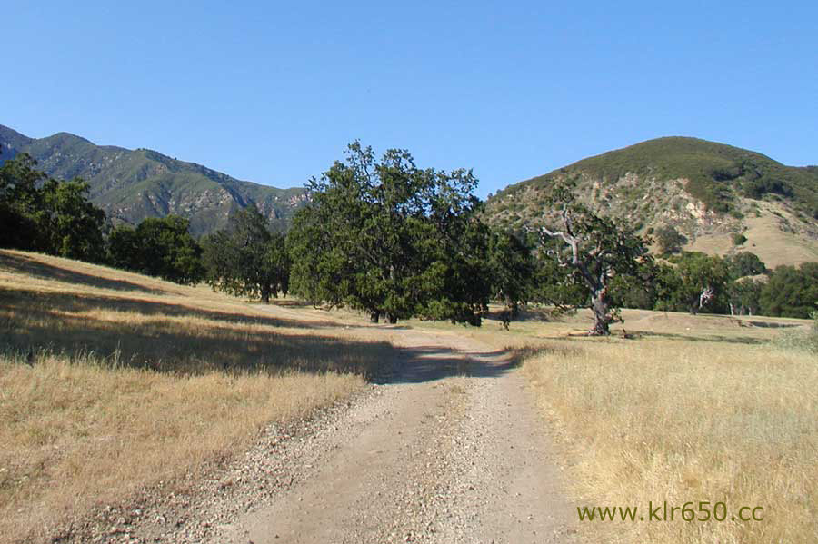
traffic was light. This is a pristine valley, full of
green pastures with livestock wandering
about, including goats (I think there is a goat cheese
farm out there). Another perfect
central California day, the sun shining, blue sky, the
gently rolling green hills and black
oaks straight-out of a Steinback novel. The road
eventually begins to narrow as it twists
it’s way out of the valley. We made a final rest stop
at a point before things begin to
become more “civilized.” We finished our sandwiches
and commented on how the
temperatures were finally dropping. Approximately 60
miles out of Greenfield, we took
the G-20 north to the 68 west which dumps you back
onto Pacific Coast Hwy 1.
We pulled into a gas station where I topped-off for
the ride home. This wasn’t actually
necessary, I had 162 miles on the odometer from the
Carmel Highland’s gas station and
was able to put 3.1 gallons in (52.25mpg). This is the
first real ride after turning my pilot
screw out from factory 1 and an eighth to 1 and
five-eighths. That is almost as high of
mileage as I have ever experienced. The funny thing
is, my pre-adjustment experience
with this bike says that a day of mixed riding like
that, including lots of hill-climbing in
2nd and some crosswinds, should yield in the high 40’s
(less mpg). Perhaps I am
misinterpreting the trips gas needs. Maybe I am
getting the same as always, but I thought
I was supposed to get less mileage (it’s not possible
to get more, right?). Either way, I
can definitely live with this mileage.
We split-off here. Conall went home to Monterey and I
got ready to get back on the 68
for a few minutes to connect to the PC-1 to Santa
Cruz. It was 6:10pm when I left. Close
to dark and colder now. I cleaned the bugs off my
headlight. I exposed the reflector on
the back of my jacket and put on my fleece jacket
liner and midweight Olympia gloves.
Time for the heated hand grips.
(In regards to ideas about mounting switches for
heated grips: My 3-way toggle switch
came with a small metal plate to mount it with. The
grip heater switch and my other
2-way toggle for the lighting system are mounted on
this plate. This plate has a mounting
hole. If you look straight past the left side of your
tachometer, you will see a 10mm nut
that holds the fairing bracket together. This is where
I mounted the switch. The small
plate hangs vertically, with the end of the left
turnsignal stalk right behind it. It is out of
sight and out of the elements. They are both switched
(relay for grip heaters).
I rode the 46 miles in 45 minutes. The last of the
light had left the sky as I approached
Santa Cruz. Traffic was light with the leftover
commute. I made it home by 6:55pm and
pulled into my driveway just as my girlfriend arrived
home from work. I rolled the bike
into the garage and only unpacked the tent to dry-it
and the sleeping bag to
decompress-it. I let everything else wait, I was beat!
It was a great trip, it all happened in the space of
about 30 hours. Total mileage (for me)
was 262 miles. Total cost: slightly under $20.00
including gas. There is
a lot of exploring to do in the Big
Sur area, we discussed the possibility of encouraging
others to join us sometime for a
meet/ride with maybe one night of camping. More on
that later. Thank you to all those
who provided info about the area, and if you haven’t
done this ride, it comes highly
recommended. Happy Trails.
Charles Earl
This page last updated 22-Aug 2007.
Hwy 1/ Big Sur CA/Nacimiento-Ferguson Rd
by Charles Earl
I mounted my Ortlieb saddlebags
(food/cooking gear/tennis
shoes/fleece jacket liner/six-pack of Budweiser/other
misc. camping equipment),
Aerostich front panniers (spare tubes/flat repair
tools/other tools/spare clutch cable, other
extra parts/2 1-liter Nalgene bottles/Leatherman/plate
for kickstand/rock shield for
headlight), Chase-Harper 750 tankbag (thick
gloves/balaclava/helmet
accessories/binoculars/maps/AA maglite/earplugs/other
assorted small bits) and Ortlieb
duffel bag containing my lightweight 2-person
backpacking tent, tarp, sleeping pad,
sleeping bag and clothes. I left the Givi 45L behind.
I could have got away with leaving
either the panniers or saddlebags behind, but then
space would be at a premium and I get
tired of the dance of packing so tightly. I wore my
current outfit of Nolan helmet, 1st gear
jacket and pants and CT boots.
Top
Ramen (.25 cents), tuna ($1.25/3oz
foil pack Starkist tuna, these are great, they’re
light and no water or oil to deal with) and
one carrot (~.05 cents) scraped clean and cut-up with
the Leatherman and simmered for a
few minutes before the noodles and tuna (thank you
Russell Stephen for this idea, I got it
from your last trip report; Carrots! The Incredible,
Edible, Camping Vegetable). A good
meal, hot and fast, eaten out of the pot. (Note to
self: bring a fork next time, noodles and
spoons don’t work well together. In my desire to go
light I just brought a pot and spoon,
but geez, how much could that Lexan fork weigh? I use
my backpacking experience to
pack my motorcycle, but sometimes I ignore the fact
that I can get away with a few more
ounces on the bike.
Continuing
on, you gradually lose sight of the
ocean and are riding through lightly forested areas.
Occasionally, the pavement is slightly
broken-up and in a few curves there were some minor
patches where light gravel had
migrated from the roads edge. It is ~18 miles from the
coast to the west side of the Fort Hunter Liggett
military reservation. About halfway,
there is a Forest Service campground
by a river ($10.00) A very nice spot. Picnic tables,
firepits and pit toilets. We saw our
only other motorcycle sighting here (on this road), it
looked like a FJ1300 (lucky so and
so!). We checked-out each other’s bikes and admired our
various modifications/add-on’s.
I gazed with wonder and awe at Conall’s MAP rotor
setup and then looked dejectedly at
my stock setup. I was also impressed with his
auxiliary cooling fan switch. This is a
must-have item for me. Conall, in a moment of heroic
foresight, had packed along an
enormous, 2-ft. ham and turkey submarine sandwich. We
whacked-it in half with the
Leatherman and conversation temporarily died to a
minimal as we feebly attempted to
make a dent in these sandwiches. We had to move to
another table, for some reason bees
were in a frenzy at the other. Full, after only half
of our portions, we wrapped-them up
and hit the road again.
Santa Cruz, CA
KLR650 A-14
![]() Copyright © 2003-2006 Charles Earl All Rights Reserved
Copyright © 2003-2006 Charles Earl All Rights Reserved
Links to Travel destinations , adventure touring and ride reports
Tom Myers's Oregon BackCountry Discovery Route
M/C Tour,Shipping & Rental Info
Dakar. Jan 1, 2003
Article-M/C touring for beginners.
Northeastern Motorcycle Tours
Wandering Around in South America by Robert Runyard
Alcan 5000 rally
Tom Grenon's Webpage
1998 Tecate-Score Baja 1000
Moab UT USA Tourist Info & Desert safety
Horsethief 500 Travel Expedition
The China Road Dispatches- Carla King
Charles Earl-DUALSPORTMOTORCYLING.COM
M/C Travel- miscellaneous
GPS Guidebook to Baja
Links to World Travelers' Websites-Cycoactive
Horizons Unlimited
Bill Johns' Excellent M/C Camping Guide
California ATV + Dirtbike Riding Area
BMW/HONDA/SUZUKI/YAMAHA Travelers Pages
Transalp/Africa Twin Jumpstation
Tokyo to London Project
Transalp-Photo site:Greece
Big Greg's TA & AT page- Australia
Deti's TA Page
KLR650.cc home
