 South Africa
South Africa
South AfricaOctober 2009
South African Background: “Dutch traders landed at the southern tip of modern day South Africa in 1652 and established a stopover point on the spice route between the Netherlands and the East, founding the city of Cape Town. After the British seized the Cape of Good Hope area in 1806, many of the Dutch settlers (the Boers) trekked north to found their own republics. The discovery of diamonds (1867) and gold (1886) spurred wealth and immigration and intensified the subjugation of the native inhabitants. The Boers resisted British encroachments but were defeated in the Boer War (1899-1902); however, the British and the Afrikaners, as the Boers became known, ruled together under the Union of South Africa. In 1948, the National Party was voted into power and instituted a policy of apartheid - the separate development of the races. The first multi-racial elections in 1994 brought an end to apartheid and ushered in black majority rule under the African National Congress (ANC)” (CIA Website)
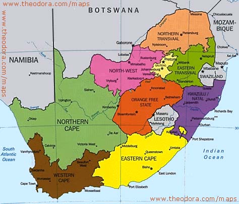
It is the 25th largest country in the world, the size of France and Spain combined. It has a vast interior plateau rimmed by rugged hills and narrow coastal plain. It’s natural resources include: gold, chromium, antimony, coal, iron ore, manganese, nickel, phosphates, tin, uranium, gem diamonds, platinum, copper, vanadium, salt, natural gas. The main agricultural products are corn, wheat, sugarcane, fruits, vegetables; beef, poultry, mutton, wool, dairy products (and ostriches). It has a population of 49 million of which 5.7m live with HIV/AIDS (2nd highest in the world). Black Africans 79%, white 9.6%, coloured 8.9%, Indian/Asian 2.5% . Of the population, 23% are unemployed and 50% below poverty line. 14 languages are spoken: Languages: English, Afrikaans, Ndebele, Sepedi, Setswana, Sotho, Swati, Tsonga, Tswana, Tshivenda, Venda, Xhosa, Xitsonga, Zulu.
The CIA says of the Economy: “South Africa is an emerging market with an abundant supply of natural resources; well-developed financial, legal, communications, energy, and transport sectors; a stock exchange that is 17th largest in the world; and modern infrastructure supporting an efficient distribution of goods to major urban centres throughout the region. Growth was robust from 2004 to 2008 as South Africa reaped the benefits of macroeconomic stability and a global commodities boom, but began to slow in the second half of 2008 due to the global financial crisis' impact on commodity prices and demand. However, unemployment remains high and outdated infrastructure has constrained growth. At the end of 2007, South Africa began to experience an electricity crisis because state power supplier Eskom suffered supply problems with aged plants, necessitating "load-shedding" cuts to residents and businesses in the major cities. Daunting economic problems remain from the apartheid era - especially poverty, lack of economic empowerment among the disadvantaged groups, and a shortage of public transportation.”
Sunday October 12th
(Continued from the Kalahari event). Up at 5am to pack and have the luggage ready for my ride. Anne was conveniently staying next door. Jim carried my suitcase because my feet were so raw. Rhodri appeared rather hung over from the farewell night. Our driver would be Arthur, Anne’s husband. He was 75 and she was 10 years younger. They had run an IT training company in Cape Town, then retired and were now back ‘care taking’ the company.
We set off at 6am and headed west on the N14 to Springbok, via Kakamas and Pofadder. Within half an hour Arthur was dying for a smoke. “I know this is supposed to be a non-smoking car, but I need a cigarette”. Arthur would smoke nearly a pack by the time we were in Cape Town.
Following the Orange River from the park to Kakamas was a rich fringe of vineyards, orchards and alfalfa fields. We passed a system of irrigation canals and tunnels where water was diverted from the river and funnelled around hills and into fields. Any surplus eventually ran back into the river. The narrow canals ran for miles.
We entered the region known as Namaqualand. This North-west Cape is semi-desert, harsh and dry of most of the year and is where the area known as the Karoo merges into the Kalahari. With an economy based almost entirely on a few scattered copper and diamond mines, it is sparsely populated. Springbok is the region’s capital and lays 400km Southwest of Uppington.
In the centre of Springbok was a mound of granite boulders called ‘Klipkoppie’ (rocky hill), the site of a British fort blown up by the Boers in the Boer War. Nearby was the remains of the ‘Blue Mine’, the first commercial Copper mine in South Africa (1852).
We stopped for coffee at the large Springbok Lodge. This had a weird and wonderful collection of photos about the town’s history, and bits and pieces. The proprietor showed us photos of the famous carpets of wild flowers that spring up in the area every August. It must be awesome sight to see.
Travelling south along the N7 from Springbok is a stimulating experience, with the spectacular pink flat-topped mass of the Matzikama Range and the Kamiesburg Mountains that dominate the southern skyline. After passing through Kamieskroon, the mountains gradually gave way to the bleaker landscape of the pebble-strewn Knersvlakte (‘Plains of the gnashing teeth’) referring to the sound made by wagons on the harsh terrain. We filled up again at the small agricultural town of Vanrhynsdorp that was the gateway to the Western Cape region.
I noticed that slower drivers would pull over to the hard lane on the left and let a faster car pass without having to overtake on the opposite lane. The car that overtook would then flash its hazard lights twice to thank them. I would see this road behaviour
throughout South Africa until you got within 500km of Johannesburg. Then it was everyone for themselves.
Sometime in the afternoon, a car in front hit a guinea fowl. These are large birds like peacocks without the huge plumage. Arthur stopped the car and spent ten minutes trying to find it in the undergrowth, while cars tore past. Eventually successful, he carried it back, promising a guinea fowl stew. Arthur was good company with lots of stories. He also translated Africaan signs for the (dry) rivers and towns. En route to Cape Town there was a sign that said, “Please no Hooting. Ostriches getting laid”.
As we approached Cape Town, a dramatic thunder and lightening storm descended and flooded the road in minutes. Cars were pulling over because of the water on the road. It was a hell of an electrical storm and looked quite spectacular with the silhouette of Table Mountain in the background.
Anne and Arthur rented an apartment in the Kenilworth District of Cape Town. They had a house on the Garden Route and had only intended to stay for 6 months sorting out their company. Three years later, they were still there. Rhodri and I were given a room. Arthur poured some drinks and Anne popped out for some takeaways. We were made to feel very welcome. We could also check our emails for the first time since arriving in South Africa. Rhodri was subjected to my loud snoring for the first time.
Monday October 13th
I had previously reserved a car to be picked up in the centre of Cape Town at 9am this morning. I had assumed I would be coming down overnight on a bus but we had sacrificed these for the daytime ride. No problem. There was an overland train that went from Kenilworth to Central Station. Rhodri and I sneaked out around 7.30am, and walked (I hobbled) to the local station. It was packed with commuters and we squeezed on.
When planning my week in South Africa, I thought I would be on my own and intended to do a comprehensive road trip that took in Lesotho and Swaziland on the way. But when I made contact with Rhodri, he said he had a week before flying out of Cape Town. Since many of the sights were in the Cape Town region, it would be a lot more fun to do it with someone else.
Rhodri was 31. An ex-soldier, he was now working for an on-line gambling company, trying to work out international currencies and rates to maximise profits for the company. There was software, but he and his team still had to number crunch. Rhodri was laid back and good fun and we got on well. He was also very fit, having come 3rd in the Kalahari event, but he admitted that he tended to push his body too much and often suffered the consequences.
We found the car rental office a few blocks from the central train station at 9am. My feet felt agony to walk on. The car was ready, a 1400cc Volkswagen Golf – a real mean machine and probably one of the most popular cheap cars in South Africa so it would fit in. After a check of the exterior, we were off. I had read that South African driving and in particular, Cape Town driving was awful, but I found it very civilised and easy. Maybe I have driven through enough countries by now to cope with anything.
With Rhodri navigating, we successfully returned to the apartment in Kenilworth. However, we had forgotten about the security gates. Rhodri had to use one of his old army techniques of waiting for someone to enter and then sneak in behind. Then he let me in. We packed, had breakfast and left a thank you note. Anne and Arthur had offered us a room for the week, but we wanted some freedom and Anne was flying to London the next day to see her first grandchild, so we thought it would be better to leave her completely free. The guinea fowl had been plucked and beheaded and was now hanging up, dripping blood over the draining board. I hoped we might be back to try some guinea fowl stew.
Rhodri was very flexible as to our destination. I had a few places I wanted to see over the next few days and we agreed to start with the wine country. The Boland (‘Upland’), stretching inland and upwards from Cape Town is South Africa’s most famous wine growing area surrounded by dramatic mountain ranges that shoot up to over 1500m.
The sky was still overcast and Table Mountain still shrouded in mist, as we made our way out of Cape Town on the N1 towards Paarl. We passed the large black communities on the ‘Cape Flatlands’. Arthur had told us how, years ago, the ANC had bussed thousands of blacks into the area to sway the electoral system and trying to get their votes by promising to settle them there with decent housing, electricity, schools, hospitals etc. The temporary shantytowns were still there despite the promises. Arthur said he could remember when black people were not allowed to enter Cape Town. I would see many black ‘shanty towns’ outside ‘white towns’ where the locals would catch minibuses or hitch to work in the white areas and then return home. The ‘shanty towns’ were always away from the white areas, so in a sense, an economic apartheid still existed. I picked up a few black hitchhikers during my later days, but few could speak English and were just glad for a ride up the road.
The ‘Cape Flatlands’ had a bad reputation amongst the white Cape Town inhabitants, but on the main Cape Town to Johannesburg highway, they were just a blur as we passed through – except for all the washing hanging on lines outside wooden shacks.
We had three towns to visit today. Paarl (165,000 pop) was the first, of which the ‘Rough Guide’ said is “a prosperous farming centre that earns its keep from the agricultural light industries- grain silos, canneries and flour mills…and the cornucopia of grapes, guavas, olives, oranges and maize.” We were visiting the winelands out of season, so the vineyards were just green leaves.
Paarl Mountain overlooked the town and the Berg River and we drove up to the Taal Monument (1975), an apartheid-era memorial to the Afrikaans language. It was a strange, stark concrete obelisk. From here we had a good view over the valley whose mountains were shrouded by mist. In town, we took in some of the colonial architecture but there was little else to keep us since we weren’t touring wineries.
Rhodri suggested that we check out ‘Du Toit’s Kloof Pass’. Du Toit was a famous road engineer in South Africa that breached mountain ranges in the 19th century with roads. The pass followed a river valley. I tested out the Beast’s acceleration and gear changes as we roared up around the narrow twisty road. Rhodri clung onto the dash board and commented “I think the accelerator pedal works. I just left my guts at that last turn”. With the surrounding mountains covered by mist and a deep river gorge to our right, it was very atmospheric.
At the other end, with the Hex River Mountains before us, we crossed back over the N1 highway and headed through endless low level green vineyards to Franschhoek (13,000 pop). This town had a magnificent setting at the head of a narrow valley, hemmed in from three sides and surrounded by vineyards. The town was established by French Huguenots in 1688. Franschhoek means ‘French Corner’.
Apparently, this small town has established itself as the culinary capital of the country (how do you measure this?). Rhodri, with his bottomless stomach declared we should have lunch. It was around 3pm. We then came across a strange South African phenomenon. To earn some money, black men would don ‘parking jackets’ and then claim ‘free parking spaces’. They would stand at free spaces, direct you in (because after 25 years of driving in countless countries, I obviously can’t park), watch your car and then demand a tip. I know they were just looking for a small income, but I was not impressed and tended to drive off wherever possible.
After we had inspected the restaurant menus and decided that the Rand was stronger than we would have liked, we settled for pizza and a glass of local wine. Both were excellent. I hobbled along the main street taking pictures of the old whitewashed church and colonial architecture. There was something slightly disappointing about the wine region of South Africa. Having lived in Adelaide, Australia and visited the Barossa Valley, which was settled by Germans, I seemed to remember that they had retained the ‘ye olde’ character of the place. I felt with Paarl and Franschhoek that there was no real character to them – just an endless modern commercial build up of
run of the mill, non-descript, endless commercialisation. Maybe that is what tourists want. But, to me, there was no character to the places – just somewhere where tour buses pull up for a stop.
Our final destination was Stellenbosch (220,000 pop), the most popular town in the wine region. “Dappled avenues of three-century-old oaks are the defining feature…Street frontages of the same vintage, street cafes and a European town layout centred on the Braak, a large village green…the undisputed heart of the Winelands” (Rough Guide). It is South Africa’s second-oldest European settlement established on the banks of the Eerste River in 1679.
We found the ‘Stumble Inn’ hostel in the centre, grabbed a couple of beds in a dorm room in a separate building next door and had a drive around before dusk. The Braak had a lovely setting with Mary’s on the Braak church (1852) at one end, and the Powder House (1777) at the other. These, along with endless colonial buildings were all whitewashed. Elegant Georgian and Victorian town houses were also numerous. Our original intention was to do a walk around the centre, but my feet were mashed.
In the evening, we found a posh restaurant and feasted on steak and chips and a splendid bottle of white ‘Roaming Goat’ wine from the local Fairview winery. Rhodri claimed that the £:30 bill would have cost double in London and the steaks were far larger.
We had retired to our dorm by 10.30pm. Rhodri was sleeping above me. There were only two others in our room and we had not seen them. I woke in the middle of the night to see someone thrashing around in a bed next to me in the darkness. He must have checked in late and couldn’t get to sleep because of my snoring. He would get up and disappear out of the room and come back and thrash around some more. When I had a drink of lemonade, he asked for some. I went back to sleep and thought nothing about it.
Tuesday October 14th
When I awoke early the next day, I discovered, now it was light, that the thrashing man was in fact, Rhodri. He had been up all night with constant sweating and bad diarrhoea. “I’ve been waiting for you to wake up for hours” he said, “I’m in bad way.
We need to find a doctor”. So we packed quickly and left the hostel. Rhodri said, “I pity the next poor sod in that bed. I was sweating like a paedophile in a playground. The bed is soaked”.
What do you do when your travelling companion is obviously very sick and it is 7.30am and you are in a strange town? We had both eaten the same meals, so it wasn’t food poisoning. We drove around looking for a sign to a hospital and stumbled across a ‘Medical Centre’ that opened at 8am. Stellenbosch was a hectic place full of school mums and commuters. Traffic lined the roads everywhere. So much for the ‘idyllic colonial town’. Rhodri went in and was welcomed by a nurse who said ‘You look terrible’. 30 minutes later after a full examination by a doctor he reappeared. “It cost me £48 in drugs, but the Doctor said I would get sorted”. Apparently, Rhodri had picked up gastric flu. The doctor’s best guess was he had caught it off someone when we got on the crowded metro train to Cape Town yesterday.
Rhodri had medicine to ‘block’ him up for 6 hours stretches. I dropped him at a coffee shop for his daily caffeine injection while I drove around and took photos of the area around the Braak. Every time I stopped to pop out and snap a photo, a parking warden would indicate that I had to put coins in a parking meter. The parking meters and parking wardens were everywhere. I didn’t like this aspect of Stellenbosch or the morning rush hour. Tourists were arriving at the Tourist Office for their wine tours. It would have been nice to stroll around the town, but like all tourist ‘gems’, the guidebooks never tell you about the traffic rushing past. My feet were happy to avoid it as well.
Although Rhodri was very ill, there seemed little point in hanging around Stellenbosch. We needed better accommodation and hotels were out of our league in this town. I decided to push on with my planned itinerary and let him sleep in the passenger seat.
I headed south to Somerset West and the coastal town of the Strand. Here we picked up essential snacks/drinks in a supermarket and also the attractive coastal road around Gordon’s Bay and down to Hermanus. The blue sea was calm next to a towering range of mountains and the views were breathtaking.
We saw a sign saying ‘Penguins’ and popped into Betty’s Bay to visit the Penguin colony. Or rather we stood outside the fence and used our camera lenses to zoom in on the hundreds of penguins nestled on the craggy rocks by the sea. It wasn’t as if we hadn’t seen them before. Rhodri was awake but still feeling very rough. He was good enough to tough it out, while I continued on.
Hermanus was originally a quiet cliff edge fishing village on Walker’s Bay, but is now a fully blown tourist town with shopping malls, supermarkets and craft shops, based on its reputation as the ‘whale capital’ of South Africa. All guidebooks tell you that this is the place to come and spot whales and we were there at the right time of the year. I parked up, left Rhodri sleeping and walked to the nearby cliffs in front of the endless hotels. Asking a local security guard about whales, he said that none had been spotted in a couple of days. So there wasn’t much point in hanging around. Its funny how you read about such places and imagine a quiet backwater and whales off shore and when you get there, it is nothing like it.
So we headed for Gansbaai, the “shark cage diving” capital. Originally, Rhodri had fancied some of this. My father and brother had done it a few years ago. Although they had been in the cage and seen the sharks, it was a long day of mostly watching everyone else have a spell in the cage (everyone got 30 minutes) and to be honest, you saw more of the sharks from the boat than in the cage. Not that Rhodri was up to it. So we drove straight through the non-descript town. I had also thought I may get a couple of scuba dives in, but was more in the mood for a road trip.
Somewhere outside Gansbaai, I fell asleep at the wheel! Don’t ask me why – maybe the Kalahari event and the endless driving since finishing had finally caught up with me. It was only for a few seconds and when I awoke, we were nearly on top of a road sign on the side of the road. Rhodri woke up at the same time, as I braked and swerved avoiding the sign, but also narrowly missed a car coming the other way. A few expletives were exhaled and I wound down the window for some air.
During this entire day, Rhodri’s guts would need evacuating on a regular basis and I’d be forced to pull up by whatever vegetation I could find and let him out to squat behind the bushes. It was a miserable day for him.
On the road, I noticed a small object. It was a tortoise, but was upside down and completely closed up with some blood on a chipped shell. It had obviously been hit by a car and was ‘shellshocked’ (sorry). I lifted it up and placed it in the undergrowth. As an owner of a tortoise for the last 35 years, I found it amazing to see a wild tortoise.
Our destination today was Cape Agulhas. The coastal road had been closed for repair and I was forced to head inland to Elim and then Bredasdorp before heading south. Many of the roads were just sand tracks but relatively flat. We filled up the car at Bredasdrop and were treated to South African garages, whereby a black youth would fill up your tank, wash your windows and offer to check oil, tyres etc. I always appreciated the good service and politeness and would tip them well.
“Along the east flank of the Danger Point promontory, the rocky and shallow coastline with heavy swells and strong currents makes this one of South Africa’s most treacherous stretches of coast. One that has claimed over 250 wrecks and 2500 lives” (Rough Guide). But Cape Agulhas is more famous as the southernmost tip of Africa.
Nearby was the 1849 lighthouse standing guard. Rhodri and I took the obligatory photos while a small tour group visiting various African countries drank celebration wine out of plastic cups in the wind and tried not to admit ‘Is this it?’ It was worth the drive. A rocky outcrop at the end of a massive continent with the Indian Ocean to our left and the Atlantic Ocean to our right – not that you would notice and not something you do everyday. We had expected a desolate place but Cape Agulhas now has a decent sized town and a garage!
Today’s objectives achieved, we needed somewhere to hole up. Rhodhi suggested Swellendam. His parents had stayed there. So we drove north to the foot of the Langeberg mountains and found an attractive market town with a wide main street. This was South Africa’s third oldest white settlement established in 1745 and it became prosperous as a frontier town, able to equip settlers heading for the interior (even if the place had burnt down in 1865).
Cruising the main strip, we saw accommodation prices on a few places and chose the cheapest at ‘Winterson en Somerkoelte’. Run by an friendly elderly couple, we were given a lovely self catering lodge in their back garden, complete with swimming pool. We had a fully equipped mini kitchen, bathroom and TV. All for £30 a night.
Rhodri crashed while I hit the ‘Spar’ supermarket – the most popular supermarket in South Africa. Incidentally, Woolworths still survives but is more upmarket than the UK version. It seems to be treated like the South African Marks and Spencers. I returned with all the major food-groups to gorge and generally slob out as we watched WWF wrestling on the TV. As you do.
Wednesday October 15th
I was up early as usual. Rhodri was dead to the world and when he awoke he said he wanted to crash and try and get rid of the gastric flu. He had everything he needed and it was a short walk to the nearest supermarket if he needed anything else. So I took off at 8am to tackle the Garden route and get back all in the same day. As I set off in lovely sunshine, I didn’t realise that I would end up driving 800km today.
“The Garden Route, a slender stretch of coastal plain between Mossel Bay and Storms River Mouth, has a legendary status as South Africa’s paradise…This soft, green, forested swath of nearly 200km is cut by rivers from the mountains to the north, tumbling down to its southern rocky shored and sandy beaches” (Rough Guide). From Swellendam, I had still 170km to reach the start of the Garden route.
The Langeberg Mountains were silhouetted to my left and looked majestic. In the foreground, sheep and cows grazed on pasture or harvested fields. I passed a large bull being towed in a trailer. Outside one farm, a few ostriches stood in a field but took off when I tried to photograph them. The traffic was light and it was a lovely drive to Mossel Bay.
Mossell Bay was supposedly “an industrial centre of some charm” (Rough Guide). Well they got the first bit right. It was a huge sprawling mass of cheap houses, black shanty towns with washing hanging on lines everywhere, and petroleum refineries. It was awful. There is a bypass to this town and I took it on the way home to avoid the place.
George was another major centre without the industry. Arthur had run the local newspaper here for a few years. I drove through it with nothing to stop for and continued to Wilderness. As you climb over a hill, you can look down on Wilderness’s spectacular beach with white surf rolling in. While the beach is great, the rest of Wilderness is just a sprawl of retirement homes, holiday houses and hotels.
Inland from Wilderness were the vast pine forests of Wilderness National Park. I spotted a large lake and decided to drive to it. But resorts and houses hogged the adjacent area to the lake and it was impossible to get to it. Money obviously bought privacy here. But the views from local hills were still lovely. The Outeniqua Mountains provided a backdrop to my left as I continued east.
Sedgefield had originally been a hidden resort on the other side of the sandy mountains by a lagoon. It had grown immensely and now sprawled over and around the hills. I took a detour to drive around the paved roads and immaculate holiday homes with black gardeners caring for small immaculate gardens. A few guinea fowl hung around in shady areas. While the views of the cliffs and beach from the hills were lovely, it all felt a bit antiseptic and over-planned.
I drove on, enjoying what had been left of the natural beauty, yet also feeling that much of the Garden Route had been ruined by holiday home sprawl. I think it should be renamed the ‘Holiday Home Route’. The title of ‘Garden Route’ is now a tourist or estate agent marketing tool. Yes, you can take detours off to natural areas but the main N2 highway often seems to be a continuous band of development. Occasionally I would drive over a vast chasm which looked awesome, or by a lagoon. Prides of baboons would hang around by the roadside, while signs told drivers not to feed them.
Driving through the busy town of Knysna, 100km east of Mossel Bay, it appeared to be the major settlement on the Garden Route. If you had a holiday home, this was the place to come and stock up on supplies or find anything that you lacked. I drove through it, both keen to avoid urbanisation and try and find ‘the garden’. I also drove past more sprawl at Plettenburg Bay - supposedly dolphin and whale watching area, but I don’t have a photo so it must have been underwhelming.
I saw a sign saying ‘Nature’s Valley’ and took a detour towards the sea, driving though forests and over a small river. Finally, I found the sight I was looking for – a lush green forest bordering the green river with mountains as a backdrop (see photos). Bathed in mid afternoon sunshine, it was the most attractive part of the Garden Route I found. I continued down towards the sea, where a lagoon was blocked in by sand. There was a small line of plush looking holiday homes. If I was going to have a place in this region, I'd choose Nature’s Valley. As I was driving back out of the lagoon, I saw something in the road – a stick? No, it’s moving. It was a large Sand Viper snake. I hopped out of the car, took a photo of its beautiful V-lined camouflage as it reached the undergrowth, and then thought about a close up. Then I heard the rattle in it’s tail and its sudden defensive coiling with the head ready to strike. ‘Run away, run away’ I thought as I retreated to the car.
Returning to the N2 Highway from Nature’s Valley, I continued east and crossed into the East Cape region. There was a road toll – nothing too expensive, but I was only going down the road to Storms River. Supposedly, there was a good suspension bridge to cross over the river. I didn’t realise it was a National Park and when they asked me for 45 Rand entrance, I thought, I’m only going to be in here for 20 minutes and I have crossed enough suspension bridges in my life, not to have to pay for the privilege. So in typical cheap Bob style, I turned around and thought, well that’s the Garden Route done and overall, I am quite unimpressed.
I realise that most people rent a holiday home and then explore the area – walking, fishing, sunbathing or just relaxing and that I was just driving through, seeing what I could. It’s just that I expected a more controlled urban development – hidden away, letting nature show off its splendour. I think they have ruined it and it is nature that is often hiding away now. I’d even controversially say that the ‘Garden Route’ is no longer a ‘must do’ in South Africa. But maybe it is just one piece of a huge jigsaw in this large majestic country and that it’s part still contributes to the whole.
On the toll road, I had noticed a sign saying ‘World’s highest Bungy Jump’ (216m) off the Bloukrans bridge over a gorge. Starting my return journey to Swellendam, I thought, I fancy some of that so dropped in to check it out. I had done one bungy jump in my life, years ago and probably less than 100m (admittedly in the dark that added some extra excitement). There were 8 people ahead of me and it was getting on for 5pm. I had to weigh up the fact that I wouldn’t jump until around 7pm and I still had a three hour drive home in the dark afterwards. Reluctantly, I drove on. I can always come back – but even so, bungy jumps aren’t as satisfying as parachute jumps when you get a chance to take in the view.
I retraced my route along the N2, putting my foot down and not stopping for photos. Hundreds of black workers were walking back to their shanty towns outside the major settlements. Some were looking for rides. There was a nice sunset after Mossel Bay and for the last hour I drove home in the dark arriving back at 8pm – pretty exhausted. I had stopped for fish and chips in a town and discovered that the fish may be different but the chips were like English ones.
As with Australia, I was always weary of driving in the dark in South Africa. Firstly, you can’t see any scenery, but secondly, you just don’t know what wildlife is going to be on the roads.
Rhodri was out of bed and watching some dire South African TV. He had recovered, having sunbathed outside all day and his bowels were mostly intact. This was good news, though my snoring that night was not. Rhodri was heard to exclaim the next day “You could have harnessed your snoring as an alternative energy source”.
Thursday October 16th
Time was running out. Rhodri was flying out of Cape Town on Saturday night. He had two days left and we hadn’t even looked at Cape Town. So we left our lovely accommodation and drove back to explore Cape Town and the Cape Peninsula.
“Cape Town is southern Africa’s most beautiful, most romantic and most visited city. Indeed, few urban centres anywhere can match its setting along the mountainous Cape Peninsula spine, which slides into the Atlantic Ocean” (Rough Guide).
My blistered feet were still too painful to do much walking and I’ll admit that I never did Cape Town justice. I never did a walking tour of the centre to explore it properly. We drove to the V&A (Victoria and Alfred) Waterfront and parked up. This is Cape Town’s original Victorian harbour, but was redeveloped like Darling Harbour in Sydney and turned into a major shopping area as well as the Nelson Mandela Gateway – where you can get a boat to Robben Island to see where he spent his last confined years. We had a mooch around, but since neither of us were big shoppers we just took in the views. Table Mountain towering behind was still covered in mist. Would we ever see it?
The boats to Robben Island were booked solid for the next two days. My dad had been and said to me “Have you been to Alcatraz Island in San Francisco?” Yes. “That’s better than Robben Island.”
With Table Mountain obviously not worth visiting in the clouds, we decided to take off and tour around the peninsula. Heading south by the sea, through the southern suburbs, we came to Hout Bay that had magnificent waves crashing into the beach with the shrouded mountains as a backdrop.
We paid a toll to drive Chapman’s Peak highway. This twisty, scenic route climbed up around the mountains and down again. Recommended. Despite the drizzly weather, the views of the peninsula were excellent. When we finally got close to the Cape of Good Hope, they had a hefty admission charge. Having already visited the most southerly point of Africa for free, we were not that bothered to see a bit of rock for cash and headed north up the right hand side of the peninsula.
Simon’s Town was a harbour with naval boats, a cadet school, a scruffy set of shops and local blacks trying to charge for the free car parking and. Up the road, we found an ostrich farm with hundreds of ostriches in the fields behind high fences. I bought an ostrich egg and wondered how I’d get it home intact on the plane rides. We also saw baboons and Rhodri, who hadn’t seen any yet, wanted a photo. We drove behind a large male who would stop but as we got close would take off again. I followed this poor animal for half a mile, trying to snap a photo from the window as we drew alongside. Finally, Rhodri declared “the poor sod will drop dead from a heart attack if we don’t stop chasing it.” We got a photo of a road sign saying “Baboons!” which was a first.
We were passing by Kalk Bay and looked over at the sea and saw something large. It looked like a whale. Pulling up, we noticed other people staring out to sea. There was a black whale that had come to the surface and was playing around. The male had three other whales nearby that were brown in colour. I assume they were baby whales or females. We stood on the rocks and watched them for 15 minutes. It was difficult to get a photo, but managed a few with the large fins poking out of the sea. These were my first whales and it was a real highlight. We had driven to Hermanus to see them and they were so close to Cape Town.
By the late afternoon, it was pouring with rain. I called Arthur to see if it was ok to come and stay. Of course. We drove north and found a large supermarket to buy him some brandy and headed for Kenilworth. Arthur was his usual hospitable self with a cigarette in one hand and a brandy in the other, pouring us glasses of wine and make yourselves at home attitude. The guinea fowl stew had been made two days previously and we got to try it – tasted like chicken – just a tough chicken! Thunderstorms raged outside.
Arthur had a nephew, Dominic, who was a part time guide up Table Mountain. He came over to see if we would be interested in climbing. I was leaving the next day, but Rhodri was up for it and they arranged to meet on Saturday in two days. Dominic would then drop Rhodri at the airport for his flight home.
Friday October 17th
Arthur went off to work and we said our farewells and thank-you. He was quite a character. Rhodri wanted to spend his last night downtown and had booked a hotel. He wanted to explore Cape Town today, so we drove into the centre with the rush hour traffic and I dropped him near his ‘Holiday Inn’ so he could dump his bags and start exploring. I was genuinely sorry to leave Rhodri. Considering we had only met by accident, had a 16 year age gap, and just decided to team up, we had had a great time and he was really good fun. It had been a real boys trip. Circumstances withstanding (his gastric flu, my feet), we could have done a lot more and it would have been great to have had a few more days together to do stuff but I had four days left to get the car to Johannesburg.
Surprisingly, despite the weather reports, the sky was blue with no clouds. The magnificent Table Mountain was visible for the first time in a week. Table Mountain’s local name by the Xhosa culture is Umlindi Wemingizimu – the Watcher of the South. I could now see why Cape Town is rated as one of the nicest cities to live (just for the backdrop). I decided to drive up the twisty road to the cable car and give it my best shot. But when I arrived, I found a long line of cars parked (guarded by self-appointed local blacks) and the lines to the cable car were lengthy. It was obvious that every tourist and tour group had been waiting days for this weather. I could have lined up for a couple of hours for a cable car, but decided I would prefer to see something else of the country. Originally, I had wanted to walk up, but my feet were in no state and I felt as if I was cheating by catching a cable car. I’m sure I’ll be back.
So I left Cape Town and found the N1 highway heading North East. I passed the Cape Town Flats again, with the endless black shanty towns. It was a beautiful day and the traffic was light. Faster drivers would pass and flash their hazard lights to thank me for pulling over onto the hard shoulder. Driving through the Hex River Mountains, green vineyards would be squeezed between them and the highway. Eventually, valleys would appear full of vineyards that looked magnificent in the sunshine.
After filling up with petrol at Beaufort West, I decided in a spontaneous decision to turn off the N1 and head east for Graaff-Reinet, the third oldest town in the Cape. The landscape turned flat and barren with straight roads and few cars. I spotted a tortoise crossing the road and stopped to take a photo. At least this one was moving.
One thing you will see a lot of in South Africa are road works. Unlike the UK where the construction crews will usually just erect traffic lights to control traffic flows, in South Africa, they have people waving red flags to warn you that road works are coming up (see photo). The flag carriers were usually women. I didn’t envy their job in the heat just waving a flag at passing vehicles. I would wave and try and make them feel valued and they would wave back. I guess it is one way to give someone a job.
Vast flat mountain ranges stood to my left (the Onder-Sneeuberg Range). I was in the Karoo. I found the mountain ranges in South Africa breathtaking. It was nothing to do with height – it was the sheer endless lines of low level topped monsters that dominated the scenery. As I drove past them, I wondered how long it would take to climb every mountain in South Africa.
Reaching Graaff-Reinet, I found a smart town based on gridlines like a small American town. It is centred around the imposing 1886 Dutch Reformed Church with its pointy steeple and cake-icing decoration. The Rough Guide said “This is a beautiful town, one of the few places in the Eastern Cape where you’d want to wander freely day and night, taking in the historical buildings.” It was originally built as a frontier town in 1786 to try and keep the local tribes in check as the Dutch settlers moved east and a boom in wool in the 1850s helped consolidate its importance.
I drove around and found a small guesthouse called Thrumbs Cottage. Moira and Mike were great hosts, making me feel very comfortable in their spacious place. I parked my car in ‘secure parking’ in their garden round the back (every guesthouse advertised secure parking in South Africa), but I think it would have been safe enough on the empty street outside.
With an hour of daylight left, I decided to drive out of town. The dry mountains surrounding the town are part of the Camdeboo National Park whose main attraction is the Valley of Desolation. When I reached it, it was almost dark and the barrier was down. Across the road lay a vast lake/reservoir and with the fading sunset, the reflections on the water were lovely.
Back at the guesthouse, I joined Moira and Mike and their friends who were passing through and we sat outside on the patio, drinking wine and discussing South Africa.
Both Mike and his friend were a bit despondent about their country. They were in their 70s and was too old to leave, but both sets of children were living abroad. They felt that the fall of apartheid had swung too far the other way and was destroying their country. They blamed the African National Congress for making stupid political appointments – putting ignorant black men in charge of things they couldn’t understand. That day, the news had been about the major (and only) national electricity company announcing 45% price hikes this year and again for the next two years – so essentially, electric prices would rise 135% in three years.
Mike said “It’s a typical example. The CEO of the electric company is an ANC appointment. He gets paid 2 million Rand a year (over £200,000) and he didn’t even finish school. All he knows about electricity is that if he presses a switch, his light comes on. The previous CEO was an educated white businessman who ran it well and there were no price hikes. He lost his job so they could give it to this clown.” They also told me that at least 12 communities were bankrupt. Money had been filtered off as back-handers as well as just general fiscal incompetence. Mike said “Pretoria, the region where our capital is based cannot to pay its 3 million Rand electricity bill. Who the hell is in charge?”
Mike seemed genuinely worried what would happen when Nelson Mandela died. His influence was keeping a lid on things for now. “You have to remember we have 11 black tribes in this country, and they all hate each other. When Mandela dies, I think there may be a civil war between them” Mike said. “Word is already coming through the grapevine that white people should start stocking up on 6 months of food and look for a place they can live in the hills until things settle down.” I must admit, having seen all the black shanty towns , I wondered how long they would just sit there and not question why the white minority was still the ‘haves’ while they were definitely the ‘have nots’.
As the wine flowed, Mike got a bit more verbose. “You know Bob, we never followed the examples set by the Americans and the English. The Americans were faced with their native Indians and wiped them out. In Australia, the English found the Aborigines and they wiped them out. The Dutch settlers found all these black tribes and what did they do? Make agreements with them. If we had wiped them out, we wouldn’t have all these problems.” I looked at him to make sure he was joking. “Of course, I’m an old drunk right wing Africaan who is just fed up with seeing his country go downhill and I will have to live with the consequences. Pay no attention to me.”
Back in Cape Town, Arthur, another old Africaan had declared, after numerous brandies “You have to remember that most black people are not well educated. It is going to take a few generations to build up their education. The hand-over has been too swift. They have been put in charge of things they can’t cope with and no-one is there to help them. At best I have 10 years left. If I am lucky, the country will survive until then. But I think there could be a civil war and we may end up like Zimbabwe.”
Arthur had also told me that once upon a time, black people were not allowed into Cape Town. “Then they built those bloody Cape Town Flat shitholes”
It was interesting to hear these views. As a tourist, I only spoke to white people rather than the black people. I only saw South Africa as another Australia – a large rugged country, where you could find space and have a comfortable lifestyle. But Australia did not have millions of aborigines ready to revolt. That is the major difference. South Africa has a very small set of ‘haves’ but a huge population of ‘have nots’. It may only take a radical black leader to pronounce “Isn’t it time we all got some of this?”
I must admit that I left South Africa, pessimistic for its future and felt the need to get back quickly to see the rest of it before it blew up. One thing I found interesting was that many ‘old white Africaans’ smoked like chimneys. This was one habit they refused to give up whatever anti-smoking laws were passed.
Saturday October 17th
I had a fried breakfast with Mike, Moira and their friends. Conversations about the state of South Africa continued. Their friends had driven down from Johannesburg and broken the journey here en route to George, where they lived on the Garden Route. They exclaimed surprise that I was driving all the way to Johannesburg Airport. “Be careful” they warned. As I packed to go, I found a black lady in the kitchen who had cooked our breakfasts.
Originally, I had thought of returning north to the N1 highway and driving to Bloemfontain and skirting around the small country of Lesotho to reach the ‘Battlefields’ region. But Mike suggested a more scenic route, looked at my map and took me through it. He estimated that it would take me 9 hours to reach Ladysmith, my initial destination.
I found the N9 highway taking me away from Graaff-Reinet. On the outskirts, a police car had pulled over to remove some debris from the road. This was the only vehicle I saw for the next hour!
It was a beautiful sunny morning and I enjoyed the freedom of the empty open road. After 40km, I turned right onto a minor road towards Cradock. There was a lot of wildlife in the fields – Springboks, ‘Mountain Zebra’, ostriches and mongoose running across the road. I stopped on a regular basis to try and take photos but everything took off into the distance. This section was probably the nicest drive I did in South Africa. Just me, the flat topped mountains, the prickly pears and the wildlife.
By the time I approached Cradock two hours after starting, I had seen 4 cars!
I drove straight through Cradock with a black shanty town on the outskirts and headed on the R61 to Queenstown on an undulating road. There were a lot of black hitchhikers in Cradock, but I wanted to have the option of stopping where I pleased to take photos. From Queenstown, I headed on the R391 for Lady Frere which was a major black town and jumping with a large Saturday market. Everyone seemed to be out on the streets.
At Cala, another black town, I filled up with petrol . The sun had gone and it was now overcast. I drove through the small towns of Elliott, Ugie and Mount Fletcher where a wrath of god rain storm descended and soon flooded the road. Then the hail started. There were local black people walking along the road completely drenched. Tractors would come past in the opposite direction, pulling a trailer full of black people. I passed someone with a donkey and cart.
From now on, it was rain and drizzle and fog on the passes for the rest of the afternoon, which slowed down my progress and removed the views of the countryside, hence the lack of photos. Matatiele was another major town. I was skirting Lesotho in the north. Originally I had planned to visit this country but after the trip with Rhodri, I didn’t have time and looking at the weather, it was just as well. I would have seen nothing in the mountains. Some passes were completely fog-bound. To think I thought South Africa was permanently sunny.
After passing through Cedarville, I reached the major town of Kokstad and stopped at a supermarket to stock up with goodies. It was after 5pm and I knew I would not reach Ladysmith today. I wasn’t sure how far I could get with darkness falling within an hour or so, even sooner with the continual rain. After Umzimkulu, I decided to start looking for a guesthouse. I checked out Ixopo in the dark and failed to spot anything. It was the same at Richmond, with its wide streets. My fall back was the large city of Pietermaritzburg which would have something, but I hated hunting around for a bed in a large new city at night.
It was 8pm by now. I looked for guesthouses, but every one was locked down for the night and no one would answer the buzzer in front of the iron gates after dark. I was clueless and just followed my nose and eventually found a large guesthouse in the Scottsville district with a crowd of black men outside. The gate was open. I walked in to see if there was a bed, A young Zulu youth spoke excellent English and told me that the guesthouse was full, but that he would find me a bed. He used his mobile phone to call somewhere and then told me to follow him in his truck. Ten minutes later, in a nearby suburb, we pulled up in front of large gates, honked the horn and entered the opening gates.
The Sokhulu B&B was essentially a middle class black family who had an extension to their large house with 3 rooms. It was pretty luxurious with a comfy bed, en suite and TV. At £29, it was my most expensive room in South Africa, but after driving for over 12 hours, it was worth it and I was so glad to find anywhere tonight. There was no way I would have found it on my own and I was eternally grateful to my black guide. It proved to me that there were educated black people in South Africa.
Sunday October 18th
I was surprised to find that there was a black maid who cooked me a fried breakfast. It came with a small salad on the same plate which was a first! The couple took off for church and when I was ready to leave, the maid opened the security gates.
It was another overcast day. I drove into the centre of Pietermaritzburg to take some photos of the Victorian buildings on the main strip ‘Chief Albert Luthuli (Commercial) but it had been shut down by the police while the start of a large cycling race was organised. My black guide had asked me last night if I here to do this competition.
Pietermaritzburg is the provincial capital of the KwaZulu-Natal region and is named after two Boer leaders Piet Retief and Gerrit Marritz who were part of the Vorrtrekkers group who slaughtered 3000 Zulus at the Battle of Blood River in 1839 and allowed them to settle the area.
I wanted to see the Drakensburg Mountains, which lay to the left of Pietermaritzburg, but the weather was awful and they would be hidden by low clouds. So I decided to head north for Greytown on the R33 road to explore the ‘Battlefields’ area in central Zululand. Once I was out of the centre, I soon came across Zulu villages. There were the usual wooden buildings but often there would be large traditional round dwellings with thatched roofs which looked great – real Africa to me. I noticed small dome shaped clay structures with doors. These turned out to be communal toilets (see photo).
I followed the R33 across undulating scenery with dry thornveld and large dark hills in the distance. Black towns would be sprawled out across the valleys with land for each house, rather than the cramped townships I had seen previously. There were some steep twisty ascents and descents around hills. Then dried yellow grass appeared and replaced the small green trees. I would pass groups of Zulu women walking along the side of the road. They were often dressed in blue. I’m not sure if they were going/coming from church or just doing some Sunday socialising. Donkeys grazed in fields, a herd of cows crossed the road in front of me, with no-one looking after them, and goats climbed up on their hind legs to reach leaves on bushes. A gaggle of geese walked ahead with some fluffy babies in-between the adults. It was a very rural existence, very impressive and completely different to anything I had seen so far. There was a hand painted sign that said “Sheeps 4 Sale”.
The ‘Battlefield Region’ started at Greytown. There are over 60 historic battlefields ranging from the original Boers battling with the natives, then the British doing the same and finally the British vs Boer battles from the Boar War at the end of the 19th Century. I only wanted to see a few and as with any English tourist, the top choice was ‘Rourke’s Drift’. We have all grown up having watching the 1966 Michael Caine ‘Zulu’ movie which recounts the battle at Rourke’s Drift.
North of Greytown, Tugela Ferry was a bustling black town with everyone doing Sunday shopping. The roads were flooded with huge puddles from the recent rain. Lots of black people were sitting by the side of the road chatting and catching up on the news.
Most of the battlefields are in isolated places with only un-surfaced roads to reach them. After Pomeroy, I turned off the R33 and had nearly 30km of track to cover. The fog was so thick, I could hardly see 10 feet in front of me. I was thinking it would take me ages to get there, but as I eventually dropped down into a valley, the fog disappeared and then it was an enjoyable bumpy drive on an empty track, past green pasture land and sparse trees. Young Zulu kids would wave at me or raise their thumbs as I passed them. Washing would be hanging on lines in very village.
Using the Rough Guide for a bit of background, the British Government had sent three colonial columns to invade Zululand after the Zulus told them to get stuffed. When they arrived, the Zulu king decided to teach them a lesson. “On January 22nd 1879, the British army suffered the most humiliating defeat in their colonial history when virtually their entire force of 1200 men at Isandlwana was obliterated by Zulu warriors with spears”
“The same evening as the Isandlwana battle, tattered British honour was restored when a group of British veterans and sick successfully defended the field hospital at Rourke’s Drift, (just 15km) across the Buffalo River from the site of the earlier disaster, against four advancing Zulu regiments. Despite the Zulu King’s express orders not to attack Rourke’s Drift, 3000-4000 hot-headed young Zulus were so fired up by the Isandlwana victory” that they decided to kick more British ass and ‘wash their spears.’ They believed every Zulu warrior should disembowel their victims to let their spirit escape and cover their spears in blood. These warriors were the reserve and had not fought a battle so were less experienced.
“For 12 hours spanning January 22 and 23rd 1879, just over a hundred British soldiers (many of whom were ill) repulsed repeated attacks by the Zulus and so earned eleven Victoria Crosses – the largest number ever awarded in one battle” (Rough Guide).
I was lucky. A tour group was just leaving when I arrived and I had the site to myself apart from half a dozen tourists. The first thing that strikes you about Rourke’s Drift apart from the fact that nothing original remains from the battle (because it was burnt down by the Zulus), is how small the compound was. There had been a hospital with a thatched roof and makeshift defensive walls around it (only the outlines exist on the grass) using a small cliff as a height advantage.
There was a museum over the original hospital that gave you a good idea of what happened – how the Zulus surrounded the compound and made repeated attacks on the hospital. The British defended one room at a time and then retreated to the next one (often knocking holes in the wall to escape to the next room and dragging injured people with them). I was intrigued to see that only 500 Zulus were killed. When you watch the film, you get the impression that thousands were killed and all piled up by the walls.
The museum also indicated that the General in charge of the British troops in South Africa was not happy about handing out 11 Victoria Crosses. He wrote in his diary that he thought some of the soldiers were lazy and didn’t deserve them. There were also indications that such an award did not always give you good luck. One soldier committed suicide in 1905. Another had to sell his Victoria Cross and died a penniless pauper.
I had been tempted to hire a local guide to take me around the compound and explain the battle, and I’m sure it would have brought it to life, but I was happy with the museum explanations and was able to picture it myself. An additional item in the museum was interesting – the diary of either Piet Retief or Gerrit Marritz which described the build up to and what became known as the ‘The Battle of Blood River’ 50 years earlier in 1838. Taking my time, I enjoyed just pottering around. Rourke’s Drift was originally named after a Dutch Settler. His gravestone was there along with a memorial to all the fallen British soldiers and there was also a memorial to the Zulus. I resisted the temptation to yell a line from the movie “Zulus Sir! Bloody thousands of them!”
From Rourke’s Drift, I drove over the small Buffalo River to the Isandlwana battlefield which was dominated by an eerie hill. Apparently, the British army were camped there and did not realise that 25,000 Zulus were hidden 6km away in complete silence waiting for the right moon to attack. Unaware of this, the British Commander took a large detachment of soldiers away to support other troops elsewhere and left a remnant of soldiers unsupported and un-fortified. A British army scout spotted the Zulus who then attacked in their classic ‘horns of a bull’ formation to outflank the unprotected British and overrun them. A few soldiers managed to escape and flee to Rourke’s Drift and warn them of probable attack.
I had one other battlefield to visit – the Battle of Blood River and drove along un-surfaced tracks in the general direction. I passed by more Zulu villages. Women were walking back to their huts with baskets of firewood on their heads. En route, I passed two groups of Zulu women all dressed in their Sunday best. The first group were schoolgirls. I stopped to ask if I could take their photo. Then the other group of older women asked if I could take them “just 750m down the road sir”. Suddenly, there were four women crammed into my back seat and one in front who found my cheesy puffs. They managed to demolish most of the large packet in one go. But I got great photos of both groups and it was nice to do something for them.
I passed by more Zulu villages to the town of Nqutu. In South Africa, rather than have traffic lights, they have ‘Stop signs’ at junctions. Regardless of whether you are on the main road or the side road, you should stop and whoever got to the junction first, has right of way. It can be slow going through towns having to stop every hundred metres.
I had seen a left turn sign for ‘Blood River’ ahead. When I reached the junction, I was behind a car which stopped and when it was clear, it drove on. It was still clear for me, so I turned left.
A police car was sat around the corner and a large plump black policeman and a black policewomen, both dressed in khaki uniform waved me down. They were looking to catch people not stopping at the junction. I exclaimed surprise as he yelled ‘ You didn’t stop. Pull over on the other side.” He then started to rant about me not stopping. I was adamant that I had stopped. I had to. There was a car in front of me that stopped. “But YOU didn’t stop”. But it was clear and I was turning left. “You still broke the law and we have to fine you.” I got out of the car and was asked to produce my driver’s licence and passport. I gave them my International Licence which they obviously weren’t familiar with. I continued to assert my innocence. “I’m an English tourist. I have driven from Cape Town. I have been stopping at every ‘Stop sign’”. “But you didn’t stop at that Stop sign and I have a witness” pointing his female colleague. “Yes, I did. I was behind a car that stopped. I had to stop”. He produced the paperwork for the fine which would be 10500 Rand. I continued to plead my innocence and suggest that since I was an English tourist, he give me a break. I thought I had followed the rules. Eventually, they relented and I was let off. “Can I take your photo?” I cheekily asked. No.
Yes! I am getting so good at talking my way out of international traffic fines (3 last year on the Mongolia rally and also in Moldova and Slovakia. The only places I have been forced to pay were Bulgaria and the Dominican Republic many years ago). I had actually expected to get stopped on a regular basis in South Africa by policemen either looking for back-handers or just trying to fill their quotas. I had passed dozens of police cars, and avoided all the speed traps, but I hadn’t expected a Sunday morning shakedown.
Undeterred, I chalked up another victory and headed off onto another track leading to my final battlefield. The turn off onto another track lead me through a more isolated area with no villages. I had seen a picture of the Blood River monument which is why I chose to visit it.
The Rough Guide agrees saying “You can’t fail to be amazed by the monument at the Blood River Battlefield…Of all the Afrikaner quasi-religious shrines across the country, this definitely takes the biscuit, comprising a replica laarger of 64 life-size bronze wagons on the site where the Boers defeated a Zulu Army.” The laager was a circle of wagons, from which they defended themselves (see photos). I had the place to myself and wandered around the wagons under the overcast sky. It was a unique sight. A couple of young black kids hung around by my car with their home made pottery models of the ‘Big 5’ safari animals. I liked them and worked out what I would haggle them down to but I was surprised when their opening offer was lower than what I thought my lowest bid would be. I didn’t have the heart to haggle even lower and took all five. The kids were delighted and ran off. I learnt later that these clay models are just dried in the sun and not fired in a kiln and gradually fall apart. No matter. They were very cheap and I made two kids very happy. Along with the Ostrich egg, I wondered how I would get them, home intact.
I had finished my Battlefields tour and the two previous days of long driving plus todays over unmade tracks had taken its toll. I decided to head for Dundee and try and find somewhere to stay in the late afternoon. I came across ‘Chez Nous’ Bed and Breakfast run by a delightful French lady called Elizabeth. I was given my own self- contained room with bathroom and TV and able to park the car outside within the compound. I had enjoyed today. A guide would have been nice but I was just content to explore on my own. The Zulu lands must look beautiful in the sunshine.
Monday October 19th.
This was my last day in South Africa. The weather was still overcast and I abandoned my idea of quickly taking in the Drakensburg Mountains. They would have to wait along with the tiny interior countries of Lesotho and Swaziland until my next visit. I had underestimated how long it took you to cover the vast distances of South Africa and I had seen just a smattering of what it had to offer.
I packed my luggage for the flight home, checked out and decided to check out the Talana Museum in Dundee. Talana means “The home of precious relics”. It should mean “Dumping area for any crap pertaining to Dundee”. The Museum had a large new building with coal mining and glass exhibitions, surrounded by numerous ‘old’ buildings – with furniture, farm implements, a couple of trains etc. The only thing I found interesting was a comprehensive account of the Boar War (there had been a battle here), photos and diaries. The rest was your run of the mill social history museum stuff. Still, I managed to pass a couple of hours here (I have no idea how).
Rather than head directly to Johannesburg, I decided to drive 61km south to Ladysmith – finally getting there two days late. For 118 days in 1899, the Boers tried to starve out the British and take the town. The British survived. Some historians blame the eventual defeat of the Boars in the war on the fact that they tied up too many soldiers in this siege.
I could have visited the Siege Museum but just drove through the town, more to say I had been there than getting anything out of it and picked up the N3 motorway to Johannesburg. The first section to Harrisburg was a toll road. Then it was free again and then more tolls kicked in. I took an exit before the second toll and used a parallel road. It was almost as fast and free. Herds of cows were grazing etc. I was in no hurry. My plane was leaving at 9.50pm.
I reached Heidelburg and then negotiated the suburbs of Johannesburg. I passed through a couple of police roadblocks during the rush hour before I was waved down. The female officer asked a few questions. “I’m off to the airport to leave the country.” She looked at my passport and didn’t understand the drivers licence. As she waved me on, she said “Please come back for the World Cup.”
Going via the back roads instead of the motorways, I skipped the tolls but did not see any signs to the airport. I knew I was getting close when a plane landed over my head. Sure enough, I found a sign and drove into the ‘Rented cars section’. A black guy did a check of the ‘Beast’ and found a small dent. It could have been there all along and we didn’t spot it when we did the initial check. He seemed to imply that if I tipped him, he would skip the paperwork. Since I was fully insured against anything, I didn’t care. I didn’t say anything and by the time we reached the office, he handed me a receipt and said he wouldn’t bother with the dent. I had driven 4328km in 8 days.
I ended up sitting around the airport for over 3 hours before boarding the 2150 to Doha. This was supposed to arrive at 0715 but it was after 0730 when I finally got off the plane to get a bus to the terminal to go through security, then the transit area and the departure gate. I managed all this in 10 minutes and made the connecting flight by 5 minutes. Another long flight, arriving at London Heathrow at 1315 on Tuesday October 20th.
I will never do South Africa justice. I spent nine months on two tours around Australia before I felt as if I had ‘seen it’. South Africa deserves a few months to capture the same. It is a country of wonderful scenery, friendly people, and a comfortable lifestyle. Yet I only saw one side of it. I didn’t meet many black people, or visit a black town. As a tourist, you tend to be immune to the problems. What I did know is that I wanted to come back sooner rather than later, see some more and visit the other two internal countries. Likewise, because the main purpose of my trip was the Kalahari Augrabies Extreme Marathon, I spent more time detailing this experience than my usual comprehensive account of a country. You do what you can in the time you have.
Prices based on one person sharing a double room with en-suite unless stated South Africa Johannesburg Kalahari Augrabies National Park
Accommodation used on the South African Trip
City Lodge
£29 - Good value, en suite, TV, comfortable and near the airport. Shuttle bus will pick you up for 50 Rand. Recommended. (1 night).
Chalet
£? (part of Kalahari package) - Lovely location by the waterfall. Mini kitchen, en suite. Very Comfortable. recommended (2 nights).
Stellenbosch
Stumble Inn Hostel
£? - Basic hostel. Central. Cheap and convenient but only for one night. (1 night).
Swellendam
Winterson en Somerkoelte Guest House - 137 Voortrek Street
£15 - Self catering. Clean. En suite. TV. Swimming Pool. Secluded. Very Comfortable. Recommended (2 nights).
Graaff-Reinet
Thrumbs Cottage B&B - 61 Bourke Street
£21 (on my own)- Clean. En suite. Good breakfast. Nice couple. Very Comfortable. Recommended (1 night).
Scottsville, Pietermaritzburg
Sokhulu B&B - 41 Maud Avenue
£25 (on my own) - Clean. En suite. TV. Good breakfast. Secluded. Very Comfortable. Nice owners. Recommended (1 night).
Dundee
Chez Nous B&B - 39 Tatham Street Chez Nous
£19 (on my own)- Clean. En suite. Chalet TV. Secluded. Very Comfortable. Nice owner Elizabeth. Recommended (1 night).