 Madeira (Portugal)
Madeira (Portugal)
Madeira (Portugal)November 2021
My wife Wendy and I had not been abroad since December 2019 (Ironically in Portugal), so it was a relief to book a week away in Madeira which neither of us had visited and was on my list of islands. I thought I had it all sorted until we turned up at Bristol Airport on November 22 to find that our Covid documentation was not in order and we were banned from flying. Not that anyone told me what the documentation was.
So we fled back to Wales, sorted out the Covid crap, booked flights from Gatwick the following day and car park, reorganised the car hire and my scuba diving and checked that the hotel was still happy for us to arrive a day late. So after driving 3 hours back from Bristol, and working from home all afternoon, we drove back across the country five hours through endless roadworks and accidents to a hotel near our Gatwick parking for about 4 hours sleep before the 5am arrival at Gatwick.
This time we were let on the EasyJet flight and found it half full. Everyone wore face masks on the flight. Just over three hours later, we arrived at Madeira’s Cristiano Ronaldo Airport which seems to stick off the coastal edge into the Atlantic and is surrounded on two sides by mountains. Picking up our Fiat Punto rental, we drove along the VE1 dual carriageway 19km to overlook the capital Funchal and then continued on to exit 5 to head to our hotel in the Jardin de Sierra.
Our 5 star hotel (it was reduced!) at 820m above sea level, was set in the forested hills and to reach it, I had to drive up a twisting spiralling narrow road with parked cars, locals walking along the edge, dogs crapping in the street, buses too wide to pass another car and old delivery trucks labouring up the inclines. The first time we did the route, we wondered where we’d end up but at least the hotel was signposted. Over the following week, I became quite adept at pulling in for buses, narrowly missing dogs and people and not choosing the wrong gear to get around a tight corner.
The Quinta da Serra (Bio Hotel) was an attractive 19th century pink coloured mansion set in 50 acres of grounds with an adjoining 4 story annex containing most of the 52 bedrooms. The mansion was once the holiday home for the English Ambassador in Madeira sometime in the Twentieth Century. Our bedroom was spacious with a view over the coast to the sea and all the trappings including fluffy dressing gowns, swimming towels and towels shaped into animals. Over the week, we would return to find an elephant, pig, dog or snake sitting on the bed. It almost seemed a shame to use the towels. The hotel also had a decent sided undercover heated swimming pool, jacuzzi, sauna and gym which were all free to use and often empty during our stay.
We were on a half board basis and we ate our meals at the impressive dining area. Breakfast was an all you could eat buffet affair including the usual English breakfast fare but also smoked salmon and cold cuts. If you wanted honey, a honeycomb was hanging from which to scrape your honey. Our evening meals were served to us by friendly staff – a starter, soup, then a choose of fish, meat and veggie main and a desert. A glass of wine or beer was included with the set meal. Apparently, there was a French chef who used all the organically grown produce from the gardens. The portions were tasty but small. But with gaps between the courses, somehow we always left satisfied.
On Day 2 (Wed 24), I drove down to Funchal to attempt to find my Azul Diving diving base. Funchal is based around the hills and the roads often end up in dead ends. Of course, the map does not indicate the hills. I thought I had a rough idea of where it was (I was looking for a hotel as per the address) and joined the ‘rush hour’ traffic into the capital, but after 40 mins of searching and now seriously late for the 9am arrival, I called to find that I was only a few hundred metres away. I had done a u-turn right outside about 30 mins earlier. Of course, I didn’t know it was a restaurant rather than hotel. Or that they had only located there two months previously and had not put up any signs. When I arrived, I was told that due to the stormy weather overnight, the dive sights were too cloudy for diving. Come back tomorrow.
So, returning, back up the hills to the hotel, I dragged Wendy out of the jacuzzi. The explorations would start a day early despite the rain. The Lonely Persons compact and pretty hopeless guide concluded “Geographically dramatic, bursting with exotic colour and warmed year round by the Atlantic sun…Portugal’s most enchanting island…is known as the Pearl of the Atlantic.” The colours we experienced were of the foliage turning to its autumn colours and the only warmth was felt at sea level by the coast (on the occasional day). Mostly, it was overcast, raining, and smothered in clouds and mist once you were above 1000m.
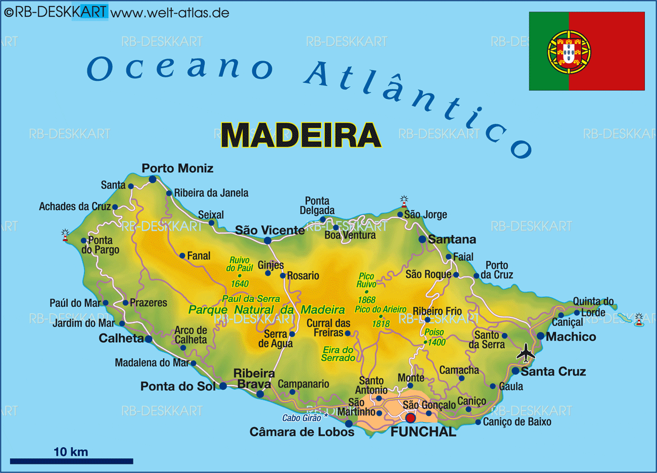
A few facts: Madeira lies 400km north of the Canary Islands and 520km west of Morocco. Its length is a maximum of 35km and width 22km with a coastline of 150km, the population is around 151,000. The Portuguese claimed the island in 1418.
For our first expedition that would eventually see us criss-cross the island all week, we headed west through lots of tunnels until the VR1 ended at Ribeira Brava and turned north into the very impressive Encumeada Pass that appears to split Madeira down the middle with a steep sided gorge. We followed the valley floor road until disappearing into another long tunnel that brought us out on the northern coast at Sao Vicente. There were a small huddle of shops and restaurants and a ‘Madeira Wine Distillery’ which just seemed to contain old local men huddling from the rain and drowning their sorrows very early in the day. As we looked west along the rugged northern coast, the rocky peaks that seemed to rise almost vertically were being pounded by the Atlantic in strong winds.
A series of shorter road tunnels took us west. Originally, before the new road, there was road number 101, a car wide strip clinging to the cliffs just above the raging spray and waves. There are a few sections left, mostly barricaded to prevent exploration, but we managed to get onto a couple of short stretches. Fallen rocks covered the cracking tarmac, and narrow tunnels took us into little hidden hamlets you would not realise were there. Madeira gave the impression that anywhere where it was possible to build houses, no matter the gradient or thinness of ledge, someone would attempt to do so.
Following the main road, we drove down into Porto Moniz whose major tourist selling point were natural pools made of volcanic rock. On a windswept rainy day like today, there were only a couple of takers braving the plunge. The neighbouring black lava outcrops looked very impressive, with the waves battering them and the spray flying upwards.
Backtracking eastwards a few miles we found a narrow turn off (ER209) into the hills marked ‘Fanal’. We were on the search for Laural Forest (Laurisilva). As we climbed a narrow twisting road up into Madeira Natural Park, the mist/clouds descended. It made for a very atmospheric drive past flowering gorse bush.
Eventually we came across a muddy car park with some cars and people milling around. We had hardly seen a car since leaving Porto Moriz. It didn’t look like a UNESCO Heritage Centre. We had come to see “An Outstanding relict of previously widespread laural forest type. It is the largest surviving area of laural forest and is believed to be 90% primary forest… It contains many endemic species such as the Madeiran long toes pigeon.” (UNESCO) The laural trees were shrouded in mist and looked outer-worldly with wind blown branches cowering in the same direction and their dark silhouettes set against the white mist.
Further on, we started to pass cows, the only cows in Madeira apparently. We entered a large flat plateau area of treeless moorland known as Paul da Sierra. When the mist occasionally lifted, we could see the autumn colours of the low-lying vegetation set against the white wind turbines.
En route, we had also spotted our first ‘levadas’. This is the irrigation system which is the lifeblood of the island to replace the lack of rivers. Two metres of rain can fall in the north while the south is often dry. You wouldn’t know that this week. But the levadas channel the water off the mountains to where it is needed. An impressive series of footpaths and trails has been built next to the levadas. It would have been nice to walk some of these but pounding around misty hills for the sake of it did not appeal.
Returning back to the Encumeada Pass, we headed south to check out Ribeira Brava. This was a nice coastal town with a lovely black and white church and a nativity scene by the promenade. A large river run away lied one half of the town ready for any floods coming down from the mountains.
The following day, I headed back to Azul Divers. The dives were on. Half a dozen of us put on our gear and walked down to a concrete step and swam out to the dive boat that couldn’t moor to the rocks. Passing our gear up, we then climbed up onto the inflatable. For the first dive, we headed east past Funchal and a large cruise ship moored at the Marina until we reached some cliffs on the outskirts. T-Reef was a dive around two volcanic cones sticking up from the seabed. The visibility still wasn’t good, and I was rusty after a three year layoff as we descended to 25m. Silver barracuda darted around. Other than that, I saw nothing special. I was just glad to get below the waves again. The sea temperature was 20’c which seemed warmer than the weather above. Back in the secluded area, we had to swim back from the boat to the steps.
In the afternoon, we repeated the procedure, but this time headed west past Camara de Lobos and moored beneath Madeira’s highest cliffs (580m tall). We followed a moor line down to 23m where we found the Alfonso Cequira Cruiser. This boat had been modified for divers and then sunk here in 2018. It was a nice dive, swimming through much of the boat. In the small bridge I could still pick up the telephones that were there. It more than made up for the morning dive. I missed the diving in the warmer seas, but it would prepare me for the Galapagos Islands in the spring.
On Day 4 (Friday 26), we headed up to Monte which lay 500m above Funchal. This is where the old aristocratic families built their summer villas to cool down in the summer. There are a few botanical gardens on Madeira but we had decided to do just one, the Monte Palace Tropical Gardens. The drizzly rain seemed to fit the tropical scenery even if I had been hoping for some sunshine. We started from the top entrance. It seemed a strange mish mash of stuff. First there were a large room of African carved sculptures, then another room of rocks and crystals. As we descended the ‘gardens’ using steps, ramps and bright orange bridges, the Japanese/Chinese emphasis started to appear with stone pagodas, sculptures, and a line of colourful warriors. It was an interpretation of oriental themes rather than a full-blown Japanese one of raked sand, rocks and manicured trees. There were some Koi fish. But as the drizzle stopped, it was nice to explore at our leisure with a modicum of other visitors. Further down was a large waterfall, pond, fountains and grottoes and the original hotel that was here before the gardens.
Leaving some extreme road gradients in Monte, we climbed up further inland to a crossroads at Poiso (1413m) and headed for Pici Do Areeiro. At 1818m this is the third highest peak in Madeira and the highest you can drive on the island. “On a clear day the views here are simply stupendous” (Lonely Persons Guide). We would attempt these views three times over three different days but barely made out the nearby summit and the Portuguese Air force radar station in-between the thick mist, down pours, hail stones and wind (Choose a climate and rotate every 10 minutes)
Back down the road and at the treeline, famers/shepherds were rounding up their sheep and lambs, many of them black. The forests had lush red and orange autumnal colours. At Poiso, we crossed the crossroads and headed for the northeast coast. The first sight at 880m was Riberio Frio (Cold Village) where a series of waterfalls lay along a twisting footpath. It was pouring with rain and I was happy to see those nearest the road and still return soaking to the car.
We were looking for Sao Roque Do Faial, but the normal road had been closed due to a landslide. I had been watching our fuel gauge drop towards ‘reserve’ with all the steep inclines that we had been tacking and now we were flying blind with no knowledge of the next garage. Eventually we found Faial cowering under the massive ‘Eagle’s rock’. There was no garage. Asking a local man who was cutting sugar cane, he indicated fuel at Santana or Porta da Cruz. But there were no signs to either. I followed my nose to coast where we found a main road and a sign to Santana via a long tunnel. It was a relief to fill up.
Santana had been on my list of sights to see the thatched ‘A Frame’ cottages. These small, triangular and colourful houses represent a part of Madeira’s heritage dating back to when it was first discovered. Made of wood which was cheap and abundant and straw roofs from the cereal plantation, the high slope of the roof allowed the rainwater to drain. Inside, the temperature was balanced. There was just a ground floor for the kitchen and bedroom and small first floor attic to store agricultural products. There were half a dozen of these houses painted in red and white near the town hall (not sure if they had been moved here and renovated), but we saw others dotted around the town which were definitely still inhabited.
The following day (Saturday), we decided to explore the southern coast so it was back to Ribeira Brava and then following the twisty coast road via few tunnels. Calheta seemed under whelming with another artificial beach and we headed inland to Prazeres (meaning ‘Pleasures’). There were various groups of people standing that would peer at us as we drove past and lots of advertising signs for ‘Coral’ the local lager. At Prazeres, we took in the attractive ’Our Lady of Neves’ church before asking a policewoman what was going on. It was a rally car event. ‘Rally cars are very popular on this island’. We had just driven along part of the route. The main roads were closed at midday, but we made sure we could escape via the back roads. The lead car came honking past in advance before the rally cars would come past every five minutes of so. It was a little anti climatic to see each individual car come past oblivious as to whether it was faster or slower than the others. After half a dozen, we decided to move on. The biggest challenge was trying to get out of the village without being cut up by a rally car.
Finding the turn off for Paul Do Mar we followed a steep, twisting narrow road down the cliffs. Beneath we could see the coastal town of less than a thousand population, perching on a ledge under the high cliffs. Until this road was built sometime in the Twentieth Century, it was only accessible by boat. The views down over the town were spectacular. The church could have done with a lick of paint. At the far end was a bronze sculpture ‘Man of the Sea’ looking out at the, er, sea. We took a narrow tunnel under the cliffs to Jardim do Ma (‘Garden of the Sea’). Supposedly popular for surfing (we saw no one), the two hundred strong village it had more pebble beaches but did have a decent coffee shop.
Ponta do Pargo (‘Red Snapper Point’) further up the northwest coast was a pleasant surprise. We followed the sign not realising what it was until we came across a red and white striped lighthouse. This was the most westerly point in Madeira and the views along the cliff edges and sapphire coloured sea were wonderful. With near vertical drops, you didn’t take very long to peer over. That was the enjoyable thing about Madeira. Rather than follow a guidebook, we just took a turning to see what was at the other end.
Just before Porto Moriz, we took the ER110 climbing back up to misty plateau and cows on the road. This was a different approach to the one that we had done on our first day and looked the same. When we reached the treeless moorland of Paul da Sierra, it was even more enveloped in the mist. Back at the Encumeada Pass we headed north back up to Sao Vincente and took a right at the coast to tour the bleak cliffs being smashed by a rough Atlantic Ocean along the coast to Santana, thereby completing a full navigation of Madeira’s coastline.
We continued onto the far south east and ended up in Canical which had a nice church and whose coastline was being battered by the Atlantic. Nearby was Machino, Madeira’s second ‘city’ which was where the explorer Zarco first stepped ashore to claim Madeira for Portugal. There is a white sculpture of Zarco near the artificial beach. If you are looking for sandy beaches, Madeira is NOT the place to come. The only ‘beaches’ are piles of volcanic rocks in secluded bays and not exactly comfortable enough to lay your towel out for a some suntanning. I had been surprised at this. The guidebook would describe beautiful coastal villages and my first reaction was ‘where’s the sand?’ Machino’s artificial beach was the best we saw all week.
The following morning after heavy downpours we returned to Monte which had massive rainbows in the Valleys and a second attempt to see the Pici Do Areeiro. But the mist was even lower than before with no views and we took a sideroad which took to the Eiro do Serrado viewpoint, 1094m above sea level. Despite the miserable weather, the views down to the town of Curral das Freiras were spectacular. We then drove through a tunnel and down to the town which was located at the bottom of a huge cauldron of rock (where the lookout was). The valley was known as ‘Nuns Valley’ because legend has it, a group of nuns moved up from the coast into the valley to hide from pirate attacks. The town was also known for chestnuts and the local cuisine offered chestnut soup, cakes, and biscuits. From here we traced a minor road up a cliff until it just stopped. Many roads in Madeira were dead ends when they couldn’t build any more houses.
Back down on the coast, we explored Funcal, the capital for the first time, driving along the promenade. To be honest, there was nothing here that I was interested in seeing. A series of narrow lanes took us upwards to a twisty road that lay on the edge of the cliff with steep drops down to the sea. There was a nice lookout point where you could look back over the entire capital and bay.
Back on the VE1 dual carriageway, we saw a sign for the cable car and followed the signs. There are two cable cars up to Monte. This was the shorter one from the Botanical Gardens. The cable cars were half empty. We boarded one and admired the views below of forests and waterfalls. Ten minutes later we got off, had our packed lunch and got back on again for the return ride. It was a bit underwhelming when you have done some major ones in Europe.
Our final stop was the attractive seaside town of Camara de Lobos which lay at the bottom of the road to our hotel. Driving down to the harbour, we parked up to admire the views of the cove and black volcanic rock. From here I could also see where I had dived in front of the towering cliffs a few days before. It had been a nice relaxing Sunday where we had discovered places we didn’t know about.
On our final full day, there was a third attempt to see the view at Pici Do Areeiro, but the weather was the same. Mist that never lifted and drizzle. No matter. The one good thing about Madeira was that the distances were not vast. I think the journey was about 40 minutes from the hotel. The autumn red and orange colours of the trees looked wonderful as sheep and lambs grazed on the grass. We decided to give the far south east another go. After an excellent coffee at Canical (it was always a bit strange that when we re-visited a town, we would find a different part that we had not seen before), we made for the peninsula that sticks out in a thin line of volcanic rock. I’m still not sure what it is called.
From Canical, we followed the road until it ended and found a parking area full of cars and tour buses. There was a pleasant walk over the hills to Ponta do Castelo, the highest outcrop. At the bottom, was the Atlantic Ocean pounding the base of the cliffs. Today, the weather at sea level was wonderful and sunny and it was the most attractive part of Madeira we saw. En route, the off-shore islands of Porto Santo could be seen in the haze. A turn off further back from the car park took us to the Miradora de Ponta Rosa (Miradora means ‘lookout’). This was a spectacular view down over a large cove surrounded by twisted orange rocks and lots of eroded rocky pinnacles sticking out of the ocean. We were so glad we had made another attempt to find this area and see it in fine weather. If only the mountains had provided the same.
That evening, we had a final dinner at a restaurant in Camara de Lobos – with melon/ham and huge mussels as starters, garlic bread and pepper steaks for the main with cheesecake to finish and washed own with Coral beer. It was the best meal we had all week.
While we were in Madeira, Boris Gump our Prime Minister had decided that lateral flow tests were no longer good enough and PCR tests were required upon return, so we had to organise those and complete a lengthy Patient Locator Form for the men with their clipboards.
Everyone raves about Madeira and it is a nice island with lovely friendly people. I realise that we hadn’t seen it at it’s best but felt that we had a very good understanding of what it had to offer. If you love walking, seafood and a relaxed break, Madeira is for you. It had been great to get away after two years and we returned feeling refreshed and that travelling was once again possible.