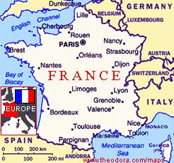
Enduring The Jura Mountains, France
July 1994
Friday July 15th
We flew to Lyon on the 7pm Air France shuttle and picked up our Eurocar rental - a Renault Cleo with 7 km on the clock. Since it was already dark and about 10pm local time we opted to find a local town which turned out to be St Laurent de Mure. At the Hotel de Savoie we found a room for 149f and cold beers "pression" on the patio.
Saturday July 16th
We took off early through fields of sunflowers along the N85 southwest towards Grenoble. At Sassenage we raided a hypermarket for lucheon goodies before entering the Parc Naturel Regional Du Vercors. The idea was to use the relatively gentle Vercors massif to get in some walking. The Vercors measures 40 miles from north to south and 25 miles from east to west. More than half the region is covered by forests pine, larch and beech trees, but there are many large clearings in the woods as well as wide open spaces in some of the upland valleys. We drove up the wide valley "Gorges d'Engins" of the Bourne towards Villard-de-Lans and had lunch en route in the blazing sunshine.
Villard is the tourist capital of the Vercors, and we wanted to base ourselves for the weekend. We found a comfortable hotel for 200f a night and then took off back down the mountain to Seyssinet to climb back up using the Cimes walk Number 4: a four hour round trip to St Nizier, just over the rim of the Vercors mountains. It was not particularly attractive, but pleasant enough to endure the steep climb up through the woods cutting across the main road which hairpinned its way down, half a dozen times. At every stream we made the most of the ice cold water. Up at St Nizier, we had a beer before descending with long views back over Grenoble to the mountains beyond. The walk and heat exhausted us enough to turn in early that night.
Sunday July 17th
The open air market at Villard was full of local sausages and cheeses. It was another beautiful hot day and we decided to explore the rest of the park. We drove on the Pont-en-Royans road into the "Gorges de la Bourne". The gorge became rapidly deeper and narrower with the road cut right in under the rocks, the river running far below, with tree-hung cliffs almost shutting out the sky above. As the gorge opened out, there was a side road up to the "Grottes de Choranche". The limestone rock of the Vercors is honeycombed with subterreanean passages, caves and potholes. The significant feature of these caves is the formation of needle like stalactites, hanging in their thousands from the roof and reflected in the water. Some of them are 10ft long and very thin, but hollow. The special lighting shows them to very good effect and makes them almost appear transparent. They are thought to be unique in Europe. During the hour long tour, we also saw strange primitive life forms - which were like blind worms with tiny paws and legs. Outside the cave we tried to spot buzzards and hawks gliding around the cliffs.
As the road continued towards Pont-en-Royans, it passed through the village of Choranche with its lovely shaded market place. We lunched by the River Bourne where a small dam had created dipping pools which we made the most of. The national park tends to fill up in the summer with tourists but we found the traffic was pretty light, and no area was ever overcrowded. Although the cliffs were still impressively high, the gorge had opened out comletely, and there was a feeling of space until Pont-en-Royans. This town is sited on a very narrow gorge spanned by a single bridge. The most remarkable feature of the town is its houses perched on the rock and in places built into it as they overlook the river.
From this town, we headed for the most famous road in the Vercors, La Route de Combe Laval, which traverses the sheer 2,132 ft cliff face contouring round the Combe Laval and drops into the valley at St Jean-en-Royans. The views were spectacular with only a short wall separating us and a 2,000 drop. We had to negotiate narrow tunnels to get around the cliff, using the horn contantly to warn any oncoming motorists. The Vercors, because of its natural defences and geographical position was isolated from the main theatres of war, and the Resistance movement used this isolation in order to build up the area as abase from which to operate but were eventually defeated. We passed though the sleepy village of Vassieux which had been the centre of the resistance.
We then followed the "Col de Rousset" road through woods of pine and fir, down the steep twisting descent to Die, with terrific views of the white crags and pinnacles of the southeast end of the massif. At Die, we stopped to try some ice cold wine tasting - the local bubbly white wine called "Clairette de Die". South along the river Drome, we came to the Pont de Quart and forked left for Chatillon. Chatillon, a lovely village in a narrowing valley bottom was surriunded by apple and peach orchards, vineyeards, walnut trees and fields of lavender. In the early evening, we stopped for more swimming by the bridge where a weir allowed us to body surf. From here on, the road entered the narrow sunless trench of the "Gorges des Gas", winding up between sheer rock walls to Grimone. After a day of narrow, twisting roads, it was a relief to reach the a fast main road which took us back to Grenoble and up to Villard-de-Lans.
We were delayed by late sunday traffic near the city. I had hoped to watch the World Cup Final in a French bar, but we found no interest, and settle for a cheese fondue and wine before retiring to our room to watch the second half. The very active day, led to me sleeping through the whole match. I never did find out the result. I also managed to loose my watch behind the shower console, which means that an alarm will go off at 6am in that room until the battery runs flat.
Monday July 18th
It was time to head north to the "Parc Naturel Regional de Chartreuse". We skirted around Grenoble, with no desire to enter the centre. Grenoble lies in the valley of the River Isere which separates the two limestone massifs. The Chartreuse massif does not cover a very large area. It is only 25 mile long and 10 miles wide. It is cut off by surrounding valleys in such a way that it has a sense of isolation from the surrounding mountains. Our first destination was the 100 year old "Fort du St Eynard". A very narrow lane took us up through the woods to the top of the massif. The view from the fort was very wide, with Grenoble laid out below and the snow covered Oisans and Obiou massifs beyond. we explored the area surrounding the fort, full of colourful wild flowers and butterflies.
We stopped for lunch somewhere, en route to "Charmont Som". Although the road is very steep in places, it gains so much height that from the end of the road, it was only a half hour walk to the top of the mountain. We hiked up to the top of the grassy hill (1867m) for a view over the white limestone outcrops and further north to the "Monastrere de la Grande Chartreuse" surrounded by forests. The isolated nature of the massif was the main attraction for religious people and the monastry was started in the 11C. The monks invented the drink "Chartreuse" - a green or yellow liqueur made with mixed from the region. We hoped to walk around the area the following day. Right in the heart of the massif, we found the village of St Pierre-de-Chartreuse and booked into the "Hotel Du Guiers". This looked pleasant enough from the outside, but was run down inside. It was situated on a gushing stream and the bedroom window view was lovely. We drove down the Gorges du Guiers Mort to St Kaurent du Pont for shopping. Soon after we returned to the hotel, it began to pour with rain, and did'nt let up all night. We ate at the hotel and tried the "Chartreuse" liqueur by the river - at an extortionate price (50f each). The bed was so uncomfortable, we slept on the floor and had stomach pains throughout the night. We were miserable.
Tuesday July 19th
It was pouring with rain, we both had food poisoning, and the mist/rain meant any walk around the forests to look over the monastry would be pointless. We decided to head north to the Jura mountains early, and try and flee the rain. We both felt lousy. We returned to St Laurent du Pont to find the main road to take us north to Chambery. It continued to rain all morning. Chambery was the major town of the area, but we weren't feeling like walking around. We found the famous "La Fontaine des Elephants" - a monument of four elephants erected in 1838 to a local who made a fortune in India and spent it on Chambery. We roared north past Aix le Bains on the Lac du Bourget and decided to try Annecy, which had a good reputation.
The guidebook said "Annecy is a town that has everything. It has charm, character, history and is set in a beautiful site surrounded by mountains at the end of what is claimed to be the cleanest lake in Europe". What we found was a city with gridlock in the rain. Awful place. We headed for tour of the lake and looked for cheap accomodation to perhaps ride out the illness. But the traffic was horrendous. Huge trucks roaring past with deafening noise. The lake looked pleasant enough and clean, but mist shrouded the surrounding mountains. We drove right around the lake down the east side south to Doussard and turned north. There didn't seem very much cheap accomodation or anywhere that looked special so we kept going. Around Duingt we got out for a walk during a rain stop, but we still both felt awful.
Deciding to cut our losses, we opted to drive to the start of the Jura and see where we ended up.This turned out to be Nantua via Bellegarde. Nantua was a smaller version of Annecy without the traffic. We drove around the small lake, but exploding bowels forced us into an expensive hotel "L'Embarcadere" right on the lake. It was an ugly modern hotel, but very comfortable with large bath, TV and hard bed. Just what we needed to get over the food poisoning. There was an excellent restaurant which we never even entered.
Wednesday July 20th
The next morning, it was still raining. Walking into town we had coffee and croissants for breakfast. Not much to see, so we were off to the lake region of the Jura. We drove past Oyonnax and Moirans. Both non descript. We found an excellent scenic view of the Lac de Vouglans - a long wide lake almost turquoise in colour surrounded by forests and with large groups of buzzards and hawks swooping over them. An outstanding beauty, the (third largest) manmade lake was created in 1968 when the Vouglans Dam was built. It had stopped raining. The sun had finally come out. Our illness was gone and we were back on holiday. We turned left at Bonlieu for the Cascades du Herisson. The river Herisson drops down from the plateau in a very impressive series of waterfalls. The place was filled with Dutch tourists. We walked down through the woods past a series of falls - the Eventail (the Fan), the Gour Bleu, thye Saut de la Forge and the Saut du Moulun, one of which we walked under, until we reached the Grand Saut - the Great Leap, where the water drops 197ft directly from the top of an overhanging cliff to the rocks at the bottom. It was lovely and sunny and we were starving.
We had lunch at a small restaurant outside at Chaux du Dombief. To walk it off we drove to the Pic de l'Aigle, a peak of 2,995ft, and the best point from which to see how the Jura is shaped with its valleys, its plateau and to the south its moutains. After clambering up to the top, we drove north to Champagnole, a large market town, to pick up a series of walks around the area in the forests. Heading west we made our way to Baume les Messieurs, one of the most pictureque villages in France. In retrospect, this turned out to be the most scenic place we saw all week. It was originally a religious enclave and the abbey is still there. As we descended into what seemed like a secret valley, surrounded by overwhelming cliffs, we could see the church and abbey. Since it was late afternoon, the village was relatively empty. We explored the abbey had a beer in the glorious sunshine. After exploring the valley we drove back up to the top of the cliffs to get a view of the whole valley with forests covering the horizontal white plateau of limestone.
Relatively near, Chateau-Chalon was an originally afortified castle on the rocky spur overlooking the foothills and the palin of Bresse beyond. It still has the 11C church that overlooks the vineyards below. It was now a wine destribution centre catering for the tourists and marketing the yellow "Cotes du Jura" wine. We visited a winery and were taken to a cellar where we tried the local wine "Vin Jaune de Chateau-Chalon", a very expensive brand, and settled for something cheaper. It was getting late, and we knew of nowhere to stay. We tried the local village of Voiteur with no success. We drove north to Poligny the nearest largest town and found a wonderful old pension built in the 17C. "Le Mottarone" was very cheap and had character. It also had a cheap restaurant on the outside terrace next to the church. We ate a late dinner and watched bats swoop down from the belfry. The owner was very friendly. We decided to stay another night and explore the area.
Thursday July 21st
We pottered around Poligny which had lots of character and old buildings and found the decorative Hotel de Ville. After almond croissants for breakfast, we drove out to Arbois (wine distribution centre) where Louis Pasteur was born. We saw his house and statue during our explorations. We walked down by the river, and did some food shopping. Then out to the edge of the plateau to the east of the town to see the Cirque du Fer a Cheval, the Horse Shoe. Here the plateau has been eroded away in many places to form an amphitheatre, which takes the form in some places of a cliff as high as 750ft.
Salins les Bains was next on the list. In the middle ages this was a very important place due to its salt mine. The owner of the mine became the weathiest man in the area. The 1718 Hotel de Ville was again impressive. Arriving at lunchtime, we found both the saltmine and the spa closed. The town was also an important staging post between Burgundy and Switzerland. Consequently, there are forts on either side of the valley. At lunchtime we drove up to Fort St Andre for a meal looking over the valley. Then back for a tour of the mine. The Salines, the salt works, have been a museum since 1966. The underground gallaries, 1315ft long and constructed in the 13C to protect the salt springs, are very impressive. The salt is very deep (820ft), and has to be extracted in the form of brine. This was done by an ingenious system of pumping water down to dissolve the salt and then extracting the salt laden water. When it came to the surface it had to be heated for the water to evaporate,leaving only grains fo salt. It was a comprehensive tour and very interesting.
We continued all the way to the regional capital Besancon. Parking near the "Porte Noire" (a Roman Triumphal arch constructed in 2nd C with military and mythological themes) whose bas-relief was suffering from car pollution, we walked to the Cathedrale St Jean and up to "La Citadelle". This is a massive fortress built by Vauban in 1674 for Louis XIV, 387ft above the town. Nowadays it houses numerous museums, and the area was full of french schoolchildren on visits. We contented ourselves with a walk around the overwhelming walls. The overall impression is of solidarity and strength of the complex. Back at ground level, we popped into see the "Palais de Granvelle", a perfect renaissance building constructed in 1540. The interior courtyard is particularly fine with its cloisters and elegant archways supporting the beautiful roof. Our visit was fleeting, and we saw the 16C Porte Rivotte as we left for Ornans.
About a mile before Ornans, in the village of Cleron, there was a castle on the banks of the River Loue that was built in the 14C to protect the salt route from Salins-les-Bains. It is a good example of a fortified castle in this region with its red-tiled central tower and circular donjons. There was a lovely reflection of it in the river looking upstream. Ornans was again supposed to be a "lovely little town", but we found most of it generally non descript and traffic clogged, except for the view of the houses on the river Loue. We had a beer and watched the river flow past. Back in Poligny, we had another excellent meal on the terrace and considered the northern Jura towns well and truely visited.
Friday July 22nd
We started the day by walking around the remains of the medieval ramparts of Poligny. Up a steep wooded cliff to look over the town, followed by a walk around the oldest houses in the town. It was the most pleasant town we were to stay in. Heading east, we wanted to explore the Fort de la Joux and skirted Champagnole. The Foret de la Joux is a huge forest, mainly of pine with many hamlets and villages in and around it. We followed "La Route des Sapins" which gives access to the most interesting and impressive sections of the forest. Eventually, we started a walk up through the woods to see the "Sapin President", the tallest tree in France. The king of the Forest is a fir tree which stands at 148 ft hign and is reckoned to be over 200 years old. It was a lovely two hour walk with blueberries everywhere and the sun peeping through the canopy of trees.
We drove to Lac de St Point for a picnic and a swim. We noticed that the Tour De France was passing through the next day. Time to head north of Pontarlier up to Morteau, en route to Eschelles de la Mort. We followed a river north to Morteau and tried a small town called Villers de Lac, but both hotels were full. In Morteau we stayed at the poshest hotel "La Guimbarde", slightly run down, but very comfortable with a marvellous old lounge.
Saturday July 23rd
The whole day was to revolve around the Tour De France. We drove to the Swiss border and down into a scenic valley to climb the "Echelles de la Mort". This was a smugglers route on the frontier with long wooden ladders dropping down the cliffs. We walked up the trail and climbed two lengthy (metal) ladders for a spectacular view down the forested gorge. A group of 6 English girls puffed their way down with backpacks. Back at the border we drove along some scenic roads in Switzerland down to Neuchatel and along a motorway west back into France.
We arrived at Lac de St Point about 15 mins before the Tour de France cavacade started past. Since we were on a bend, we were fortunate to grab some of the goodies that got thrown out at us. We could see right across the lake with our binoculars and could see the cyclists approaching. The crowd around was sizeable and in good humour. It was all over in a flash. They came past in a large group followed by the support vehicles. After the race, we had a beer in the local bar. In and out in two hours, we drove towards Pontarlier and hit the whole tour regrouping for the drive to Paris. Police escorted groups down the middle of the road.
We decided to explore the hills. First we drove up Grand Taureau (4,340ft), the tallest hill in the Northern Jura but didn't get much of a view. Back down the road we walked to the fort and got a lovely view along the "La Cluse-et-Mijoux" valley and across the road to the Chateau de Joux which acted as a guardian over the lines of communication south. There were lines of Tour traffic along the valley. We cut across them through golden fields flooded in dusk sunshine towards Nozeroy. We spotted a sign to a hotel at Censeau and pulled off a few miles from Nozeroy. The Hotel Central was in a tiny village. Our room overlooked a pissoir across the road. The room was basic but cheap and comfortable. In the restaurant we treated ourselves to a slap up meal. Steak again and a good bottle of wine. In the middle of the night, we went down with food poisoning again which was entertaining for an hour or so (not).
Sunday July 24th
Arriving in Nozeroy around 10am we discovered that there was a Medieval fair happening. Nozeroy was the home of the Chalons, the most powerful family in the Jura in the Middle Ages. It used to be encircled by ramparts with a magnificent fortified gateway. This still exists as the Porte de l'Horloge. The grand Rue maintains the atmosphere of the middle ages with its ancient houses of warm coloured sandstone. More so today, as long tables were set up along the street for the feast. An entire cow was being roasted on a spit. Locals dressed in medieval costumes. We explored the town for a couple of hours when it was still relatively empty. Since we has a busy day, we decided to leave before it really got going.
We drove to Champagnole and south to Morez for a view over the plains across to Switzerland. The Tour de France had passed through yeaterday and the roads were covered in graffiti. Morez was the chief ski resort, relatively empty on this scorching day. Anyone with sense was down by a lake. Taking a small twisting road, we made our way to St Claude passing through beautiful gorges down to it and crossing a high level bridge over the River Tacon. The sizeable town was empty. We pushed on to the Lac de Vouglans for an late afternoon of sunbathing and swimming. The lake was full of tourists but we found a tiny stretch of sand. As the sun started to drop we started to look for a hotel. There was nothing around. Finally we discovered Orgelet and the Hotel de la Valouse. Very grandiose with a restaurant out of our league this late in the holiday.
Monday July 25th
We explored Orgelot, an attractive old village with a church tower (that rang throughout the night across the road from our hotel room). The agenda was sunbathing by the lake. This is what we did all day. Reading, swimming, picnicing. That was the day. The beach filled up with topless lovelies. The buzzards soared overhead and the sun was glorious. Around 6pm it was time to finally head south towards Lyon Airport.
The roads were fast and relatively empty. We reached Bourg en Bresse very quickly on the N83 and kept right on to Lyon, where there were no signs to the airport. We got lost in the suburbs, there was a tremendous thunderstorm and the roads started to flood. Finally we found our bearings and ended back at the Hotel de Savoie in St Laurent de Mure.
Up early on Tuesday July 26th for the 7.20 flight back to London.