
| Top |  |
 |
 |
 |
|||||
 |
|||||||||
| Mt. Rainier -- Emmons/Winthrop
Glacier route, Jun '00 Devil's Tower -- The "Classic" Durrance route, Jul '00 Mt. St. Helens -- The "Standard" Monitor Ridge route, Aug '00 Mt. Rainier -- Training climb to Ingraham Glacier, May '01 Mt. Rainier -- Tahoma Glacier route, Jul '01 |
MT. RAINIER -- EMMONS/WINTHROP GLACIER ROUTE, JUN '00 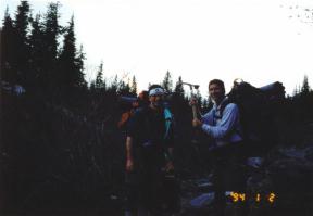 Gary, Jim and I started the
Emmons/Winthrop
route at the White River Parking Lot which is approx. 7 miles in a straight
line to the summit of Rainier, not including the 10,010 ft. elevation gain and
the twists and turns of the trails. Mt. Rainier is right behind Gary and Jim,
but the sun was too bright for it to come out in the picture. The moron behind
the camera also forgot to change the date on his camera . . . it wasn't Jan. 2,
1994. Gary, Jim and I started the
Emmons/Winthrop
route at the White River Parking Lot which is approx. 7 miles in a straight
line to the summit of Rainier, not including the 10,010 ft. elevation gain and
the twists and turns of the trails. Mt. Rainier is right behind Gary and Jim,
but the sun was too bright for it to come out in the picture. The moron behind
the camera also forgot to change the date on his camera . . . it wasn't Jan. 2,
1994.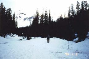 The hike to our first camp at Glacier Basin was a relatively easy three hour hike over snow and dirt. We started in the evening on Friday to get better acclimatized before our Saturday climb to high camp, Camp Schurman, at 9,510 ft. 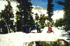 After waking up "late," around 7 a.m., Gary packs up our first camp while the guy with the camera does absolutely nothing to help out :). To the left of the rock peaks above Gary and inbetween the trees is where we'll be heading up and over to Camp Schurman. 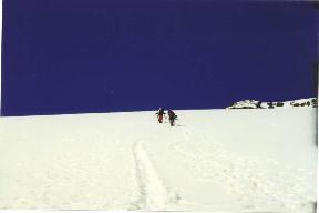 This shot is of climbers above working their way up the steep slopes of Inter Glacier. It was a beautiful warm, sunny day. The sky was incredibly dark blue. I'm tired of reading and want to go back to the top 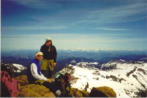 High on Inter Glacier was a rock outcrop, a perfect place for a break. We are at about 9,000 ft. above sea level at this point. The views were excellent. It is hard to see in this picture on the web, but to the right of Gary on the horizon is Mt. Hood, which is over 100 miles away in Oregon. We could see it clearly from where we were. 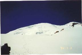 After taking
the shot of Jim and Gary above, I turned around and took a shot of the summit
curve of Rainier. The section of glacier that is seen in this shot is the
Emmons Glacier. Directly up the middle is our route to the summit. We looked
carefully on the route below the summit and could see small black dots slowly
working their way up. The summit group had almost made
it. After taking
the shot of Jim and Gary above, I turned around and took a shot of the summit
curve of Rainier. The section of glacier that is seen in this shot is the
Emmons Glacier. Directly up the middle is our route to the summit. We looked
carefully on the route below the summit and could see small black dots slowly
working their way up. The summit group had almost made
it.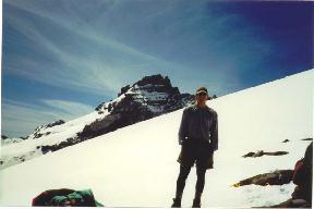 Wow! Who is this hottie? He's a fine looking mountain goat! Anyways, that's me on the same rock outcrop with Little Tahoma in the background. Little Tahoma is an elevation of 11,138 ft. Notice the angle of the slope behind me, that is nothing compared to what we'd face higher on the route. 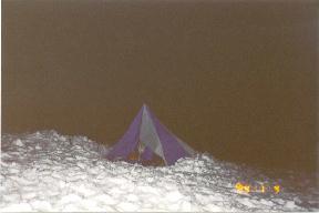 After a brief evening's sleep at Camp Schurman, we are up at the butt-crack of midnight, ready for our push to the top. Jim couldn't get over how we were sleeping at 9,510 ft. in the freezing cold, on the snow and in a tent with NO FLOOR! This, however, was like a five star Hilton to Gary who has been known to sleep buck-naked in Montana snowcave's just for the fun of it!! :o) 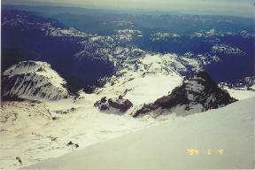 After
eventually reaching the summit through a cloud cap storm (of which I have no
pictures because you could barely see 10 ft. in front of you and the wind was
blowing about 40-50 miles per hour), we carefully decended the steep upper
slopes. This shot was taken at about 13,000-13,500 ft., maybe higher? We
actually started to head back down before reaching the summit because we were
the first group up that high and we had no wands with which to mark our trail.
But then a group of four or five guys came with wands and let us
follow. After
eventually reaching the summit through a cloud cap storm (of which I have no
pictures because you could barely see 10 ft. in front of you and the wind was
blowing about 40-50 miles per hour), we carefully decended the steep upper
slopes. This shot was taken at about 13,000-13,500 ft., maybe higher? We
actually started to head back down before reaching the summit because we were
the first group up that high and we had no wands with which to mark our trail.
But then a group of four or five guys came with wands and let us
follow.I've heard enough yapping. Take me back to the top 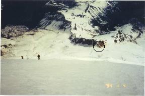 After taking the shot of Little Tahoma above, I turned to take a shot of Camp Schurman (which is circled and is at an elevation of 9,510 ft). We were up there a ways! Also, note the steepness of the slope by looking at the two guys below to the left. 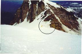 It took us a long while to get down to this point about 1,000-1,500 ft. above Camp Schurman. Relaxation is not far away now 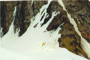 Now we are only 500-1,000 ft. above Camp Schurman. By this point, my physical and mental endurance is just about gone. After climbing for about 15 straight hours (from leaving at midnight to returning to Camp Schurman at 3 p.m.), all you want to do is get back down as fast as possible. 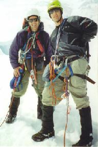 Well, we all made back to Camp Schurman o.k. We took a brief nap and
with a huge, throbbing headache, we continued down to the White River Parking
Lot. The snow of Emmons and Inter Glaciers turned to mush in the late afternoon
sun. We had a hard time continuing down due to fatigue and plunging thigh deep
with each step into the slushy snow. Well, we all made back to Camp Schurman o.k. We took a brief nap and
with a huge, throbbing headache, we continued down to the White River Parking
Lot. The snow of Emmons and Inter Glaciers turned to mush in the late afternoon
sun. We had a hard time continuing down due to fatigue and plunging thigh deep
with each step into the slushy snow. As Jim and I were slowly running down Inter Glacier we thought all our worries were behind us when I suddenly slammed on the brakes before stepping into the black abyss of a foot-wide, 30-foot long crevasse!!! It is rare that crevasses open up on Inter Glacier and it wasn't there the day before when we were going up. I briefly looked into the crevasse seeing that it went down about 30-40 feet and then quickly jumped over. Needless to say, my heart skipped a couple beats. We arrived back at the car around 6:30-7 p.m., which means we had been climbing for around 18 hours. Gotta love mountain climbing. Back to the top |
||||||||
