
< 26 to 37 | Home | 51 to 75 > |
Photo: |
|||||||||||||||||||||||||||||||||||||||||||||||||||||||||||||||||||||||||||||||||||||||||||||||||||||||||||||||||||||||||||||||||||||||||||||||||||||||||||||||||||||||||||||||||||||||||||||||||||||||||||||||||||||
|
|
|
| ROUTE LOG |
US 360 Bus: 0 - 0 VA 153: 7 - 7
|
Creation: Appeared in July 1933 as the 2nd VA 38. Ran from US 360 Amelia to US 460 Sutherland, with a small break between Namozine and the Amelia-Dinwiddie County Line. This was a renumbering of part of VA 406.
| Adjustments: VA 38 was made continuous by July 1936. VA 38 west was extended along current SR 681 to VA 13 Tobaccoville in 1940-41, replacing part of VA 49. In 1952-53, VA 38 east was truncated to 3 miles south of Scotts Fork (leaving a useless multiplex with VA 153), leaving behind SR 708 to Sutherland. Between 1954-56, VA 38 west was truncated back to US 360 Amelia, leaving behind SR 681 to Tobaccoville. The useless VA 153 multiplex disappeared between 1958-61. Posting: Fully posted. Comment: Drove this in October 2001. Not much excitement to it. | Previous VA 38's: |
VA 38 #1: Appeared in 1923, running from VA 31 (curr US 1) Fredericksburg to VA 30 (curr VA 33) Saluda. This was a renumbering of the original VA 8. This follows the current US 17 corridor, except between New Post and Port Royal, where it followed today's VA 2 to Corbin, then east through AP Hill to Moss Neck to Port Royal (used SR 610 and SR 766?)
In 1927, US 17 existed over this same route. By 1928 VA 38 was extended west to VA 32 (curr VA 28) Bealeton over today's US 17. In 1929, VA 38 was split into 2 pieces by US 17: 1. US 15 Opal (a lengthening west from Bealeton) to US 1 Falmouth and 2. US 17 Saluda to Bayside (this today is VA 33, VA 3, VA 198, VA 14). VA 38 was eliminated in the Great Renumbering II in 1933, The northern piece became VA 17 and the southern piece became VA 4, VA 225, VA 198, and VA 14. |
||||||
|
|
|
| ROUTE LOG |
US 11: 0 - 0 VA 252: 8 - 8 VA 39 ALT: 11 - 19 VA 42 NB: 0.5 - 19.5 VA 39 ALT: 0.5 - 20 BA-RB LINE: 2 - 22 VA 42 SB: 6 - 28 US 220: 13 - 41 WV STATE LINE: 13 - 54
|
Creation: Appeared in 1940-41 in a state line renumbering with its current route, except it went closer to Lexington on US 11. It replaced the 3rd VA 501. This is the 3rd VA 39.
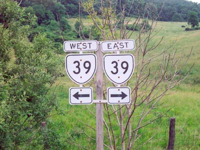
| Adjustments: Not much. Realigned to accomodate I-64 around 1972. Posting: Fully posted. Cutouts in Warm Springs, Lexington (at SR 645 jct) and Goshen (was there until at least 1993 - gone now). Here is a picture from 1992. Comments: VA 39 between Lexington and Goshen is a fine scenic drive. | Previous VA 39's: |
VA 39 #1: Appeared in 1923, running in a zigzag fashion from the current VA 84 crossing into WV to Hampton. It went to Highland, Staunton, Charlottesville, Louisa, Mineral, Ashland, Richmond, Williamsburg, and Newport News. This was a renumbering of original VA 9 except: WV to Highland was new routing (VA 9 had proceeded due west from Highland); Bottoms Bridge to Toano was also new routing (VA 9 followed today's VA 249/33/273/30) Today this is in order, VA 84, US 250, VA 240, US 250, VA 22, US 522, US 33, VA 54, US 1, US 60.
In 1927, US 60 was attached to VA 39 from Richmond to Hampton In 1929, VA 39 east was truncated to US 1 Ashland. A short discontinuous piece remained between US 17-60 Newport News and Fort Monroe (along current VA 143). In 1930-31, the Hampton stub became US 60 (curr. VA 143) In 1932 the Williamsburg Bypass was designated as VA 39 (curr US 60). The rest of VA 39 was eliminated in July 1933 and replaced by all of VA 271, VA 5, all of VA 22, VA 4, and VA 54. VA 39 #2: 39 was quickly reused in 1933, running from US 460 Pamplin City to US 15-360 near Wyliesburg. This lasted to 1940-41, when it was renumbered as an extended VA 47. VA 39B: Mentioned in January 1931 CTB minutes "East of National Cemetery" It is not clear where this would've been. Perhaps US 60/VA 39 used Williamsburg Rd. and 39B used current US 60. |
||||||
|
|
|
| ROUTE LOG |
VA 39: 0 - 0 VA 39, VA 42: 0.5 - 0.5
|
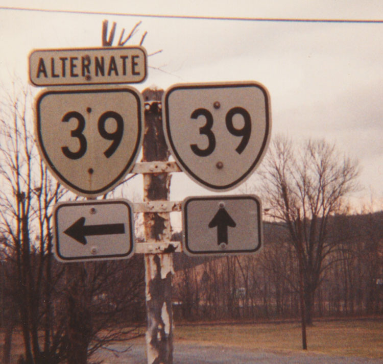
Short street within center of town. Posted with cutouts when I drove by in 1993 (since replacd - I drove this again in October 2001). Here is a picture from 1992. No idea how long this has been around, but this is the 2nd VA 39A.
| | Previous VA 39A's: | VA 39A #1: Mentioned in March 1931 minutes. A partial description included "between North Street in Newport News and the south line of Hilton Village." Today's US 60 does this (Hilton Village is basically where VA 152 ends), as does several other streets. Thus, I do not know where this exactly was. | ||||||
|
|
|
| ROUTE LOG |
VA 8: 0 - 0 FR-PK LINE: 10 - 10 US 220 Bus: 23 - 33 US 220: 1 - 34 VA 122: 1 - 35 PT-FR LINE: 15 - 50 US 29: 15 - 65 US 29 Bus: 1 - 66 HX-PT LINE: 14 - 80 US 501 SB: 11 - 91 CB-HX LINE: 1 - 92 US 501 NB: 1 - 93 CR-CB LINE: 4 - 97 VA 47 NB: 16 - 113 VA 47 SB: 1 - 114 VA 59: 8 - 122 US 15 Bus, US 360 Bus: 0.5 - 122.5 US 15, US 360: 1 - 123.5 VA 385: 0.5 - 124 LU-CR LINE: 0 - 124 VA 49 SB: 14 - 138 VA 49 NB: 3 - 141 VA 137, VA 138: 6 - 147 NT-LU LINE: 5 - 152 VA 46: 5 - 157 US 460 Bus WB: 1 - 158 US 460 Bus EB: a couple blocks - 158 DW-NT LINE: 5 - 163 US 1: 15 - 178 I-85 (exit 42): 1 - 179 SX-DW LINE: 13 - 192 VA 40 Bus: 6 - 198 US 301, VA 40 Bus: 0.5 - 198.5 I-95 (exit 31): 0.5 - 199 VA 35: 14 - 213 US 460: 8 - 221 SU-SX LINE: 3 - 224 VA 10: 9 - 233
|
Creation: Appeared in July 1933, from VA 8 Woolwine to US 15-360 Keysville. This replaced original VA 20 and is the 2nd VA 40.
| Adjustments: By July 1936, VA 40 was extended east to Claremont, on the James River east of VA 10. This replaced all of VA 48. VA 40 east was truncated to VA 10 between 1952-53, leaving behind Sr 646. Posting: Fully posted; there was a cutout in Blackstone in 1993, but as of Sept. 29, 2002 this was found replaced Comment: I have heard that VA 40 west of Ferrum is a seriously twisted route, although there is little elevation change. VA 40 is the longest VA state highway. | Previous VA 40's: | VA 40 #1: Appeared in 1923 as new routing. Ran from VA 10 (curr VA 141) Portsmouth south to NC line heading for Elizabeth City. In 1927, US 17 was assigned this same stretch, which obviated original VA 40 in 1929. | ||||||
|
|
|
| ROUTE LOG |
VA 57: 0 - 0 PT-DAN LINE: 19 - 19 US 29 Bus: 1 - 20 VA 293: 1 - 21
|
Creation: Appeared in July 1933 as the 2nd VA 41. Ran from US 29 (curr VA 293) Danville to 3 miles west of VA 57 Callands. This replaced VA 301.
| Adjustments: By July 1936, VA 41 was extended west to VA 108 (curr SR 969). VA 41 west was truncated to VA 57 Callands between 1948-51. Some recent VDOT maps show a proposed VA 41 extension south to the current US 29 Bypass Posting: Fully Posted Comments: Haven't driven this one yet.... | Previous VA 41's: |
VA 41 #1: Appeared in 1923 as new routing. Originally ran from VA 39 (curr US 60) Richmond to Charles City.
By 1929 VA 41 was extended west to end at VA 39 (curr VA 22) Keswick (eliminated original VA 321 and some new routing), and VA 41 east was extended to Williamsburg (though in 2 pieces - there was a gap between Charles City and Bacon) over new routing. VA 41 was replaced in 1933 in its entirety by VA 5, except near Keswick, which became either SR 731 or SR 619. |
||||||
|
|
|
|
| ROUTE LOG |
VA 91: 0 - 0 VA 16 SB: 9 - 9 VA 16 NB: 1 - 10 WY-BL LINE: 7 - 17 US 52 SB: 20 - 37 I-77 (exit 52): 4 - 41 US 52 NB, VA 98: 1 - 42 GI-BL LINE: 13 - 55 VA 42 TEMP END, VA 100: 10 - 65 US 460, VA 42 TEMP BEGIN: 0 - 65 CG-GI LINE: 5 - 70 VA 42 TEMP END, VA 311: 25 - 95 I-64 (exit 29), US 60, VA 42 TEMP BEGIN, VA 269: 0 - 95 BA-AG LINE: 3 - 98 VA 39 NB: 14 - 112 RB-BA LINE: 4 - 116 VA 39 ALT: 1.5 - 117.5 VA 39 SB: 0.5 - 118 AU-RB LINE: 6 - 124 VA 254: 15 - 139 US 250 EB: 5 - 144 US 250 WB: 1 - 145 RH-AU LINE: 14 - 159 VA 257 EB: 3 - 162 VA 42 Bus, VA 257 WB: 3 - 165 VA 290: 0.5 - 165.5 VA 42 Bus: 0.5 - 166 HAR-RK LINE: 2 - 168 US 33: 2 - 170 RH-HAR LINE: 1 - 171 VA 259 SB, VA 259 ALT: 12 - 183 VA 259 NB: 0.5 - 183.5 VA 211: 1.5 - 185 SH-RH LINE: 5 - 190 VA 263 EB: 6 - 196 VA 263 WB: couple blocks - 196 I-81 (exit 283): 16 - 212 US 11: 1 - 213
|
Creation: Appeared in 1929, and is the original VA 42. It was in 5 pieces then: 1. Mendota to US 19 Holston 2. US 21 (curr US 52)Bland to 12 miles east. 3. Bland-Giles County Line to VA 213 (curr VA 100) Poplar Hill4. 2 miles east of Eggleston to the Craig County Line 5. Sinking Creek to VA 22 (curr VA 311) New Castle. All 5 segments were newly numbered routes.
| Adjustments: In 1930-31, piece 2 was extended west to 3 miles past the US 21 (curr US 52) SB split. In Bland itself, VA 42 was given part of US 21's routing to north of the village (this is part of VA 98 today). Pieces 2 and 3 also became continuous. Piece 4 was extended west to 2 miles west of Eggleston. Piece 5 was extended west 7 miles past Sinking Creek. In 1932, VA 42 was rerouted to hit US 21 just north of Bland. The spur south into Bland became VA 26Y (curr VA 98). Also, piece 5 was extended east 3 miles past VA 22 (curr VA 311) Newcastle. In July 1933, piece #5 was extended east to VA 43 (curr SR 615) Oriskany over an unnumbered route, and pieces 2,3,4,5 were all connected, plus extended west to nearly Smyth County. A 6th piece was added from US 60 Longdale to VA 4 (curr US 33) Harrisonburg, replacing some of original VA 17. A 7th piece was opened as new routing - 7 miles of route east of VA 81 (curr VA 91) Broadford. By July 1936, pieces 2,3,4,5 and 7 were fused together to run from VA 81 (curr. VA 91) Broadford to 4 miles east of New Castle (meaning some of VA 42 was truncated back from VA 43 to SR 615. To recap, VA 42 was down to just 3 discontinuous sections. Section 1 was downgraded to SR 613 between 1948-51. Sections 2-3-4-5-7 were split between 3 miles east of New Castle and Newport between 1948-51. Also section 6 was extended over what was VA 260 to Woodstock between 1948-51. This is where the current VA 42 sectioning comes together. The middle VA 42 section was truncated to VA 311 New Castle between 1958-61. Posting: Fully Posted. Cutouts are up in Harrisonburg and Churchville Comment: This is the only true discontinuous route left in Virginia. The middle piece is quite scenic and rural. Bewtween Bridgewater and Broadway VA 42 is a multi-lane affair and serves as a decent alternate to US 11 or I-81. |
||||||||
|
|
|
| ROUTE LOG |
US 29 Bus: 0 - 0 US 29: 1 - 1 BD-CB LINE: 8 - 9 VA 24 EB: 7 - 16 VA 24 WB: 3 - 19 BED-BD LINE: 8 - 27 VA 122 Bus SB: 0.5 - 27.5 US 221 Bus, US 460 Bus, VA 122 Bus NB: 0.5 - 28 BD-BED LINE: 1 - 29 VA 48, NATL PARK BOUNDARY: 9 - 38 BLUE RIDGE PKWY: 0 - 38 US 11 NB: 5 - 43 US 11 SB: couple blocks - 43 US 220: 17 - 60
|
Creation: Appeared in July 1933 as the 2nd VA 43. Started out as 2 pieces: 1. US 29 Altavista to Leesville (this replaced original VA 320) 2. VA 24 to VA 42 (curr SR 615) Strom (6 miles west of US 220) (this replaced original VA 215)
| Adjustments: The 1944 map shows VA 43 as county road on both approaches to the Blue Ridge Pkwy. Maps 1933-41 showed it as a continuous state route through there. The CTB minutes of October 1938 turn over VA 43 from Bedford SR 641 to Botetourt SR 625 to the National Park Service for inclusion into the coming Blue Ridge Pkwy. Making VA 43 technically a discontinuous route since then. At some point, VA 43 was brought to meet the BRP at its southern crossing, but the 2002 VDOT mileage table still shows VA 43 ending 1.1 miles northwest of Bedford SR 641, which is the Nat'l Park Boundary for the BRP (and referred to as VA 48 in the tables!) Thanks to Chris E for his question that led me to find this out about VA 43... Between 1945-47, all VA 43 pieces were united, and VA 43 west was truncated to US 220, leaving behind SR 615. In 1979, VA 43 was extended north from Eagle Rock to its current end at US 220, replacing a section of US 220 that was routed around Eagle Rock. Posting: Fully posted; Thanks to Gribblenation and Michael Summa, we know that cutouts existed in Bedford until at least 1992 Dan F reports the following posting note for VA 43 in the Eagle Rock area: At the JCT of US 220 and VA 43, there were white rectangles with "043." This is the first case I know of with a leading zero on a route posting. Comment: Coexists with the Blue Ridge Parkway for 5 miles. | Previous VA 43's: |
VA 43 #1: Appeared in 1929 as a new numbered route in two pieces: 1. VA 10 (curr US 221) Forest to Evington, then east to just short of US 170 (curr US 29). 2. VA 18 (curr US 501) Rustburg to US 60 (curr US 460) Concord.
In 1930-31, these two pieces were connected to form an L-shaped route. In July 1933 this was renumbered VA 127 (curr SR 811) between Evington and Forest, and VA 24 between Evington and Concord. VA 43Y: Connector between US 220 and VA 43 over the James River in Eagle Rock, which was once mainline US 220. Was created in 1979 when US 220 was rerouted to avoid Eagle Rock. VA 43Y no longer appears on VDOT maps as of 1998. After the completion of the bridge renovation described below, VA 43Y was renumbered as SR 870 (thanks to Chris E for letting me know the actual SR number here) Information from David Guynn: The 43Y route was closed because of bridge reconstruction. There are only 2 or 3 bridges that cross the James in Botetourt County, and this was one of them. It was a two-lane trestle bridge from possibly the 1940s. VDOT is in the process of rebuilding it, to allow easier access into the town of Eagle Rock, because the bridge cuts a couple of miles off the trip. |
||||||
| VA 44 not currently assigned | |||||||||||||||
| Previous VA 44's: |
44 is the second lowest (after 12) number not in use in Virginia. The area is quite void of 44's, as there is no route 44 in MD, VA, NC, or SC. There have been 3 VA 44's
VA 44 #1: Appeared in 1929: US 501 South Boston to Clarksville, Chase City, Victoria, ending at US 60-501 (curr US 360-460) Burkeville. In 1930 VA 44 was extended west to the Dan River, and a stub heading east off VA 12 (curr VA 360) Danville was created. In 1931 VA 44 was interrupted by US 401 between South Boston and Clarksville (curr US 58), thus VA 44 became a 3-piece route: 1. The stub off VA 12 (curr VA 360) Danville 2. the Dan River to US 501 South Boston 3. US 15 near Clarksville to US 60-501 (curr US 360-460 Burkeville). Sections 1 and 2 became part of US 58 in 1932. Section 3 became part of VA 49 in 1933. Most of the part between Victoria and Burkeville is now SR 723. VA 44 #2: 44 was reused immediately in 1933, running from VA 49 (curr US 522) Jefferson to VA 147 near the curr US 60 jct. This replaced most of the original VA 419. This VA 44 was downgraded to SR 711 in 1952-53. I recently drove this route, and it has the feel of a state route still, and probably should still be one. VA 44 #3: VA 44, Norfolk-Va. Beach Expwy appeared as a dotted line on the 1967 DOT map. It was completely open in 1970, running from I-64/264 to US 60 at the oceanfront. It was a toll road untilthe mid-90's. Renumbered as an extension of I-264 in May 1999 in order to get more federal highway funds for the road. VA 44 remained into 2000. |
||||||||||||||
|
|
|
| ROUTE LOG |
US 15 Bus, US 460 Bus: 0 - 0 US 60 WB: 16 - 16 VA 13: 3 - 19 US 60 EB: 2 - 21 GO-CU LINE: 14 - 35 VA 6: 4 - 39
|
Creation: Appeared in 1929, as the only VA 45. Ran from VA 19 (curr. VA 6) Georges Tavern to 3 miles short of VA 13 (curr US 60) Cumberland. This was previously unnumbered.
| Adjustments: VA 45 was extended south to Cumberland in 1930-31. VA 45 south was extended to US 15 Farmville in July 1933, replacing original VA 310. Sometime after 1961, and before 1991, VA 45 was truncated (leaving behind US 15) in Farmville to its current end, when US 15 was rerouted to be with US 460 as opposed to parallel to it. Posting: Fully posted Comments: I drove this route in June 2001. Between VA 6 and US 60 it has some very twisty spots, but the rest to Farmville is of good alignment. |
||||||||
|
|
|
| ROUTE LOG |
VA 40: 0 - 0 BR-NT LINE: 6 - 6 VA 137: 7 - 13 I-85 (exit 27): 5 - 18 VA 378: 0.5 - 18.5 US 1: 0.5 - 19 US 58 Bus EB: 8 - 27 US 58, US 58 Bus END: 1 - 28 NC STATE LINE: 19 - 47
|
Creation: Appeared in the 1940-41 state line renumbering in its current form, replacing the 2nd VA 34. This is the 3rd VA 46
| Adjustments: None Posting: Fully posted Comments: not much exciting to report about VA 46. | Previous VA 46's: |
VA 46 #1: Appeared in 1929 as a newly numbered routed: A 2 mile stub south off VA 19 (curr VA 6) Columbia.
In 1930-31 VA 46 was expanded to 4 pieces: 1. VA 13 (curr US 60) Powhatan, NW for 4 miles (today this is SR 684) 2. Short stub north off VA 45 Cartersville (part of curr SR 690) 3. 6 mile section with Columbia in the middle (today this is SR 690) 4. VA 39 (curr US 33-VA 22) Louisa, SW 5 miles (today this is VA 208). All of these were unnumbered previously except for piece 3 which included some of the original VA 46 routing. In July 1933 all 4 sections were renumbered as an extension of original VA 16. VA 46 #2: Appeared in July 1933, running from US 15-360 (curr US 15-VA 92 jct) to US 58 Boydton. This was a renumbering of one of original VA 12's sections. In 1940-41 this was renumbered as VA 47 and VA 92. |
||||||
|
|
|
| ROUTE LOG |
US 1, US 58 Bus: 0 - 0 VA 49 SB, VA 92: 22 - 22 VA 49 NB: 1 - 23 CR-MK LINE: 5 - 28 US 15, US 360: 3 - 31 VA 59: 9 - 40 VA 40 EB: 4 - 44 VA 40 WB: 1 - 45 PE-CR LINE: 10 - 55 AP-PE LINE: 4.5 - 59.5 US 460 Bus: 0.5 - 60
|
Creation: Appeared in July 1933 as the 3rd VA 47. Ran only from VA 46-49 (curr VA 92-49) Chase City to US 1-58 South Hill
| Adjustments: Extended to Pamplin City in 1940-41, replacing part of VA 46 #2 and all of VA 39 #2. This however is not the direct route VA 47 uses today. VA 47 ran to Barnes Corner, then up US 15 to the current US 15/360-VA 47 jct. VA 47 was made a direct route in 1980, replacing SR 646. The old VA 47 route is still part of VA 92. Posting: Fully posted Comments: Haven't driven this one yet... | Previous VA 47's: |
VA 47 #1: Appeared in 1929 as a renumbering of VA 323. Ran from US 15-501 VA 20 (curr US 15 Bus, US 360 Bus, VA 40) Keysville to VA 44 (curr VA 49) Lunenburg. By 1931, this VA 47 was renumbered as an extended VA 48. Today it is part of VA 40.
VA 47 #2: Appeared in 1930-31, on an unnumbered road. Ran from VA 117 (curr VA 89) to Pipers Gap. Was renumbered to curr. VA 97 in July 1933. |
||||||
| U.S. 48 |
|
|
|
| ROUTE LOG |
|
This is listed in the VDOT route log published July 2001 as the right of way designation for Skyline Drive and the Blue Ridge Parkway. I have no idea how long this has been designated, but not from the beginning, as some of Skyline Drive was open when the original VA 48 was still around. This would be the 2nd VA 48. The route log makes no mention of Colonial Pkwy or the George Washington Pkwy having a right of way designation.
| | Previous VA 48's: |
VA 48 #1: Appeared in 1929 as a 3 piece route: 1. VA 401 (curr VA 40-137-138 jct) Kenbridge to 6 miles east of Blackstone 2. 8 miles west of McKenney to US 1 McKenney. 3. just east of US 17-1 (curr US 301) Stony Creek east to just east of VA 10 short of Claremont. Most of this was previously unnumbered, but piece 3 swallowed original VA 351.
By 1931, Pieces 1 and 2 were connected, plus extended west over VA 401 and VA 47 #1 to end at US 15-501 VA 20 (curr US 15 Bus, US 360 Bus, VA 40) Keysville. Piece 1/2 was also extended 4 miles east of US 1. Piece 3 was extended west through Stony Creek to the Dinwiddie Sussex County Line, and extended east to Claremont. The 2 pieces appear joined on the 1934 Conoco Map. By July 1936 all of VA 48 became part of a much-extended current VA 40 |
||||||
|
|
|
| ROUTE LOG |
US 360: 0 - 0 US 460 WB: 2 - 2 US 460 EB: 2 - 4 LU-NT LINE: 9 - 13 VA 40 EB: 6 - 19 VA 40 WB: 3 - 22 MK-LU LINE: 5 - 27 VA 47 NB: 5 - 32 VA 47 SB, VA 92 EB: 1 - 33 VA 92 WB: 1 - 34 US 15 NB: 13 - 47 US 58 EB: 2 - 49 US 15 SB: 2 - 51 US 58 WB: 3 - 54 HX-MK LINE: 10 - 64 VA 96 NB: 1 - 65 NC STATE LINE: 0.5 - 65.5
|
Creation: Created in 1929 as a newly numbered route. Started in 3 pieces: 1. VA 19 (curr. VA 6) Goochland north 4 miles 2. from a point 4 miles north of VA 41 (curr US 250) to just short of Belmont (Spotsylvania County) 3. from a point 6 miles south of VA 702 (curr VA 20) to VA 37 (curr VA 3) Culpeper. This has been the only VA 49. Note that none of today's VA 49 uses any of this route.
| Adjustments:In 1930-31, VA 49 became a continuous route from Goochland to Culpeper. In July 1933, VA 49 was extended both directions - north to US 211 Ben Venue, replacing VA 707 and south to US 501 via Powhatan, Amelia, Burkeville, Chase City, Clarksburg, Virgilina to the curr US 501-VA 96 jct. This replaced part of original VA 419, part of original VA 406, all of VA 44 #2, and all of original VA 59. There was a gap between US 60 (curr VA 13) Powhatan and VA 44 (curr SR 711) and another gap between Virgilina and Clarksville. This is where modern VA 49 began to take shape. By July 1936, VA 49 was made continuous again, and extended north to VA 3 (curr US 522) Flint Hill over a previously unnumbered road. In 1940-41, VA 49 was truncated on the north end to US 360-460 Burkeville. From north to south this became an extended VA 242 (curr SR 729), all of US 522 south of Culpeper, an extended VA 38 west (curr SR 681), and VA 96 west of Virgilina, as VA 49 actually went into NC, creating the multi-state route it is today. Between 1948-51, VA 49 was rerouted north of Victoria, to go through Crewe and end as it does now at US 360. This replaced the original VA 136, and left SR 723 as the old route. Posting: Fully posted Comment: This is one of the first Virginia routes I drove in its entirety (1988), and I did it at night, so I don't recall much about it. NC 49 is much more important than its Virginia counterpart. I got a chance to drive some of this (NC to Victoria) 9/29/02. VA 49 is still quite rural and empty. |
|||||
| U.S. 50 |
| VA 50 not currently assigned | |||
| Previous VA 50's: | VA 50: Appeared in 1929, replacing original VA 311 from US 1 Ashland to US 17 New Post. By 1933 (Conoco Map), VA 50 was rerouted at Hanover to run due south to US 1 at Richmond, replacing VA 421. However, the April 1932 VDOT map shows VA 50 still cutting west to Ashland from Hanover. All of VA 50 was replaced by VA 2 (and maybe eastern half of VA 54) in July 1933 | ||
Previous: VA 26 - 37 |
Next: VA 51 - 75
Top | Virginia Hwy Index
Home
