 |
Forms a triangle between VA 201 and SR 600 in Lancaster County. This is likely left over from the days (before 1944) when SR 600 was part of VA 3. The earliest explicit labeling I have is the 1961 Lancaster County Map. I did not see any sort of posting when I drove by in 1997.
|
|
|
|
|
ROUTE LOG
VA 201: 0 - 0
SR 600: 0.11 - 0.11
|
|
 |
From: VA 3 Templeman Crossroads (Westmoreland County)
To: US 360 Callao (Northumberland County)
Total Length: 14 miles
|
|
|
|
|
ROUTE LOG
VA 3: 0 - 0
VA 203 WB: 8 - 8
VA 203 EB: 1 - 9
NU-WE LINE: 2 - 11
US 360: 3 - 14
|
|
Creation: Appeared in July 1933 as a renumbering of VA 607 and the west VA 37 option. Formed a horseshoe from VA 3 Warsaw to Templeman Crossroads then back around to US 360 Callao. This is the 3rd VA 202.
Adjustments: The piece to Warsaw was downgraded to SR 690 between 1945-47.
Posting: Fully posted; last cutout removed from Callao in 1997.
Comment: a good short-cut from Montross to the Reedville area
|
| Previous VA 202's: |
|
VA 202 #1: Shown on 1928 VDOT map but not labeled. Appears in CTB records in 1927. Ran from VA 20 (curr VA 40) Charlotte CH south to Drakes Branch. VA 202 became VA 304 in 1929. Today it is part of VA 47.
VA 202 #2: Appeared in 1929 as a newly numbered route. Ran from US 311 (curr US 220 Bus) Martinsville north half way to Figsboro. In 1930-31 VA 202 was extended to a mile past Figsboro. This was renumbered as VA 108 in July 1933. Today it is VA 108 and part of VA 174.
VA 202Y: Formed triangle at Templeman Crossroads between VA 202 east and VA 3 west. Implied on maps back to the late 30's, but is shown on 1961 Westmoreland County Map. Was eliminated in 1999 when VA 3-202 jct was rebuilt. A little piece exists as SR 748.
|
 |
From: VA 3 Lyells (Richmond County)
To: Kinsale (Westmoreland County)
Total Length: 9 miles
|
|
|
|
|
ROUTE LOG
VA 3: 0 - 0
WE-RI LINE: 0.5 - 0.5
VA 202 WB: 5.5 - 6
VA 202 EB: 1 - 7
END VA 203: 2 - 9
|
|
Creation: Appeared in July 1933 as a renumbering of VA 608. Ran as it does today. This is the 2nd VA 203.
Adjustment: None
Posting: Fully posted
Comment: Not much excitement with this one
|
| Previous VA 203's: |
|
VA 203 #1: appeared in 1929 as a newly numbered route. Ran from US 311 (curr US 220) Bassetts Fork west to the Patrick County Line. This was renumbered as an extended VA 57 in July 1933.
|
 |
From: VA 3 (Westmoreland County)
To: George Washington Birthplace National Monument (Westmoreland County)
Total Length: 2 miles
|
|
|
|
|
ROUTE LOG
VA 3: 0 - 0
END VA 204: 2 - 2
|
|
Creation: Appeared in July 1933 as a renumbering of VA 609 and VA 610. Ran as it does today, but also continued south of VA 3 to US 360 west of Warsaw (there was a small gap in this route near VA 3). This is the 2nd VA 204.
Adjustment: The section south of VA 3 was downgraded to SR 623 between 1945-47.
Posting: Fully posted
Comment: VDOT has always valued George Washington, and has given this road 4 numbers over the years.
|
| Previous VA 204's: |
|
VA 204 #1: appeared in 1929 as a renumbering of original VA 335. Ran from VA 20 (curr VA 40) Rocky Mount to US 60 (curr US 501) Big Island. This was renumbered as VA 122 in July 1933.
|
 |
From: VA 3 Purkins Corner (King George County)
To: VA 3 Oak Grove (Westmoreland County)
Total Length: 18 miles
|
|
|
|
|
ROUTE LOG
VA 3: 0 - 0
US 301: 1 - 1
VA 218: 6 - 7
WE-KG LINE: 1 - 8
VA 205Y: 4 - 12
VA 3: 6 - 18
|
|
Creation: Appeared in July 1933 as a renumbering of VA 611. Ran as it does today. This is the 2nd VA 205.
Adjustment: None
Posting: Fully posted
Comment: Serves Potomac and Colonial Beaches
. |
| Previous VA 205's: |
|
VA 205 #1: Appeared in 1929 as a renumbering of VA 232. Ran from VA 12 (curr US 58) Hillsville to US 311-VA 207 (curr US 220 Bus-VA 24) Roanoke. This was renumbered as US 221 in 1932.
|
 |
A spur from VA 205 into Colonial Beach. Appears explicitly on VDOT maps in 1944 and is implied on earlier maps. It is fully posted at VA 205 but nowhere else. Runs 0.71 miles.
|
|
|
|
|
ROUTE LOG
VA 205: 0 - 0
VA 205Y END: 0.71 - 0.71
|
|
 |
From: VA 3 King George (King George County)
To: Dahlgren (King George County)
Total Length: 10 miles
|
|
|
|
|
ROUTE LOG
VA 3: 0 - 0
VA 218 WB: 6 - 6
VA 218 EB: 1.5 - 7.5
US 301: 0.5 - 8
END VA 206: 2 - 10
|
|
Creation: Appeared in July 1933 as a renumbering of VA 612. Ran as it does today. This is the 3rd VA 206.
Adjustment: None
Posting: Fully posted
Comment: Serves as a short cut from Fredericksburg to the 301 bridge to Maryland. VDOT recently removed all 55 MPH speed limits from VA 206.
|
| Previous VA 206's: |
|
VA 206 #1: The 1929 Official Map shows VA 206 as a short stub southwest off US 11 just west of Roanoke. The 1931 Official Map shows no road there, unless it is part of a rerouted VA 205 (curr US 221).
VA 206 #2: Appeared in 1930-31 as a newly numbered route. Ran from US 311 (curr US 220 Bus) Roanoke southeast to Franklin County Line. In 1932, VA 206 was extended through Roanoke to meet VA 22 (curr VA 311) north of Salem. This was renumbered as VA 116 in July 1933.
|
 |
From: US 1 Carmel Church (Caroline County)
To: VA 2 & US 301 Bus Bowling Green (Caroline County)
Total Length: 12 miles
Business Route: Bowling Green (since 1994)
|
|
|
|
|
ROUTE LOG
US 1: 0 - 0
I-95 (exit 104): 0.5 - 0.5
VA 207 Bus: 9.5 - 10
US 301, VA 2, VA 207 Bus: 2 - 12
|
|
Creation: Appeared in July 1933. Ran from VA 51 (curr SR 738) Chilesburg to US 1 Ladysmith (replaced VA 614) and from US 1 Carmel Church to VA 2 Bowling Green (replaced VA 613). It is unclear if there was a multiplex with US 1. This is the 2nd VA 207.
Adjustment: By 1937, a second piece to VA 207 appeared, running from a point 2 miles east of Bowling Green to Port Royal, just past US 17. From US 17 eastward was a replacement for VA 229. Also by 1937, the Chilesburg to Ladysmith piece was renumbered to VA 229 (today this is SR 639).
In 1938 this was extended east to VA 3.
This second piece became part of US 301 in 1941.
Posting: Fully posted
Comment: One of 2 Virginia State Routes (see VA 104) to have mileposts. Serves as a main route from I-95 to US 301 to get to Southern Maryland. The VDOT route log says VA 207 Business follows US 301 South to the Bypass from Bowling Green, but it is NOT posted this way at all in the field.
|
| Previous VA 207's: |
|
VA 207 #1: Appeared in 1929 as a newly numbered route. Ran from US 311-VA 205 (curr US 220 Bus-US 221) Roanoke to Stewartsville. In 1932 VA 207 was extended east to Chamblissburg. This was renumbered VA 24 in July 1933.
|
 |
From: US 250 Ferncliff, Louisa County
To: US 1 & US 1 Bus Four Mile Fork, Spotsylvania County
Total Length: 50 miles
|
|
|
|
|
ROUTE LOG
US 250: 0 - 0
I-64 (exit 143): 0.5 - 0.5
US 33 WB, VA 22 WB: 8 - 8.5
US 33 EB: 0.5 - 9
US 522 SB, VA 22 END: 5 - 14
US 522 NB: 6 - 20
SP-LO LINE: 5 - 25
US 1, US 1 Bus: 25 - 50
|
|
Creation: Appeared in 1951 as a renumbering of part of VA 51 and SR 613. Ran from US 1 Four Mile Fork to US 522 North of Mineral. This is the 3rd VA 208.
Adjustment: Extended as a multiplex over US 522 and VA 22 to Louisa, and replaced SR 659 to US 250 Ferncliff in 1975.
Posting: Fully posted; cutout on SR 613 EB in Spotsylvania C.H., cutout at jct with US 522.
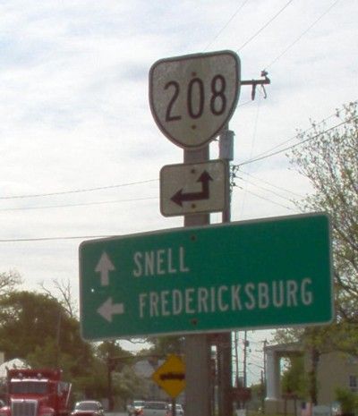
Comment: Serves Lake Anna. VA 208 will be rebuilt to bypass Spotsylvania C.H., Snell, and Post Oak. This will straighten out the curvier parts of VA 208.
|
| Previous VA 208's: |
|
VA 208 #1: Appeared in 1929 as a newly (?) numbered route. Ran from US 11 Salem to US 11 Hollins. This was renumbered as VA 117 in July 1933.
VA 208 #2: Appeared in July 1933 as a renumbering of VA 615. Ran from US 1 south of Thornburg to VA 2 Villboro. This was downgraded to SR's 606 and 625 between 1945-47.
|
 |
From: VA 28 Dulles (Loudon County)
To: Virginia Center for Innovation in Herndon (Fairfax County)
Total Length: 0.88 mile
|
|
|
|
|
ROUTE LOG
VA 28: 0 - 0
FX-LN LINE: 0.75 - 0.75
END VA 209: 0.13 - 0.88
|
|
Creation: Appeared in 1992 as new construction. Ran as it does today. This is the 4th VA 209.
Adjustment: None
Posting: Only a white rectangle at VA 28.
Comment: The building VA 209 serves is an oddly shaped monster that is visible for miles around the Dulles Corridor. VA 209 is the lowest number assigned specifically to a Virginia State facility (although an argument might be made VA 133 qualifies)
|
| Previous VA 209's: |
|
VA 209 #1: Appeared in 1929 as a newly numbered route. Ran from US 11 Cloverdale west past Catawba to the Roanoke-Montgomery County Line. In 1930-31, VA 209 was extended west to VA 23 (curr US 460 Bus) Blacksburg with a small gap 4 miles east of Blacksburg. This was all renumbered as VA 114 in July 1933. Today it is SR 779 and SR 785.
VA 209 #2: Appeared in July 1933 as a renumbering of VA 616. Ran from VA 51 (curr VA 208-SR 738 jct) Snell west to Paytes, then south a couple miles before ending. VA 209 west was truncated to Paytes between 1945-47, leaving behind SR 613. VA 209 was downgraded to SR 606 (now SR 608) between 1948-50.
VA 209 #3: Appeared between 1959-61 as a newly numbered stub off VA 205 south of Colonial Beach to serve James Monroe's Birthplace. This was downgraded to SR 625 in 1971-72.
|
 |
From: US 29 Bus Madison Heights (Amherst County)
To: FUTURE US 29 (Amherst County)
Total Length: ~3 miles
|
|
|
|
|
ROUTE LOG
US 29 Bus: 0 - 0
US 29: 0.54 - 0.54
VA 210Y?: 0.2 - 0.74
FUTURE US 29: 2.25 - 3
|
|
Creation: Appeared in 1962 as a renumbering of part of current VA 130. This is the 3rd VA 210.
Adjustment: VA 210 was extended east to the US 29 Madison Heights Bypass in early 2005 over new alignment. The old stub leading to VA 334 is currently labeled as "VA 210" in the field as of 5/8/05. I am curious if this is now VA 210Y. Perhaps the July 2005 Route Log will tell me when it comes out.
Posting: Fully posted
Comment: The interchange with current US 29 Bypass has been modernized.
|
| Previous VA 210's: |
|
VA 210 #1: Appeared in 1929 as a new route. Ran from US 11 Radford to VA 205 (curr US 221) Willis. In 1930-31, VA 210 was extended south to VA 12 (curr US 58) Vesta with a small gap near Vesta. This was renumbered as VA 102 in July 1933. Today it is SR 787 and SR 799.
VA 210 #2: Appeared in July 1933 as a renumbering of VA 617. Ran from VA 51 (curr VA 208) Spotsylvania C.H. to VA 3 near Wilderness. This was downgraded to SR 613 in 1953.
|
 |
From: VA 42 Timberville (Rockingham County)
To: I-81 & US 211 New Market (Shenandoah County)
Total Length: 6 miles
|
|
|
|
|
ROUTE LOG
VA 42: 0 - 0
SH-RO LINE: 4 - 4
I-81 (exit 264), US 211: 2 - 6
|
|
Creation: Appeared in 1978 as a renumbering of VA 260. Ran as it does today. This is the 3rd VA 211.
Adjustment: None
Posting: Fully posted. Cutouts at VA 42 have been removed, I believe. Erroneous US 211 signs abound, including VA 42 NB, I-81 (has US 211 and VA 211 going wrong directions), and at intersections in between.
Comment: A state hwy extension of US 211.
|
| Previous VA 211's: |
|
VA 211 #1: Appeared in 1923. Ran from VA 21 (curr US 15-29) New Baltimore to VA 21 (curr US 29) Centreville, via Manassas. In 1922 this had been part of VA 21, plus east of Manassas it was also part of VA 25. Between 1924-27, VA 211 was renumbered as the far northern segment of the original VA 28. Today it is all of VA 215, and some of VA 28.
VA 211 #2: Appeared in 1929 as a newly numbered route. Ran from VA 23 (curr VA 8) Riner to VA 210 (curr SR 787) near Radford. This was renumbered as VA 110 in July 1933. Today it is SR 658.
|
 |
From: VA 3 Bus Fredericksburg (Stafford County)
To: VA 218 White Oak (Stafford County)
Total Length: 1 mile
|
|
|
|
|
ROUTE LOG
VA 3 Bus: 0 - 0
VA 218: 1 - 1
|
|
Creation: Appeared in June 2004 CTB Minutes as a renumbering of a part of VA 218. Ran as it does today. This is the 6th (!) VA 212.
Adjustment: None
Posting: Fully posted this way starting Sept. 22, 2004
Comment: This alteration of the VA 212-218 set-up makes sense in terms of trying to get Dahlgren traffic to I-95 on one number...
|
| Previous VA 212's: |
|
VA 212 #1: Appeared in 1923. Ran from VA 21 (US 211 Bus) Luray to VA 17 (curr US 33 Bus) Elkton. Stanley to Luray was a piece of the original VA 16 prior to this. VA 212 was renumbered as VA 251 in 1928. Today it is US 340 and US 340 Bus
VA 212 #2: Appeared in 1929 as a newly numbered route. Ran from VA 205 (curr US 221) Hillsville to US 11 (curr VA 99) Pulaski via Draper, with a a break between Betty and the Pulaski County Line. In 1930-31 VA 212 became a continuous route. In 1932, US 11 and VA 212 switched alignments at Draper, with VA 212 following what is now VA 99 to Pulaski, and US 11 routed the way it is now. VA 212 was renumbered as VA 99 and VA 100 in July 1933. The part from Draper to Sylvatus is now SR's 658-653-693.
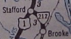
VA 212 #3: Appeared in July 1933 as a renumbering of VA 618. Ran from US 1 Stafford C.H. to Brooke. Early maps suggest a second stub from VA 218 white Oak along current SR 607 but this is uncertain. VA 212 was downgraded to SR 687 between 1948-50. Today it is SR 630 and SR 629.
VA 212 #4: Appeared as new construction in 1977. Ran from US 58-221 (curr VA 94) near Galax southwest to SR 638. In 1978, this was extended further west to meet back up with US 58-221 (curr VA 274). In 1980 this VA 212 was renumbered as US 58-221.
VA 212 #5: Appeared in 1986 as an upgrade to SR 664. Ran from US 1, US 17 Bus Falmouth east to VA 218 White Oak. In December 2002, VA 212 east was shortened 0.3 miles as VA 218 was reconfigured over part of VA 212. This VA 212 met its end in June 2004 when VA 218 was rerouted over its entirety, although is was posted as VA 212 until 9/22/04.
| 
VA 212 in 1941. |
 |
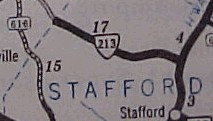
From: VA 28 City of Manassas Park
To: Manassas City Limit
Total Length: 1.9 miles
|
|
|
|
|
ROUTE LOG
VA 28: 0 - 0
PW-MPK LINE: 1.9 - 1.9
|
|
Creation: Appeared in 1975, the same year Manassas Park became an independent city. Ran as it does today. This is the 4th VA 213.
Adjustment: None
Posting: No postings at all (confirmed Dec. 2002). There was a sign on VA 28 SB until recent construction removed it. They did not replace the sign
Comment: This is a completely residential street, with not much purpose as a state hwy.
|
| Previous VA 213's: |
|
VA 213 #1: Appears on the 1928 VDOT map, running from VA 32 (curr US 15-29 Bus) Culpeper north to Rixeyville. It must have been envisioned to connect to VA 21 near Amissville, but 1929 came along and 213 was renumbered as part of VA 28. Today it is part of VA 229.
VA 213 #2: Appeared in 1929 as a renumbering of original VA 109. Ran from US 11 Dublin to VA 23 (curr US 460 Bus) Pearisburg. In 1930-31, VA 213 was extended south to US 11 (curr VA 99 McAdam). In 1932, VA 213 was extended south again to where I-81, US 11, and VA 100 meet. This was a renumbering of part of US 11. VA 213 was renumbered as part of VA 100 in July 1933.
VA 213 #3: Appeared in July 1933 as a renumbering of VA 619. Ran from US 1 Aquia west to the Fauquier County line. This was downgraded to SR 676 between 1942-44. Today it is SR 610.
| 
VA 213 in 1941. |
 |
From: VA 3 Lerty (Westmoreland County)
To: Stratford Hall (Westmoreland County)
Total Length: 2.48 miles
|
|
|
|
|
ROUTE LOG
VA 3: 0 - 0
END VA 214: 2.48 - 2.48
|
|
Creation: Appeared in July 1933 as a renumbering of VA 620. Ran as it does today. This is the 2nd VA 214.
Adjustments: None
Posting: Fully posted
Comments: serves the birthplace of Robert E. Lee; VA 214 proceeds past the entrance to Stratford Hall and ends on the backside of the plantation (road continues as SR 609).
|
| Previous VA 214's: |
|
VA 214 #1: Appeared in 1929 as a newly numbered route. Ran from VA 22 (curr VA 311) west to Craig Healing Springs. This was renumbered as VA 113 in July 1933. Today it is SR 658.
|
 |
From: US 15 & US 29 New Baltimore (Fauquier County)
To: VA 28 Bristow (Prince William County)
Total Length: 7 miles
|
|
|
|
|
ROUTE LOG
US 15, US 29: 0 - 0
PW-FQ LINE: 1 - 1
VA 28: 7 - 7
|
|
Creation: Appeared as a renumbering of VA 295 in 1963 or 1964. Ran as it does today. This is the 3rd VA 215.
Adjustments: None
Posting: Fully posted
Comment: The 1962 VDOT map shows this as VA 11, which I think is erroneous...
|
| Previous VA 215's: |
|
VA 215 #1: Appeared in 1929 as a newly numbered route. Was a short stub west off VA 17 (curr US 220) Eagle Rock. In 1930-31, VA 215 expanded to 2 pieces: 1. VA 10-VA 205 (curr US 460 Bus-VA 122 Bus) Bedford northwest to the Botetourt County Line 2. from a point 2 miles west of US 11 Buchanan to 4 miles west of VA 17 (curr US 220) Eagle Rock. Both pieces were renumbered as VA 43 #2 in July 1933. The part west of Eagle Rock is now SR 615.
VA 215 #2: Appeared in July 1933 as a renumbering of VA 621. Ran from US 17 Tappahannock west for 8 miles towards Sparta. VA 215 was downgraded to SR 627 between 1945-47.
|
 |
From: US 17 Hayes (Gloucester County)
To: SR 649/653 Bena (Gloucester County)
Total Length: 3.61 miles
|
|
|
|
|
ROUTE LOG
US 17: 0 - 0
SR 653-SR 649: 3.61 - 3.61
|
|
Creation: Appeared as a renumbering of VA 622 in July 1933. Ran as it does now. This is the 2nd VA 216.
Adjustments: Okay, VA 216 was slightly longer until US 17 was rebuilt east of its original alignment. This shaved 0.2 miles (10% of its length) off VA 216.
Posting: Fully posted
Comment: I drove this in 1993 and don't recall a thing about it.
|
| Previous VA 216's: |
|
VA 216 #1: Appeared in 1929 as a replacement for the original VA 231. Ran from VA 23 (curr US 460) Rich Creek northeast to then-WV 24. This was renumbered as VA 124 in July 1933. Today it is US 219.
|
|
Serves 2.2 miles worth of roads inside Southwestern State Hospital in Marion (Smyth County). It is posted at VA 16 near the I-81 interchange. The hospital has been there for a very long time, but I cannot say for certain how long VA 217 has been attached to it. When I drove by in 1993, it was posted with a 70's looking cutout. At any rate, it can't be older than 1941, and it is the 3rd VA 217. VA 217 also touches US 11-VA 16 within Marion, but I did not see VA 217 signs there.
|
Previous VA 217's: |
|
VA 217 #1: Appeared in 1929 as a renumbering of VA 221. Ran from VA 209 (curr SR 779) to the Catawba Hospital. This was renumbered as VA 123 in July 1933. Today it is VA 320. The 1929 Official Map erroneously labels this as VA 221.
VA 217 #2: Appeared in July 1933 as a renumbering of VA 623. Ran from US 17 Ark to just short of Almonds Wharf. This was downgraded to SR 606 between 1942-44.
|
 |
From: US 1, US 17 Bus Falmouth (Stafford County)
To: VA 205 Ninde (King George County)
Total Length: 28 miles
|
|
|
|
|
ROUTE LOG
US 1, US 17 Bus: 0 - 0
VA 212: 1 - 1
KG-ST LINE: 6 - 7
VA 206 WB: 13 - 20
VA 206 EB: 1.5 - 21.5
US 301: 0.5 - 22
VA 205: 6 - 28
|
|
Creation: Appeared as a renumbering of VA 624 in July 1933. Ran from VA 3 to VA 206 near Owens. This is the 2nd VA 218.
Adjustments: VA 218 was extended east to VA 205 between 1968-70.
In June 2004, VA 218 was rerouted (CTB minutes) to end in Falmouth instead of VA 3 Bus at Fredericksburg, replacing all of VA 212 #5. The piece between 212 and 3 Bus became VA 212 #6.
Posting: Fully posted; switch with VA 212 on the western end wasn't posted as such until 9/22/04.
Comment: VA 218 between SR 600 and VA 206 is quite a fun drive with major sharp curves and blind steep drops. Passes through the Caledon Natural Area, one of the last remaining old growth forests in the Eastern US.
|
| Previous VA 218's: |
|
VA 218 #1: Appeared in 1930-31 as a newly numbered route. Ran from VA 23 (curr US 460 Bus) to US 11 in the Christiansburg area. This was renumbered as VA 111 in July 1933.
|
| VA
219 not currently assigned |
|
|
|
|
| Previous VA 219's: |
|
VA 219 #1: Appeared in 1930-31 as a newly numbered route. Was a short spur running north of VA 20 (curr VA 40) Ferrum. In 1932, a second piece ran from US 311 (curr US 220) Boone Mill west towards Calloway. This second piece replaced VA 223. Both pieces were renumbered as VA 120 in July 1933. Today it is parts of SR 739 and SR 602.
VA 219 #2: Appeared in July 1933 as a renumbering of VA 625. Was a short spur off VA 30 west of West Point. This was renumbered as VA 124 in 1938. Today it is SR 635.
|
| VA
220 not currently assigned |
|
|
|
|
| Previous VA 220's: |
|
VA 220 #1: Appeared in 1930-31 as a newly numbered route. Ran from VA 200 (curr VA 103-SR 778 jct) Southwest to then-NC 80. This was renumbered as part of VA 103 in July 1933.
VA 220 #2: Appeared in July 1933 as a renumbering of VA 626. It ran from VA 30 King William south toward Lanesville. This was renumbered as VA 293 in 1935. Today it is SR 633.
VA 220Y: Mentioned in the August 1951 CTB Minutes at the Bassetts Fork intersection with VA 57 (which also had a 57Y at this location...). Presumably this was eliminated the same time as 57Y in 1978.
|
| VA
221 not currently assigned |
|
|
|
|
| Previous VA 221's: |
|
VA 221 #1: Appeared in 1923 as a newly numbered route, running from VA 22 (curr VA 311) to the Catawba Hospital. This was renumbered as VA 217 in 1929. Today it is VA 320.
VA 221 #2: Appeared in 1932 as a newly numbered route. Ran from US 11 Roanoke to VA 208 (curr VA 117). In July 1933 this became today's VA 118.
|
 |
From: VA 200 Irvington (Lancaster County)
To: Weems (Lancaster County)
Total Length: 4 miles
|
|
|
|
|
ROUTE LOG
VA 200: 0 - 0
END VA 222: 4 - 4
|
|
Creation: Appeared in July 1933 as a renumbering of VA 627. Ran as it does today. This is the 2nd VA 222.
Adjustments: None
Posting: Fully posted
Comment: This is the only Northern Neck state route I have not driven any of.
|
| Previous VA 222's: |
|
VA 222 #1: Appeared in 1930-31 as a newly numbered route. Ran from VA 205 (curr US 221) near Floyd to VA 20 (curr VA 40) Endicott, with a break in the middle. This was renumbered as VA 109 in July 1933. Today it is SR 681 and SR 793.
|
 |
From: VA 198 Hudgins (Mathews County)
To: SR 633 Gwynn Island (Mathews County)
Total Length: 2 miles
|
|
|
|
|
ROUTE LOG
VA 198: 0 - 0
SR 633: 2 - 2
|
|
Creation: Appeared in July 1933 as a renumbering of VA 629. Ran from VA 198 only to Cricket Hill (other side of water from Gwynn Island). This is the 2nd VA 223.
Adjustments: VA 223 was extended onto the island at some point (VDOT maps are vague about this). Maps through 1944 are clear it is not on the island (although a bridge existed in the early 40's), and it was on the island when I drove there in 1992.
Posting: Fully posted.
Comment: I drove it in 1992 and have no recollection of anything exciting.
|
| Previous VA 223's: |
|
VA 223 #1: Appeared in 1930-31 as a newly numbered route. Ran from US 311 (curr US 220) Boone Mill southwest 5 miles. This was renumbered as a second piece of VA 219 in 1932. Today it is SR 739.
|
 |
From: US 58-421 Weber City (Scott County)
To: Tennessee State Line (Scott County) near Bloomingdale, TN (continues as TN 93 to US 11E-321 Geenville, TN)
Total Length: 3.35 miles
|
|
|
|
|
ROUTE LOG
US 58, US 421: 0 - 0
TN STATE LINE: 3.35 - 3.35
|
|
Creation: Appeared in 1992 as an upgrade to SR 701. Ran as it does today. This is the 4th VA 224.
Adjustments: None
Posting: Assumed to be fully posted
Comment: Never seen this one. Another VA-TN route conflict, although VDOT could not make this VA 93 without fouling up the current VA-NC 93 setup.
|
| Previous VA 224's: |
|
VA 224 #1: Appeared in 1932 as a newly numbered route. Ran from VA 23 (curr US 460) near Newport to Moutnain Lake. This was renumbered as VA 112 in July 1933. Today it is SR 700.
VA 224 #2: Appeared in July 1933 as a renumbering of VA 630. Ran from VA 14 Foster down to Mobjack. This was downgraded to SR 660 in 1952.
VA 224 #3: Appeared in 1980 as a newly constructed freeway. Ran from US 29 to US 460 (curr US 460-US 501 Byp NB jct) in Lynchburg. In 1984 VA 224 was extended south to SR 678. VA 224 was rechristened as part of US 460 in 1989.
|
 |
From: I-264 City of Virginia Beach
To: US 60 Little Creek (City of Virginia Beach)
Total Length: 5 miles
|
|
|
|
|
ROUTE LOG
I-264 (exit 17): 0 - 0
US 58: 0.5 - 0.5
VA 190: 1 - 1.5
US 13: 3 - 4.5
US 60: 0.5 - 5
|
|
Creation: Appeared as a new alignment in 1967. Ran from US 58 to US 60. This is the 3rd VA 225.
Adjustments: VA 225 was extended south to VA 44 (curr I-264) between 1968-70.
Posting: Fully posted as late as the early 90's, except was not identified from VA 44. I do not know if I-264 designation changed this. White bordered sign existed at VA 190, but may be gone now. I think there is a circle 225 on US 60 EB.
A. Froehlig reports VA 225 is still posted at US 58 and US 60, with a US 225 shield on US 60 EB and also a circle. Only 3 reassurance shields remain anywhere on VA 225.
Comment: Independence Blvd. This route is all suburban today.
|
| Previous VA 225's: |
|
VA 225 #1: Appeared in December 1932 as a new state route, running from VA 10 (curr US 221-460) Roanoke up towards Hollins along Tinkers Creek (CTB minutes). In July 1933, this became VA 115. Today this may also include some of SR 601. This is the highest VA 2xx route in the 1929-33 system I could find.
VA 225 #2: Appeared as a new route in July 1933. Ran from VA 198 Cobbs Creek to VA 33 Hartfield. This included a ferry over the Piankitank River until the mid 40's. This VA 225 was renumbered as part of VA 3 in 1957.
|
Last Update: 25 June 2005
Previous: VA 176 - 200 |
Next: VA 226 - 250
Top | Virginia Hwy Index
Home
| |

