
< US 48 | Home | US 52 > | |||||||||||||||||||||||||||||||||||
|
|
|
|
| ROUTE LOG |
WV STATE LINE: 0 - 0 VA 259: 3 - 3 VA 37: 10 - 13 WIN-FD LINE: 0 - 13 US 11 NB, US 522 NB, VA 7: 2 - 15 US 11 SB, US 17 BEGIN: 0.75 - 15.75 FD-WIN LINE: 1 - 16.75 I-81 (exit 313): 0 - 16.75 US 522 SB: 0.25 - 17 CK-FD LINE: 4 - 21 US 340: 3 - 24 VA 255: 2 - 26 FQ-CK LINE: 6 - 32 US 17 SB: 1 - 33 LN-FQ LINE: 11 - 44 US 15: 7 - 51 FX-LN LINE: 8 - 59 VA 28: 2 - 61 I-66 (exit 57): 5.75 - 66.75 FAX-FX LINE: 1 - 67.75 US 29 SB, VA 236: 0.25 - 68 VA 123: 1 - 69 US 29 NB, VA 237 EB: 1.75 - 70.75 VA 237 WB: 0.25 - 71 FX-FAX LINE: 0 - 71 I-495 (exit 50): 2.5 - 73.5 VA 7: 3 - 76.5 AR-FX LINE: 0.5 - 77 VA 120: 1.5 - 78.5 VA 27: 0.5 - 79 VA 237: 0.5 - 79.5 I-66 WB (exit 75), GW PKWY: 1 - 80.5 DC LINE: 0.5 - 81
|
Creation: Appeared in Virginia as an original US Route in 1927. Ran more or less the way it does now. US 50 was added as a multiplex to the original VA 36.
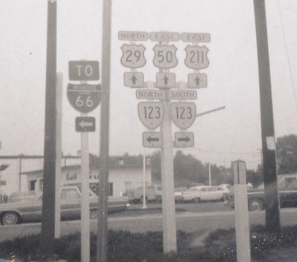
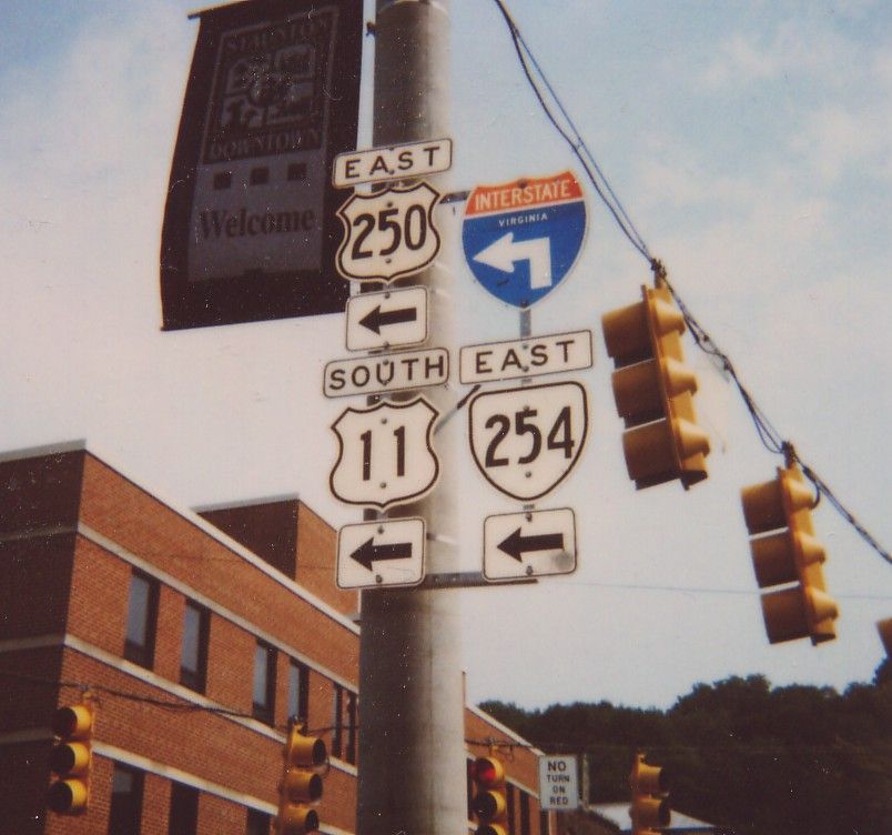
| Adjustments: In 1929, US 50 was rerouted east of Fairfax over new routing to US 1 Alexandria. US 50 multiplexed with US 1 from there to D.C. The original US 50 from Fairfax to D.C. became an extended US 211. Today this is mostly part of US 29. Between 1935-37, US 50 was moved again in Fairfax County. From Fairfax US 50 went east along Arlington Blvd, replacing the original VA 236. However, US 50 actually dead-ended just east of VA 9 (curr VA 120) Glebe Rd, short of Ft. Meyer. The Arlington inset of the 1937 Official Map states that "US 50 is not a through route and to use US 211". US 50 picked up again at the east edge of Arlington National Cemetery and used the Memorial Bridge to D.C. The Fairfax to Alexandria routing became VA 236 #2. US 50 became continuous again through Arlington in 1938, with new construction routing US 50 around the north end of Ft. Meyer/Arlington Nat'l Cemetery. US 50 was taken off of Arlington Ridge Blvd. near the Memorial Bridge in this adjustment. The 1939 and 1941 Esso maps show US 50 Byp running along the Potomac from the Memorial Bridge to US 1 before crossing into D.C. No VDOT map I have shows this, though. Between 1938-41, US 50 received a new alignment from the Shenandoah River to nearly Winchester. This was new construction. The old route through Millwood and Boyce became SR 723. US 50 was eventually moved from the Memorial Bridge to the current bridge with I-66. The bridge was completed 1960-61, but VDOT maps do not really show when US 50 was put on it. I-66 was labeled on it starting in 1975. US 50 was also rerouted in Winchester sometime after 1941. Originally, US 50 WB crossed US 11 and zigzagged north, then west, using Braddock St. Winchester insets disappeared for many years, so the exact point this was changed to the current zigzag with US 11-522 is unknown. However, the old alignment is still posted WB once you cross US 11. Posting: Fully posted; cutouts in Winchester (Thanks Gribblenation). Check out this Fairfax cutout assembly from 1969! Comment: Arguably the most important non-interstate road in the United States today. In Virginia, it starts as the six-lane Arlington Blvd. before running through the endless suburbs of Fairfax County (including a multiplex with US 29 in Fairfax City). After that, it narrows to a two-lane road through the rolling hills of Middleburg and Upperville before merging with US 17 and becoming divided four-lane from Paris to Winchester. After that, it follows the Northwestern Turnpike up into the mountains of West Virginia. As an interesting side route, try SR 723 (old US 50) in Clarke Co. Or, even better, drive SR 734 from Aldie to VA 7 at Bluemont (not ever part of US 50, but has a couple 19th century bridges). Just west of US 15 in Aldie US 50 uses a 19th century bridge to get over a creek. US 50 is the longest US route in Virginia with no Business Routes. |
|||
|
|
|
|
| ROUTE LOG |
WV STATE LINE: 0 - 0 US 220: 14 - 14 AU-HI LINE: 19 - 33 VA 42 NB: 17 - 50 VA 42 SB: 0.5 - 50.5 STA-AU LINE: 6.75 - 57.25 VA 275: 0.25 - 57.5 US 11 Bus NB: 2.5 - 60 VA 254: 0.25 - 60.25 VA 252: 0.25 - 60.5 US 11 NB, US 11 Bus END, VA 254: 0.25 - 60.75 US 11 SB: 0.25 - 61 VA 261: 1 - 62 AU-STA LINE: 2 - 64 I-81 (exit 222): 0 - 64 VA 358: 2 - 66 VA 285: 2 - 68 WNB-AU LINE: 4 - 72 US 340: 1.75 - 73.75 VA 254: 0.25 - 74 US 340 SB: 1.25 - 75.25 US 340 NB: 0.25 - 75.5 AU-WNB LINE: 1.5 - 77 I-64 (exit 99): 1.75 - 78.75 BLUE RIDGE PKWY, SKYLINE DR: 0.25 - 79 NL-AU LINE: 0 - 79 VA 6: 1.25 - 80.25 AL-NL LINE: 0.25 - 80.5 VA 151: 1.75 - 82.25 I-64 (exit 107): 4 - 86.25 VA 240: 1 - 87.25 VA 240: 3 - 90.25 US 29 SB, US 250 Bus: 6 - 96.25 CHA-AL LINE: 1.5 - 97.75 US 29 NB: 0.5 - 98.25 US 250 Bus, VA 20 SB: 3 - 101.25 AL-CHA LINE: 0 - 101.25 VA 20 NB: 0.25 - 101.5 I-64 (exit 124): 2 - 103.5 VA 22: 1.5 - 105 FV-AL LINE: 4 - 109 LO-FV LINE: 3 - 112 US 15: 4 - 116 VA 208: 7 - 123 FV-LO LINE: 2 - 125 GO-FV LINE: 1 - 126 LO-GO LINE: 12 - 138 US 522: 1 - 139 GO-LO LINE: 2 - 141 VA 288: 14 - 155 HR-GO LINE: 0.5 - 155.5 VA 271: 3 - 158.5 I-64 (exit 178): 0.5 - 159 VA 157: 2 - 161 I-64 (exit 183): 3 - 164 US 33 WB: 2 - 166 VA 197: 0.5 - 166.5 RIC-HR LINE: 0 - 166.5 VA 161: 1 - 167.5 VA 399: 0.5 - 168 VA 399: 0.25 - 168.25 US 33 END, VA 33: 0.5 - 168.75 US 1, US 301: 0.25 - 169 I-95 (exit 74): 1.5 - 170.5 US 360: 0.25 - 170.75 US 60: 0.25 - 171
|
Creation: US 250 appeared in Virginia in 1935. It ran very much as it does now except in the Crozet area. US 250 was a straight renumbering of all VA 5 west of Richmond.
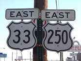
| Adjustments: Between 1942-44, US 250 was rerouted to bypass Crozet, which it used to go through. The bypass had been the original VA 240. The route through town became VA 240 #2 and an extended VA 230. Today this is all VA 240. Posting: Fully posted; cutouts in Staunton; A US 33-250 cutout assembly (thanks Gribblenation for pic!) was spotted by me in March 2003. Error VA 250 sign just west of VA 157. US 250 is very poorly posted east of US 1-301 in Richmond, and not posted at all east of I-95 or at US 60. Comments: A very minor US highway in most of VA due to I-64. US 250 is a pleasant country ride, though, once you escape the grasp of expanding Richmond. It's ascent of Afton Mtn. can be driven at 55 mph on both sides of the mountain. I've been told US 250 west of Churchville to WV and beyond is one of the twistier stretches of road around. |
|||
| US 250 ALT Decommissioned | |||
| Previous US 250 ALT's: |
US 250 ALT #1: Appeared between 1954-55 as new routing. Ran from US 250 at the Rivanna River bridge northwest to US 29 above Charlottesville. Between 1960-61 US 250A was extended west to meet up with US 250 to form a Charlottesville Bypass. US 250 ALT was changed to US 250 Bypass between 1968-70.
US 250 ALT #2: Mentioned in CTB Minutes 1955 and 1960 in Waynesboro. Presumably this is current US 250 where is bypasses the inner downtown area (which is still served by US 340). |
||
Previous: US 48 |
Next: US 52
Top | Virginia Hwy Index
Home
