
Weather radar is a certain type of radar known as Doppler radar, named because of the Doppler effect which recognizes that the frequency shift of waves bounced off of an object is related to the object's velocity towards or away from the observer (the common example of this effect is the change in pitch of a train whistle as it moves past an observer).
Doppler radar works by detecting the presence and location of an object by bouncing a radio wave off of it and detecting the time it takes for the signal to return. Using the time value, and a knowledge of the speed of the wave, the distance traveled can be determined. These radar waves are bounced off of moving objects. In the case of weather, these objects are raindrops, snowflakes or other forms of precipitation. Using the Doppler effect, the change in frequency of the returning wave, as compared to the frequency of the wave that was sent out, yeilds the direction and the speed that the object is moving (radially) away from or towards the detector source. This data is then electronically converted into pictures showing the location and intensity of precipitation. These images help to demonstrate how doppler radar works:


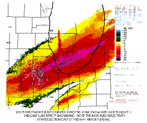
This element of radar technology is particuarly useful when dealing with severe storm prediction. Doppler radar can detect the speed and direction that a storm is moving, which is incredibly valuable in saving lives of people in thea area. In addition, images created using Doppler radar can indicate the conditions likely to produce strong thunderstorms even before they occur. This can also lead to the saving of life and property. Here are Doppler radar images of a hurricane (on the left) and lake enhanced snow (on the right):

NEXRAD Doppler Radar
NEXRAD stands for NEXt generation of doppler RADar. Also known as WSR-88D (the
88D means Doppler radar implemented in 1988) NEXRAD replaced the older mode of
doppler radar which had originally been put into use in the 1950's and was improved
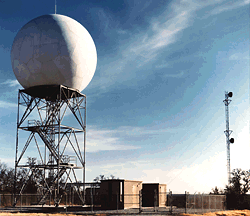
in the 1970's. NEXRAD consists of a nationwide network of highly advanced doppler
radar sites:

NEXRAD was implemented between 1992 and 1996 across the country. The NEXRAD technology, like regular Doppler radar, detects location and intensity of many forms of precipitation from light rain and snow up to thunderstorms. NEXRAD is an improvement over regular Doppler, because it detects up to 143 miles away from the NEXRAD site. NEXRAD also has the improvement of 1/2 mile resolution of detection of objects. NEXRAD is much more sensitive than regular Doppler radar. Unfortunately, this means that NEXRAD is much more likely to pick up "ground clutter" than regular doppler. This means that NEXRAD may interpret waves that have been bounced off of ground objects (mountains, hills, trees) as precipitation due to its high sensitivity.
NEXRAD excels in detecting severe weather events that threaten people and their
belongings. NEXRAD allows for early detection of damaging winds. It also
significantly increases tornado warning time. Tornados can actually be predicted
and detected before reaching the ground. With regular Doppler radar, tornado
warnings could not be issued until the tornado had actually formed and been
observed. Now, since the formation of tornados can be accurately predicted
before they form, people can be warned BEFORE tornado formation. In addition to
tornados, NEXRAD allows for improved forecasts of location and severity of
thunderstorms. This reduces the number of incorrect forecasts and false alarms,
which tend to cause people to disregard watches and warnings that are given.
NEXRAD is more sensitive than regular Doppler, and thus can predict different
kinds of precipitation and can more accurately predict precipitation
intensitites. This allows for more accurate observation of snowfall intensitites,
which was also not as possible with standard Doppler radar. Also, NEXRAD can
keep track of precipitation total amounts during the course of a storm. NEXRAD
has a large range of detection, as well. It has detected storms up to 200 miles
away from the radar site. NEXRAD can also be used to detect non-precipitation
events, such as wind speed and direction, wind gusts and frontal
boundaries without any associated precipitation. NEXRAD can detect these events
by bouncing waves off of dust particles moved by the winds or the frontal
boundaries. This is a good indication of how sensitive this type of radar really
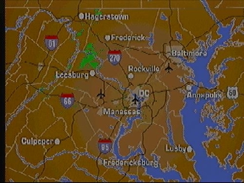
is. These images demonstrate the
difference in NEXRAD versus old doppler technology. The first image was
created with NEXRAD and the second image was created with regular doppler.
Both images were taken at the same time.

NEXRAD technology uses computers intensively. These computers are programmed to alert forecasters automatically when dangerous weather patterns develop. The resolution of images generated by NEXRAD have been compared to the intricacy of CAT scan images. A NEXRAD image comes from data averaged from 25 radar pulses in order to give a detailed and accurate image. NEXRAD has different settings in order to detect different weather phenomena. There is a setting for heavy precipitation and severe weather, and another setting for non-precipitation events like wind and frontal boundaries. Regular Doppler radar does not have the capacity to detect non-precipitation events and is less accurate at detecting severe weather events.
Thus, Doppler radar is an invaluable tool in forecasting weather. NEXRAD is even better at the forecasting of severe weather events, and may ultimately save lives.
Bibliography
AccuWeather, "Virtual Weather School: Doppler Radar".
"Doppler Radar is a Key Forecasting Tool" .USA Today: Weather. 23 January 1998.
"Doppler Radars in Washington".
National Weather Service, "Weather Surveillance Radar (WSR-88D)".
"Topic: RAdio Detection And Ranging".
The Weather Channel, "TWC Glossary: Doppler Radar".
The Weather Channel, "TWC Glossary: NEXRAD".
"Weather Service Adding to Radar Network". USA Today: Weather. 30 October 1997.
"Weather Service Retires Last of Old Radars" .USA Today: Weather. 18 December 1997.
"WSR-Weather Surveillance Radar".
Page by Emily Virkus
21 April 1998
Email: *virkus98 @ sbc . edu* (without spaces or stars)
