
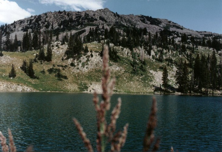
-Lower Red Pine Lake-
Trail Facts
The Red Pine Lake trail starts at the White Pine Trailhead, which is about a half mile down the canyon from Snowbird. This trailhead provides the only access to much of the Lone Peak Wilderness in the lower half of Little Cottonwood Canyon.From the parking lot, the trail crosses Little Cottonwood Creek and begins a somewhat gradual climb of 400 feet along an old jeep road which heads into White Pine Fork. This first climb is about 1 mile long and ends when you get to the White Pine Fork stream. At this point the trail forks off. One trail (the road) switches back to the left and heads toward White Pine Lake. Follow the trail which crosses a bridge to the right a short distance from the fork and continues around the ridge toward the Red Pine Fork. The trail levels out very nicely at this point and when you reach the Red Pine Fork side of the ridge you are rewarded with an amazing view of Little Cottonwood Canyon and the Salt Lake Valley. The glacier-carved canyon forms a perfect u-shape at the mouth of the canyon with the valley settled behind it.
After about .5 mile from the White Pine stream crossing the trail begins to get steep as it heads back into the trees toward Red Pine Lake. For about the next mile the trail climbs nearly 800 feet in elevation at the end of which the Red Pine Stream comes into view and you come to another junction. One trail turns right and crosses a bridge over the Red Pine Stream and heads toward Maybird Gulch and the Maybird Lakes. Follow the trail that continues the climb to the south toward Red Pine Lake, which lies another .7 mile from the junction. This final stretch remains somewhat steep, climbing another 600 feet in elevation to the lake.
Red Pine Lake is unique to the other lakes in the area. The water is a bluish-green color which looks awesome against the surrounding pines and white-alpine terrain. At the lake, the trail goes along the left (east) shoreline. It is, however, nice to traverse around the right (west) shoreline to a small bay located at the southwest corner of the lake which lies more secluded in the pines.
If you choose to go further, the Upper Red Pine Lakes lie about .4 mile southeast of the lower and 400 feet higher in elevation. To get to these two higher lakes, follow the trail around the east side of lower Red Pine Lake and begin a climb to the south/southeast from the inlet stream at the southeast corner of the lake. There is no defined trail beyond this point, but there are two general routes to the upper lakes. One route is to scramble up the rocky slope staying near the stream which takes you around a minor ridge and to the outlet of the upper lakes. The other route is to head directly south from the inlet of the lower lake, scrambling straight up a small boulder field to the top of the minor ridge which puts you slightly above the upper lakes. In late spring and early summer, consolidated snow covers these routes providing an easier ascent as it eliminates the boulder-hopping required when there is no snow. Above the Upper Red Pine Lakes, a popular hike climbs the ridge and heads toward the Pfeifferhorn.
The Pfeifferhorn
- Distance (one way): 4.5 miles
- Elevation gain: about 3700 feet
- Highest Point: 11,326 feet
Access to the Little Cottonwood/ Dry Fork Canyon ridge is achieved by traversing up the steep, boulder-filled slope to the southwest from the Upper Red Pine Lakes. Again, early summer snow provides a somewhat easier ascent to (and very easy and fun descent from) the ridge. The Pfeifferhorn lies about a mile to the west and has an elevation of 11,326 feet. The trail to the Pfeifferhorn follows the jagged ridge staying under and to the south of a minor summit between Red Pine Fork and Maybird Gulch then comes again near the top of the ridge which narrows to a knife-edged ridge. From here you must pick your way carefully over and around huge boulders until you reach the base of the mountain. Even though the final climb to the summit of the Pfeifferhorn looks extremely steep from a distance, it has a few well-beaten paths to follow and is not much different from the climb up to the ridge from the upper lakes. The view from the summit is amazing, from the entire back-side of Mount Timpanogos and Utah County to the jagged cliffs of Hogum Fork with the Salt Lake Valley behind.
 The view from Lower Red Pine Lake looking south toward the ridge. |
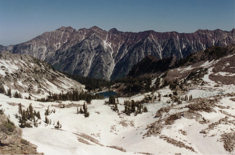 The view from the ridge looking north toward Lower Red Pine Lake and frozen Upper Red Pine Lakes. |
