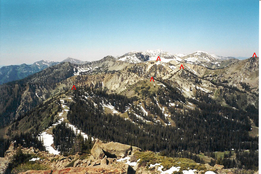
The view over Brighton from Clayton Peak. (marked in red are 5 of the 8 summits along the ridge)
Trail Facts
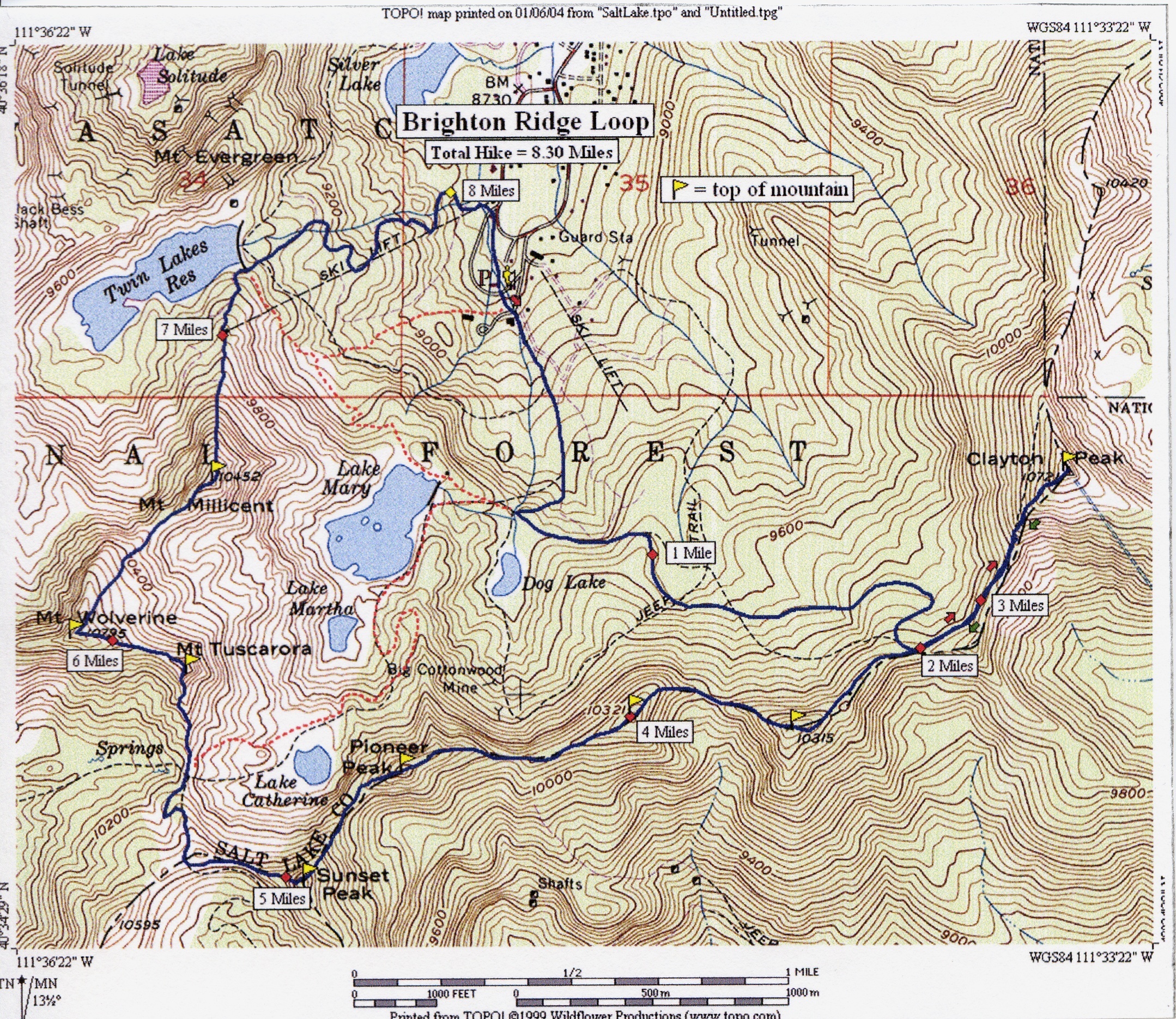
This is a peak-bagger's dream! The Brighton Ridge Loop trail climbs 8 mountain peaks as it traverses the ridge surrounding the Brighton Ski Resort. The trailhead is located at the south end of the resort parking lot and begins on the same trail as the Mary Lake trail. Follow this trail as it heads south toward Lake Mary. After about .75 mile and climbing 600 feet in elevation, the trail comes to a junction that splits in 3 directions. The middle trail and the trail to the right head toward Dog Lake and Lake Mary. Follow the trail to the left. After passing Dog Lake, the trail begins a traverse across much of the Brighton Ski Resort. This takes you in and out of the trees as you cross several ski runs and pass, first, under the Crest Ski lift and second, under the Snake Creek Lift. Shortly after passing the Snake Creek Lift, the trail merges with a service road which leads to the ridge at Snake Creek Pass. The distance from the junction to the ridge is about 1.5 miles and another 800 foot elevation gain.When you get to the ridge you have a choice. You can turn right and continue the loop, or you can turn left and take a side route to Clayton Peak. Clayton Peak would be the only part of the hike where you have to retrace your steps to get back on the loop. From Snake Creek Pass this route follows the service road along the ridge toward Clayton Peak. When you get to the steep ridge of Clayton Peak, a trail cuts off the road to the right and begins a series of short switchbacks up the ridge. Near the top of Clayton Peak some minor boulder-hopping is required, but nothing too technical at all. The distance from Snake Creek Pass to the top of Clayton Peak is about .4 mile and involves a 500 foot climb topping off at 10,721 feet. Not including the climb to Snake Creek Pass, this is the largest elevation gain along the ridge.
The route from this point on is very clear for the most part, yet seems to fade away at times. Some light scrambling may be required as you will have to traverse down on either side of the ridge to avoid certain obstacles. Just be sure to watch your step.
Following the service road past the point where you reached the ridge in a southwest direction (opposite that of Clayton Peak), the trail leads you to the top of the Snake Creek Ski lift. From here the trail begins an up and down series as it tops 4 mountain peaks in the next 2 miles. The view along this section of the ridge includes the Brighton area and much of the Heber Valley. The first two mountain peaks you come to here are unnamed and have elevations of 10,315' and 10,321' respectively. The trail along these peaks stays mainly on the Heber Valley side of the ridge and involves an elevation gain, loss, and gain of about 300 feet. Located at the saddle between Peak 10,315’ and Peak 10,321’ is the top of the Crest Ski Lift. An abrupt 300 foot climb from this saddle brings you to the top of Peak 10,321’. After Peak 10,321' the ridge drops about 200 feet then rises about 300 feet to the top of Pioneer Peak (10,420'), hanging still on the Heber Valley side. From Pioneer Peak you now have a great view of all the lakes around Brighton. The trail from the top of Pioneer Peak continues down the ridge on the Brighton side, dropping about 200 feet to the saddle below Sunset Peak. At this point the trail crosses over to the Heber Valley side of the ridge and begins a steep 400 foot climb to Sunset Peak (10,648'). After Sunset Peak, a well-beaten path follows the ridge west then north to Catherine Pass dropping 400 feet in elevation. If, at Catherine Pass, you decide you've had enough ridge climbing, you can take a trail down to Lake Catherine and follow the Lake Mary trail down to the parking lot.
If you wish to continue along the final 2.5 miles of the loop, follow the ridge to the north toward the top of Mt. Tuscarora (10,640'). This is a 400 foot climb from Catherine Pass. From Mt. Tuscarora, the ridge turns to the west, drops only about 40 feet, and climbs another 200 feet to the top of Mt. Wolverine (10,795'). The ridge then turns to the north and northeast and drops about 500 feet to a saddle below Mt. Millicent (10,452'). This final climb to Mt. Millicent is just less than 200 feet and involves more boulder-hopping toward the top. Mt. Millicent offers the best view of the hike you just did. From here, you can clearly see all 7 other peaks along the ridge. Carefully boulder-hop and make your way down the steep ridge to the north toward Twin Lakes Res. The elevation drop from the top of Mt. Millicent to Twin Lakes is about 900 feet. At the Twin Lakes dam, you can follow a service road to the right which leads to the parking lot, or you can follow a trail to the southeast (leading to Lake Mary) for about .25 mile until it comes to a junction. At this junction follow the trail that heads down the hill toward the parking lot to complete the loop.