
 I climbed Tangle Peak with my friend Mark Howell and his Dad on August 10th, 2002. It was in the middle of a 4 day camping trip at Waterfowl Lakes they invited me to. It was an overcast day, with a pile of fresh snow that morning. Some of it was still left at the summit at the time of year when nothing should be left over. We made good time with 3 hours on the ascent and about two thirds of that going down. There was no summit break, though. We parked at the beautiful Tangle Falls and headed off on the trail towards Wilcox Pass. After about 30 minutes much confusion came as we tried to find a path that dwindled across the creekbead. Soon realizing that the only way this path would be found would be if we imagined it, we set off up the opposite creekbed which came down from the prominent grotto on Tangle Peak. Soon, a faint trail appeared which seemed to grow the farther we got to treeline. Here we found masses of mosquitoes and this probably attributed to our fast ascent time in that we were in a race to get to treeline. Not bad weather for a forecast of showers. This is a picture just after exiting treeline of left to right: Kitchener, the Stutfield Glacier with the Columbia Icefields above it and Stutfield East, all 11,000 foot peaks.
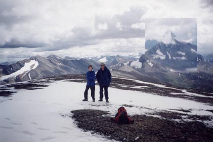
After a quick lunch, we continued up to the scree which was not bad at all. By now, most all of the snow had disappeared. The slope was gentle and it was just uphill hiking through the mounds of scree. At the top it became very chilly, probably below 0 degrees because of the faint snowfall on us. The weather was socking in and my hands were now frozen so we didn't spend long here, and our hopes of doing the ridgewalk down to Wilcox Pass were dashed. Wilcox Pass is to the right with Nigel Peak enlarged, just because I can do it! In the picture are Mark and Mr. Howell. Many of the front range peaks are visible, including Mount Cline somewhere. |
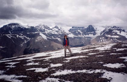
This is the picture the other way. On top there was this big ugly solar-powered piece of whatever it was. My point is it didn't really fit in with the surroundings, so we tried to dodge it with the pictures. It is out of sight on the right. From left to right are:Stutfield East, West, Alberta in the clouds, Woolley and Diadem, all 11,000 foot peaks. The descent was uneventful but cold until we reached treeline, when the sun started coming out. Great views of Kitchener were had. Once we arrived at the road we were amazed to see two fully-grown bighorn sheep each with a full ring of horns. They were situated across the highway from us which was actually a trench, so there were cliffs on each side of it. But even more impressive were about 30 or 40 cars parked on the road following these sheep with cameras in hand. I took a picture of the tourists! Mr. Howell commented that the tourist appeared to be in a cage, with us on one side and the Bighorn Sheep on the other. I'm sure the sheep found it the same way. After that we climbed up the falls trying to spoil the tourists' views, had a quick head-numbing dip and set off. |

Mark and I had not had enough, and we were ahead of schedule, so we went up Parker's Ridge to catch a glimpse of the Saskatchewan. We were half of the recommended time, so we quickly sped off back to the campsite for a much anticipated swim. This is the Mistaya River, and yes it was cold, and no I don't regret it! Mark's mom took this picture from the brige. Mark seeing how fun it seemed jumped in as well. The hardest part is getting in the water without having a heart attack. We swam downstream a ways and went to find a good natural pool. We ended up finding one about 4 feet deep which made for good fun, but the Lower Waterfowl Lake was even better. One of the funnest parts was watching the campers gather and look confused at what we were doing. Now that's living! I actually did have swim shorts on in this picture! |
