
Nigel Peak (3213m) |

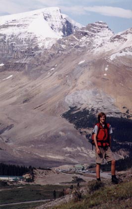
I did Nigel Peak with my Dad on August 17, 2002. On the drive there it was my first time driving to the mountains in the morning. What I was afraid of were deer, and sure enough 16 deer were on the road on my drive there.... and in 6 different groups! 3 of those groups of deer darted across the road. On the way back I only met about 5 deer but about 6 elk as well. Anyways, we were scared as we approached the rockies because of the massive amount of snow on the Front Range Peaks. Seeing this, we knew what we were in for further in, but miraculously the peaks were almost void of snow. This is the picture of Nigel from the shoulder halfway up. The route through the bowl was deceivingly steep, and step-kicking was exhausting for some reason. The rest of the route follows directly up the left skyline, with the arrow pointing to the sting in the ridge we later affectionately called "the Hillary Step". You'll see why. It is a fairly short trip with 1200 m. of elevation. Not much considering it's over 10,500 feet. |

As we drove near the Columbia Icefields I was really excited as it looked like we might have good weather. We followed the directions and parked at the Wilcox Campground, shown here. The trail is for Wilcox Pass. In the book we read after 5 minutes of this trail turn right on a faint trail. This faint trail simply did not exist, but on the way back we came upon it. It was about 20 minutes up the trail. 5 minutes of FIERCE tree-slappin' weed-whackin' bush ensued until we reached this meadow where it was only this annoying knee-high shrub for the next 15 minutes or so. |
This is the view from after the bush, almost reaching the scree. You can see the Icefield Center at the bottom, with impressive Mount Kitchener on the horizon. We picked a route up what looked like the most feasible slope up to the shoulder. It was the most feasible, but it was something that I would never again in my life repeat. It was the WORST and most tedious scree I have yet to encounter. One time I moved 2 feet in 10 steps, and that wasn't just one case. It happened many a time. Just when you thought you couldn't take any more of this scree these ledges appear above you, but I found these were even worse as they were covered in pebbles. Two thirds of the way up we found a rock rib jutting out of the scree which we happily scrambled up to the shoulder.
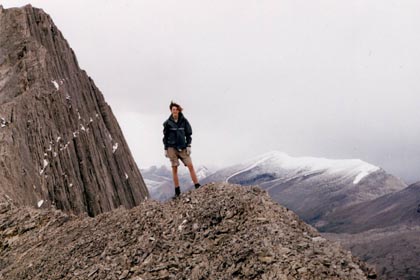
After the slowest scree and slabs I have yet to encounter in the rockies, we reached the shoulder. We followed this ridge(the other way) until the bowl. It was nice to reach the ridge as the views were much nicer, and the Bugaboo-like bump in the ridge behind me was impressive. Behind me is Tangle Peak which I climbed last week with Mark and his Dad. We continued along the ridge on rock and mud..uck! until the bowl where I kicked some steps up some deceivingly steep and hard snow. For some reason it was very exhausting. The temperature kept getting lower and lower and the weather kept gettin worse and worse until we hit the ridge where all rock was covered in 3 mm of verglas, and we encountered a FOOT of fresh powder!

The ridge proved to be the very difficult part. We felt lucky to have this snow only come up to our ankles at sometimes, but it was fresh powder and I made sure to scrape away all the snow from where I was about to put my foot. Just 5 feet to the left of us was half a foot of powder with pure ice underneath. Anyone who doesn't believe that is dangerous should have seen my Dad almost lose it for good on the descent. Soon the visibility was 10 feet, and the temperature plummeted, and the wind picked up. The sprindrift stung badly at times. All of a sudden a break in the clouds permitted us to see about 30 feet in front of us and there was this 30 foot wall in the ridge. The conditions made it look like it should be on Mount Everest, so I called it the Hillary Step. So did Dad. All the rock was covered in a foot of fresh powder, underneath which was verglas. No foothold was taken for granted. My Dad almost didn't make it past this, but I told him that from above I though I could see the top. I rather recklessly went up this, and it was quite stupid how carelessly I went up, hoping that under the snow was a solid rock. This is my Dad on the summit with Athabasca on the right.
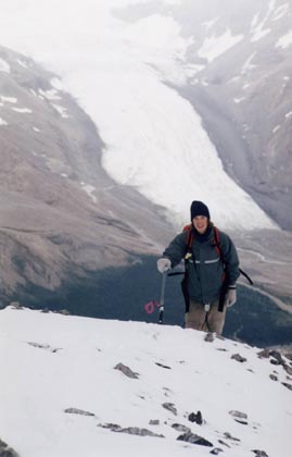
After the big rock step that we both luckily surmounted was a short walk through shallow hard-packed snow to the top. The camera wouldn't take a picture because the batteries were frozen, so we had to stick them in the armpits and gloves for a chilly 5 minutes before we could barely squeeze pictures out of them. My Dad took this from the top of me coming up the final ridge.. but this isn't even the ascent ridge. The ascent ridge is in the next picture. The Athabasca Glacier snakes down behind me. You can see that the storm passed us over and the snow is much more shallow here. We didn't spend long on top before having to head down.
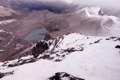
This is the ascent ridge. The glacier is on the right, and the horizon on the ridge is the top of the step. Descending proved harder than ascending, and my Dad lost it trying to detour on the glacier. He slipped but luckily his ice-axe kicked in the self arrest. After the ridge we ran across the bowl to the shoulder and chose a different gully than that which we used on the ascent. This one had much more scree. The scree proved absolutely perfect! What took us almost 2 hours to ascend took us but 15 minutes on the descent before finding our way back into the trees and following hopeless animal trails until we found an actual human trail which put us on the Wilcox Pass trail about 15 or 20 minutes from the trailhead. The drive out was once again filled with deer and elk for me, but a good dinner in Nordegg was a bit of reconciliation for not having completed our original plans of doing Nigel AND Wilcox. But Nigel certainly did give us a sense of accomplishment.
