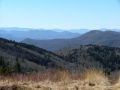
North Carolina's newest area for outdoor recreation is the DuPont State Forest. Several years ago, DuPont sold the land to a developer who planned yet another infestation of summer homes. Luckily, the state, with the assistance of the Nature Conservancy condemned the land, paid off the developer, and created a new state forest. This new area features over 100 miles of trail, mainly on old roads. It is a haven for hiking, mountain biking, and horseback riding, and it's easy to get to, being just outside of Hendersonville. We first visited the area in January of 2003. We did two short hikes on that trip, taking in 4 major waterfalls on the Little River. In doing so, we solved a longstanding mystery about the location of a waterfall filmed in "Last of the Mohicans".
Fungirl and I returned in August of 2003, brining her sister and 6-year old nephew with us. We car camped on the South Mills River, and hiked on Black Balsam Knob and had a swim at Sliding Rock. The highlight of the trip was a hike in DuPont along the Little River. Heavy rains had turned the stream into a flooded torrent that made the waterfalls even more spectacular than usual.
In February of 2004, we ended a weekend of car camping with a dayhike to Stone Mountain.
In January of 2006 Jack joined me for "The Ultimate DuPont State Forest hike" as we visited all of the major waterfalls on the Little River as well as Cedar Rock.
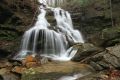
In January of 2008, Christy, Bob, and I hiked some new trails in DuPont, starting from the Fawn Lake Trailhead and passing Lake Julia, Bridal Veil Falls, and Cedar Rock.
In March, 2010, we returned to the area for a hike to all of the major waterfalls and Cedar Rock with Jack, Dave, and two friends from Denmark. (Photos)
In May, 2010, Christy and I spent the weekend in Asheville. We also did short walks to Pearson's Falls and in the gardens at the NC Arboretum. Photos.
In January, 2011 Jack and I explored Hogshead Creek and discovered two new waterfalls upstream from Maidenhair Falls. Photos.
In January, 2012 Jack, Brenda and I joined a CMLC hike from Camp High Rocks in Cedar Mountain to the summit of Rich Mountain. Afterwards, we hiked to Joanna Mountain in DuPont State Forest. Photos.
In March, Christy and I led a group of exchange students from Denmark, high school students, teachers, and parents on a hike in DuPont State Forest. Photos.
In June, 2012, Jack, Darrin, and I joined a CMLC hike to Connestee Falls and three waterfalls on Batson Creek. Later we explored Carson Creek and visited Silver Slip. Photos.
In January, 2014, Christy, Jack, Brenda, Jonathan, and Jess joined me for an exploratory hike to Reece Place Falls on the East Fork of the French Broad River. Photos.
In February, 2015 we returned to DuPont State Forest for a dayhike in the snow to Bridal Veil Falls. Photos.
Our March, 2017 hike in the snow to several waterfalls in DuPont State Forest near Hendersonville. Photos.
In December, 2017 we did a dayhike with the dogs to Triple Falls, High Falls, and Lake Julia in the snow in DuPont State Forest. (Photos)
Our November, 2018 hike to Bursted Rock Mountains and Dolves Mountain in Headwaters State Forest. (Photos)
My December, 2019 hike with Team Waterfall to all of the secret waterfalls in DuPont State Forest. (Photos)
My November, 2019 hike with the dogs to Stone Mountain in DuPont State Forest. (Photos)
Photos from a June Team Waterfall exploration of the South Prong of Glady Fork of the French Broad River, with Christy, Darrin, John, and the dogs. (Photos)
Photos from an August hike with Christy and Boone to the waterfall on Jane Cantrell Creek in Headwaters State Forest. (Photos)
Photos from a short September hike with Christy to Melrose Falls near Saluda. (Photos)
Photos from a February, 2021 return to Pink Falls in Project Oh! with Darrin, Bob, Jennifer, Thomas, Kitty, and John. (Photos)
Photos from a , 2021 exploratory hike in the Green River Game Lands with Jack, Jennifer, Brandi, Thomas, Scott, John, Justin, Amanda, and Zachary, including Amanda Falls, the Pace Cliffs, and Pace Yourself Falls. (Photos)
Photos from a March, 2021 short hike with Christy to check out the wildflowers along the trail to Melrose Falls. (Photos)
Photos from April, 2021 trail runs in DuPont State Forest and Pisgah National Forest. (Photos)
Photos from November, 2021 short hikes in DuPont State Park. (Photos)
Photos from a November, 2021 hike with Jack to our adopted waterfalls in the Green River Gamelands. (Photos)
Photos from a January, 2022 hike with Jennifer, Thomas, and Kitty near DuPont State Forest.
(Photos)
Photos from my January, 2022 exploration of a creek near DuPont State Forest with Jennifer, Thomas, and Kitty. (Photos)
Photos from my solo January, 2022 bike ride to Pinnacle Mountain. (Photos)
Photos from my February, 2022 exploration of a creek near DuPont State Forest with Jennifer. (Photos)
Photos from my March, 2022 creek exploration with Jack and Scott in Headwaters State Forest. (Photos)
Photos from my March, 2022 hike with Boone to Merry Falls and Christmas Falls. (Photos)
Photos from our August, 2022 visit to Hooker Falls, with a packraft trip to Cascade Lake. (Photos)
Photos from my October, 2022 bike rides in DuPont State Forest. (Photos)
Photos from my December, 2022 traverse of Stone Mountain and exploration of Dismal Creek with Jack, Jennifer, Scott, and Dillon. (Photos)
Photos from 3 different trips in DuPont in late April. (Photos)
Photos from a June solo exploration of an unnamed tributary of Grassy Creek in DuPont State Forest after 4 days of rain. (Photos)
Photos from a July, 2023 hike with Jackson to Cedar Rock in DuPont. (Photos)
Photos from a series of October, 2023 evening hikes, trail runs, and bike runs in DuPont State Forest at the peak of the fall foliage. (Photos)
|

Behind Bridal Veil Falls |