Spread out a Utah highway map, and let your mind go back a hundred, two
hundred years. Where those green, blue, and red lines run, long before the
ribbons of asphalt and concrete they represent crisscrossed the state, ran
the earlier highways of exploration and adventure.
Highway builders today seek the best combination of shortest distance and
easiest terrain. So too did the Spanish padres, the mountain men, the government
explorers, and the home-seeking pioneers who blazed and carved Utah's historic
trails. It is no accident that after the discovery of the easiest way over
the Continental Divide at South Pass, Wyoming, the major traffic into Utah
funneled down Echo Canyon, where Interstate 80 and the Union Pacific Railroad
now run. All or part of most Utah highways--all the major ones--follow trails
established by historic explorers and the Indians before them.
There are, of course, exceptions--trails that followed the shortest but
far from the easiest routes. Two major ones were born of ignorance and foolhardiness.
One, made by the 1879-80 Hole-in-the-Rock expedition that was attempting
to establish a Mormon settlement on the San Juan, is a carved trail through
southeastern Utah country so savage it is still negotiable only by the most
strenuous jeeping and hiking. The other exception, far more tragic, was
the route followed by the California-bound Donner-Reed party of 1846. Lured
by a California promoter, Lansford Hastings, who promised they could save
400 miles of travel, they left the known trail at Fort Bridger and cut a
trail (to be followed the next year by the Mormons) down Echo Canyon, over
Big and Little mountains, and into Salt Lake Valley. Continuing west, they
skirted north of the Stansbury Mountains, then struck out across the Great
Salt Lake Desert for Pilot Peak, eighty miles away. John C. Frémont,
the famed government explorer, had crossed that way in 1845. So also had
the mountain man Jim Clyman with Hastings in 1846. So also would a detachment
of the Mormon Battalion in 1847, a military survey crew under Howard Stansbury
in 1849, and possibly a few California-bound gold-seekers, who left no record,
in the same year. So the eighty waterless miles of salt flats could be successfully
crossed--but not easily by wagons. The Donner-Reed party bogged down in
the sticky mud, abandoned four of their wagons, lost many of their oxen,
and barely escaped the desert with their lives, only to face starvation
and cannibalism in the Sierra Nevada.
For the most part, however, blazers of the trails through Utah generally
chose routes now followed by highways or, at least, dirt roads. That was
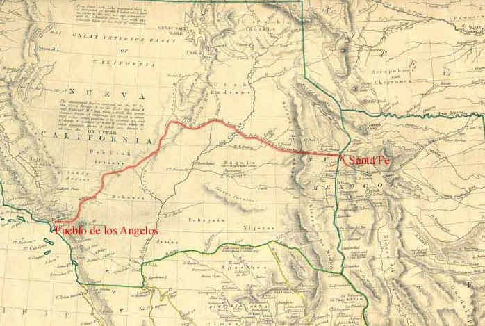
especially true of two major routes--the Mormon and the old Spanish trails--both
of which are described in detail elsewhere in this volume.
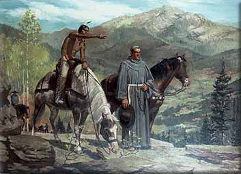
It was mostly true of the first Utah trail known to history--that of the
Dominguez-Escalante expedition. In 1776, those two padres, seeking a route
to link the Catholic missions of New Mexico with those of southern California,
traversed Utah from its northeastern to its southwestern corner, entering
the state at Jensen and reaching the vicinity of St. George before turning
east to find a way home. The only three areas where present roads do not
generally follow their route are also those areas where they had the greatest
difficulty. One was where they fought their way over the Wasatch Mountains
from the vicinity of Strawberry Reservoir to reach and preach to the Indians
at and around Utah Lake. Another was where they suffered in the bitter cold
and almost impassable mud of the Escalante Desert. And the third was where
they blundered across the redrock desert of southern Utah and northern Arizona
before finally finding a way across the gorge of the Colorado River at the
Crossing of the Fathers. They failed in their effort to establish a trail
to the California missions; that would wait half a century, with the development
of the old Spanish Trail. Their pleas for the establishment of missions
among the Indians of Utah's central valleys went unheeded; otherwise Utah's
culture today might well be Spanish-American rather than Mormon.
The greatest trailmaker to tread Utah soil was Jedediah Smith, the literate
young fur trader who accomplished an incredible number of firsts--first
to open South Pass to western emigration, first to travel the north-to-south
length of Utah, first to reach California from Utah soil, first to cross
the Sierra and the Great Basin, first to traverse the California and Oregon
coasts to the Columbia River. In 1826, as a new owner of William Ashley's
fur company, he set out to explore to the south and west, looking for beaver,
and, as he said, "to view a country on which the eyes of a white man
had never gazed and to follow the course of rivers that run through a new
land." That quest would take him on not one but two round trips to
California. The first, in 1826, followed the present routes of U.S. Highway
91 from southern Idaho through Cache Valley and on to Utah Lake, highways
6 and 10 into and through Castle Valley, I-70 to Salina and Cove Fort, and
I-15 to Cedar City, St. George, and on to California. Only on his return
trip, after a terrible mid-winter crossing of the Sierra Nevada Range and
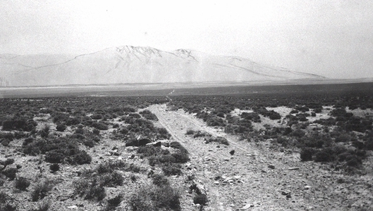
the Great Basin, did he blaze a Utah trail where roads do not now follow--in
the desolate western desert, now part of Dugway Proving Grounds, where he
and two companions nearly perished before reaching the springs where Iosepa
was later built. His second trip, starting just ten days after the first
ended, followed much the same route, except that he swung east of the Wasatch
past Bear Lake (along the routes of present highways 89, 16, I-80, and 189)
and skipped the loop into Castle Valley. That trip was a disaster. Ten of
his men were killed by Mojave Indians as they crossed the Colorado River
in southern Nevada, and fifteen others were killed by the Umpquas in southern
Oregon. Smith himself died at the hands of the Comanches four years later
on the Santa Fe trail. He was thirty-one.
Utah's main north-south route--originally the Arrowhead Highway, then Highway
91, then I-15--was developed gradually. The Dominguez-Escalante expedition
was the first on it, traveling from Utah Lake to present-day Scipio. Jedediah
Smith traveled most of it in 1826 and 1827, and other trappers, including
Ewing Young, Kit Carson, and Peter Skene Ogden, followed. John C. Frémont
mapped the country up to Utah Lake in 1844, and in 1848 Miles Goodyear took
a pack train over the entire Salt Lake-Los Angeles route. But the first
wagon was dragged over the trail in 1848 by Mormon Battalion members returning
to Salt Lake Valley after mustering out in Los Angeles. And it was a former
Battalion member, Jefferson Hunt, who in 1849 led the first party to make
it an actual wagon road. Many gold-seekers bound for California had reached
Salt Lake City too late in the season to cross the Sierra Nevada. Hunt offered
to take them on a new southern route in 1849 to Los Angeles, from where
they could travel north to the gold fields. Some 500 emigrants with 100
wagons accepted the offer, at ten dollars a wagon. Disgruntled with the
slow pace and the road-building effort, and suspicious of Hunt, most of
them elected to take a shortcut west from Enterprise. They got into trouble
in the Beaver Dam Mountains, and most returned to the trail. Of those who
didn't, a number died in the Death Valley region, while those who followed
or returned to Hunt reached California safely.
Another wagon road built mainly by homeward-bound Mormon Battalion veterans
was the Salt Lake Cutoff of the California Trail. From Salt Lake City it
ran north along the present route of I-15 to the vicinity of Snowville,
then west to the Raft River and City of Rocks area just north of the Utah-Idaho
border, and on west to the Humboldt River in Nevada.
The storied but short-lived Pony Express in 1860-61 followed the main emigrant
trail down Echo Canyon into Salt Lake Valley. Interstate 80 now follows
most of that route. That a major highway doesn't follow much of the route
west to the Nevada border may be due to a little-remembered political tug-of-war.
In 1913 auto and tire companies formed the Lincoln Highway Association and
contracted with states along the proposed to build a transcontinental highway.
The route was to skirt south of the Great Salt Lake Desert to Ibapah on
the Nevada border, proceed on to Ely, and there divide, one branch swinging
south to Los Angeles, the other continuing west to San Francisco. But Utah
officials wanted the route to divide at Salt Lake City, not Ely. So the
state put its money into what became Highway 40 across the salt flats to
Wendover, never finishing its section of the Lincoln Highway along much
of the old Pony Express route. The dispute scandalized the nation, but the
proposed route remains a dirt road through the desert.
William B. Smart, Old Utah Trails (1988).
William B. Smart