MAPS
These pages are a “map
study” Special4u by PAT
combining useful, beautiful and interesting
maps.
The
URL internet address of this MAPS page is:
https://www.angelfire.com/space/special4u/maps.html
as
mentioned at pages:
normal speed
SPECIAL 4u High
Speed SPECIAL 4u
http://www.special4u.50megs.com special4u.50megs.com
special4u.50megs Google special4u
If you see mal-functioning links, or anything wrong on this
page,
or anything that can be better, please send an email
about it to:
wetry2@gmail.com pierretours@yahoo.com
Double
checking your search keywords at sites as
Google, Wikipedia, Wiktionary, Yahoo,
YouTube, Special4u...
might complete the
results you are looking for.
Maps Weather Travel
Page
presented by Pierre
André THIBAULT,
PAT
in
Copenhagen, Denmark, August 2004,
with Copyrights for the copied, printed,
or reproduced articles, texts,
pictures,
maps, and URL internet addresses as
mentioned above and below.
After 2006, any text, picture, video, by
Ew Jo An Ia Jos Pim Joj Had Mus Car Pia
Vid Maud Dest Graf Pin Ser Bod Ren EKWI
is free of Copyrights © if for
“non-commercial or non-political use”.
Any
creation under these names or
pseudonyms can be considered
as
“free stuff” or “Open
Source”
material if
“not for making money”
or
political propaganda.
For reference to, or for copying from any item
from this
site, we thank you if you just cite
or quote Special4u as your source, or simply
link to it.
For
example, the source of much of the
information
on this page is from:
Microsoft Linux
Unix Apple Alexa
Yellow
White Pages Skype EQO TPB
A site also for
Travel, Languages, Countries, Regions
Before
any travel, voyage, vacation, holiday, trip,
it
is recommended reading some info about:
Human
sexual behaviour Sexually transmitted disease
Hormones Steroid sex Testosterone E2
Birth control Vaccination Travel insurance
Some useful Basic
Research Tools
for newbies, beginners & nerds:
Countries digital
access Sitemap
more
tools 4u Special4u TRAVEL
Google Wikipedia Wiktionary Yahoo YouTube
Apple Microsoft msn Live Facebook Myspace Twitter
Hi5 Orkut
Fotolog
Flickr ebay amazon
Alexa
YP TPB Skype
EQO PayPal SitePal Nasdaq DJ
Clock GMT
Date Time zones Countries
Tel dialling codes
Internet country codes +
Real Time World
Statistics
Statistics OECD Economic
trends CLI for 2008
GOOD for you Life quality Quality of life
by Country
Flight booking Euro flights-Flying private
By train-road By sea-river Hotel booking
Lonely PLANET Travel & Countries
HOTELS - ACCOMMODATION - LODGING
RESTAURANTS - FOOD - DRINK - BEVERAGES
Some ways to get somewhere in Europe
Language, culture, networks, communities: European Tours 4u
Special Paris Tour
4u
at
Google at
Yahoo
Special Excursions, Travel, Trips 4u at
Google at
Yahoo
Social networking Communities Photo sharing Video
sharing
Probably an absolute top European travel, food, and drink site.
Click here or on this map
and on each of the red dots to see the Prehistoric Venus places
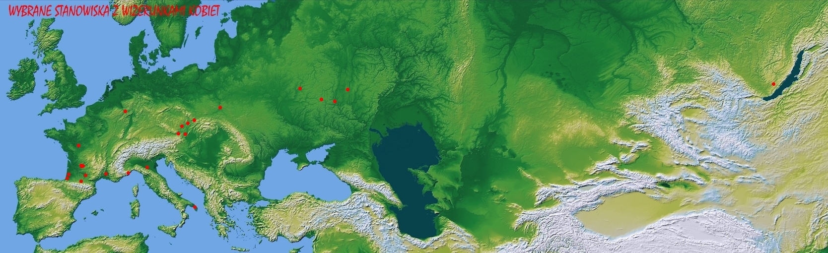
This map blown-up
as a jpg (48105 byte) or file (752 k)
from an excellent Polish Prehistoric site with
More Info
Prehistoric
References Euro Man
Euro Venus for High Speed Broadband Bandwidth
VENUS
for normal speed internet connection
born in Rupelmonde, Antwerpen, Belgium - 1512-1594
MULTIMAP search Belgium
Rupelmonde
http://mathsforeurope.digibel.be/mercator.htm
http://en.wikipedia.org/wiki/Gerardus_Mercator
http://www.folger.edu/institute/course_03.cfm
http://www.megaliths.net/mercator.htm
http://www.trabel.com/oostende/oostende-tourist.htm
http://www.castenmaps.com/mercatoro.html
http://www.davidrumsey.com/maps510.html
http://www.betzmaps.com/AF-130.html
http://www.philaprintshop.com/hungary.html
In PAT’s Personal
Record - CV click on Le Monde,
an
English translation of this press article in the
French
“Le Monde” by Pierre Thibault,
and more
info
about the French sea charts and world maps
of La Pérouse, J B de Lesseps, and Dumont d’ Urville,
can
be supplied to interested readers, researchers, and
students.
Jacques-Nicolas
Bellin Jacques N Bellin
French cartographers
The
French engineer and cartographer Rigobert
Bonne 1727-1795,
succeeded
J.N.Bellin as an Hydrographer at the Dépôt
de la Marine,
1773.
Earth science Physics Geology Geography Meteorology
Geography Geography Cartography Cartographers
by nationality
Rare, Original Antique Maps
& Sea Charts
Country Maps and much info:
Google Earth MULTIMAP MAPPOINT MAPQUEST
LIBERO MAPS Western EU Regions LONELY PLANET
http://www.lib.utexas.edu/maps
Most Maps
Maps organized by European,
RIVIERA MAPS French Atlantic
Coast
UK United Kingdom Great Britain England
Wimbledon Ascot Royal
Ascot Ladies Day at YT
Regions
of England Greater London London
Cornwall
Sussex Kent Kingdom
of Kent Scotland Wales
Motorway Motorway
traffic at Google
Automobile
clubs UK at Google RaC
DfT HIGHWAYS Traffic BBC motorways
TrafficMap
Flow Services AA AA FRIXO
every ½
hour at GMT + 1
on seasons
at present Greenwich Mean Time
http://wwp.greenwichmeantime.com
of much of
http://www.redtailcanyon.com/items/18195.aspx?imageId=36298
https://www.angelfire.com/space/special4u/nightlight800pixel.jpg
Satellite
photo of
Can
also be considered as “light pollution”.
Red
dots are showing flames from oil derricks
in
Photo
supplied to Aftonbladet,
by
IBL Bildbyrå, in 1997.
Earth from Space with a Clickable
Map
of
just where you are
from NASA
Earth
Lights from NASA
at:
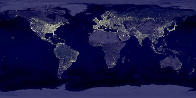
http://antwrp.gsfc.nasa.gov/apod/ap001127.html
on:
https://www.angelfire.com/space/special4u/earthlights_dmsp.jpg
An
example about Cycling and Photo, Colour Depth,
Page
Loading, Connection Speed, Cascading Style Sheets,
and
JavaScript
EU Euractive Western EU regions
Belarus Byelorussia Russia Ukraine
Perhaps Future EU Southern Regions
Railway - Coach - Bus - Roads -
Motorways - Highways - Ferries...:
Some ways to get somewhere in Europe
Railway Coach Bus Roads
Motorways
http://www.google.com/search?hl=en&q=Worldwide+railways++map&btnG=Google+Search
Worldwide Railways Map at Google
Some railway track maps
NORVEGIAN
RAILWAYS Timetables &
MAPS NSB
Timetables &
MAP info available at local tourist office
http://www.vildmark.se/info.asp?id=70
Adventure path in Sweden
HORNBORGASJO 150 000 visitors every year,
a few days in
March-April for the cranes’
mating dance, colourful
ballet in the open.
MAP and info available at local
tourist office
Cranes mating dance with beautiful photos
Hornborgasjön Maps Birding many
Links
at YT YT YT YT see related videos
DANISH
RAILWAYS http://www.dsb.dk DSB
http://www.virtualdenmark.dk/map_denmark.html
Simple Map of
Road and itinerary planning by the Danish Yellow Pages
De Gule Sider Kortbog Rutevejledning
ORESUND
and BRIDGE STORE
BAELT BRIDGE
GERMAN
RAILWAYS http://www.bahn.de DB
NETHERLANDS RAILWAYS
http://www.ns.nl NS
BELGIAN RAILWAYS
http://www.b-rail.be B
LUXEMBURG
RAILWAYS http://www.cfl.lu CFL
POLISH RAILWAYS http://www.pkp.pl PKP
CZECH RAILWAYS http://www.cd.cz CD
SLOVAKIAN RAILWAYS http://www.zsr.sk ZSR
HUNGARIAN RAILWAYS http://www.mav.hu MAV
ROMANIAN
RAILWAYS http://www.cfr.ro CFR
BULGARIAN RAILWAYS http://www.bdz.bg BDZ
and some related topics
List of many railway companies
SWISS RAILWAYS http://www.rail.ch SBB
CFF FFS
Swiss Geography, main roads and highways
FRENCH RAILWAYS http://www.sncf.com SNCF
ITALIAN
RAILWAYS http://www.trenitalia.com TREN ITALIA
Excellent site, excellent Elba Maps!
AUSTRIAN RAILWAYS http://www.oebb.at OEBB
SLOVENIAN
RAILWAYS http://www.slo-zeleznice.si SZ
SPANISH RAILWAYS http://www.renfe.es RENFE
PORTUGUESE RAILWAYS http://www.cp.pt
CP
UK RAILWAYS http://www.rail.co.uk
IRISH RAIL http://www.irishrail.ie
Turkey and Turkish Railway maps
http://www.adiyamanli.org/MapofTurkey/turk_map.htm
Map of
some Cartography and Cartographers
by nationality
related topics in millions:
http://www.ucmp.berkeley.edu/geology/anim1.html
Continental Drift - Plate tectonics
animation
http://www.tacitus.nu/historical-atlas/scandinavia/dk1.htm
Nordic History from Ice Age
http://www.tacitus.nu/historical-atlas/scandinavia/dk1.htm
Maps of
http://www.tacitus.nu/historical-atlas/scandinavia/denmark.htm
Historical
Atlas of
Kings of
the eldest European Monarchy still reigning
Some Danish
tribes with Roman names
in
http://www.esd.ornl.gov/projects/qen/bw6.gif
Map of
http://www.pik-potsdam.de/research
The Potsdamer PIK supplies a Map of coldest Air Temperature
during last Ice Age, back soon ?
http://www.tacitus.nu/historical-atlas/scandinavia/ice_age.htm
Last Ice Age in
Siberia from the last Glacial
Epoch
http://geology.cwru.edu/~huwig/catalog/humanpaleontology.html#sites%20in%20caves%20and%20gravels
http://cwx.prenhall.com/bookbind/pubbooks/stokstad3/chapter1/custom4/deluxe-content.html#B1
European Prehistory
http://www.republika.pl/nihilum/stronamapa.htm
Map
of Prehistoric Venus Sites
http://freepages.genealogy.rootsweb.com/~allpoms/genetics4.html#6.1
DNA and Human Origins
http://freepages.genealogy.rootsweb.com/~allpoms/genetics3.html
DNA Human Origins
http://www.ac.wwu.edu/~stephan/Animation/alexander.html
Alexander Animated Map
Maps of Greek Regions and
http://www.intercyprus.com/cyprus_map.html
Greek map of Cyprus
http://www.greatestcities.com/Middle_East/Cyprus.html
Greek Turkish UN and
http://www.dalton.org/groups/rome/RMap.html
http://www.acs.ucalgary.ca/~vandersp/Courses/maps/basicmap.html
Greatest
http://www.historylink101.com/ancient_rome/ancient_rome_maps.htm
Roman Maps
Some maps of the Roman Empire
http://www.viaeromanae.com/index.php3?langue=fr&id_gmenu=1527
Viae Romanae
http://www.dl.ket.org/latin3/mores/techno/roads/map.htm
Main Roman Empire Roads
http://www.dalton.org/groups/rome/Germania.html
Germania
http://www.tacitus.nu/historical-atlas/scandinavia/dk1.htm
Nordic History from Ice Age
Roman towns and cities by country
A
al-Idrisi's
world map 1192 A.D.
Southern
Africa,
the first time
on the Map of the
by the
Portuguese Cartographer Jorge Reinel 1502-after
1572
The oldest printed map of Mauritius
Delineatio Insvlae do Cerne,
Alias Mavritivs Dictae,
On this Map of
can be seen at the far right
"Carte Particuliere de l'Isle de France", by
the important
French
engineer and cartographer
Rigobert Bonne 1727-1795, who succeeded J.N.Bellin as
Hydrographer
at the Depot de la
Marine,
1773. A very detailed map of
century
name Isle de France with key place names and much
topographical
detail. The map is part of the "Atlas de Toutes
Les Parties Connues de Globe Terrestre" that
accompanied
G. T. F. Raynal’s ten volume, L’histoire philosophique…
This
map is also Plate 88 of Bonne's
"Atlas Encyclopédique",
Agalega Islands, Mauritius,
Indian Ocean
Ancient maps from these 6 previous sites are
no longer
available through The
Mauritian Encyclopaedia.
Ask for internet copies here
Double
checking your search keywords at sites as
YouTube, Google, Wikipedia, Wiktionary, Yahoo,
Special4u...
might complete the
results you are looking for.
Anything from this page can be copied, printed, or
reproduced freely if not for commercial, business,
or political use.
If you see mal-functioning links, or anything wrong on this
page,
or anything that can be better, please send an email
about it to:
wetry2@gmail.com pierretours@yahoo.com
The
URL
internet
address of this MAPS page is:
https://www.angelfire.com/space/special4u/maps.html
Back to:
http://www.special4u.50megs.com
special4u.50megs Google
special4u