
The axial tilt undergoes a slow oscillation. The earth's obliquity, which is currently 23.44°, is believed to vary between about 21.6° and 24.6° over a period of 41,000 years. These values are based on calculations of the gravitational interaction between the planets. The earth's tilt is currently decreasing and it is believed to have been doing so for the past 10,000 years. Since it is the tilt of the axis that produces the cycle of the seasons, this means that the differences between the seasons are less extreme now than they were 10,000 years ago summers are a little cooler and winters are a little warmer.
The axis of each planet in our solar system has a different angle of inclination: Mercury 0°, Venus 177°21', Earth 23°26', Mars 25°12', Jupiter 3°07', Saturn 26°44', Uranus 97°46', Neptune 27°52', and Pluto 119°37'.
Venus, Uranus, and Pluto are therefore 'upside down' to some extent, and have a retrograde rotation about their axis, i.e. they rotate clockwise as viewed from 'above' the solar system. The sun's axis is tilted at an angle of 7°15' to the ecliptic. The moon's axis is tilted at an angle of 1.5°.
The accumulation theory of the solar system provides an explanation of the direction of revolution and rotation of the planets. Verschuur speculates that during the earth's formation, a large neighbour slammed into the earth so that its axis was tilted.
George Williams challenges the view that the obliquity of the primordial earth was less than 10-15° and has slowly increased due to tidal friction. He says that the primordial earth acquired an obliquity of about 70° from the alleged giant impact that produced the moon, and that the obliquity remained above 54° for most of the Precambrian. The polar regions would have received more solar energy than the equator and glaciers would have grown in low latitudes while the poles stayed ice-free; during the late Proterozoic glaciation (800-600 million years ago), continents at low palaeolatitudes were glaciated. He holds that the obliquity decreased relatively rapidly from about 60° to about 26° between 650 and 430 million years ago, but has not changed much since then. He claims that this scenario is supported by the climate record.
Although the general view is that during the Phanerozoic (the last 540 million years), normal climatic zonation has prevailed on earth, and there is no evidence for significant departures of the obliquity beyond the supposed current limits of about 21.5-24.5°, some scientists say palaeoclimatic and palaeontological data suggest that in the Mesozoic and early Cenozoic the earth's tilt was only 5 to 15°.16
Several scientists maintain that many of the other planets are subject to changes in obliquity. Mechanisms are said to include tidal torques, dissipative core-mantle coupling, planetary impact, resonant axial-orbital precession, and a twist of the orbital angular momentum vector. Some scientists hold that the inclinations of spin axes have undergone variations due to the gravitational pulls of the other planets. Based on detailed orbital calculations none of the inner planets (Mercury, Venus, the Earth and Mars) can have primordial obliquities, and all these planets could have been formed with a near-zero obliquity. The obliquities of the outer planets (Jupiter, Saturn, Uranus, and Neptune) are stable, and can be considered as primordial, that is, with about the same value they had at the end of the formation of the Solar System.
In the absence of the moon the chaotic zone for the earth's axis would extend from 0° to 85°.

A rotating irregular sphere (such as the earth) has angular momentum (II). The sphere, having mass, therefore has a moment of inertia (I). In the diagram (below, right) II1, II2 and II3 represent the angular momentum components of the sphere on orthogonal axes. The components of the moment of inertia are I1; I2; I3.
Introduction to Mechanics and Symmetry by Marsden and Ratiu

True polar wander is a phenomenon in which a planet or moon changes its orientation so that different points become the North and South Poles. This can happen when the two larger moments of inertia are near equal.
The Earth is not a true sphere, and therefore has three orthogonal axes of inertia. The axis around which the moment of inertia is greatest is closely aligned with the rotation axis (the axis going through the North and South Poles). The other two axes are near the equator.
But if the moment of inertia around one of the two axes close to the equator becomes nearly equal to that around the polar axis, then the constraint on the orientation of the object (the Earth) is relaxed. Small perturbations can move the sphere so that it spins around another axis through this same "equator". In the same way, when the conditions are right, the Earth (both the crust and the mantle) can slowly reorient so that a new geographic point moves to the North Pole, while keeping the axis of low moment of inertia quite near the equator. Such a reorientation changes the latitudes of most points on the Earth, by amounts that depend on how far they are from the axis near the equator that does not move.
Wikipedia says cases of true polar wander have occurred several times in the course of the Earth's history. The speed of rotation (around the axis of lowest inertia) is limited to about 1° per million years. Mars, Europa, and Enceladus are also believed to have undergone true pole wander, in the case of Europa by 80°, flipping over almost completely. The crust of Titan has also shifted, though pole wander has not been detected.
There are two types of polar wander:
1) geographical (or true) polar wander: a shift of the entire earth or some part of it (lithosphere, lithosphere + mantle) relative to the spin axis, resulting in a change in the position of the geographic poles on the earth's surface. Lines of longitude join at the geographic poles.
2) magnetic polar wander: the movement of the magnetic poles with respect to the geographic poles.
The magnetic poles are believed to drift slowly westward around the geographic poles, returning to their original position after a period of a few thousand years. Palaeomagnetism studies the direction and inclination of the magnetic field of various iron-bearing minerals in rocks, such as magnetite in basalt, to ascertain the location of the poles at the time the rocks were formed. Pole locations calculated from measurements on rocks younger than 20 million years do not depart from the present locations. Going back more than 30 million years reveals successively greater distances and an apparent polar wander path (APW). Different continents yield different polar wander paths, so it was concluded that it was the continents that wandered, though some degree of true polar wander (TPW) has not been ruled out.
It is assumed that over long periods of time the magnetic poles will tend to coincide with the geographic poles. However, the geomagnetic field at the present time deviates substantially from that of a geocentric axial dipole. The magnetic axis is tilted by about 11° to the rotation axis.
Four earth axes can be distinguished
1) The geographic axis is the line joining the north and south poles, the points of origin for the lines of longitude.
2) The rotation axis or the earth's spin axis.
3) The axis of maximum moment of inertia: the axis of symmetry of the earth's spheroid, determined by the distribution of mass within the planet.
4) The magnetic axis, the north and south line of the earths vortex.
Of these the first three axes are so close together that they can be thought of as coinciding. In reality, however, the axis of maximum moment of inertia is not exactly coincident with the axis of rotation, and this gives rise to tiny polar motions.
Two discrete periodic oscillations can be distinguished:
Chandler Wobble has about a 14-month period [428 days], and the other has a 12-month period. The combination of these two wobbles causes the poles to trace spiral paths out, around and back to their mean positions over a period of about 6.5 years. The Chandler wobble is thought to be related to earthquakes, surface wind loads, solar activity, and geomagnetism.
The only perfectly stable state of rotation for a planet occurs when it rotates about its axis of maximum moment of inertia. An internal redistribution of mass, or a comet or asteroid impact, drags the axis of maximum moment of inertia away from the rotation axis, creating an unstable condition. The rotation axis then tries to realign itself with the maximum moment of inertia axis. The maximum moment of inertia axis precesses about the rotation axis in an ever-decreasing spiral until the two axes again coincide. Strictly speaking, the position of the maximum moment of inertia axis is never exactly constant. The weather systems, ocean tides, and even the movement of animals and humans all alter the earth's mass distribution and therefore the position of the maximum moment of inertia axis.
Throughout the 19th and early 20th centuries, polar wandering was invoked to explain the evidence for former higher temperatures in the polar regions and former ice sheets at low latitudes. Such phenomena is now explained by continental drift, but some scientists believe that polar wandering has also taken place.
In the 19th century prominent scientists argued that polar wandering of more than a degree or two was impossible owing to the assumed rigidity of the earth and the stabilizing effect of the equatorial bulge. Evidence that the earth is not perfectly rigid was provided by minor tides in the earth's crust caused by the influence of the moon and sun, and by the discovery of the Chandler wobble in 1884-85.
In 1955 Thomas Gold postulated that large-scale polar wandering could be expected to occur over geological periods of time in a plastically deformable earth. The rotation axis could migrate 90° over a period of about a million years. He stated that if the earth were a perfect sphere instead of a flattened spheroid, "the smallest beetle walking over it would be able to change the axis of rotation relative to markings on the sphere by an arbitrarily large angle. The axis of rotation in space would change by a small angle only".
If the material forming the earth yields by flow under stress differences of arbitrarily small magnitude, then polar wandering will occur in response to any exciting force, however small (including that caused by Gold's beetle). However, if the material has a non-zero yield stress, polar wandering will take place only when the excitation stress is sufficient to exceed the threshold.
Munk and MacDonald pointed out that if significant polar wandering were possible, the poles should move so as to place the continents as well as possible on top of the equatorial bulge. The present distribution of the continents ought to place the pole in the vicinity of Hawaii in the equatorial Pacific about as far from the present pole as it can get. The fact that the pole is not in the Pacific nor travelling towards it at the expected rate suggests the earth (or at least its outer shell) has sufficient finite strength to withstand the stresses imposed by the continent-ocean system. However, this conclusion can be avoided by assuming that the stresses in question are balanced by just the right distribution of mantle inhomogeneities. If so, changes in the distribution of mass on or in the earth could conceivably trigger polar wandering, though it is also possible that the earth has enough strength to prevent this. The fact that major gravity anomalies are associated with Palaeozoic mountain chains indicates that major stress differences can persist for very long periods.
The general consensus, based on palaeomagnetism, is that polar wandering has been small probably less (perhaps much less) than about 20° over the past 200 million years, and less than about 10° over the past 80 million years.11 In this view, most of the wandering of the (magnetic) poles implied by palaeomagnetism is explained in terms of continental drift/plate tectonics. An alternative model (wrench tectonics) has been developed by Karsten Storetvedt, who accepts the validity of palaeomagnetism (while admitting it faces many problems) but rejects continental drift. He explains the palaeomagnetic data in terms of in-situ rotations of continental blocks and true polar wander; he argues that the poles have wandered 70° since the mid-Paleozoic, including a 30-35° latitudinal shift around the Eocene-Oligocene boundary.
Palaeomagnetic data are not reliable enough to support theories of large-scale continental drift or polar wander. Moreover, the evidence that the earth possesses sufficient strength to make significant polar wandering impossible is largely ignored. It is true that the polar motion record collected by the International Latitude Service since 1900 indicates that in addition to the 14-month Chandler wobble and the 12-month annual wobble, the rotation pole has a secular drift of about 0.95° per million years towards eastern Canada. But there is no certainty that such motion will continue in the same direction for many millions or tens of millions of years.
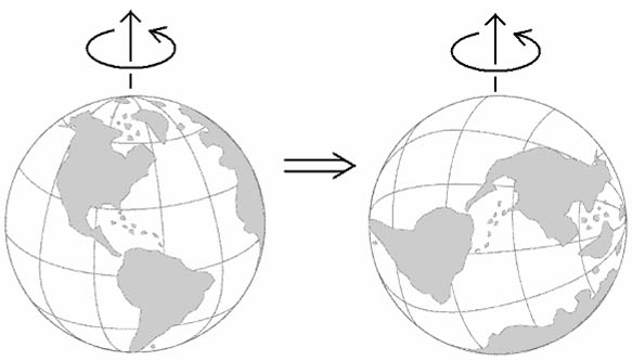
J.L. Kirschvink has argued that the Cambrian explosion was perhaps stimulated by a previous "Snowball Earth", when the entire Earth was frozen over. He has also argued that this evolutionary explosion may have been precipitated in part by true polar wander, which occurred from 535 to 520 million years ago, as a result of a major reorganization of tectonic plates that changed the balance of mass within the earth. The entire lithosphere and mantle rotated about 90°, so that the regions what were previously at the north and south poles were relocated to the equator, and two antipodal points near the equator became the poles. This hypothesis is based mainly on palaeomagnetic data and is therefore highly dubious.
Several scientists see evidence of polar wandering on the moon and Mars. Kirschvink states, 'The Tharsis volcanic province on Mars, with the largest positive gravity anomaly known from any planet, appears to have reoriented the martian lithosphere to place Tharsis on the equator; similarly, the lunar mascons all lie facing Earth symmetrically about its equator.'
http://ourworld.compuserve.com/homepages/dp5/pole2.htm
The nearest thing in Oahspe to what we understand as pole shift is contained in these lines.
8. The greater diameter of the vortex is east and west; the lesser diameter north and south, with an inclination and oscillation relatively like the earth.
9. The name of the force of the vortex is called vortexya, that is, positive force, because it is arbitrary and exerts east and west (i.e., at right angles to the axis). As in the case of a wheel turning on its axis, its force will be at right angles with its axis, at the extreme center of which will be no force.
10. For which reason the north and south line of the earths vortex is called the mvortexya, or negative force, for it is the subject of the other. As a whirlwind gathers up straw and dust, which travel toward the center of the whirlwind, and to its poles, so do corporeal substances incline to approach the poles of the earths vortex. Which may be proved by poising a magnetized needle.
11. In the early times of earths formation, the earth was longer north and south than east and west. But the mvortexya, being less than the vortexya, the earth assumed the globular form, which was afterward attenuated east and west, then the earth turned again, to adapt itself to the north and south polarity of the vortex.
12. In these various turnings of the earth, the same force of the vortex exerted ever to the east and west. By which behavior every portion of the earth has been to the east, to the west, to the north, and to the south.
13. Which is proven in the rocks, and boulders, and mountains of the earth. And for that reason it is shown there is no north and south polar power in the earth as such. Furthermore the iron mountains show they attract from all directions, without any regard to a central polar force in the earth itself.
In the case of 'true polar wander' the earth turned over a period of 15 million years while the earth's spin axis remained oriented in the same direction. This event has occured once in the geologic history of the earth, and has left a paleomagnetic record in rocks.
You might want to go directly to the website for it ...... http://www.gps.caltech.edu/~jkirschvink/
True Polar Wander and Cambrian
The name of the period at the end of the Neoproterozoic era was referred to as the Vendian, but is now known as the Ediacaran period. The Ediacaran/Vendian and Cambrian (shown in pink below) are those periods on either side of the Neoproterozoic to Paleozoic era partition. This partition also marks the greater transition of the Proterozoic eon (during which the build-up and transition to an oxygenated atmosphere coincided with the first advanced single-celled and multi-cellular life forms) to the Phanerozoic eon, the current eon during which abundant animal life has existed.
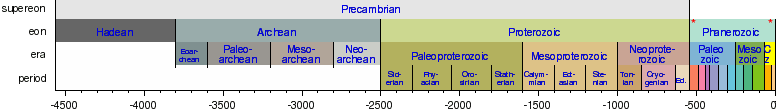
This latest Neoproterozoic through Cambrian is one of the most remarkable intervals in geologic time. Tectonically, the period from 580 to 490 Ma marks a time of rapid plate reorganization following the final stages of supercontinental breakup and Gondwana assembly. The Proterozoic geological eon (2500-542 million years ago, the most recent part of the Precambrian time) represents the period before the first abundant complex life on Earth (Cambrian period when the first fossils of trilobites and archeocyathids appeared).
The apparent speed at which this reorganization occurred led some to propose a link between tectonic events, biologic changes and climatic changes. One of the more intriguing proposals is that the tectonic changes were triggered by an episode of inertial interchange true polar wander (IITPW) which resulted in a rapid (6°/m.y.) shift of the spin axis relative to the geographic reference frame. IITPW is a special case of true polar wander (TPW) that makes specific demands on the length of apparent polar wander paths (APWPs) recording the motion. Specifically, each path must allow for 90° of synchronous motion during the interval from 523 to 508 Ma. A review of paleomagnetic data for Laurentia, Baltica, Siberia and Gondwana indicates that none of the APWPs approaches the necessary length, each path is of a different length and the apparent motions are non-synchronous. Collectively, these observations negate the premise of a Cambrian IITPW event. The motion of continents relative to the Earth's spin axis may be due either to rotation of the entire Earth relative to its spin axistrue polar wander, or to the motion of individual plates. Over the past 320 Myr (since the formation of the Pangaea supercontinent) using a palaeomagnetic reference frame, two components are identified: a steady northward motion and, during certain time intervals, clockwise and anticlockwise rotations, interpreted as evidence for true polar wander. We find 18° anticlockwise rotation about 250-220 Myr ago and the same amount of clockwise rotation about 195-145 Myr ago. In both cases the rotation axis is located at about 10-20° W, 0° N, near the site that became the North AmericanSouth AmericanAfrican triple junction at the break-up of Pangaea. This was followed by 10° clockwise rotation about 145-135 Myr ago, followed again by the same amount of anticlockwise rotation about 110-100 Myr ago, with a rotation axis in both cases 25-50° E in the reconstructed area of North Africa and Arabia. These rotation axes mark the maxima of the degree-two non-hydrostatic geoid during those time intervals, and the fact that the overall net rotation since 320 Myr ago is nearly zero is an indication of long-term stability of the degree-two geoid and related mantle structure. We propose a new reference frame, based on palaeomagnetism, but corrected for the true polar wander identified in this study, appropriate for relating surface to deep mantle processes from 320 Myr ago until hotspot tracks can be used (about 130 Myr ago).
Inertial Interchange True Polar Wander (IITPW) has been suggested as a possible mechanism for the rapid continental motion associated with the Vendian-Cambrian transition (~600 to 500 Ma) [1]. A True Polar Wander (TPW) event involves the reorientation of the maximum moments of inertia with the spin axis. As a consequence, the largest mass anomalies tend to become located about the rotational equator. Rigid body ?ow on the angular momentum sphere. In the motion of a free rigid body, rotation about the long and short moment of inertia axes is stable, and rotation about the middle axis is unstable. This can be understood as the motion of the rotation of the rigid body can be visualised as the ?ow along the intersections of the energy ellipsoid and the angular momentum sphere. As seen above, the paths about the long and short moment of inertia axes are closed, while the path about the middle axis corresponds to a saddle point.
An IITPW event occurs when the intermediate and maximum moments of inertia cross due to the redistribu- tion of mass anomalies. This causes the rotation motion of the earth to become unstable as it is about the middle axis, thereby causing a catastrophic shift of the axis of rotation. This can be understood in terms of the pedagogic theorem by Goldreich and Toomre [2], which states that the solid angle traced out by its angular momentum vector as viewed in the principal axes frame is preserved as an adiabatic constant. For this to be true, once a quasi-rigid body is set in motion about the maximum inertial axis, it will tend to spin about the same axis, irrespective of how the principal moment of inertia axes shift due to the deformation of the body. The quasi-rigid body in this model can be visualised as being a perfect sphere with bugs roaming over it, as shown below.
The theorem was extended by Fisher [3] to encompass a model earth consisting of an elastic mantle and a slow- ing evolving quasi-rigid body embedded in it. While there is some understanding of the mechanism associated with true polar wander, the transitional dynamics is not well understood. While the position of the angular momentum vector may be well de?ned in the principal axes frame, the situation which arises when intermediate and maximum moments of inertia cross is somewhat singular, since there would some ambiguity in the choice of the principal axes. For example, a set of principal axes can be arbitrarily assigned to a perfect sphere, in which case, the angular momentum vector would be unconstrained by the theorem. When virtual poles are determined from progressively older rocks from the same continent, the poles appear to wander with time. Joining the former, averaged pole positions generates an apparent polar wander path. Different continents yield different polar wander paths, and from this it has been concluded that the apparent wandering of the magnetic poles is caused by the actual wandering of the continents over the earth's surface. The possibility that there has been some degree of true polar wander i.e. a shift of the whole earth relative to the rotation axis (the axial tilt remaining the same) has not, however, been ruled out. That paleomagnetism can be unreliable is well established The literature is bursting with inconsistencies (1997). Paleomagnetic studies of rocks of different ages suggest a different polar wander path not only for each continent, but also for different parts of each continent. When individual paleomagnetic pole positions, rather than averaged curves, are plotted on world maps, the scatter is huge, often wider than the Atlantic. Furthermore, paleomagnetism can determine only paleolatitude, not paleolongitude. Consequently, it cannot be used to prove continental drift. Paleomagnetism is plagued with uncertainties. Merrill, McElhinny, and McFadden (1996, p. 69) state: "there are numerous pitfalls that await the unwary: first, in sorting out the primary magnetization from secondary magnetizations (acquired subsequent to formation), and second, in extrapolating the properties of the primary magnetization to those of the earth's magnetic field." The interpretation of paleomagnetic data is founded on two basic assumptions: 1. when rocks are formed, they are magnetized in the direction of the geomagnetic field existing at the time and place of their formation, and the acquired magnetization is retained in the rocks at least partially over geologic time; 2. the geomagnetic field averaged for any time period of the order of 105 years (except magnetic-reversal epochs) is a dipole field oriented along the earth's rotation axis. Both these assumptions are questionable. Rock magnetism is subject to modification by later magnetism, weathering, metamorphism, tectonic deformation, and chemical changes. Moreover, the geomagnetic field at the present time deviates substantially from that of a geocentric axial dipole. The magnetic axis is tilted by about 11° to the rotation axis. Because earth's magnetic field undergoes significant long-term secular variation (e.g. a westward drift), it is thought that the time-averaged field will closely approximate a geocentric axial dipole. However, there is strong evidence that the geomagnetic field had long-term nondipole components in the past, though they have largely been neglected (1998). To test the axial nature of the geomagnetic field in the past, paleoclimatic data have to be used. However, several major paleoclimatic indicators, along with paleontological data, provide powerful evidence against continental-drift models, and therefore against the current interpretation of paleomagnetic data. It is possible that the magnetic poles have wandered considerably with respect to the geographic poles in former times. Also, if in past geological periods there were stable magnetic anomalies of the same intensity as the present-day East Asian anomaly (or slightly more intensive), this would render the geocentric axial dipole hypothesis invalid (Beloussov, 1990). Regional or semi-global magnetic fields might be generated by vortex-like cells of thermal-magmatic energy, rising and falling in the earth's mantle (Pratsch, 1990). Another important factor may be magnetostriction the alteration of the direction of magnetization by directed stress (Jeffreys, 1976; Munk and MacDonald, 1975). Some workers have shown that certain discordant paleomagnetic results that could be explained by large horizontal movements can be explained equally well by vertical block rotations and tilts and by inclination shallowing resulting from sediment compaction (Butler et al., 1989; Dickinson and Butler, 1998; Irving and Archibald, 1990; Hodych and Bijaksana, 1993). Storetvedt (1992, 1997) has developed a model known as global wrench tectonics in which paleomagnetic data are explained by in-situ horizontal rotations of continental blocks, together with true polar wander. The possibility that a combination of these factors could be at work simultaneously significantly undermines the use of paleomagnetism to support continental drift. True polar wander refers to rotation of the entire solid shell (crust and mantle) of Earth relative to the spin axis, a special case of which involves interchange of the major and intermediate axes of Earths nonhydrostatic moment of inertia tensor. The requisite condition arises if the geoid figure closely approximates a prolate ellipsoid: the prolate axis will stabilize in the equatorial plane to conserve angular momentum (Goldreich and Toomre, 1969), but if the other two axes are nearly equal, small changes in mass distribution may cause the globe to rotate 90° around the prolate axis in a few million years
The IITPW hypothesis suggests that the redistribution of rock masses in the lithosphere and mantle during the Lower Cambrian caused a change in the Earth inertia axes: the axis corresponding to the maximum moment of inertia became an axis with the intermediate moment, and vice versa. The change of the axes caused a rapid (1520 million years) displacement of the lithosphere and mantle relative to the Earth rotation axis, that is, caused a significant displacement of the pole relative to the surface of the planet, which in turn triggered the significant tectonic, paleogeographic, climatic, and biospheric reconstruction of the planet at the beginning of the Cambrian. Since the IITPW hypothesis implies the significant displacement of the paleomagnetic pole in Vendian-Early Cambrian time, we must have modern reliable data for the Vendian and Early Cambrian paleomagnetic poles, which will allow us to prove or discard this widely discussed hypothesis. the period from 580 to 490 Ma This occured at the end of the Proterozoic Eon and the start of the Phanerozoic Eon. The Phanerozoic (meaning visible life) Eon is the current eon, and the one during which large size organisms and abundant animal life exist. It began with the Cambrian explosion, the time when life on Earth underwent a profound diversification that saw the first appearance in the fossil record of virtually all animal phyla living today, and relative evolutionary rates of more than 20 times normal. The Caltech group reports that this evolutionary burst coincides with the other apparently unique event in earth history--a 90-degree change in the direction of Earth's spin axis relative to the continents. Dr. Joseph Kirschvink, a geologist at Caltech speculates that a major reorganization of tectonic plates during latest Precambrian time changed the balance of mass within the Earth, triggering the reorientation. Thus, the regions that were previously at the north and south poles were relocated to the equator, and two antipodal points near the equator became the new poles. The diversification of Life began about 530 million years ago, and was over about 15 million years later. Geophysical evidence collected from rocks deposited before, during, and after this event demonstrate that all of the major continents experienced a burst of motion during the same interval of time. The continents traveled at speeds exceeding several feet per year; typical rates today are only a few inches per year. Geophysicists have known for over half a century that the solid, elastic part of a planet can move rapidly with respect to its spin axis through a process known as "true polar wander." It is caused by an imbalance in the mass distribution of the planet which equalizes in comparatively rapid time scales. During this redistribution, the entire solid part of the planet moves together. The entire Earth maintains the original spin axis in relation to plane of the solar system. An analogy of the effect can be seen by cementing lead weights at the antipodal (or opposite) ends of a basketball. If the ball is then set on a slick floor and spun with the weights along the equator, the ball will spin in a manner as one would normally expect, with the weights remaining on the equator. If the ball is spun on one of the lead weights, however, the axis of rotation will tend to migrate until the weights are again on the ball's equator. In this configuration, the spinning ball has aligned its maximum moment of inertia with the spin axis. At about 550 million years ago, 20 million years before the evolutionary burst, one or more major subduction zones in the ancient oceans closed down during the final stages of assembly of the supercontinent of Gondwanaland, leading to a major reorganization of plate tectonic boundaries. If Earth were a sphere with a major and stable mass anomaly on the equator and a more equal distribution of mass elsewhere, only slight changes of the smaller masses would be needed to produce large motions. A burst of motion up to 90 degrees in magnitude could even be generated if the maximum moment of inertia (about which the planet spins) became less than the intermediate moment (which is always on the equator). The massive plate motions observed fit the predictions of this "inertial interchange" event. Over the 15 million year duration of this true polar wander event, the existing life forms would be forced to cope with rapidly changing climatic conditions as tropical lands slid up to the cold polar regions, and cold lands became warm. "Ocean circulation patterns are sensitive to even slight changes in the location of the continents. These global shifts in oceanic circulation will also act to disrupt regional ecosystems, breaking them down into smaller, more isolated communities. Natural selection could form new, regional-scale ecosystems. By studying the weak fossil magnetism (paleomagnetism) left in many Precambrian-Cambrian and Cambrian-Ordovician rocks using magnetometers, the direction of the ancient geomagnetic field can be recovered. This provides information concerning the direction of ancient north. This remanent magnetism can also provide an estimate of the ancient latitude in which the sediments were deposited, as the inclination or dip of the magnetic field changes smoothly with latitude--it points vertically at the poles and is horizontal (tangent to the earth's surface) on the equator. Therefore, the fact that magnetic materials are found pointing in other directions is evidence that the ground itself has moved in relation to Earth's magnetic North, which is locked over time to the spin axis. Geological samples collected by the Caltech group in Australia (which has some of the best-preserved sediments of this age from all of Gondwanaland) demonstrate that this entire continent rotated counterclockwise by nearly 90 degrees, starting at about 534 million years ago (coincident with onset of the major radiation event in the Early Cambrian), and was finished sometime during Middle Cambrian time. North America, on the other hand, moved rapidly from a latest Precambrian position deep in the southern hemisphere, and achieved a position straddling the equator before the beginning of the Middle Cambrian, about 518 million years ago. Even the type of marine rocks deposited on the various continents--carbonates in the tropics, and clays and clastics in high latitudes--agree with these paleomagnetically-determined motions. The paleomagnetic directions are accurate within about 5 degrees, the authors write. Latitudes are quite reliable, but because the poles moved so rapidly, even the relative longitude between blocks can be determined. This true polar wander analysis predicts a unique "absolute" map of the major continental masses during this event, an animation of which can be viewed at http://www.gps.caltech.edu/~devans/iitpw/science.html "This hypothesis relating abrupt changes in polar wander to evolutionary innovations could be tested in many ways," notes Kirschvink, "as there are some interesting events in the paleontological record during the following 200 million years which might have been triggered by similar processes. "There's lots of work to do."
---------------
The Geodynamo
http://www.es.ucsc.edu/~glatz/geodynamo.html
In the movie 'Magnetic Storm' Gary Glatzmaier, Professor of Earth and Planetary Sciences at the University of California, Santa Cruz
Magnetic Storm 1 of 6
Magnetic Storm 2 of 6
Magnetic Storm 3 of 6
Magnetic Storm 4 of 6


The 3D simulation of the geodynamo spans more than 300,000 years. The simulated magnetic field has an intensity and a dipole structure similar to the Earth's (right) and a westward drift of the non-dipolar structures of the field at the surface similar to the 0.2 degrees/year measured on the Earth. The influence of the Earth's rotation on convection in the fluid outer core is shown to be responsible for this magnetic field structure and time dependence.
