
| ABOUT BILLINGE | |||
| LOCATION | Billinge is an ancient settlement on the slopes
of a moderately prominent hill, rising to nearly 600 feet above sea level.. It is roughly
half way between the towns of Wigan and St. Helens, in the old County Palatine of
Lancashire. Although originally a rural area with a farming economy the area now has several large housing estates and a population approaching 20,000. Billinge is close to the motorway network, especially the M6, which cuts through the north part of Winstanley.
Billinge is split administratively between St. Helens, who administer what was the old Township of Billinge Chapel End, and Wigan, who administer the old Townships of Billinge Higher End and Winstanley.This was part of the Local Government Reorganisation of 1974, before which there was the Urban Distrist Council of Billinge and Winstanley.
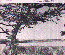
The most prominent feature of Billinge is the hill itself, locally known as "the lump", which can be readily seen from out at sea, because of the Lancashire Plain between the hill and the coast. On a clear day it is possible to see 16 counties from the top, but regularly the Welsh Hills, the Pennines, Ireland and Scotland. There is currently a small square structure on the top,erected as a sea mark in the eighteenth century. This is known as the "Billinge Beacon" and reflects the time when a beacon would have been lit on the top of the hill to warn of the coming of the Spanish Armada in 1588, one of a chain of beacons along the coast of Britain. . |
||
 |
|||
| ADMINISTRATION | |||
 |
|||
| BILLNGE HILL | |||
