|
From: Mr.
Stephen McCabe
To:JOHN STONEMAN
Sent: Tuesday, September 09, 2008 12:30 PM
Subject: Fw: South Branch of the Catt Sent: Monday, September 08, 2008 2:44 PM
Subject: South Branch of the Catt
Hi John, In-as-much as you've been helpful and proactive in the past, I'm calling on you yet again for support and a favor: could you please post the following announcement on your Zoar Valley web site? As you'll see, it's pretty much a self-explanatory attempt to announce the steps that three South Branch landowners are taking to try to stem the ever-growing tide of destruction that has been going on down there. I know you and I have discussed the problem at some length in the past and I'm not sure whether you've been down the South Branch lately, but the time has long since come and gone to try to reclaim the area. Here's the copy, in bold, that I'd ask you to post:
Landowners in the South Branch gorge of
Cattaraugus Creek are coordinating an educational and law enforcement
effort to reclaim their property from an increasingly dangerous and destructive
pattern of abuse by trespassers. The Nature Conservancy (TNC) and the Nature
Sanctuary Society of Western New York (NSSWNY) have joined other private
property owners in the gorge immediately upstream from the Zoar Valley Multiple
Use Area (MUA) to post their property against trespassing in
compliance with New York State Environmental Conservation law, Section
11-2111.
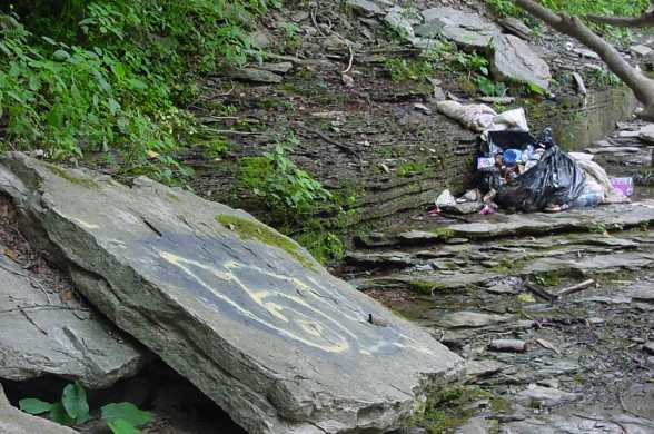
Contrary to several published guidebooks (Guide to the Ancient Forests of the Zoar Valley Canyon (Citizen's Campaign for the Environment 2001) and Secret Places: Scenic Treasures of Western New York and Southern Ontario (Kendall Hunt Publishing Co. 1994), both by Bruce Kershner, and anonymous copy posted on numerous Web sites), the South Branch gorge & upstream from the MUA has always been private property, and trespassing has neither been condoned nor welcomed there. The South Branch gorge has been the site of deaths, injuries, rescues, forest fires, alcohol and drug use, vandalism, cutting of trees, destruction and disturbance of plant and wildlife habitat, graffiti "tagging," and littering by an ever growing number of trespassers. A map of the MUA is posted in an informational kiosk at the Forty Road parking lot and can be downloaded directly as Figure 5, "Access and Parking," from the NYSDEC Web site here: http://www.dec.ny.gov/lands/22552.html. In addition, warning signs have been posted at the boundary of the MUA to inform visitors of where the border of the MUA is located. TNC and NSSWNY volunteers and private landowners have been working with NYSDEC Forest Rangers on an educational effort to advise visitors to the MUA of its boundaries. For example, during the Labor Day weekend, more than 300 MUA visitors were turned back with warnings after attempting to trespass on private land in the South Branch gorge; despite this effort and warning, more than two dozen arrests were made for trespassing in the South Branch gorge off the MUA. The New York State Environmental Conservation Police and the New York State Forest Ranger Division have clearly marked the boundary of the MUA with signs and are continuing to arrest trespassers on posted private property in the South Branch gorge. Depositions have been filed by TNC, NSSWNY, and other private landowners within the gorge, and those arrested are being prosecuted to the fullest extent of the law. TNC, NSSWNY, and private landowners feel strongly that the current educational and law enforcement effort they are undertaking is the best way to help preserve and protect this unique, fragile, and--sadly--terribly abused area. I'm also attaching some recent photographs to give just a rough idea of the scale of the abuse, although you've probably seen worse. The dead tree is one killed in an area of old growth timber during a forest fire on Mother's Day 2006. The fire was set by a drunken trespasser's runaway campfire on the plateau at the Big Falls, and it burned all the way up the gorge wall to Deer Lick. The flames girdled many trees, and they are dead or dying. The cut tree is a hemlock that was cut down with an axe by trespassers, probably because it held a posted sign. Please feel free to post any and all of these photos as you see fit; I would ask only that you include a photo credit line (Photo by Steve McCabe, Copyright 2008) so that they are not reproduced elsewhere without my permission. Also, do you think it would be worthwhile to post the NYSDEC map that I linked in my copy above? You've got the Deer Lick map posted, so maybe the actual MUA map would be equally helpful. I appreciate your consideration of this request, John, and remain hopeful you'll see fit to help. I know we agree the resource is well worth the effort. Best regards-- Stephen J. McCabe, Preserve Custodian
 (Photo by Steve McCabe, Copyright 2008)
|
Deer Lick Sanctuary
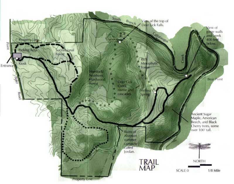
Deer Lick Map
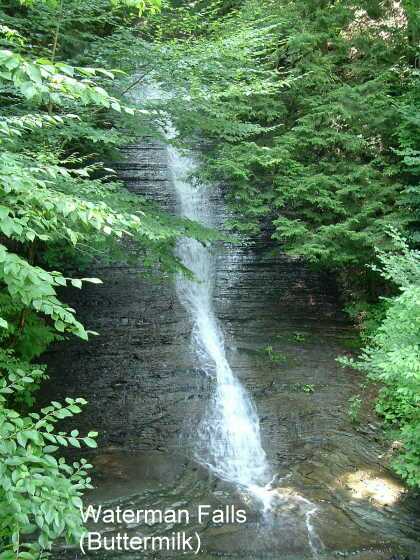
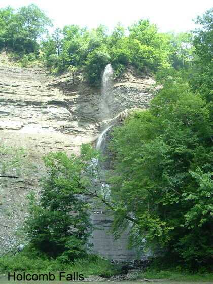
Waterfalls in the Zoar Valley area
|
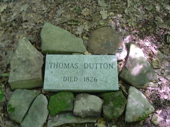
The Dutton Headstone The road into Otto via Little's
mills was cut through the breakers by Ahaz Allen in 1830. Prior to that
time there was a path from Darby flats (now Valentine's Flats) after fording the south branch
up the breakers, where pedestrians in the early settlement found their
way into East Otto and Ashford. In the fall of 1826 Thomas Dutton, a
resident of Lodi, passing this way with the view of going to Ashford,
was drowned. The next spring his remains were found among the flood
wood at the head of a small island some 100 rods below. The coroner,
Ahaz Allen, held an inquest on the body, but the remains were so badly
decomposed that it was impossible to determine whether he came to his
death by violence or by accidental drowning. When he left Lodi he had
$400 on his person and a silver watch, and as neither money nor watch
were found with him it was the prevailing opinion that he met his death
by the hand of some unknown assassin. He was buried on the upper
end of the flats near the south branch where a rude stone slab marks
the spot where his ashes repose, and where picnickers from the village
resort every year and hold high carnival.

 First photo by Chris Pearson Click to enlarge |
Knife Edge Ridge Geocache And other Geocache's in the Zoar Valley area: The Four Giants Holcomb Pond Cache A Dead Give Away A Rare Find
|