Site hosted by Angelfire.com: Build your free website today!

Uintah Valley Reservation-History: Some Facts


An Online History and Writing Journal

divider

An Old 1872 Diary; Los Pinos Agency [Picture Page] [History-Natani]

website and pages created by Norman Cambridge 1999

Summary

These are pictures and links on Ute History taken from various sources. Appropriate cites and sources are noted. Welcome and hope it tells you a little about the Ute Reservation.

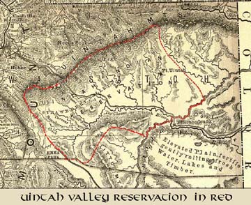
Map of the Uintah Valley Reservation created October 3, 1861, in Northeastern Utah, reservation boundary highlighted with red line, map is dated 1876. This is taken from the Northeastern corner of the Indexed Map of Utah published by Rand McNally and Company, Chicago, 1876. Scale is 1:950,000, Title from Cover, description derived from published bibliography.

REPOSITORY LIBRARY OF CONGRESS GEOGRAPHY AND MAP DIVISION WASHINGTON DC 20540-4650 USA

Cover Page Indian Service Annual Report taken from files of Uintah & Ouray Agency, portion concerning annual report for 1897

Indian Service Annual Report Pge 285, First Page of Uintah & Ouray Agency report for 1897

Indian Service Annual Report Pge 286, Second Page of Uintah & Ouray Agency report for 1897

Indian Service Annual Report Pge 287, Third Page of Uintah & Ouray Agency report for 1897

Indian Service Annual Report Pge 288, Fourth Page of Uintah & Ouray Agency report for 1897

W STARK - CARPENTER LISTED IN Indian Service Annual Report Pge 531, Agency Employees of Uintah & Ouray Agency report for 1897

W STARK - CARPENTER LISTED IN Indian Service Annual Report Pge 724 , Agency Employees of Uintah & Ouray Agency report for 1901

American Memory, Utah Map 1876.

Ft. Laramie to Salt Lake; Map of Trails & Routes

1858 Army map makers made this depiction of map of routes to Salt Lake City, Southeastern part shows trail from Wyoming along Green River to Ft. Uintah (Whiterocks, Utah) and then onto mouth of what is now Rock Creek and up over Hanna to Kamas.

Map of the Uintah and Ouray Reservation-Current

1977 Uintah and Ouray Reservation> depicting various "checkerboard ownership" of lands within the Uintah Valley Reservation created by Presidend Lincoln by Executive Order dated Octover 3, 1861, and Uncompahgre Reservation created in 1880. The peach color is Ute Indian Tribal Trust Land, the yellow represents land under BLM, the blue color is Utah State owned lands, the white color represents Cash Entry lands owned in private status. In 1985 the 10th Circuit Court in Denver held in the Utah vs. Ute Tribe case held the original reservation boundaries of the Uintah Valley and Uncompahgre were never diminished which creates a complicated jurisdiction in civil and criminal matters within the reservation boundaries which affect water, water ways, rights-of-way civil and criminal matters. This map is taken from the files of the Uintah & Ouray Agency of the Bureau of Indian Affairs, Department of the Interior, Fort Duchesne, Utah.