
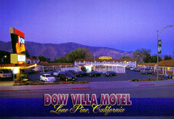
Mt Whitney 14,497 FEET Mt. Whitney Trail Last year while driving up the I-395 up towards the High Sierras I stopped at the Interagency Visitors Center just outside of Lone Pine, California. Across the road and off in the far distance stood the high crest of the Eastern Sierras separating the harsh dry desert of the Mojave Desert from the tall redwoods of the Sequoia National Forest. Here at it's crest standing guard was the pointy peaks and striated cliffs of the Mt Whitney Range of mountains, which include Mt. Muir, Mt. Langley and Mt. Russell, all of which are over 14,000 feet tall. I vowed that next year I would return and scale the tallest of those peaks and stand proudly on top of the United States. Surmounting such a lofty goal requires preparation and dedication. Beginning in early February climbers and hikers sit beside their TV drifting into daydreams of standing atop of frosty peaks. Endorphins flowing through their physically spent bodies they feel the warm flushness of blood flowing into their cold cheeks while the brisk air chills them to the bone. This is the season of those contemplating the long arduous 10.7 mile climb up 6,000 feet to the top of Mt. Whitney. Due to it's relative proximity of major metropolitan cities such as, Los Angeles, San Francisco and Las Vegas, it one of the most highly traveled hiking trails in the country. The Inyo National Forest issued 19,980 permits for this trail in 2000 and an annual drawing is held in February for those lucky ones who draw the coveted permits. Preparation for such an undertaking requires time, equipment and money. I estimated it would take six months to accumulate enough vacation time from work, buy necessary equipment and save up enough money for the expedition. September 21, 2001 was selected for the forced rapid ascent, after Labor Day to avoid crowds and the oppressive heat of the Mojave Desert summer. While temps at the summit would be in the thirties, temps at the base of the mountain and in Lone Pine would be hovering around the mid 90's. I had been purchasing gear for over two years, little by little, fueled by a desire to escape into the wilderness, anywhere, as long as it was wilderness. Funds were collected and savored from EBay sales, extra hours worked providing security for Traffic School in the courthouse and birthday monies stashed and coveted until the REI Sales flyers were anxiously received in the mail. Dedication is defined as being wholly committed to a cause. Our cause was to climb not only the highest point in the contiguous United States, but to do it in one day. Our plan was to start from the Whitney Portal Trailhead in the dark at 3:00 A.M. and using headlamps hike up to Trail Camp by dawn. We'd take our time climbing up the ninty-seven switchbacks and reach Trail Crest around 10:00 A.M. Here we would take another break before tackling the last four miles reaching the summit around noon. The return trip would get us back to the car before dark at 6:00 P.M. Based on our experiences with altitude sickness at lower elevations I figured I would would need some acclimitizing before the hike. We selected Horshoe Meadows Camp as a last minute change of plans. I remembered Troy and I already had the week off from work and Dave was scheduled off that day anyway. I also figured we would need a short dayhike from the portal up to Lone Pine Lake the day before to familiarize ourselves with the trail that we would be hiking in the dark the next morning. Reservations were made way in advance at the Dow Villa Motel in Lone Pine and our itenerary was set. We would leave Wednesday September 19th and stay at the Horseshoe Meadows Recreation Area, camping out at 10,000 feet to acclimate. Thursday September 20th we would check into the Dow Villa and go on a short dayhike to Lone Pine Lake, returning to the motel room to sort our gear before the big event in the morning. We would eat a big carb filled pasta dinner at The Pizza Factory in Lone Pine and hit the sack early. On Friday morning at 2:00A.M. we would wake up and head up to the portal and begin our marathon hike, returning to the Dow to soak in the jacuzzi. Wednesday September 19, 2001
We headed up the East I-15 freeway through the Cajon Pass and turned Northbound on I-395. The road towards Adelanto is a well paved four lane highway and if filled with big trucks, campers, motorhomes and beaten up dust filled mid 1970's cars. We passed several worn out old strip bars and side of the road cafe's and eventually we came to High Desert Maverick's Baseball Stadium, Single "A" affiliate of the Oakland A's Baseball Team. At 10:30am we pulled up to the Kramer Jct/Four Corners intersection with Hwy 58. Roadside peddlers of Persian Rugs, ceramic dog statues and miscellaneous knick-knacks adorned the dry parched shoulders of the road. Truckers coming from al directions were pulling into the diners and gas stations to refill their rigs and bellies.
Quickly back at highway speeds we passed the Olancha Post Office and could see the massive rugged peaks off to our left growing in size. Within minutes we saw the sign for the Inter-Agency Visitor's Center, signaling our arrival in Lone Pine.
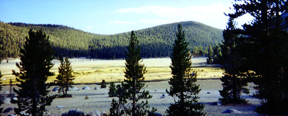
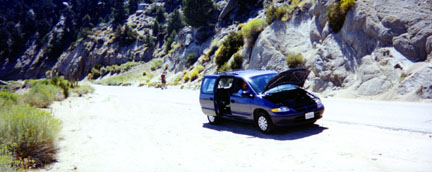
After buying a plastic covered trail map we hit the road and intered Lone Pine. We stopped at P.J.'s Restaurant and had lunch before heading up the Whitney Portal Road to the Horseshoe Meadows Road turnoff looping back southward. The road to Horseshoe Meadows climbs steadily up a steep series of switchbacks and my van overheated about 3/4 of the way up. We eventually arrived at the top of the pass and dropped down into the Meadows area. We drove around through the campground loops for the Cottonwood Lakes and Equestrian Camps before settling on the the Hiker Walk-In Camp at the 10,000 foot level. We dragged our gear to a shared picnic table and staked out our tent sites.
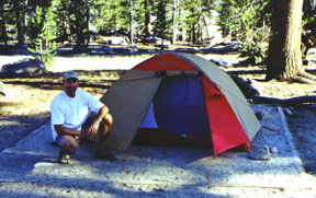
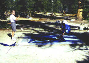
Troy and Dave set up Dave's Kelty Campsite Four Tent while I staked out my Eureka Mountain Pass 2XT tent. I was in the process of chopping up the firewood Dave bought at Lee's Frontier Liquor and Chevron in Lone Pine when another camper approached our bear locker. He was carrying a large ice chest and I thought he was going to fill it up. I told him there were other lockers over to the side but he insisted in using ours. There was room for everyone he told us after a few intense seconds when I stood up with my axe in hand. We cooked hotdogs and toasted the buns over the fire grate and settled down to a chilly 30 degree night. The sky was crystal clear and the Milky Way was visible across the sky. Other than being anoyed by late arriving discourteous campers and having to pee four times, we all slept soundly.
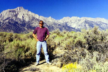
Thursday September 20, 2001 Sunrise comes early in the mountains and we packed up the camp and headed back to Lone Pine. Along the way we stopped at the Alabama Hills and took a few photos of Mt Whitney in the distance.
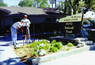
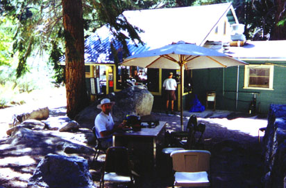
We arrived at the Dow Villa and checked into room #41 after confusing the desk clerk about how to break up the bill. We cleaned up and I headed off to find some souvenieers for my kids while Dave tried to get a haircut. We threw together some gear and headed up to the Whitney Portal for lunch and to scout out the trail after picking up our Whitney permits at the Lone Pine Ranger Station and checking out the peaks through the tubes out front.
We reached the portal after standing beside the side of the steep portal road waiting for the van to cool down again. Dave bought a hamburger while I ate a fried hot dog. Troy fed the bluejays while Dave dodged the yellow jackets feasting on him under the umbrella above the Whitney Portal Store.
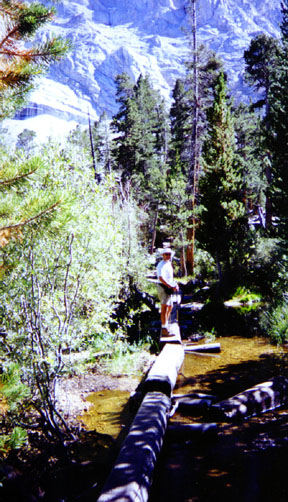
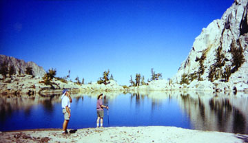
We started up the well marked Whitney Trail and made the log crossing before hiking down to Lone Pine Lake. The 2.5 mile hike gains 1500 feet and travels through chaparral and sage before reaching the tall pines of Lone Pine Lake. Here we took a brief break and admired the mirror reflections of the lake before heading back to the portal.
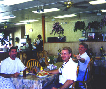
We drove back to the Dow Villa and dropped off our gear. We went to the Pizza Factory and filled up on high carbohydrate spaghetti while Dave ordered a pineapple pizza. Troy and I headed back to the Dow while Dave finished eating. We all sorted our gear one last time and laid out our clothing for a fast take off in the morning. I called the desk clerk and asked for a wakeup call at 2:00 A.M. Friday September 21, 2001
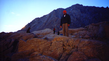
3:00A.M. We started hiking three hours before daylight and used our headlamps to light up the trail. They worked surprisingly well and we didn't have any trouble finding our way in the dark. We came upon the log crossing and Lone Pine Lake at 4:20 A.M. Stopping for a short break I ate some cold Poptarts and we started up towards Outpost Camp. The trail switchbacks around the side of a mountain then crosses a swampy area before entering the camp at 5:00A.M.. We could see the multicolored dome tents reflecting off our headlamps just off the trail. We passed the outhouse and headed up toward Mirror Lake. The trail is well marked most of the way but as we came upon a section of large boulders the trail disappeared into the darkness. We stumbled upon another hiker standing just off the trail. His headlamp was inoperable and he followed Troy using his ambient light. We must have passed Mirror Lake in the dark and before we knew it daylight was near.
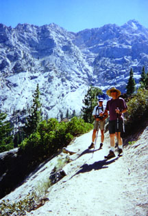
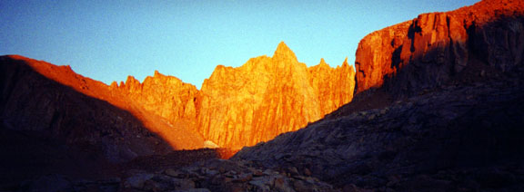
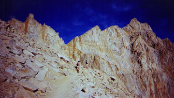
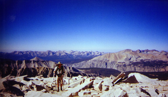
I started up the dreaded 97 switchbacks ahead of Troy and Dave. The sun was rising over Lone Pine and the view of Constelation Lake was beautiful. The peaks ahead reflected the sunrise and cast a warm enticing glow over the Whitney range.
Troy set the pace as I followed with Dave bringing up the rear. The switchbacks were not as steep as I imagined but seemed to go on forever. We reached the cables as we broke out of the shade and into the intense sun. The fleece came off and we hiked up to trailcrest in shorts and T-shirts.
Just past the cables I began to feet the altitude sickness affecting me so I took another Diamox. Dave was having trouble keeping up and had to slow down. He did not take anything for AMS and was beginning to pay the price. He figured out on his own that if he slowed down he could manage without Diamox. I took some TUMS for nausea but otherwise felt pretty good. Troy was having no effects of the altitude and was going strong.
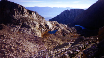
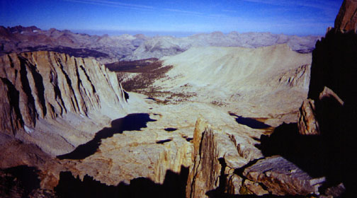
At 8:50 A.M. we traversed the last switchback and leveled off at TrailCrest. The view over the other side to Sequoia National Forest was magnificent. The wind picked up to about 15 mph and we almost lost our hats. Quite a few people were taking a break at the crest and flat resting places were at a premium. We hiked further down and found a large slab rock overlooking a huge dropoff and took some photos.
We knew we would make the summit now and we were feeling stronger. We continued to the left of the peaks visible from Trail Camp and had great views down below of Mt.Hitchcock and Guitar lake.
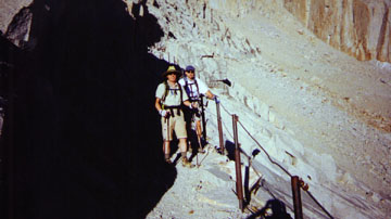
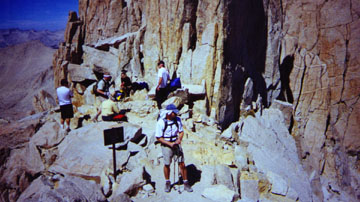
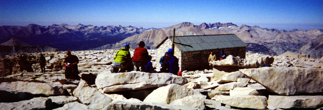
We entered a section where we could see through the slits in the rock toward the Lone Pine side of the mountain. These small spaces are called the "Windows" and wind blasted through the gaps. The drops below the windows were over 1000 feet and made you feel nervous while standing in them. After passing the third window the trail becomes difficult to follow. Ducks mark the trail as people have placed small piles of rocks, stacked on top of one another, alongside where you are to go. People can now be seen on top the summit peering over the edge and the views west are incredible. We turned up to the right and made the final approach to the summit.
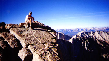
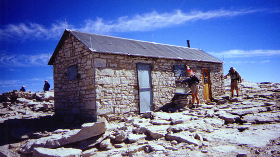
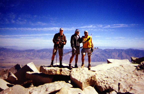
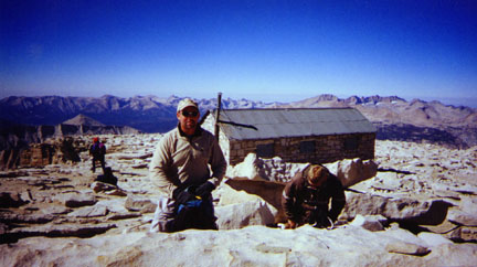
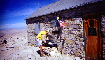
I let Troy and Dave go up ahead and sign in to the summit hut register while I snapped some photos. It was only 10:30A.M. and we had made the summit in only seven and one half hours.
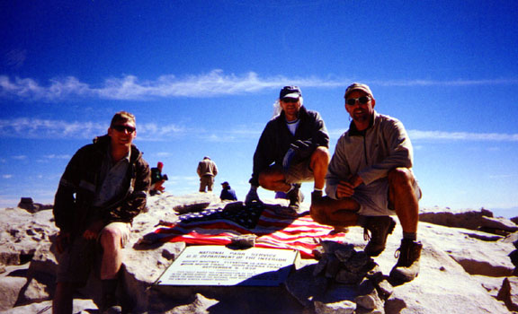
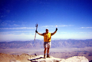
We all gathered and walked up to the sumit marker together. An American flag had been placed above the marker in memorial to the victims killed in the terrorists attacks in NewYork City and Washington D.C. We posed for a few photos as I removed a small American Flag from my backpack and stood atop the highest rock.
People were milling around the summit calling come and celebrating while others slept. I used my Ham radio and made an autopatch phone call home to my wife but she was not home. We all felt great and most of the nausea and headaches went away. It was great to be on top.
The uphill section was steeper than I remembered but we climbed up quickly. We came upon Trailcrest and stopped for only a few moments. We were glad to be heading down the switchbacks and now we were able to enjoy the view.
At 3:25 P.M. we passed Outpost camp and stopped for a brief rest at the junction to Lone Pine Lake. I rushed everyone along and we made the last 2.5 miles in only an hour. At 5:00P.M. we took the last few steps and congratulated eachother at the Whitney Trail Sign, where only 14 hours ago we had begun the climb. We tossed everything into the van and headed back down the portal for a well deserved shower and meal. We went to the Mt.Whitney Restaurant but had to get up and leave without ordering because the service was so terrible. We sat at a table for 15 minutes without even getting the attention of the only waitress on duty. We decided to head back to P.J.s where I had a huge Chili-size burger and a beer. Troy ate a Reuben Sandwich while Dave custom ordered a teriaki chicken sandwich. With full bellies we headed back to the Dow for a dip in the jacuzzi. The warm bubbling water felt great on our aching muscles and contributed to our quick recovery. We all went to bed early and fell asleep due to sheer exhaustion. The next morning we hit P.J.'s again then hit the road home. We stopped
by the Visitor's Center for Troy to buy a poster then headed home. We cruised
through the desert and arrived at Walt's house just about 1:00 P.M. We unloaded our
gear and said goodbye to eachother and headed home.> |

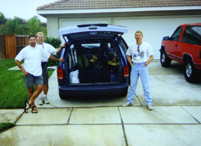 At 9:00A.M. I
pulled up into a co-workers driveway in Corona, Ca. and met Troy and Dave who had driven
separately. We had agreed to rendevous at Maxwell's house since it was centrally
located and near the freeway. We loaded up our gear in my Dodge Caravan and headed
up the I-15 Fwy. We turned northward onto the I-395 and headed up towards Lone
Pine.
At 9:00A.M. I
pulled up into a co-workers driveway in Corona, Ca. and met Troy and Dave who had driven
separately. We had agreed to rendevous at Maxwell's house since it was centrally
located and near the freeway. We loaded up our gear in my Dodge Caravan and headed
up the I-15 Fwy. We turned northward onto the I-395 and headed up towards Lone
Pine. 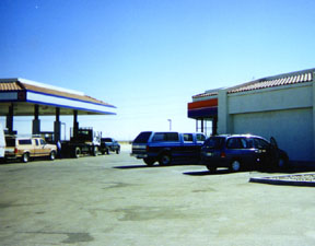 We
had to pee so we went to the AM/PM to take advantage of their not-so-clean
restrooms. We filled up our drinks and took turns using the crowded restrooms.
This junction attracts all different kinds of people and tourists travelling through the
desert. Most people stop here as there ia no other gas stations for many miles.
We
had to pee so we went to the AM/PM to take advantage of their not-so-clean
restrooms. We filled up our drinks and took turns using the crowded restrooms.
This junction attracts all different kinds of people and tourists travelling through the
desert. Most people stop here as there ia no other gas stations for many miles.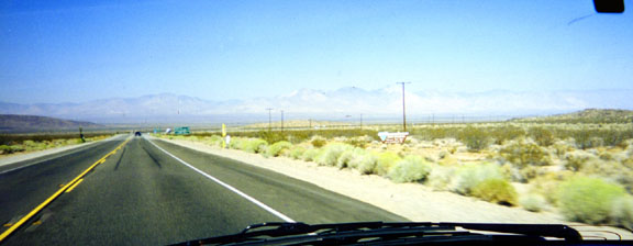 The
road from Kramer Junction is well paved but none scenic. Mile after mile of Mojave
Desert seemed to crawl by even at freeway speeds. Traffic was light this Wednesday
so we sailed up through Red Mountain, China Lake Naval Weapons Center and passed the huge
field of solar panels on the left side of the road. Red Mountain looks
like what the desert is supposed to look like. Old dilapidated shanties, boarded up
Esso Gasoline Stations and rusty junk cars piled up high on the lawns of the less
fortunate dwellers of the desert.
The
road from Kramer Junction is well paved but none scenic. Mile after mile of Mojave
Desert seemed to crawl by even at freeway speeds. Traffic was light this Wednesday
so we sailed up through Red Mountain, China Lake Naval Weapons Center and passed the huge
field of solar panels on the left side of the road. Red Mountain looks
like what the desert is supposed to look like. Old dilapidated shanties, boarded up
Esso Gasoline Stations and rusty junk cars piled up high on the lawns of the less
fortunate dwellers of the desert. 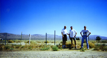 Coso Junction's rest
stop and cool shady trees lured us off the highway where we stopped for a
brief break at 11:45am.
Coso Junction's rest
stop and cool shady trees lured us off the highway where we stopped for a
brief break at 11:45am.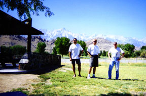


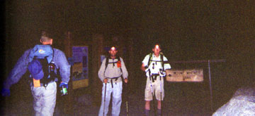 2:00A.M. came
rudly and we drove up to the portal in the crisp morning air. We turned on our
headlamps and started up the trail after being startled by a hiker in sleeping bag lying
beside the bear lockers in the dark. I set the self timer on my camera but Troy
didn't hear me in time.
2:00A.M. came
rudly and we drove up to the portal in the crisp morning air. We turned on our
headlamps and started up the trail after being startled by a hiker in sleeping bag lying
beside the bear lockers in the dark. I set the self timer on my camera but Troy
didn't hear me in time.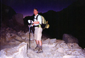 The sun began to soften the
darkness and the horizon below turned from dark black to purple into blue. Troy hid
his headlamp in some boulders marking the spot with a rock cairn. Just up ahead we
could see the terrace above and see the sunlight reflecting off the solar outhouse.
We passed the smelly restroom and entered Trail Camp. People were just waking up and
stood in groups talking. This would be our longest break before the switchbacks so
we dropped our packs. I ate a power bar while Troy tried to eat a bagel. It
was only 30 degrees with a brisk wind. Everyone was chilled so we donned fleece
jackets and beanies.
The sun began to soften the
darkness and the horizon below turned from dark black to purple into blue. Troy hid
his headlamp in some boulders marking the spot with a rock cairn. Just up ahead we
could see the terrace above and see the sunlight reflecting off the solar outhouse.
We passed the smelly restroom and entered Trail Camp. People were just waking up and
stood in groups talking. This would be our longest break before the switchbacks so
we dropped our packs. I ate a power bar while Troy tried to eat a bagel. It
was only 30 degrees with a brisk wind. Everyone was chilled so we donned fleece
jackets and beanies.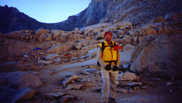
 At 11:15A.M. we started back
down. Wanting to make it back to the van before dark we took one last look around
and headed down I stopped by the summit hut and signed in before following Troy and
Dave down the ridge towards the trail. I gave words of encouragement to those
nearing the top and my legs appreciated going downhill for a change. We passed the
Windows quickly and came to the only uphill section on the return hike. The trail
from Trailcrest to the John Muir Trail loses 500 feet on the way up and now it was time to
repay the favor.
At 11:15A.M. we started back
down. Wanting to make it back to the van before dark we took one last look around
and headed down I stopped by the summit hut and signed in before following Troy and
Dave down the ridge towards the trail. I gave words of encouragement to those
nearing the top and my legs appreciated going downhill for a change. We passed the
Windows quickly and came to the only uphill section on the return hike. The trail
from Trailcrest to the John Muir Trail loses 500 feet on the way up and now it was time to
repay the favor. On the way down the
switchbacks we passed an elderly man hiking without a pack. He told us he wasn't going to
make it and was going to turn around. I offered him a Diamox but he said he didn not
have altitude sickness and that he was just getting too old. Partway down the switchbacks
we discovered his pack stashed near the rocks. We crossed the cables jabbing the ice
with the tips of our trekking poles and eventually returned to TrailCamp.
On the way down the
switchbacks we passed an elderly man hiking without a pack. He told us he wasn't going to
make it and was going to turn around. I offered him a Diamox but he said he didn not
have altitude sickness and that he was just getting too old. Partway down the switchbacks
we discovered his pack stashed near the rocks. We crossed the cables jabbing the ice
with the tips of our trekking poles and eventually returned to TrailCamp.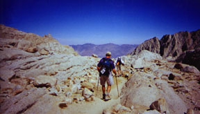 We did not stop
at trail camp and continued on through the boulders above the solar outhouse. We
stopped birefly for Troy to recover his headlamp while I spoke to a friendly hiker from
San Diego. He told me he had climbed Mt.Whitney for the eleventh consecutive year
and started up the trail at midnight. I congratulated him and passed him on the left
as he was moving slowly.
We did not stop
at trail camp and continued on through the boulders above the solar outhouse. We
stopped birefly for Troy to recover his headlamp while I spoke to a friendly hiker from
San Diego. He told me he had climbed Mt.Whitney for the eleventh consecutive year
and started up the trail at midnight. I congratulated him and passed him on the left
as he was moving slowly. We passed the
boulders where we lost the trail and saw beautiful Mirror Lake off to our left. I
couldn't see how we had missed it on the way up. Troy took a few photos and we
continued down using large flat rocks as stepping stones. Troy's knees were starting
to bother him and Dave was slowing down. My headache was starting to go away and I
was getting anxious to get back to the van. We still had a few hours to go and I was
starting to get tired.
We passed the
boulders where we lost the trail and saw beautiful Mirror Lake off to our left. I
couldn't see how we had missed it on the way up. Troy took a few photos and we
continued down using large flat rocks as stepping stones. Troy's knees were starting
to bother him and Dave was slowing down. My headache was starting to go away and I
was getting anxious to get back to the van. We still had a few hours to go and I was
starting to get tired.