FROM BAY PATH TO BACK BAY: A GUIDE TO THE BOSTON MARATHON COURSE
By John A. Quatrale
NOTE: For a written copy of this guide with footnotes and sources please e-mail the author at info@bostonmarathoncourse.com. This electronic version is updated on a regular basis.
INTRODUCTION
For over 100 years, the Boston Athletic Association (B.A.A) Boston Marathon has annually made its way from the western Boston suburbs into the City of Boston. This 26.2 mile road race, now with nearly twenty thousand qualified runners, started very small in 1897. But over the years the race has grown to become an important athletic and historical event. As an athletic event, the race, the longest continuously run marathon in the United States, is recongized as one of the premier races in the world. As an historical event, the race helps celebrate the start of the American Revolutionary War. Of equal importance, this event celebrates the history and the connections among eight communities. In many ways the historic route tells the story of the founding, the development and the people of diverse but interconnected towns over the past 400 years. The winding roadway, once a dirt pathway, is now a means to view and learn about the history of Massachusetts and New England. The race course has become an historic venue in its own right while at the same time celebrating the historic significance of the made-made and natural environment. Since 1989, a fall Jimmy Fund Marathon Walk has also taken place along the same Patriot's Day running course every September. That fundraising event now attracts several thousand participants as well.
So, for everyone that has or will run this historic marathon and for the millions that will continue to line the streets to cheer, here's a profile of the meaningful things to see and know about this important marathon trail. This guide is written for everyone that enjoys knowing about the sights around around them. Runners, walkers and non-runners will find it a source of information that will answer many of the questions that arise. It will hopefully prompt many to ask more questions about what they see along he course and to seek our even more information. The guide can be used on parts of the course or the entire course. Marathon runners should be able to identify sites and points of interest as they go about their training runs. Some runners may even find it useful during the marathon. Non-runners may choose to take an automobile, bus or bicycle trip over all or part of the course. Walkers can also make use of the information as they go out on their walks. It is hoped that this guide will encourage everyone to get out and explore this fascinating and historic trail. It will quickly be discovered that with this new knowledge the marathon route will be viewed as much more than just a static place that comes alive one day a year. The history of the development of this dynamic and ever-changing route begins with Native Americans in the 17th century and continues with the construction of skyscrapers in the 20th century. In between, trails and highways were laid out, towns were born around factories, railroad lines were built, grand commercial and residential buildings were erected, a great waterway was filled, immigrants settled, places of worship were organized, and great universities were opened. The story of this marathon course is further enhanced by the significant achievements of numerous men and women that are related to the history of the United States, Massachusetts and New England.
THE START - HOPKINTON

The course has started in Hopkinton in Middlesex County since 1924, when it was lengthened to the officially recongized marathon distance of 26.2 miles. The original town name of "Hopkinstown" was in honor of Edward Hopkins, a colonial governor of Connecticut. The ogininal settlers of 1715 from surrounding villages leased their land from Harvard College, which was the executor of the Hopkins estate. Although today's visitors may presume that Hopkinton has always been a quaint rural town, the town's greatest development was due to shoe manufacturing in the 19th century. Until the early 20th century, Hopkinton was a leader in that field.
Since 1924 the starting line has been on West Main Street in the center of town. The course traverses down the old Bay Path, a Native American trail that connected Cambridge to Connecticut in the 17th century. The Bay Path was also referred to as the Old Connecticut Path by the early settlers of the 1630's in the Framingham area. An historic plaque for the "Bay Path" is located in front of the Town Hall. The current West Main Street, also known as State Route 135, is filled with numerous historic and architecturally significant 18th and 19th century buildings and adjacent to the marvelously preserved Hopkinton Town Common. In 1882, a major fire destroyed much of the business district as well as the First Congregational Church building. The present white church building facing the common was built in 1883 and is now occupied by the Community Covenant Church. Adjacent to the common near the starting line is a section of roadway that the town has renamed "Marathon Path".
A building of particular note is the small freestanding building at 26-28 East Main Street, which is listed in the National Register of Historic Places as an excellent example of "mail order" commercial architecture. All National Register of Historic Places designations are made by the U.S. Department of the Interior. Nationwide there are approximately 70,000 buildings in that National Register.
Another noteworthy building is the Old Stone Tavern, which overlooks the Common and the World War I statue. In this building, George Washington, Marquis de Lafayette and Daniel Webster all probably lodged. It was built the same year as the Baury House in Newton Lower Falls. Both buildings were built in 1750 and are the oldest remaining structures along the marathon trail.
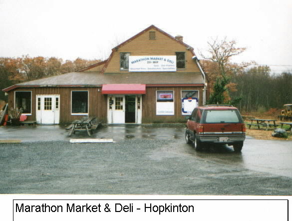
At the beginning of the course, after the first downhill, is the new First Congregational Church building which was erected in 1997. A short ways after the church on the left is the Weston Nursuries, one of the oldest and largest horticultural centers in New England. A short ways after the nursery is the Marathon Market & Deli on the left. This is the only business along the course that references the marathon in its name.


ASHLAND - MILE 1.9
The "Bay Path" route continues along Route 135 into the Town of Ashland. The original name of the town was the Village of Magunkaquog, a name established by Natick Indians about 1659. The town later became known as Unionville after the Boston & Worcester Railroad company opened a passenger station to serve Ashland's growing industrial base. The town name was eventually changed to Ashland in 1846. "Ashland" came from the name of Henry Clay's (unsuccessful presidential candidate of 1844)plantation in Lexington,Kentucky.Clay's former home is now a National Historic Landmark and museum. The marathon route, today known as West Union Street and Union Street, continues past the Ashland State Forest, which is on the right after entering Ashland. This Massachusetts state park includes a swimming beach at the Ashland Reservoir. After crossing the Main Street intersection, the Ashland Technology Clock is at mile 4.0 at the intersection of Union and Chestnut Streets. This tower is a noteworthy local landmark. On the left the Sudbury River comes into view all the way into Framingham.
Until 1924, the marathon route commenced at various starting points in Ashland. The last such start point was at Steve's Corner, where Route 35 (West Main Street) intersects with Oliver Street and Frankland Road.
FRAMINGHAM - MILE 5.0
The "Bay Path" trail then moves into the Cobornville section of Framingham and then into the main sections of Framingham. Framingham was settled in 1660, when it was charted as "Mr. Danforth's Farms". Mr.Thomas Danforth changed the name to Framingham after the English Town of Framlingham where he was born. The "L" in Framlingham was dropped when the Massachusetts town was formally chartered in 1700.
Framingham's industrial past is far more evident than that of Hopkinton or Ashland. The town harnessed the water from the Sudbury River for this industrial development until the river was deflected in 1872 as a source of water supply for the City of Boston. This is evident as the course proceeds on Waverly Street past the Dennison Paper Manufacturing building complex on the left beyond the railroad lines. This is followed at mile 6.2 (10 kilometers) by the prominent Henry Hobbs Richardson designed train station (1885) in the Romanesque architectural style. Richardson received his greatest acclaim for his design of the Trinity Church in Boston's Copley Square. Although the historic train station is now used as a restaurant, an adjacent smaller modern station is still a stop on the train route from Boston to Worcester. From the train station to just past the Natick line, the course takes a destinctive automobile appearance. During this stretch, there are several auto dealers, used auto lots, gasoline stations and automobile parts stores.

The Town's commercial preeminence is also demonstrated by several outstanding 19th-early 20th century buildings along Route 135. These buildings include those in the Irving Square Historic District such as the Bullard Building (1906) at 410 Waverly Street and the adjacent 390-398 Waverly Street buildings (1910). The entire district which stretches southward from Rt. 135 is listed in the National Register of Historic Places due to its importance to the development of Framingham after the railroad arrived in 1834. A toll road, known as the Central Turnpike, passed through Framingham from 1830-1836 on the current Rt. 135 all the way through to Hopkinton. This private road failed after only six years in business when the Boston and Worcester Railroad Company started its operations. The businesses in the area preferred this new railroad, which was better positioned to serve their business needs than the toll road.

NATICK - MILE 7.5
The "Bay Path", with the current Boston and Albany Railroad lines continuing to run parallel, resumes into the Town of Natick. This town was established in 1651 by the Puritan missionary and pastor of the Roxbury Church, Rev. John Eliot. Natick, a "Place of Hills" was the first of the 30 "Praying Indian" settlements established by Rev. Eliot. All of his settlements were essentially attempts to convert and "civilize" the Indians. Rev. Eliot's efforts resulted in Natick's Algonquin Indians building a meeting house and farming the land. An Indian named "Waban" was appointed justice of the peace to oversee the civil affairs of the Indian village. But King Philip's War (1676-1678), led by the Indian King Philip, led to the banishment of the Natick Indians to Deer Island in Boston Harbor. Following the war and Rev. Eliot's death in 1690, the Natick Indians struggled to maintain their Indian Plantation. By 1725, most of the Indians had sold their Natick land. The last Indian family remained in Natick until about 1792. A portion of the Indian Reservation or plantation remained until 1861. However, Natick was very much considered an "Indian Town" from 1651-1762, when Natick was also predominately a farming community.
Natick's industrial emergence coincided with the introduction of the railroad in 1836. The railroad also complemented the use of the Charles River water supply for power. The primary early industries were shoemaking. The 19th century prosperity is very much in evidence as one enters Natick on the West Central Street which turns into East Central Street (Rt. 135).
The Henry Wilson Historic District, a local historic district, centered along West Central Street, has approximately 60 outstanding Victorian residences that are well preserved today. The wide variety of late 19th century architectural styles with strong exterior restrictions include Queen Anne Revivals, Stick, Shingle, Mansard, Italian Villa, Second Empire, and Gothic Rvival. One of the most ornate in this district is a Second Empire building at 72 Forest Street, on the corner of West Central (Rt. 135). 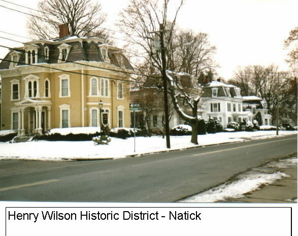 Also included in the district is the Henry Wilson Shoe Shop, the small early 19th century cobbler shop used by the 20th Vice-President of the United States. Henry Wilson, who served as Vice-President in President Ulysses S. Grant's second term (1873-1875), was a U.S. Senator from 1855-1873. Wilson moved to Natick at a young age and remained there until his death during his tenure as Vice-President. His shop, listed in the National Register of Historic Places, has been restored to its original early 19th century condition and moved to its present location at 181 West Central Street.

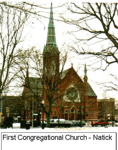
As one proceeds along Rt. 135 at mile 9.3 (15 kilometers), one passes Lake Cochituate on the left and the Fisk Pond on the right. "Cochituate" is an Indian name meaning "long pond". Natick Center is then traversed by Route 135 and Route 27. This center, listed in the National Register of Historic Places, has numerous high-style Victorian examples that were built after most of the earlier buildings were destroyed by a major fire in 1874. This present day town center is recognized as a particularly cohesive town center that demonstrates town and architectural history. Some of the individual buildings include the town's library building - Morse Institute (1875) in the High Victorian Gothic style, the Casey Block (1874) in the Italianate style, and the First Congregational Church (1875) in the High Victorian style. The latter is an exemplary example with a large circular stain-glass window and an ornate colummned spire. It is also the 7th Natick Meetinghouse, starting with the first one built by John Eliot.
 At mile 10, the Natick Town Common, across from the Church, is a well preserved and large meeting space. It has an especially well-maintained and large Civil War monument.
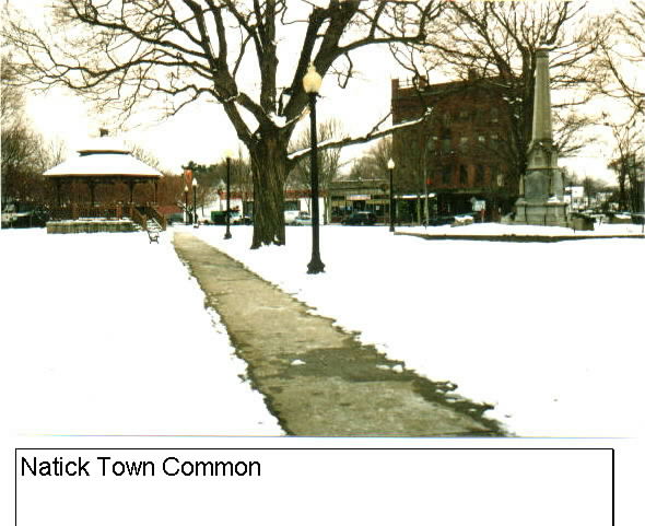 Just beyond the historic district on the left is the St. Patrick's Roman Catholic Church, a massive brick structure built in 1892. This parish, with an impressive statue of St. Patrick in the front of the church, was founded by Irish-Americans that came to Framingham in large numbers and worked in the factories.
WELLESLEY - MILE 11.8
After leaving Natick on the "Bay Path" on Route 135, one leaves Middlesex County and enters Norfolk County and the Town of Wellesley. The original name for the area that became Wellesley was "Contentment". The area was purchased from the Indians in the 1630's and was originally part of Needham. In 1774, the area became a "west parish" of Natick and in 1778 it became the separate incorporated Town of West Needham. Finally, in 1881, the town reincorporated as the Town of Wellesley. The name was chosen as a tribute to one of the early settlers of the town. In 1763, Samual Welles set-up his homestead in Wellesley. The Welles House was at the corner of Washington Street and Central Street (Route 135). In 1881, his descendent Horatio Hollis Hunnewell bought all of the original homestead and then donated the entire estate to the new Town of Wellesley.
The course in Wellesley follows Central Street (Rt. 135) and coincides with the Old Central Turnpike. At mile 12.3, the first and most prominent landmark is Wellesley College , which is located on the right. This prominent college for women is known today by every Boston Marathon runner as the area with the loudest and most heartwarming cheers and screams. Many runners in fact refer to the Wellesley College experience as a "real rush" of energy. The college was founded in 1870 as a female seminary and the name was actually chosen before the town name was determined a decade later. This institution has approximately 500 acres in the center of Wellesley. It's gothic and modern structures spread across the rolling campus hills and around Lake Waban. The lake was named in the 1860's for the Natick Indian that helped Rev. John Eliot. Waban was originally a Concord Indian that died in 1674 at the age of 70. Lake Waban was previously known as Saw Mill Pond, which was related to the area's former use. The center piece of the campus is the Houghton Memorial Chapel, a gothic revival edifice built in the 1890's. Also of note is the Durant House (the President's House), an early Victorian mansion built around 1860.
Following the college, Central Street leads into Wellesley Center where Rt. 135 intersects with Route 16. This is the half way point of the marathon (13.1). The Center, a thriving business district with numerous small specialty stores, was mostly built up in the 20th century. The dominant brick Colonial Revival Wellesley Congregational Church (1922) is also on the right. This congregation was founded in 1798. Across the street from this church is a small park that is dedicated to Katherine Lee Bates (1871-1929). This Wellesley College graduate and resident of Wellesley in her later years wrote the song: "America the Beautiful".
As one proceeds through the Center, the trail leaves the "Bay Path" and proceeds onto Washington St. (Rt. 16). On the left is the main Town Libary and the magnificant Wellesley Town Hall, perched on the hill in the middle of Hunnewell Park. At the base of this park is a Vietnam War Memorial. The town hall was originally built as a library in 1881 with a 1883 town-hall addition. This magnificant Romanesquese Richardsonian Revival masonry building, has two distinctive turrets to give the building a castle-like appearance. The surrounding park was designed by Frederick Law Olmsted, the designer of the U.S. Capitol grounds, the Emerald Necklance in Boston, and New York's Central Park. The entire Town Hall site, as well as the adjacent town libary site (1894), is located in the National Register of Historic Places. Across the street from the Town Hall is the new Wellesley Free Library. This beautiful modern brick structure opened on June 1, 2003 and is now the newest public building on the Marathon course. Washington Street (Route 16) then follows the route of the railroad lines into Wellesley Hills.

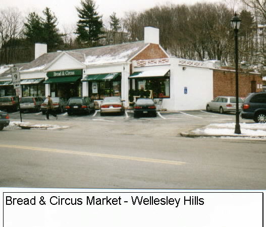
As one enters Wellesley Hills, there is the Isaac Sprague (1860-1934) Memorial Clock Tower, which was constructed to resemble the famous Venetian Campanile in Venice,Italy, is within the Wellesley Hills Common. The tower was presented to Wellesley Hills to honor a local resident when Wellesley Hills was still known as Grantville. Wellesley Hills was established as Grantville in 1851 after Moses Grant donated the bell for the Congregational Church.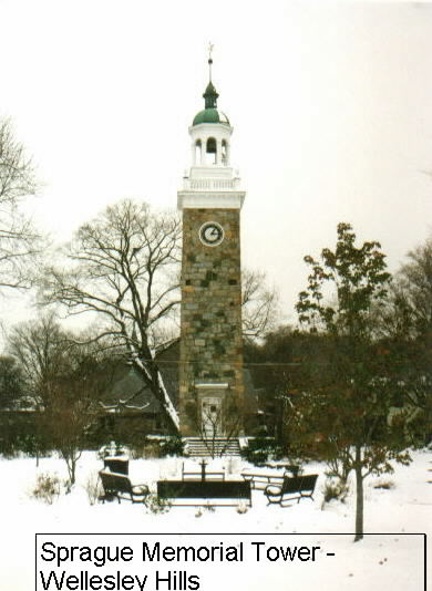 In the center of Wellesley Hills, one passes over the Route 9 bridge, which was the original Boston-Worcester Turnpike. This Rt. 9 underpass and bridge was built in 1932. Immediately following Rt.9 and set back a little to the left is the Dadmun-MacNamara House (1824). This house was originally the toll-keeper's house for the turnpike and now houses the Wellesley Historical Society museum and offices. The Wellesley Hills Congregational Church follows on the left. This congregation was organized in 1847 and the current building was built in 1901. The Wellesley Hills business district includes the Whole Foods Market (formerly the Bread and Circus market), which is the largest national chain of natural, organic and whole foods.

 Proceeding on down Washington Street, one begins a descent down Maugus Hill, a 300 foot elevation hill named for one of the original Wellesley Indian Chiefs that was converted by John Eliot. On both sides of Maugus Hill there are numerous architecturally prominent Victorian residences. Near the base of the hill to the left (at the end of Glen Street) is the area known as Wellesley Farms. A Henry Hobbs Richardson designed train station is set back about a quarter mile. Frederick Law Olmsted also collaborated with Richardson by designing the landscape for this project. It is one of the few places in whic the collaboration of these two famous designers is still extant.
While proceeding down the hill, Wellesley's Crosstown Trail intersects with Washington Street. This town-managed walking path traverses almost the entire center of the town. Near the bottom of the hill is the St. John the Evangelist Roman Catholic Church. This prominent white painted and wooden church was constructed in 1900.
At the bottom of Maugus Hill the Charles River crosses under Washington Street (Wellesley) before it becomes Washington St. in Newton Lower Falls. The current Washington St. bridge replaces one that has been there since 1704, when it was known as Pratt's Bridge. This is the only place where the marathon trail comes in direct contact with the Charles River, even though the source of the Charles is in Hopkinton at Echo Lake and much of the marathon trail is in the valley of the Charles. The Indian name for the Charles was the Quinobeguin, which is translated appropriately as "meandering". Just before crossing the bridge set back on the right is a stone tablet which preserves the fact that President George Washington came ashore at that point in Wellesley in 1789.
NEWTON - MILE 16.0
The trip into Newton Lower Falls, one of the fourteen (14) villages of Newton, along Route 16 and Washington Street brings us back into Middlesex County. The whole Newton was originally called "Newtowne".
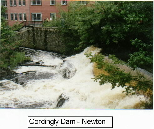
The Rt. 16 roadway was part of the "old Natick Road" which connected Cambridge and Natick starting about 1700. Prior to that the road was part of the Sherborne Road, which went from Boston to Sherborne along the same Washington Street coridor. As early as 1690, a grist mill, was operating on the Wellesley side (then Needham)of the river. By 1790, after a series of other mills were established in Lower Falls, the first paper mill was built. This field stone building at 2276 Washington Street is still erect on the right. For most of the 18th century, paper making remained an important local industry by harnessing the power of the Charles River. Through a series of dams, these mills thrived through most of the first half of the 18th century. Two of these dams, the Cordingly Dam and the Finlay Dam are still located immediately to the right upon crossing the bridge into Newton. The Cordingly Dam also has a footbridge (Mary Hunnewell Fyffe Footbridge) across it. From this footbridge it is possible to view and hear the thunder of the Charles River below as it travels through the dam. There are several other historical buildings in the heart of the Lower Falls village. These buildings include Boyden Hall at 2366 Washington (1867 - Italianate and Colonial Revival), the building at 2345 Washington Street, the 1750 Georgian style Baury House at 2349 Washington Street (the oldest building on the Marathon course along with the Old Stone Tavern building in Hopkinton, also built in 1750), the William Curtis House at 2330 Washington Street (1839 - Greek Revival). All of these properties are within the Lower Falls National Register of Historic Places district. Many other buildings and industrial structures were razed in Lower Falls as part of a federal and state urban renewal project that started in the early 1970's. Immediately outside of the village center, the Allen Crocker Curtis House (former Pillar House restaurant) was until 2004 situated on the right set back on the corner of Quinobequin Road. It was a massive well-preserved white Greek Revival structure that was built in 1828. In 2004 it moved to Weston for use as a private residence. The site, owed by the State, will now be used to expand the Rt 128 entrance.

 After the American Ex. POW Bridge, which is above the 1950's Route 128/95, one comes to the intersection of Beacon Street. This same Beacon Street commences at the State House in Boston and proceeds to this ending point as a dirt road in Newton. The name "Beacon" refers to one of the three main hills (Beacon, Mount Vernon, and Pemberton)on the original Shawmut peninsula land mass. Of the three original hills, only Beacon Hill remains. This stretch is also referred to as "Hell's Alley" by runners because it is so isolated. At this point on Washington Street, one is traversing the Village of Waban on the right. As one proceeds past Beacon Street past the Woodland Golf Club on the left, one touches the Village of Auburndale.
At mile 17.65 a modern fire station stands. As one makes the turn at the intersection of Washington St. (Rt. 16) and Commonwealth Ave. (Rt. 30), at this point one is now touching the Village of West Newton. At this turn, the infamous hills along Commonwealth Avenue in Newton begin. Commonwealth Avenue in Newton is a continuation of the Commonwealth Avenue that starts in the Back Bay of Boston. The Newton section was planned as the "Newton Boulevard". In 1878, Frederick Law Olmsted was hired to design this avenue in the same park tradition of the Emerald Necklace in Boston. The Commonwealth Avenue in Newton, however, was never meant to be officially part of the Emerald Necklace. Nonetheless, Commonwealth Avenue was planned to complement the green park system, known as the Emerald Necklace. The avenue was originally designed to have two carriage lanes, with one on either side of a wide median landscaped area. In 1900, the trolley lines were laid within this median to take passengers from Boston all the way to Norembega Park in Auburndale, which is adjacent to the Charles River. By the 1950's the trolley lines were removed and one of the carriage lanes was widened as a primary automobile route. Commonwealth Avenue is now a major contributor to Newton's nickname, the "Garden City".
As one proceeds up the first Commonwealth Avenue hill, one passes the Brae Burn Country Club at the apex of the hill. The golf club has a very large Colonial Revival building (c. 1897) set just back from the Avenue (Rt. 30).
After the second shorter hill, one reaches Newton City Hall and Newton War Memorial on the right, which is within the Village of Newton Centre. This immense 1932 Late Georgian Revival structure is an imposing presense along a mostly residential street.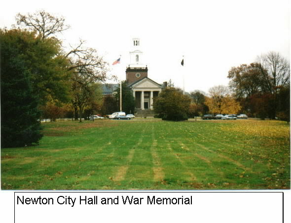 The beautiful City Hall park, with Bulloughs Pond in front, was designed by the Olmsted Brothers, the successor firm to Frederick Law Olmsted. Prior to its construction, Newton City Hall was located in the Village of West Newton in the northern part of the City. The selection of the Newton Centre site was meant to be a unifying force for the fourteen villages.
Across from the City Hall and beyond the carriage lane is the Johnny Kelley Running Sculpture called "Young at Heart", which was sculptured by Rick Muno. The sculpture portrays the 2-time Boston Marathon winner at age 27 and at age 84. Right after the Centre Street intersection is the 20 mile mark. The Newton Tennis and Squash Club, organized in the early 20th century, is on the right. Then, on the left is the Temple Emanual temple. This Jewish congregation, set back one street from Commonwealth Avenue just before the Ward Street intersection, has been a strong Jewish influence in the neighborhood since the 1920's. Several businesses cater to the Jewish population is this area.
As the third Newton hill arrives, one enters the Commonwealth Avenue National Register of Historic Places District. The district covers both sides of the street and goes to Waban Hill Road, which is on the descent side of the final Newton Hill. Waban Hill Road, which is accessed from the carriage lane, is the location of the Reginald Fessenden House, which is a National Historic Landmark. This distinction honors the contributions of Reginald Fessendon to the field of wireless communications. This is one of only three National Historic Landmarks along the entire 26.2 mile route. (The others are Trinity Church and the Boston Public Libary in the Back Bay of Boston.) The final Newton hill, known affectionately as the last of the "Heartbreak" hills is officially known as Waban Hill. This challenging hill, which takes a great deal of effort for most runners, is approxiately 320 feet above sea level and rises for almost one-half mile when it ends at the Hammond Street intersection.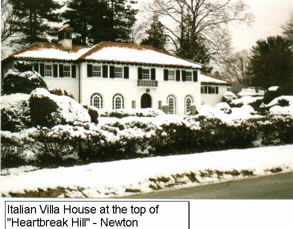 This section of Commonwealth Avenue is also located within the Village of Chestnut Hill in Newton.
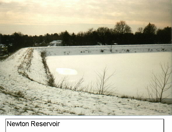 As the descend begins, the Newton Reservoir comes into view nestled across the carriage lane up the embankment.
As the well-earned descent is made down Waban Hill, Boston College is on the right, which straddles the Boston boundary. The main college entrance is at mile 21.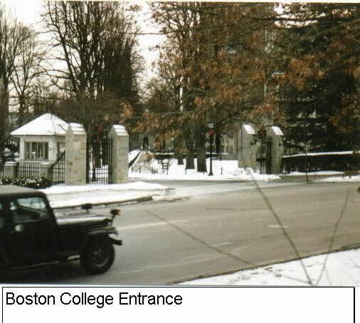 Most of the academic buildings are in Newton, while the athletic facilities are in Boston. Boston College opened its first building at site in 1909 on the location of the former Lawrence farm after it's start in the South End of Boston. The prominent Gasson Hall, with a Gothic Revival tower, is the prominent building just beyond the main Commonwealth entrance. The Gasson was named for Thomas J. Gasson, the Boston College president that presided over the move from the South End to Chestnut Hill. The college generally refers to the fact that it is in Chestnut Hill, which is a somewhat unique combination of three cities: Newton, Brookline and Boston. The only official designation for this district is from the U.S. Post Office. The College location is also known in recent years as the Heights. Just past the main Boston College entrance is the St. Ignatius of Loyala Church, which was built in 1948 in th Gothic Revival tradition. Today, the Jesuit Boston College has approxiately 13,500 students. It is one of four private colleges in Boston that participate in Division I athletic programs. The other three are Boston University, Harvard University, and Northeastern University.
At the base of the hill on the right is a stone monument that commemorates the fact that Commonwealth Avenue was once an Indian trail.
BRIGHTON (BOSTON) - MILE 21.6
Just past Boston College is the boundary for the Brighton neighborhood of the City of Boston, which is in Suffolk County. Until 1779, Brighton was known as Little Cambridge and was officially part of the Town of Cambridge. From the Brighton line to Cleveland Circle has been called the "haunted mile" by many runners. This designation relates not only to the presence of the Evergreen Cemetary but also to the knowledge that the rest of the course is all down hill.
At the Brighton boundary, the Route 30 and Commonwealth Avenue designations continue. This Brighton portion of Commonwealth Avenue was constructed in 1892 just as Beacon Street was completed. Although this portion of Commonwealth Avenue was also planned by Frederick Law Olmsted, it's residential developments never matched those of Beacon Street. As a consequence, the building development of this Brighton side of Commonwealth Avenue didn't fully transpire until about 1925. However, the trolley line that now ends at Boston College, but formerly continued on into Newton, was operational by 1890.
Passing along Commonwealth Avenue in Brighton, which was orginally known as South Street, we pass the former Catholic Archdiocese of Boston's Chancery and it's St.John Seminary on the left. The former is a 1926 Italian Renaissance building that was until 2004 the home for the Catholic Archbishop. In 2004 the home and most of the property around the former Chancery was sold to Boston College, which is in the process of developing plans for the buildings and the site. Across from the Chancery is the Evergreen Cemetary. It was built in 1850 as a smaller version of the park-like Mt. Auburn Cemetary in Cambridge. In both cemetaries, the natural landscapes are preserved and enhanced by laying out the avenues and paths to complement the topography and the vegetation. The effect at this former Aspinwall Woods is very pleasing and pastoral.
Further down Commonwealth Avenue is the Temple Bnai Moshe, which was built in 1951 at 1845 Commonwealth Avenue at the height of the Jewish movement into Brighton. At the intersection of Commonwealth Avenue (Route 30) and Chestnut Hill Avenue, the trail takes the right onto Chestnut Hill Avenue as the Chestnut Hill Reservoir comes into view on the right.
Once on Chestnut Hill Avenue, the Aberdeen section of Brighton is on the left. Aberdeen was laid out in the 1890's as a planned suburban residential development. This area is filled with rich architectural styles ranging from Queen Anne Revivals, Jacobethans, and Rustic Shingles. Also, most of the street names retain their English and Scottish "shire" antecedants. In 2002, the City established the Aberdeen Architectural Conservation District. A Commission will now review proposed architectural and landscape changes before they are implemented.
On the right side, the Chestnut Hill Reservoir grounds come into full view.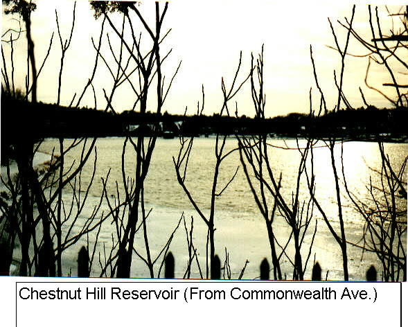 The entire reservoir area, including the water, buildings and land is listed in the National Register of Historic Places. It is also listed as a City of Boston Landmark. The reservoir was originally a natural basin with marsh and meadow lands before it became the water supply for the City of Boston in 1870. The water area (Bradlee Basin) is 87 acres large and 20 feet deep. It has a scenic circumferial footpath that is 1.7 miles long. There are two grand pumping stations serving the reservoir: the High Service Pumping Station (1887) in the Richardsonian Romanesque tradition and the Low Service Pumping Station (1898). The former station is also a designated national engineering landmark for its interior technology. The latter was built in the Beaux-Art Classical style. In 2003, the reservoir was turned over to the State's Department of Recreation and Conservation, which is in the process of developing a passive and recreational park. In 2004, the two pumping stations were sold to a private developer which has begun developing residential condominiums through preservation of the buildings as well as newly constructed adjacent units.
At the end of Chestnut Hill Avenue, the route reaches [President Grover]Cleveland Circle. The original name of this large business and residential area was Beacon Circle and was planned as an important grant parade area at the end of Beacon Street. As the left turn is made onto Beacon Street a newly installed ornate Clock Tower in the center of the huge "circle" comes into view. Today the busy and congested Cleveland Circle area is full of automobiles and pedestrians throughout the day and night. The expansive paved Circle is a mix of residential and commercial uses that cater to college students and recently graduated students. It is also the starting point for one of the Massachusetts Bay Transit Authority's (MBTA)Green Lines into Boston.
BROOKLINE - MILE 22.6
After a short distance on Beacon Street in Brighton, the route proceeds onto the Beacon Street of the Town of Brookline and reenters Norfolk County. Brookline was first known as the Muddy River Hamlet as early as 1638 after the river of the same name. The MBTA's Green "C" line in the median strip is a trolley passenger line that proceeds into Boston.
The town remained primarily agricultural until the Boston-Worcester Turnpike (Rt. 9) opened and the Mill Dam Road extended Boston's Beacon Street into Brookline in 1806 and 1821 respectively. After this period, the town made rapid advancement as a desirable residential commuter town. The town's residents have always valued their independence and resisted six attempts to be annexed by the City of Boston and thus has remained an independent town. The final attempt was in 1890.
Beacon Street was initially laid out as a country road in 1851. In 1886, it was redesigned and developed according to the landscaping plans of Frederick Law Olmsted. The trolley line in the central strip was added in 1887. The initial brick townhouses were all single-families which added to its image as a grand French boulevard. Most of these buildings have now been converted to multi-units and mixed residential and business use, but retain their grand appearance. This appearance was greatly enhanced due to the fact that Beacon Street in Brookline was originally built as a 200 foot wide boulevard. Even at the beginning of the 21st century it is still 160 feet wide. Much of this Beacon Street extension in Brookline is listed in the National Register of Historic Places.
Along Beacon Street on the way to [President George] Washington Square, the intersection of Washington Street and Beacon Street, there are several local landmarks. One such landmark is the All Saints Church (1926) on the right at 1773 Beacon Street. After passing through Washington Square with its prominent historic Clock tower, the route continues on Beacon Street toward Coolidge Corner, a thriving and busy business district. On the right is the prominent Brookline Trust Company at 1341 Beacon Street.
At Coolidge Corner (corner of Beacon and Harvard at mile 23.9) is the former but still brilliant S.S.Pierce Building (1899) at 1324 Beacon Street. This former masonry department store is an outstanding example of a Queen Anne Style commercial building and is very distinctive. The Pierce replaced the Coolidge Brothers Store building (1857), from which the corner retains its name. The busy upscale business area of Coolidge Corner also has a prominent clock tower and a very attractive trolley shelter, with red clay tiled roofing. Upon leaving Coolidge Corner and heading towards Boston, there is the All Saints Episcopal Church at 1793 Beacon Street. This church, listed in the National Register of Historic Places, has a magnificant rosette-shaped stain glass window facing Beacon St. The Richmond Court Apartment building further down on the right at 1209 Beacon Street is also listed in the National Register of Historic Places. Further down Beacon Street is the Temple Ohabei Shalom at 1187 Beacon St. This is very large and prominent edifice that is the home for a substantial Jewish congregation. A little further down Beacon on the left is the Cottage Farm National Register Historic District which fronts onto Beacon Street but has most of its buildings between Carlton Street and Armony Street. This district includes the Hall's Pond Sanctuary, a natural wildlife area that has several different types of mammals, fish and turtles.

S.S. Pierce Building - Brookline
BOSTON - MILE 24.8
Moving along Beacon Street, the route moves into the City of Boston side of Beacon Street and back into Suffolk County. Boston was originally known as the Town of Trimountaine when it was founded by John Winthrop. In 1630, the name was changed to Boston after a British town of that time. The name refers to the three original hills (Beacon, Mt. Vernon, and Pemberton). The trail then quickly moves into Aububon Circle, which was originally known as Burlington Circle. The circle was once a part of Brookline, but was one of the areas that was successfully annexed by the City of Boston in 1870. The main street through the circle is Park Street, which was originally known as Audubon Road. This street was developed to connect Beacon Street to the Olmsted park roads. Audubon Circle was built up between 1890 and 1915 with masonry single and 3-6 family apartment buildings. The architectural styles in and around the circle include a wide variety of Queen Anne Revivals, Romanesque Revivals, and Classical Revivals. The most prominent building is the Second Church in Boston, which is a very visible Georgian Revival landmark. The church is now operated as the Ruggles Church. Due to the close proximity to its main campus on Commonwealth Avenue, Boston University owns many of the buildings in the circle and area for use as academic and dormitory space. As such, Audubon Circle has acquired a distinctive urban collegiate atmosphere. Boston University, with most of its campus adjacent to the Charles River, has approximately 30,000 students. The university is one of the largest private universities in the country and has one of the largest foreign-born student bodies.
Beacon Street then continues towards Kenmore Square after passing above the Massachusetts Turnpike (Route 90). Along the way on the right at 693 Beacon Street is the former Edison Electric Illuminating Company building (1916). It was designed in the Academic Italian Renaissance style with a granite and cast-iron facade.
The route then moves into the expansive Kenmore Square at mile 25.1. Prior to the 19th century land filling of the Back Bay, the Kenmore Square area was a marshland adjacent to Sewall's Point in Brookline. The point was named for Samuel Sewall, the judge that presided over the Salem witch trials of the 17th century. In 1821, the Mill Dam Turnpike , a 1 1/2 mile long and fifty-foot wide bridge from the present Public Garden area to the Kenmore Square area, was constructed over the waters of the Great Bay (Back Bay). The only land area in the bay was a peninsula jetting out from the present Roxbury neighborhood. The turnpike was later extended into Brookline along Beacon Street. In 1831, the Boston & Worcester Railroad passed through the southern portion of the Kenmore area on its way to the west. After the Back Bay filling, the Kenmore area was laid out in the 1860's and 1870's for light industrial and commercial facilities. The major use that eventually took hold was that of lodging. By 1920, when the square was designated as Governor's Square, six hotels were operating in Kenmore Square. This included the Hotel Buckminister (1900) which is a large Beaux Arts and Renaissance Revival structure, that still wraps around Beacon and Brookline Streets as one enters the square. The hotel tradition was recently reestablished with the opening of the Hotel Commonwealth, just outside the square on the right on Commonwealth Avenue. The residential buildings that were constructed were built as single-families but later converted into multifamily and commercial use. The most visible landmark in Kenmore is the enormous "CITGO" neon sign, which sits atop 600 Beacon Street, in the heart of the square. It is 60 feet by 60 feet and contains at least 2000 neon tubes. Further, this sign has been a reference point in the Boston area since its erection in 1965. The red,white and blue "CITGO" sign (and its predecessor "City Services" sign replaced a similarly large "Peerless Motor Oil" sign, which was installed in 1916.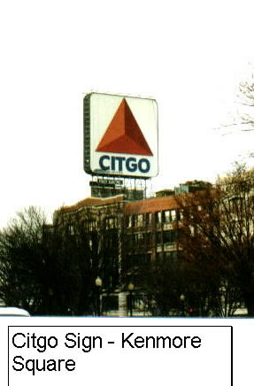 From the middle of the Square, Fenway Park is within view on the right. This 1912 professional baseball stadium, with a seating capacity of approximately 33,000, is home for the American League's Boston Red Sox. On Marathon Day, a baseball game is scheduled so as to end as the lead runners pass through Kenmore Square.
The route moves out of Kenmore and back onto Commonwealth Avenue (Route 30). This grand avenue, designed by Frederick Law Olmsted, includes a magnificant central linear park-like mall and two wide transportation corridors. This park is an integral connecting feature of the Emerald Necklace, which goes from the Boston Common to Franklin Park and also includes the Arnold Arboretum, the Jamaica Pond, Olmsted Park and the Riverway. This linear park, a City of Boston Landmark, is the beginning of Boston's Back Bay. At the corner of Commonwealth and Charles Gate East is the Leif Erickson Memorial Statue, honoring the Norsman that explored North America in the year 1000.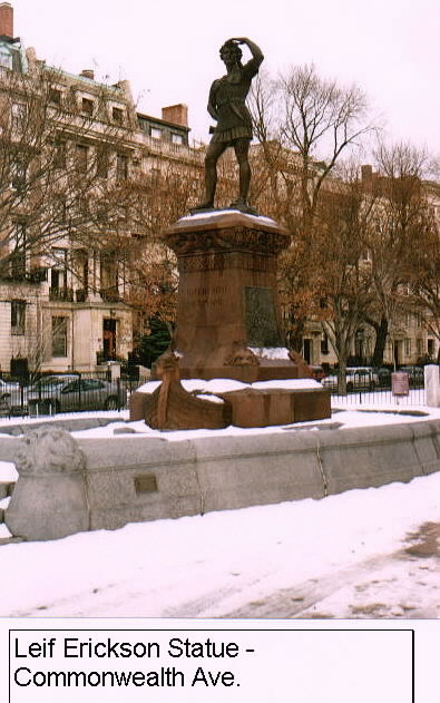 . The statue, dedicated in 1887, was sculptured by Anne Whitney (1821-1915). It was originally at the Massachusetts Avenue end of the block and moved to its present location in 1917. Immediately following the statue, the Muddy River passes beneath Commonwealth Avenue.
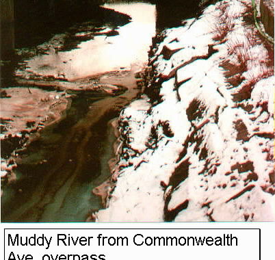
Until 1857, most of the present Back Bay was under water. It was a shallow bay or estuary of the Charles River that was situated between Boston Common and the boundary for the Town of Brookline. Prior to 1857 the Shawmut Peninsula, comprising the oldest parts of Boston, was still intact. But in 1857 a massive Back Bay public works project commmenced to address the sewerage problem created by the bay. For almost 60 years dirt fill from Needham was loaded on a specially-constructed railroad line and transported nine miles and then dumped into the bay. At its peak, there were 3500 carloads coming from Needham daily. By 1890, over 450 acres had been added to the Back Bay district. The filling of the Back Bay was truly Boston's first "Big Dig". Following Arthur Gilman's plan for residential development, new streets were laid out in the French boulevard tradition and Victorian residences were constructed throughout. By 1918, when the Back Bay construction was essentially completed, over 1500 buildings had been built on the newly filled land. In the 1850's and 1860's, the Second Empire brownstone and masonry buildings predominated. In the early 1870's, brick masonry Rustic Gothic buildings were the predominate style. In the late 1870's Queen Anne and Romanesque Revivals became the predominate style. And, in the 1880's, the Italian Renaissance and French Chateauesque buildings predominated. Through the use of deed restrictions, cornices, roof lines, setbacks, materials, heights, and massing were carefully controlled to create splendid continuous streetscapes. The end result was a magnificant district of French-influenced routes and continuous rows of single-family brownstones, masonry townhouses, and mansions. Since 1966, the Back Bay has been maintained and preserved and maintained as one of the finest planned architectural districts in the United States through the mandatory controls managed by the Back Bay Architectural Commission. This City of Boston commission oversees the responsibilities of this district which is also listed in the National Register of Historic Places.
At the corner of Commonwealth and Hereford in the Back Bay, the route takes a right and proceeds onto Hereford Street to the end of that street. The route intersects with Newbury Street, with its well-known international shops and art galleries. On the right corner of Newbury and Hereford is the Boston Architectural Center (1967), a college-level professional education center. The center, organized as the Boston Architectural Club in 1889 on Beacon Hill, is the 6th oldest architectural design school in the United States. At the intersection of Hereford Street and Boylston Street the publically-owned and operated Hynes COnvention Center, which originally opened in 1970, is straight ahead and the Institute of Contemporary Art, which moved into the former 1883 Richardsonian Romanesque police station in 1975, is on the right. The Institute, which was founded in 1936, is the oldest non-collecting contemporary museum in the United States. The Hynes is named for John B. Hynes, a Mayor of Boston in the 1950's who defeated James Michael Curley three times. The route then takes a left onto Boylston Street. Boylston St. is named for Zabdril Boylston, the first person to administer the smallpox innoculation in the United States. He undertook this inoculation during an epidemic in Boston in 1721. Once on Boylston Street, the end of the long route at Copley Square comes into view. Just after the Hynes Convention Center on the right is the Prudential Center complex. It was Boston's first megastructure with 52 floors when it was built in the 1960's over abandoned railroad yards. It is now topped by the John Hancock tower at 60 stories. The Prudential was built as a result of a massive urban renewal project. For many years, the Prudential was also the ending point for the marathon course.
The course then proceeds into [John Singleton] Copley Square, named in 1883 after Boston's famous 18th century artist. This lovely square was not actually part of the original Back Bay plan. Rather, it was an unplanned square that came about in 1883 due to the intersecting cross streets. The 26.2 mile route officially comes to an end in front of the Boston Public Library's 1964 addition, which is on the right heading into the square. The addition was designed by internatioanlly-admired architect Philip Johnson. The original building, built in 1880 and facing the square, was designed by McKim, Mead and White. It's main entrance doors were designed by Daniel Chester French and the third floor has murals painted by John Singer Sargent. The entire interior is highly ornate with carved marble throughout. Bates Hall, the second floor research library research center, is an architectural jewel. The Boston public libary system, established in 1848, was the first publically supported municipal library in America. On the left side of Boylston Street and facing the square is the Old South Church (1875), built in the North Italian Gothic style. This church is listed in the National Register of Historic Places. The original public park of 1883 that comprises Copley Sqare was redesigned in 1969 and again in 1995. The main structure facing the square is Trinity Episcopal Church. In 1875 it was Henry Hobbs Richarson's first major design commission and is considered to be one of the great architectural treasures in the United States. It along with the Boston Public Library are both National Historic Landmarks, the highest recognition offered by the National Park Service and the U.S. Department of the Interior. The Copley Plaza Hotel (1913), which faces the square was built on the footprint of the original Museum of Fine Arts. The latter was razed when it relocated to Huntington Avenue. The Hancock Building, a 60 story glass tower, that was built in 1973 and designed by the famous I.M. Pei, is just beyond the square and Trinity Church. The Hancock continues to be the tallest building in New England.

