|
Hickory Canyon Natural Area
430 acres
2 Trails:
.25 mile and 1 mile
67 South left to JCT K to JCT C, or 32 East to JCT C. Sprott Road
Contact:
MDC 573-751-2479
Hawn State Park
4,953 acres
3 Trails:
10 miles (2 loops)
and 1 mile
Route 32 west to HWY 144.
Contact:
Department of Natural Resources,
12096 Park Drive, Ste. Genevieve, MO 63670
1-800-334-6946 or 573-883-3603

Pickle Springs Natural Area
256 acres
1 Trail:
2 miles
Route 32, HWY AA
1.7 miles Dorlac Rd.
Contact:
District Forester, Southeast Forest District, 2302 County Park Drive, Cape Girardeau, MO 63701
573-290-5730
|
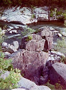
Hickory Canyon Natural Area
67 South left on JCT K, or 32 East to JCT C. Turn onto Sprott Road.
Provides short hiking trails in 430 acres, that give a glimpse of the distinctive bluffs and sandstone rock canyon found in this natural area. At Hickory Canyons, the canyon walls are impressive, forming 100 foot high bluffs. The cool, moist, shaded cliff environment is home to many native fern species along with club moss. The steep mile trail of terrain passes through the mesoic sandstone forests and across the creek at times.
Trails: A .25 mile trail and a steep 1 mile trail.
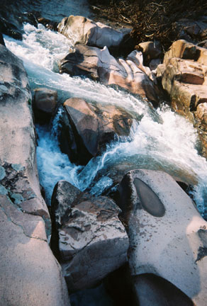
Hawn State Park
Route 32 west, on HWY 144.
 This 4,953 acre park was created by the Ozark Chapter of the Sierra Club. The park contains the Pickle Creek Natural Area and Whispering Pine Wild Area. Its waterways are Pickle Creek and River Aux Vases. Scenic views are LaMotte Sandstone basin eastern Ozarks, Canyon ribbed valleys, vertical cliffs, and sandy bottom streams. The River Aux Vases sandstone bluffs are a highlight. This is an area of geological discovery where sedimentary sandstone and igeneous granite are found together.
Trails offer wilderness activites, backpacking, bird watching and nature study.Whispering Pine Trail (10 miles) Two Loops, north is 6 mi. and south is 4 mi. For day trips or backpacking hikes. Water can be drank while on the trail from the Pickle Spring but treated. Pickle Creek Trail ( 1 mi.)
This trail follows the beautiful shut-ins stream. Sandy bottom creek strewn with water sculpted granite boulders. Trees: Lofty shortleaf Pine, white oak, hickory, red leaf maple, flowering dogwood. Plants: Native grasses and wildflowers (natural now fire burns for native plant recovery) rare and unusual plants thrive on this acidic soil. Wild Azaleas, rosettes of Rattlesnake orchid, hay-scented fern, fern-clad moss, partridge berry, ground pine. Rock: igeneous granite rock, Lamotte sandstone, banded cyrstalline rock-metamorphic gneiss. Waterways: Pickle Creek and River Aux Vases. Animals/Birds/Fish: wild turkey, white-tailed deer (many), skink, bobcat, pine-warblers, chickadees, owls, scarlet tangeers, "wingspanned" hawk. 21 species of fish, rainbow darter, striped shiner, silver-jaw minnow. Activities: Picnicking, camping and guided nature walks.
Return to Top
Pickle Springs Natural Area
Route 32, HWY AA for 1.7 miles to Dorlac Rd.
Pickle Springs Natural Area is a special place consisting of biological and geological features. Cool moist canyons, spectacular views from sandstone bluffs. There are several rare plants and beautiful wild azaleas. The geology and its effects on the plants makes this natural area truly unique, because its features found here occur in few other places. The area contians the ground cedar, white smooth violet, shining nut-rush and hay-scented fern.
Formed 500 million years ago when sand deposited in a maze from a braided river channel then cemented together to form sandstone. This sandstone, Lamotte, outcrops a small portion of the St. Francois Mountains. During the time of glaciers and acidic soils, mammoths wandered in the cool canyons. Because of this unique combination of rare plants and geologic features this area is designated a Missouri Natural Area and Landmark.
Trail Through Time (2 mile trail)
Areas of notice are The Slot, Double Arch, Keyhole, Pickle Creek, Mossy Falls, Spirit Canyon, Dome Rock Overlook, Pickle Spring, and Rockpile Canyon.
Trees: Lofty shortleaf Pine, white oak, hickory, red leaf maple, flowering dogwood. Plants: Native grasses and wildflowers (natural now fire burns for native plant recovery) rare and unusual plants thrive on this acidic soil. Wild Azaleas, northern White violet, rosettes of Rattlesnake orchid, lichen, little bluestem, poverty grass, hay-scented fern, fern-clad moss, partridge berry, ground pine. Rock: igeneous granite rock, Lamotte sandstone, banded cyrstalline rock-metamorphic gneiss. Waterways: Pickle Creek and Bone Creek. Animals/Birds/Fish: Much the same as Hawn State Park. The natureal area is preservation area and landmark.
Return to Top
John James Audubon Trail & Natural Area
55 to HWY T, to Womack on Bidwell Creek Rd. to FS2199 or between State Rd. WW and T.
The trail is located entirely in the Mark Twain National Forest. At Bidwell Creek there is the 8 mile Coldwater Creek Trail and Salamander Hollow Natural Area Trail which is a 5 mile trail. The trail follows the hills of the ozarks with an elevation change of 300 ft. The terrain is steep and rocky, through forest and glades and there are several stream crossings. There are 3 primitive campsites. Excellent for hiking, backpacking and nature study. The trail is ideal for a day hike or a short 2-day backpacking trip.
Trails: 13 miles, two loops 5 and 8 mi
Magnolia Hollow Conservation Area
HWY 61 North. HWY V to White Sand Road
The area is bordered by Establishment Creek and Schmidts Island. The forests are dense and diverse of hardwood and glades, containing a variety of trees, shrubs and wildflowers. There are two hiking trails, 2 miles and 5 miles, traveling steep bluffs with scenic views along the Mississippi River.
Return to Top
|