|
Millstream Gardens
684 acres
Trails: Turkey Creek, 2.5 mi
HWY 72 west
Contact: Perryville, MO 63775. (573) 547-4537
|
Millstream Gardens & Silver Mines Natural Areas
HWY 67 or 21 to HWY 72 County Road D.
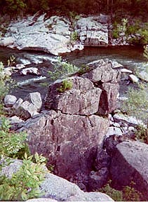
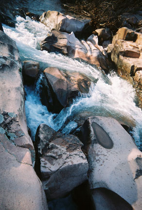
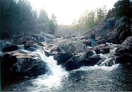
The St. Francis River is part of the Missouri Natural Area System, the waters of the St. Francis River push their way around granite rocks, through the heart of Millstream Gardens and Silver Mines. Igneous rock carved by the river areas called shut-ins are found in both Natural areas. The St. Francois Rivers flows though these shut ins to create the only whitewater in Missouri. Used by kayakers in the spring.
Tiemann Shut-ins, located at the central part of Millstream Gardens, is spectacular. Turkey Creek Trail (2.5 miles) follows the river and connects the two areas. Trails on each side of the river lead to remnants of the area's mining history and interesting rock formations. The areas woodlands are composed of mostly oak, hickory and pine in the uplands, ash and elm and maple along the river. A wide variety of animals live here. Wildlife species vary from the rare collard lizard on the glade areas to the more common white-tail deer that inhabit the uplands. Enjoy the flowering dogwoods, redbuds and woodland wildflowers in spring and spectacular colors against the rocky landscape in fall. Watch for wild turkeys, white-tailed deer, lizards, hawks, songbirds, squirrels, raccoons, opossums, mink and eastern chipmunks while visiting both areas.
Turkey Creek Trail: This trail extends from USFS Silver Mines Rec. Area, Riverside picnic and boat ramp at Hwy D Bridge at Millstream Gardens Conservation Area a .5 mile south of HWY 72. It follows the 200 ft riverside bluffs above the Silver Mine Shut-Ins. The trail becomes floodplain level after crossing Turkey Creek footbridge. The trail continues north and upstream to a path to the Tiemann shut-ins and 20 acres of the St. Francis River Natural Area. Tiemann Shut-ins Trail is paved at the overlook onward to the parking lot, about 1 mile. Highlights along this trail along the whitewater section of the St. Francois River are Silver Mine Dam and Shut-in, Mud Creek Shut-In, Bluff Hole, Tiemann Shut-in, Rapid Drop, Double Drop and Cats Paw.
 Silver Mine Trail: A second trail originates and ends in the USFS riverside camp loop, HWY D, across the St. Francis River from the Turkey Creek Trailhead. Silver Mine Trail is a 1 mile loop, a rugged path that follows the bluffs of the river upstream to the 1936 dam Silver Mine. The old mine shaft is called the "Air conditioner", because of its cool air. This hiking trail along the river provides a view of the rocky landscape and woodland life. Silver Mine Trail: A second trail originates and ends in the USFS riverside camp loop, HWY D, across the St. Francis River from the Turkey Creek Trailhead. Silver Mine Trail is a 1 mile loop, a rugged path that follows the bluffs of the river upstream to the 1936 dam Silver Mine. The old mine shaft is called the "Air conditioner", because of its cool air. This hiking trail along the river provides a view of the rocky landscape and woodland life.
Silver Mine Historic Trail: The third trail is west of Riverside Camp loop, HWY D. A .25 mile Historic Trail loops through the foundations, streets and sidewalks of the ghost town of Silver Mountain. From 1877 to 1938 the village housed workers from the Einstein
Silver mining Company.
Amidon Memorial Conservation Area - Castor River Shut-Ins
Country Rd 208 E. of Fredericktown*
  Amidon Memorial Conservation Area-Castor River Natural Area is 1,632 acres and has two trails, Cedar Glade, 1 mile and the old mill 2.5 mile nature walk. The Cedar Glade trail leads to the dramatic shut-ins of pink granite on the Castor River.
Forest and glades also support a rich mix of wildlife, bobcat, mink and turkey. This granite glade area contains over 136 plant species and six natural communities.
The Castor River supports at least 35 fish species and the golden and spothanded crayfish found only in the Ozark waters.
Cedar Glade trail is a 1 mile loop and leads to dramatic water carved pink granite boulders of the Castor River shut-ins. The 209 acres Natural Area is located in the upper 2.5 miles of the river.
Hahns Mill Trail is a path that follows along the Castor River from the Cedar Glade trail and leads to the old Hahns Mill.
 
It is an all-seasons nature walk!
 Marble Creek Recreation Area
HWY 67 Country Road or HWY E. 573-438-5427
Features camping along the colored dolomite rock formations and at the millpond and dam there are picnic sites, fishing and swimming. This area is very peaceful in off season.
Small trails leading to campsites and Marble Creek to the stream banks. Marble Creek Shut-ins, Ozark Trail section begins at Crane Lake, in the Mark Twain National Forest.
Return to Top
Cathedral Canyon
US HWY 67, HWY E, CR511, 2104
 This deep canon is very picturesque in the St. Francois Mountains. There are scenic 400 ft. high rock bluffs that tower over the boulder filled stream. Glade Dotted Black Mountain, elevation 1,502 ft., and Trackler Mountain, elevation 1,400 ft., surround the Cathedral Canyon and Lower Rock Creek, flows into St. Francois River. Wolfhollow trail ( 4 mile) begins past the gate on the forest road, across a stream, the first trail junction on the left, and it is roundtrip. The unmarked trail through the forest is 1 mile long. The forest road travels uphill to Trackler Mt. The worn path of the 1 mile trail passes between two ridges and arrives at Lower Rock Creek. From this point the Dark Hollow of Lower Rock Creek travels upstream following the Lower Rock Creek bed. A path cuts through overgrown terrace and at times crosses the stream. Hike upstream three bends or 1 mile to enter the Cathedral Canyon. In the canyon there are rockbeds, boulders, streams or rushing waters, in spring and many areas for rock climbing and nature study. Maintained by USFS. This area is very peaceful and a wilderness hike of rugged terrain to access the waterway. This deep canon is very picturesque in the St. Francois Mountains. There are scenic 400 ft. high rock bluffs that tower over the boulder filled stream. Glade Dotted Black Mountain, elevation 1,502 ft., and Trackler Mountain, elevation 1,400 ft., surround the Cathedral Canyon and Lower Rock Creek, flows into St. Francois River. Wolfhollow trail ( 4 mile) begins past the gate on the forest road, across a stream, the first trail junction on the left, and it is roundtrip. The unmarked trail through the forest is 1 mile long. The forest road travels uphill to Trackler Mt. The worn path of the 1 mile trail passes between two ridges and arrives at Lower Rock Creek. From this point the Dark Hollow of Lower Rock Creek travels upstream following the Lower Rock Creek bed. A path cuts through overgrown terrace and at times crosses the stream. Hike upstream three bends or 1 mile to enter the Cathedral Canyon. In the canyon there are rockbeds, boulders, streams or rushing waters, in spring and many areas for rock climbing and nature study. Maintained by USFS. This area is very peaceful and a wilderness hike of rugged terrain to access the waterway.
Return to Top
Rockpile Mountain Wilderness Area
US 67, to Fredericktown, W on Hwy C at Cherokee Pass, JCT CR406/Tower Road west to FS2124. (or 67 to E, to O to Tower Road.)
Rockpile Mountain wilderness area, is 4,131 acres, and one of the eight in the Ozark mountains, it is the smallest in acreage yet it holds many archaeologist mysteries. At the crest of Rockpile mountain, elevation of 1, 270 ft., there is a large circle created of granite rock. This trail is for hikers that desire solitude in beautiful surroundings. The trail up and down to Rockpile Mountain and Cave Branch is a little overgrown and eroded. The route of an old forest-logger road maybe hiked or back packed on this rugged 10 mile trail. Start early or stay overnight. Bring a map and compass, allow ample time, to explore the wilderness area the bluffs, Turkey Hollow, and St. Francois River.
Little Grass Mountain Trail, is a 2 mile (point to point)trail for a shorter steep hike Rockpile Mountain Wilderness Trail is 7.5 miles (loop) The trails total 10 miles. The trail begins at Little Grass Mountain, elevation 1,306 ft., of the Rockpile Wilderness Area, at the registration box. The forest mountainside path switches back and forth across the slope of the Little Grass Mountain, descending 300 ft. to a lower ridge. A path then leads 2 miles to an old road T junction to connnect the trail with the Wilderness loop.
Wilderness loop is 7.5 miles, the loop is to Rock Pile Mountain and Cave Branch. At the junction, this the begininng and end of the trail, walk up the old ridge forest road to Rock Pile Mountain, 2 miles, elevation 1,270 ft. At the mountain crest is a cedar glade where the trail follow an igneous rock ridge. The rock pile circle will be on the right. The trail then descends the southwest slope, always bear right, and this gradually follows the ridges to Cave Branch, about 2 miles. (500 ft.) The next .5 miles the loop trail crosses the branch and ascends a ridge bear right/east to the St. Francis River, Turkey Pen Hollow, and the river bluffs. After exploring the wilderness area continue for 2 miles hiking east, along the ridges above Cave Branch to the junction leading back north on the Liitle Grass Mountain trail.
Stouts Creek Shut-Ins
Stouts Creek Shut-Ins are of igneous rock shut-ins, cascades, and waterfalls produce Big Creek of bass, River crayfish was once abundant in Stouts Creek and exotics species in two nearby streamsand areas, Stout's Creek near Ironton, Big Creek near Sam A Baker, and The Black River runs through Johnson's Shut-ins State Park.
Return to Top
|