Mark Twain
National Forest
|
Johnson Shut-ins State Park
HWY 185 to JCT N. HWY 21 or 32 to HWY 185. 573-546-2450.
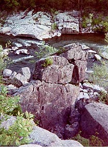
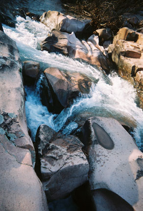
A 8,670 acre park. This natural water park is created by the East Fork Black River flowing through the canyon gorge. The water cascades through large smooth boulders of igneous and sedimentary rock. The waters of the Black River became confined in a narrow channel and the sand and swiftly swirling waters carved potholes, chutes and canyon like gorges. Hiking, backpacking, rock climbing, camping and swimming are popular outdoor activities in the park. When sharing the Natural Areas be considerate of the solitude in nature.
 Johnson Shut-In Natural Area is 180 acres. The park retains many wilderness qualities. Located in the St. Francois Mountains. Natural communities of plant and animal life in the Shut-ins are found in the bottomland woods, upland ridges, bluffs and fens. Glades, rocky openings in forests supporting plants-like a southwestern desert, also occur in the wild areas. Elevation varies, from 1,160 feet in the Wild Area., Bell Mountain elevation of 1,702 ft., High Top at 1,580 ft. in the north; Lee Mountain 1,330 ft, in the south; Proffit Mountain 1,656 feet east.
St. Francois Mountains Natural Area is 7,028 acres; it natural features are the glades, gravel washes, fens and forests of oak and hickory and short leaf pine. It is recognized for its outstanding natural and geological diversity. The 18 acre Dolomite Glade Natural Area is rare in this mountain region. The 9 acre Fen Natural Area is a rare area saturated by ground water.
A .25 mile walkway to an observation deck overlooking the scenic upper shut-ins.
Shut In Trail (2.5 mile) loop provides access to the upper shut-ins. From the observation deck walkway, the trail continues past to the lower chute of the shut-ins, here the trail is more rugged and loops through the East Fork Wild Area.
Taum Sauk Section of the Ozark Trail, leads to Taum Sauk Mountain State Park (12.5 miles) and then west into Bell Mountain Wilderness (12 miles) in Mark Twain National Forest.
Goggins Mountain Wild Area is 4,874 acres. This wilderness area is the highest quality of all state park wild areas. The majority of the geological and biological diversity is protected in these wild areas. There are trails through these remote areas for hiking, nature study, and backpacking. Goggins Mountain Trail is 10 miles. Park Entrance, JCT N to JCT MM is the trailhead.
East Fork Wild Area is 1,110 acres where ancient rock creates a landscape of impressive beauty, exceptional when viewed from the East Fork of the Black River. The diversity of habitats and topography provide many recreational opportunities in the wild area. The varied relief and soil conditions in the area support a flora and fauna that is one of the most diverse in the state park system. More than 900 species of plants can be found in this area. Forests have developed on the north facing slopes and valleys. In contrast glades occur on the southern and western slopes. These rocky barren openings in the forests, support a plant and wildlife like that of the southwest, fame flower, plains scorpion, collard lizard, black widow, and five lined racerunner. Wildflowers spring blooms on the glades are a beautiful sight.
Return to Top
Huzzah Conservation Area
HWY 8 to E.
6,225 acres. Near Deer Run and Ondadaga Cave State Park. The Ozark Trail Section is 8.5 miles. The Narrows on Courtois Creek.
Red Bluff Recreation Area
HWY 32 West or HWY 21. JCT C. Mark Twain National Forest
The Huzzah Creek Trail is a 1.5 mile loop trail and the Forest Service Trail. (USFS) The Davisville Natural Arch is an unmarked path up the steep bluff.
The Huzzah Creek is shadowed by this red and brown colored riverside Red Bluff. This painted rock is a landmark to the Osage. The bluff view is spectacular from the Pines Overlook camground overlook. Davisville Natural Arch is also located in this area, on the steep bluff overlooking the Huzzah Creek .
 Huzzah Creek Trail is an exploration of the flood plain valley and ist follows the stream edge from point-to-point. for .5 mile, which lends an excellent view of the iron-oxide stained colored Red Bluffs. There is a an extended user trail up steam that is a sandy rocky floodplain near the Bryant Mill Campground. Ridges overlooking the valley
Davisville Natural Arch is on the steep bluff overlooking the Huzzah Creek between the entrance and Pines Campground.
Return to Top
Logan Creek Conservation Area
North of Ellington. Highway 106, B, F, and Y. Reynolds County.
11,813 acres in the southeast Ozarks. Logan Creek lies north of the Black River and east of the Current River. The area is the heart of the continuos shortleaf pine growth. Watar areas consist of sinkholes, fens and seeps. Pond shrub swamp occur in natural upland depressions, containing plantlife such as, buttonbush, swamp rose, bulrush and panic grass. White oak forest surround the swamp.
Sutton Bluff Recreation Area
HWY 21-72 to FS2233 . to FS2236 turn left
Black River Ford west fork view from the bluff. MTNF
Trails: 1.5 mile loop trail, Ozark Trail-Karkaghne Section
 Sutton bluff is a 400 ft high steep river bank on the Black River. Sutton Bluff trail is 1.5 mile that follows along the stream and climbs the cliff above. There are parts of the trail that are cliff-hangers. Wooden footbridges, steps and stairs are part of the trail. Much of the trail follows the narrow edge between the Black river and the rock bluff. This is a short yet challenging hike to the bluff top to view the scenic valley below.
Ozark Trail, Karkaghne Section passes through Sutton Bluff at the Blair Creek Section and leads to the Ottery Creek trailhead at HWY A. The trail will link with the Trace Creek and Taum Sauk Section.
Clearwater Lake Conservation Area
Piedmont. 573-223-2402
This area is 18,604 acres and has two 1 mile trails. It is
one of Missouri's most picturesque lakes. It is near the Ozark National Scenic Riverways in south central Missouri. 1630 acre lake offers boating, swimming, skiing and fishing for crappie and catfish. Canoeing and fishing is also along the Black River located above the Lake. The outdoor sights are of oak and hickory forests, steep shorelines and high bluffs. Public use area offers camping, beaches and boat ramps. number of resorts are close to this wilderness lake.
Return to Top
|