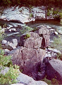
Big Spring Conservation Area
Van Buren. HWY RT 103. 573-323-4236.
Over 200 million gallons of water flow from this spring each day. Trails lead in and around the spring natural area, bluffs and cliffs.
Peck Ranch
Hwy H, Winona. Northwest Carter County and eastern Shannon County. 573-323-4249.
The 23,048 acres of rugged hills and hollows. Stegall Mountain is the highest point at 1,348 feet in elevation. Eleven miles of the Ozark Trail winds through the area, connecting trails through the Ozark National Scenic Riverways and the Mark Twain National Forest. Rogers Creek an Mill Creek flow through the area on the way to the Current River.
There is a 1/2 mile trail, near the headquarters, provides opportunites to see granite glades, wildflower savannas, beaver ponds, oak and pine forests. Habitat for pileated woodpeckers, turkey, hawks, deer, beaver, lizards, bobcat and black bear.
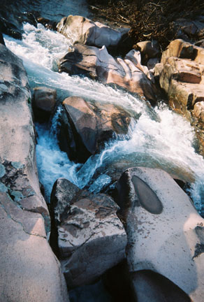
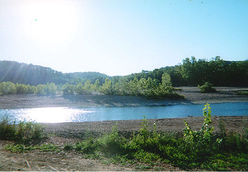
Ozark National Scenic Riverways
Shannon/Dent Counties. Van Buren. 573-323-4236
Missouris largest National Park Service area. 134 miles of the Current and Jacks Fork Rivers. Offers fishing,
canoeing, hiking, camping, hiking.
 The Current River is the most spring fed of the Ozark rivers. There are numerous springs and caves. The river can be floated year round, three hours to seven days.
Jacks Fork River is a 44 mile long narrow winding stream flowing through a deep vallley, nearly a canyon in its scenic beauty. The Upper Jack Forks River section is from the Prongs to Alley Spring, and is the most primitive part of the river. The Alley Spring section of the river is floatable until early June, before low water conditions.
Return to Top
Eleven Point Scenic River
Greer Spring at HWY 19. Riverton Access at HWY 160. and HWY 142 Access.
District Ranger, U.S. Forest Service, 1104 Walnut. Doniphan, Missouri 63935. 573-996-2153.
The Eleven Point River flows through the picturesque Ozark hills of southern Missouri. Its course is in view of steep bluffs and through sloping forested valleys. The river gains considerable width and depth as it proceeds southeastward. Springs pouring from dolomite bluffs or rushing up from an underground water systems provide a continuous source of water and beauty. Scenic sights include stretches of rapids and deep clear pools winding around moss covered boulders and shading bottomland hardwood trees. In some places, the canopy of green closes overhead.
Eleven Point Scenic River, one of America's rivers has been recognized and loved for its rich history and outstanding scenic beauty since early settlement days. In 1968, a 44-mile portion of the Eleven Point, between Thomasville, Missouri, and the Highway 142 Bridge, free of impoundments and with an undeveloped shoreline qualified as a National Scenic River.
There are many river floats to choose from, 36 miles, 2 to 3 days, or 7.5 miles. When floating on the river there are many highlights, features and float camps, Greer Springs Trail These highlights include the many Shoals and Springs, Horeshoe Bend in the river, Devils Backbone, onward to Blue Spring Hole, Devils Shute and The Narrows. Sights featured are Turners Mill, Whites Caves, Freeman Bluff, and Pine Bluff. Continuing to float the river, it will carry you into Arkansas.
Return to Top
Red Maple Pond Natural Area
Doniphan. US HWY 160 to JCT. C. North for 10.3 miles to Forest Road 4912, turn Right. 314-996-2153.
An unsual sinkhole holding water surrounded by a a canopy of Red Maple trees in the flooplain. The Red Maple Pond is a pond swamp containing two-feet high hummocks of which a variety of plants grow. The moist area is favorable for growth of azaelas, manna grass, lizard tails, royal fern and other rare flora, in season. The wildlife at the sinkhole Red Maple Pond include deer drinking, and as a habitat for amphibians.
Irish Wilderness
HWY 160 to State HWY J then north to White Creeks Trail, 7 miles. or US HWY 60 to HWY J to Camp Five Pond. Doniphan Ranger District, USGS. 573-996-2153.
The Irish Wilderness is 16,500 acres of lush woodlands, characterized by the steep landscape, featuring sinkholes, streams and caves. Many outdoor enthusiasts seek the peace and to experience the closeness to wilderness in the wonders of nature. There are many opportunities for primitive outdoor recreation. Elevations range to less than 500 feet near the Eleven Point River to over 900 feet near Camp Five Pond. Whites Creek Cave is a spacious walk in cavern containg crystalline formations, it is 1,600 feet in length. Whites Creek flows throughout the Irish Wilderness. The park is bordered by the Eleven Point National Scenic River on the west.
The Irish Wilderness is a dense growth of Oak-Hickory forest and scattered native shortleaf pine. There is an abundance of ground leaf vegation, smaller trees, flowering dogwood, persimmion, and sassafrass, shrubs, grasses and herbacious plants. Along the Eleven Point there are Black Walnut and other hardwoods. Wildlife along the Eleven Point River include blue and green heron, rattlesnakes, copperheads and owls, hawks, and woodpeckers and other song birds. Animal life in the wilderness, typical of Missouri Ozaarks, include deer, coyote, bobcat, and gray fox.
White Creeks Trail is 18.6 miles, the main trail within the wilderness. This steep trail travels through creekbeds, grasslands, glades, the steep limestone bluffs and breathtaking views overlooking the Eleven Point River. A good 2-day hike. There are various shorter within trails of the north and south loops, from each, the destination is to the White Creek float camp.
Scenic attractions include Fiddler and Bass Springs, and Brawley Pond all cool and refreshing waterways. Whites Creek Cave and other caves, and the beautiful and peaceful, yet challenging Eleven Point Scenic River.
Be prepared and its best to bring a map and compass. Pack Out What You Pack In!
Return to Top