In between L.A's first real rain of the year, Marshall opened a brief window this Saturday which made the waiting worthwhile, pointed the way forward, and hopefully bodes well for the season. I had the opportunity to fly a portion of a route which I had been planning for a long time-[but laziness and circumstance had prevented]. A few people have paraglided the length of the San Gabriels before to Kagel, normally starting from Cucamonga. The slight Southeaster this Saturday made a tough transition from The San Bernardino Range across the Cajon Pass slightly easier. The Cajon can get pretty windy, in fact it normally howls, as skybobo Ben found out in his trip to L.A. ;-] Its also fully wired with the I15 interstate, the railways and enough power lines to light Vegas. Not fun to land in going backwards...
The morning dawned looking good- without a trace of the thick high cirrus that would later shut everything down. I launched somewhat late at 1.00 p.m.,

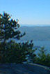
[Snapped these flying saucers before take-off. Perfect wave clouds geometrically spaced.]
...with a few PG's in the air. As soon as I saw Rob McKenzie on a Hang about 1/4 mile west of Cloud Peak screaming skyward at a massive bank angle, I knew the air was doing what it promised. Strange air at times, but stuff was going up so I set off quickly, racing against the sun now as cirrus was moving in. A few hundred feet at Marshall, just enough to get me to Cloud where I hooked a decent climb out. Deciding against going to Billboard as usual, I got into race mode and chased off to Pine Mountain, where a pretty strong climb got me up to a few thousand over, drifting me back westerly before breaking up fairly violently. It didn't make sense to hang around, so I took advantage of the quartering tailwind and decided to try my luck with the foothills around Devore Parkway. If I could get up on those and get established in the San Gabriels, Pasadena or even Kagel would be possible with the daylight left. Working some decent lift got me through the foothills, where I got low in the lee getting around the corner. Getting round the corner in the hills by Devore Parkway was the hardest part of the flight, a process of a rough, scrappy climb, then full bar while getting drilled heading to the next hill. Then Repeat.
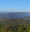
Slow and tedious going, and it often seemed like I was down, but I stuck at it and eventually battled through the venturi arund the corner and back into the main SE flow. The times I've been here before, the prevailing Westerly has always howled through the gaps, halting progress. It wasn't as bad on this day and I was pleased to sniff out a great climb from deep in a canyon. Drifting west now and working the thermal for over 6000 feet, this got me back in business and well established on Cucamonga,

...stunning with its blanket of snow contrasted against the pastels of the desert beyond.


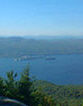
The crystal clear air made for some amazing views back to Crestline and the desert. But now my attention was focussed west, and the outline of downtown L.A. beckoned me on. The next climb was off a spur right in front of Cucamonga- getting stronger at last at 1300 {6.5m/s} up on the averager and peaking off the vario. Downwind glides were good, jumping spines,

...and racing low to save time now that the day was threatening to shut down. A better day would have favored commiting to the heart of the San Gabriels and Mt. Baldy,

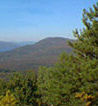
...if one were fairly sure to get back out at the end of the day. The Angeles National Forest was a stunning green and California gold, even in the gathering gloom, with snow down to about the 6000 ft level. Faced with a similar situation, I think someone well {warmly} equipped for survival and willing to land waaaay out could take this faster, higher route. I contented myself with snapping off some photos and headed on. I kept on trucking along the front range though- now over Mt. Baldy road and with my college baseball field in easy glide.

Here I thought about a trip over the city but my suspicion that there was a baseball game on was later verified. Oh, well, who needs poser appeal when there's distance to be had? Getting lower by the radio towers North-east of Claremont, I bobbed along in lighter and lighter lift, the sky completely shutting down from the high cloud. Only 3.p.m., with plenty of daylight left to get around the corner to Pasadena and the San Fernando Valley, which seemed only a couple of good climbs away. Damn, damn....Only two hours in the air, but 50 k.m.'s on the clock. Piecing the patches of sunlight together got harder and harder until the sky closed up totally just after 3 p.m. I hugged the ridges just getting mileage as I sank lower and lower in the Canyons above Glendora, before getting drilled leeside just into Azusa. Landing was interesting- a long, low, pointy toed glide through the sink {the Bagheera always amazes me with its glide} into the only available bit of non-bushy ground. Flew straight and flared hard for a nice fly-on-the-wall landing on a tiny embankment. Not having to pick glider out of bushes was a deep satisfaction, but not being able to press on left me hungry for more. But it was clear what would be possible, and I hope to head out this way in future. I saw a good looking launch site above Glendora that would take the tricky Cajon Pass out of the equation altogether, and allow big, easy flying both directions. Any big distance will have to wait for next time...
Map with Landing Marked. [Takeoff north of San Bernardino,just to the right of the "215" Crest]

** Home ** France ** Copine ** Mexico ** Reviews **