

(1980-July 1, 2003)
[Old] WEST End (1983-86): Intersection, IA 297, Raymond, Black Hawk County
Facing west on 939
As the US 20 freeway worked westward, 939 was given its old route. The Waterloo Courier waxed slightly poetic upon completion of I-380 to this point, the first interchange with 20 heading west, in 1983, speaking of the glimmer of the freeway on the horizon.
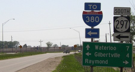
West of this point, old 20 is not signed as D22. This might be because the route to the west was turned over to the county and cities in 1984, separately from the segment east of 297, which was turned over in 1986. The 297 shields came down in summer 2003, so this intersection now only has county shields plus assorted "To I-380"s.
WEST End (1986-July 1, 2003): Intersection, V62, Jesup, Black Hawk/Buchanan county line

Facing west on 939 (May 2003)

Closeup of sign (January 2002)
Photo by Jason Hancock
Highway V62 straddles the county line; D22 continuing west of here also straddles a small east-west portion of the line.

Facing west on 939
This picture, a few dozen feet back from the "End" sign, shows a curve going north into Jesup, a remnant of an "ancient" alignment of 20 using what is now D20 and IA 281 going in a straight line west to Waterloo on Independence Avenue (so named because it went to Independence, most likely).

Facing east on 939
[Old] WEST End (1980-1983?): East city limits of Independence, Buchanan County
In 1976, the freeway was completed between IA 187 and IA 150. Between then and 1980, when 939 was offically designated, neither Jason nor I am sure of what the old route was designated. We do know that Independence took over its segment early, even though 939 was signed through town up until 2003.
West limits: Old IA 248

Facing west on 939 (old 20)
This picture was taken when I thought this might be either the west end of the break in 939 or the west end of the route in 1981 or 1982 when an additional portion of 20 was opened, between 150 and the west Independence interchange. The 1981 map notes the segment should be open 'Late 1981', but a 1982 topographical map shows it as still under construction, so we don't know. The city limits on both sides of Independence were extended, which is why Independence received a fraction of a mile on both ends when 939 was decommissioned.
Junction IA 150/East end of 939(?)

Facing west on 939
In downtown Independence, 20 shared a very small distance with 150. At the next light in the background, 150 goes south.

Facing south on 150
The really short duplex of 150 and 939 did not allow for signage along the route, so this is the best I could do. This is in downtown Independence, where 939 is signed but not officially part of the route. Today, D22 is signed through town.
EAST End: Stop sign, IA 187, Buchanan County

Facing east on 939 - January 2002
Photo by Jason Hancock

Facing east on 939 - December 2004
I think this is the first time that a bracket has been altered in a way other than signs disappearing between visits to ends. The most plausible explanation is that in 2002 or early 2003 this was put up with an "End 939" on the right.

Facing south on 187 - January 2002
Photo by Jason Hancock
This intersection has been reconfigured since it was the south end of 187 at 20; now the east-west traffic stops. The freeway ended here until the late 1970s; the 1974 map shows a four-lane stretch of 20 (although not marked as such) between 187 and 13. The 20-187 interchange is visible on the left side of the picture. This assembly has been replaced with one pole and a "Jct D22 <->" (see below).

Facing south on 187 - December 2004

LGS cropped out of above picture
Really, since it's less than a mile, the "1" shouldn't even be on the top line.
Last seen: 2003

Pictures by Jason Hancock: Third, ninth, and eleventh, 1/26/02
Pictures by me: First, second, and fourth-eighth, 5/20/03; tenth, twelfth, and thirteenth, 12/14/04
Page created 5/7/02; last updated 1/4/05
