

NORTH End: Minnesota state line, on I-35, Worth County IA/Freeborn County MN

Facing north on 27(/35)
This is not the northernmost IA 27 shield; instead, it is the first one solely paired with I-35 near Clear Lake. All the 35/27 assemblies in Cerro Gordo and Worth counties are like this. This point, just north of the US 18/IA 122 interchange, is where I would have put up a green sign on the interstate reading "27 Ends / Avenue of the Saints / Continue on I-35" instead of continuing the redundant duplex to the state line. If they had wanted to make the avenue fit into the interstate system, the obvious number would be 37, but this was not done because of the existence of IA 37 in the western part of the state.

Facing north on 27

View of same from southbound lanes; "Welcome to Iowa" at far left


Closeup of signs at Minnesota line

Facing north on 35
This view of Minnesota is from the bridge on State Line Road. The "Welcome to Iowa" side is actually on this, the north side, of the bridge, to the left of the No U-Turn sign (see below).

Facing south on 27
Turn around on the bridge and you see the interstate's entry into Iowa. At far right are the Eisenhower Interstate System and Worth County signs. At center right are the first shields in Iowa. At center is one Minnesota-style official-vehicle turnaround.

Facing south on 35, Minnesota side of the bridge

Facing south on 27
In summer 2001, the Iowa DOT began to mark the route of the Avenue of the Saints as IA 27, since the avenue follows different highways - IA 394, US 218, I-380, US 20, IA 58, US 218 (again), US 18, and I-35. About 272 miles after seeing the shields above, southbound IA 27 drivers will encounter the following gantry:
Split with US 218

Facing south on 218/27
Ten miles north of the Missouri line, US 218 and IA 27 join/split for the first/last time. In an Iowa highway first, "Former 394" was added to signs at the interchange near 394's old north end. This sign is a bit misleading, because while 27 is the mainline, numbering for 218 should take precedence. As it is, 218 is exiting from itself with its own exit number; I suggest either moving "Exit 18" to the left sign or getting rid of it. (I know this isn't the best picture, but facing south three days before the winter solstice doesn't make a good one possible.)

Facing north on 27
Here's a good view of the opposite direction. Notice the difference in exit numbers, and the right-aligned exit tab in the background. Additional pictures of this area throughout the decade, including the current view of this interchange from the cross road, can be seen on the IA 394 North page.

Facing east on J62
Here's a rare sight: A "Jct 27" without another shield beside it. This is about two miles south of the interchange with 218. Right behind the camera is the old IA 394 two-lane; the four-lane deviates from it north (left) of here and also at Argyle.
Old SOUTH End: Toll bridge, Missouri state line, St. Francisville MO, Lee County IA/Clark County MO
On May 23, 2006, the entire route of IA 27 opened to four lanes. Originally, IA 27 ended as a two-lane road with IA 394 at an old toll bridge into Missouri. Ironically, on April 14, 1937, the Iowa Highway Commission said it did not "see its way clear to request" a federal-aid road running due south from US 161 (now 218) to St. Francisville; 70 years later, it's part of a major four-lane corridor.
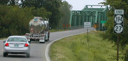

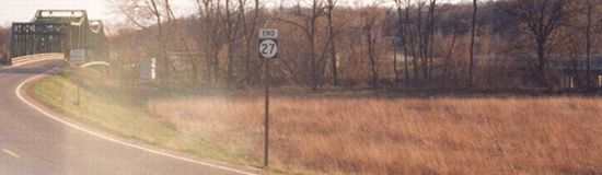
Facing south on 27/394
Photos by Neil Bratney
To my recollection, the End sign was not posted in March 2002. Jason Hancock's visit in April 2004 confirmed the disappearance of 394 as a signed route.
Facing south on 27 with new bridge visible at far right
Photo by Jason Hancock
As planned for the freeway, 27 became the only number on what was 394, and 218 itself will go down to its current two-lane diagonal to its end at US 136 in Keokuk - creating a very visible gap in Iowa's expressway system with two north-south four-lanes having no similar connection between them at their closest point.

Facing north
Photo by Jason Hancock
At the end of 2004, the toll booth in Missouri was closed because the four-lane bridge had opened, but the toll bridge itself was still driveable. It likely will be torn down in the future.
SOUTH End: Missouri state line, St. Francisville MO, Lee County IA/Clark County MO

Facing south on 27
Photo by Jason Hancock

Facing north on 27, Missouri side
Photo by Jason Hancock

Facing north on 27
Photo by Jason Hancock

Facing north on 27
Photo by Jason Hancock
At the end of 2004, the four-lane ended half a mile north of the state line.

Facing north on 27 (now with welcome sign, compare to 2004 two pictures up)
Photo by Jason Hancock

Facing south on MO 27
Photo by Jason Hancock
The first MO 27 sign is at the junction with Highway B, which was realigned to the west of St. Francisville (instead of going through town and ending at the toll bridge). There is one interchange with US 136 at Wayland, and then 27 ends at US 61.
SOUTH End of MO 27: Intersection, US 61, Clark County MO

Facing south on 27
Photo by Jason Hancock
Jason writes, "The four-lane MO 27 ends about a mile north of its south end, and 27 joins the alignment of the former US 136 spur."

Facing south on 27
Photo by Jason Hancock
After being in Missouri for about 7½ miles, you can go right back into Iowa.

Facing south on 27
Photo by Jason Hancock
This is the north end of the intersection with US 61; there is a dominant NB-EB curve. (If the curve is the hypotenuse, this intersection is the right angle.) The 27 designation ends as it hits the Avenue of the Saints' last route (unlike a certain other state's...) as the connection continues south on 61.
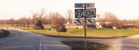
Facing north on 61 (April 2004)
Photo by Jason Hancock
In December 2001, the shield at left was IA 394. My picture of the same assembly at that time is on the IA 394 South page. More photos of the area are on Jason's Avenue of the Saints page.

Same assembly (December 2004)
Photo by Jason Hancock
Despite the break in the former spur, and despite the fact that this road has its own number now, this sign tries to insist that 136 and 27 share the road. In reality, a "To" needs to be on top of or in place of the "West".

Facing west on "61" (short access road to 27)
Photo by Jason Hancock
"End 27" is at far right.
Pictures by Neil Bratney: 13th and 14th, 6/5/02
Pictures by Jason Hancock: 15th and 26th, 4/4/04; 16th-20th, 22nd-25th, 27th, and 28th, 12/24/04; 21st, 6/30/06
Pictures by me: First, second, fourth, and fifth, 3/19/07; third and sixth-ninth, 5/17/04; tenth-twelfth, 12/18/06
Page created 5/31/02; last updated 4/15/07
