back The Rise of Early Civilisations

The first civilisations grew up along the banks of rivers. This is because the rivers provided water for irrigation of their crops and water for their domesticated animals. They now had more food and no longer needed to be nomadic wandering tribes.
They now had enough food so that they did not all need to spend their time hunting. This let people specialise in different skills they were interested in and good at, such as healing, art, music, building, making tools or furniture, building boats, trading, etc.-These are all of the different things we find in a civilisation.
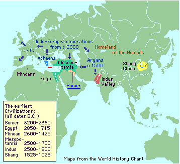
Print off this blank map of the earliest civilisations. Paste it in your book, label it and colour in the key correctly. Use the information provided in the following map.
The
Early
civilizations
(from http://www.hyperhistory.com/online_n2/maptext_n2/maptext.html)
A.
Mesopotamia -
Located around the
the Tigris -
Euphrates Rivers.
(The
Fertile Crescent)
One of the problems though
facing early civilizations was setting up laws to govern themselves
once people started living in communities instead of hunting, gathering,
and roaming for food.
By the early fourth millennium B.C., the population around the Tigris - Euphrates rivers increased; and city-states arose. By 2000 BC the cities of Sumer had grown so large that some like Ur, the capital city, had populations more than 200,000 persons. (1 millennium = 1,ooo years )
The Priest King Hammurabi (c. 1792 - 1750 BC) united all of Mesopotamia under his forty-three year reign of Babylon. Although Hammurabi's Code is not the first code of laws (the first records date four centuries earlier), it is the best preserved legal document reflecting the social structure of Babylon during Hammurabi's rule.
About the Code Two hundred eighty-two laws, concerning a wide variety of abuses, justify Hammurabi's claim of having acted "like a real father to his people . . . [who] has established prosperity . . . and (gave) good government to the land."
See for Yourself The laws were discovered in 1901 on a stela now in the Louvre Museum of Paris, France. (See below)
The first writings, that appeared about 3000 B.C. in
the Sumer civilization (with the cuneiform scriptures), in the
Middle East, were accounting records. They recorded the number of
cows owned by some rich people, or the quantity of wheat purchased by the
king etc. The other early writings were law codes and epics.
Geographically Sumer was located exactly where is today Southern
Iraq.
 cuneiform writing
 cuneiform writing tablet
1. Put this heading in your book on a new page: 'The
Rise of Early River Civilisations'
2. Answer this question in a
complete sentence: Why did the first civilisations grow up along the banks
of a large river?
3. Write five main points in your book about
the Priest King
Hammurabi.
4. Copy or draw one line of the cuneiform writing
from the artefact above, and label it .
5. Open, print off and paste in
your book this
blank map of the early Nile, and Tigris and Euphrates River
civilisation.
Then label and colour the blank map in your
book. Get the information from the map
below.


Geographic location of
Sumer
a stela
B. The Indus Valley Civilisation - Located around the the Indus River (Pakistan)
1. Open the following site and go on the tour of the ancient river civilisation around the Indus valley. http://www.bbc.co.uk/schools/indusvalley/
2. On a new page make up a mind map about the Indus
civilisation. Start by writing the heading: The Indus Civilisation in a
4cm circle in the middle of a new page.
(To see how to make an
interesting mind map, type 'mind maps' in a 'Google'
'Image' Search.)
3. Print off the following blank map of the Indus River valley and paste it in your book.
Open this link and study the map of the Indus Valley. Use this detailed map and the maps shown above in the adventure tour, to label the blank map you stuck in your book.
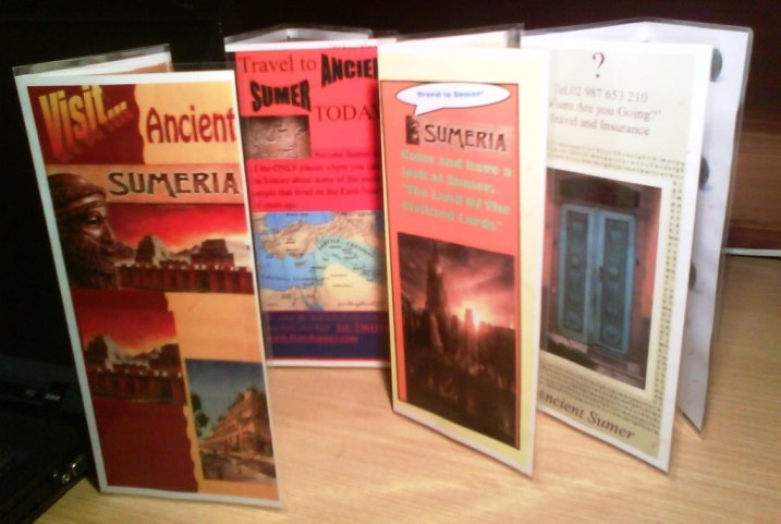
4. Optional extension activity: Do a Google/
image search, to find some interesting sites that give information about
Sumer. Design a travel brochure that encourages
tourists to visit Ancient Sumer. You could use
Microsoft Publisher (No.13)
to make a brochure. Examples of
student work
You could use the two following web sites as well,
to find information for your brochure:
http://www.ancientmesopotamians.com/index.html
http://www.historywiz.com/exhibits/royaltombsofur.html
You could use pictures from this
image gallery to illustrate your
brochure.
Aspects of ancient Sumer that you could highlight are:
Their beautiful architecture, their food, accommodation housing, jewellery
they sell, the clothing, their safe society because of their great system of
law and order, transport, military displays, musicians, their cute cuniform
writing!,their markets and games.......
When you have finished this task, you can play
this
ancient Sumerian royal game!
www.interactive-learning.com.au