
|
Map of Malaga Creek & Cove Area 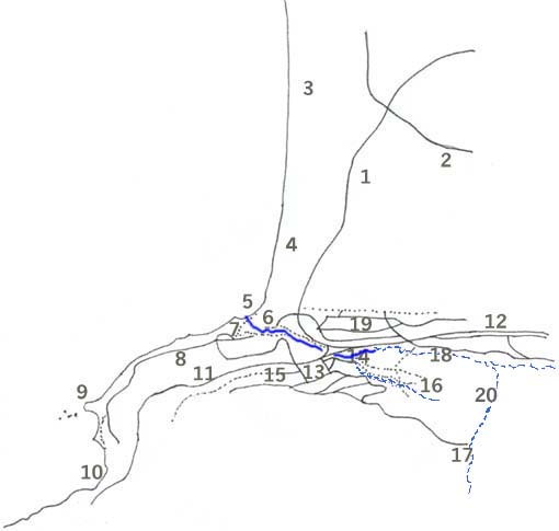 © Mitch Heindel, 2003 |
| 1 - Palos Verdes Boulevard | 8 - Paseo del Mar | 14 - via Tejon Trailhead | ||
| 2 - Pacific Coast Highway | 9 - Flat Rock Pt. | 15 - Tejon Place-fire trail | ||
| 3 - Redondo Beach | 10 - Bluff Cove | 16 - Giant Ancient Sand Dune | ||
| 4 - Torrance Beach | 11 - P.V. Dr. West | 17 - Upper Malaga Canyon | ||
| 5 - Malaga Cove | 12 - P.V. Dr. North | 18 - Paseo del Campo | ||
| 6 - Creek "behind the church" | 13 - Neptune & Plaza | 19 - La Selva-"North Forest" | ||
| 7 - Cove Overlook & Creek Mouth | 20 - P.V. Country Club |
|
Solid Blue is permanently running water. Dashed Blue is usually dry creekbed. Scale: It's about 1 mile from Malaga Cove to Flat Rock Point. |
(Closing this window to returns you to Malaga Area Page.)
|
This page is printable with some browsers,
such as Explorer ... Netscape browsers may not print the map. In this case, you may right click the map to save the picture, then open the file you saved while in your browser and print the map separately. |
