The Art of Peace is a celebration of the bonding of heaven, earth, and humankind. It is all that is true, good, and beautiful.
~ Morihei Ueshiba
Big Sur Country stretches from Yankee Point on the north to Ragged Point in the south, 70 miles of rugged California Coastline.
Bella Vista is located south of Carmel between Garrapata and Andrew Molera State Parks, California USA.
Here's a website with the Highway One Mile Markers from Carmel to SLO/Monterey County line (great to print out for your travels) ~ Highway One Mile Markers
Open Google maps then copy & paste this:
Highway 1/Palo Colorado Road, Carmel, CA
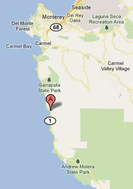
"A" is the junction of Highway 1 and Palo Colorado Road.
Location, location, location.
DIRECTIONS: Palo Colorado Road wanders up through a classic Coastal Redwood canyon. This canyon offers a rare drive that follows the creek. Take your time and enjoy something special. After two miles turn left at the fire station, drive 500 yards on a dirt road up to Bella Vista.
The Big Sur Coast often gets summer fog. Bella Vista sits on a five-acre hillside at 1200 feet. This puts Bella Vista high enough to be above the summer fog on most days. The summer fog may roll in, usually in the evening, creating a gorgeous landscape and cooling the heat of day.
Bella Vista makes a great base camp or retreat. It's easy to make daytrips then drive home to Bella Vista and watch the sunset. Or stay put and indulge in time-out retreat mode. All day is Hammock Time. The house offers a full kitchen with a view and basic pantry items are supplied. Bring some groceries and eat the food you love.
The property is quiet, peaceful, beautiful, relaxing, surrounded by nature, soothing and very comfortable. At night, it's special to turn off the house lights, sit outside on the deck, watch the stars and listen to the night. No city lights here. Plan around the phase of the moon.
Dawn and dusk often bring deer, quail and the occasional bobcat.
It's a wonderful spot to enjoy nature in comfort.
0.3 mile/mile marker 62 Rocky Point Restaurant ~ Spectacular view
mile marker 62.5 Abalone Cove Vista Point
1.6 mile/mile marker 63 Garrapata Beach in Garrapata State Park
4.2 mile/mile marker 65.8 Soberanes Point Redwood Canyon in Garrapata State Park
4.4 mile/mile marker 66.0 Soberanes Rocky Ridge Trail in Garrapata State Park ~
steep & strenuous with an awesome view
8.1 mile/mile marker 69.4 Carmel Highlands General Store & Gas Station
8.8 mile/mile marker 70.2 Point Lobos State Nature Reserve ~ Gorgeous easy walks.
mile marker 71.0 Carmel River State Beach (south access ~ Monastery Beach)
mile marker 72.33 Carmel River Bridge
11.4 mile: Carmel-by-the-Sea
17.4 mile: Monterey Bay Aquarium
SOUTH of Palo Colorado Road/Highway 1:
1.5 mile/mile marker 60.1 Rocky Creek Bridge 1932
2.0 mile/mile marker 59.8 Bixby Creek Bridge 1932
2.0 mile/mile marker 59.8 Old Coast Road ~ 10-mile dirt road used until Bixby Creek Bridge was built
2.5 mile/mile marker 59.3 Brazil Ranch Trail trailhead. Climb from Highway One to 1400 feet.
7.6 mile/mile marker 54.1 Point Sur State Historic Park & Lighthouse [ note: when this link opens in the browser, click address twice ~ http://www.pointsur.org ]
10.7 mile/mile marker 51.2 Andrew Molera State Park
15.4 mile/mile marker 46.9 Pfeiffer State Park
mile marker 45.64 Sycamore Canyon Road (to Pfeiffer Beach)
mile marker 43.1 Deetjen's Inn/Restaurant