Home
Chase Day Outlooks
DAY 2
DAY 3
Forecast Links
NCAR/RAP
NexLab Analysis
SPC Meso Analysis
Stormtrack Data
TESSA - Tornado Alley
WeatherTap
IWIN
Texas
Oklahoma
Kansas
Missouri
Arkansas
Nebraska
Colorado
Iowa
Surface Data
Southern Plains
Overlay Map
Central Plains
Overlay Map
Upper Air Data
Rawinsonde Plot at:
200mb
250mb
300mb
500mb
700mb
850mb
With Contours:
200mb
250mb
300mb
500mb
700mb
850mb
Radars
Fort Worth, TX
Dyess AFB Abilene,TX
San Angelo,TX
Midland,TX
Lubbock,TX
Amarillo,TX
Frederick,OK
Oklahoma City,OK
Wichita,KS
Satellite
NCAR-RAP SATELLITE
Chase Logs
2003
2002
2001
2000
1999
Stormchase Links
Stormtrack
Storm Prediction Center
Weather Graphics
Tessa
SPC Meso Analysis
|
TODAY
Valid:
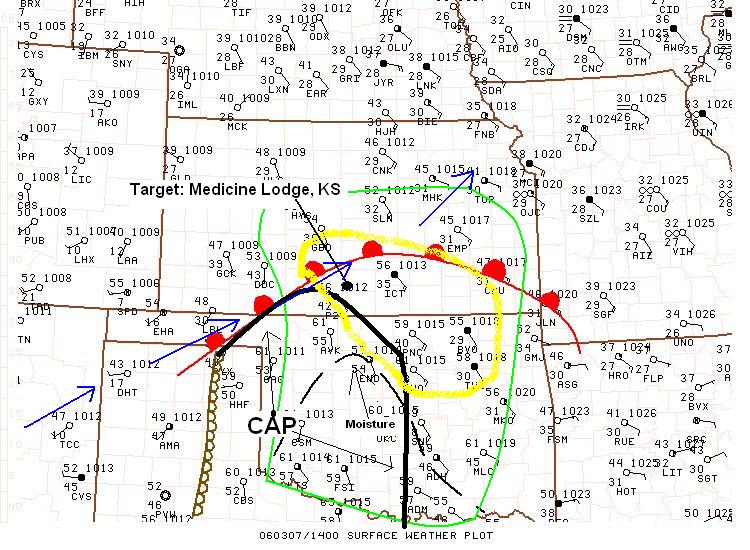
MARCH 7TH, 2006
FORECAST:
--- FIRST CHANCE OF CHASABLE STORMS FOR THE 2006 SEASON, SOUTHERN KS - NORTHEN OK.
Warm, moist surface air moving northward today from TX to KS ahead of an approaching system from the west. Dryline will move into western OK and SW KS down to West Central TX by late this afternoon. The very strong cap in place today will be a major negative factor in the storm development today, especially south of I-40. Storms will fire late this afternoon in southern KS and become severe. CAPE will be near 2000j/kg in this area. Supercells are possible with an isolated tornado near the KS, OK border.
TARGET:
Medicine Lodge, KS
Rawinsonde Data


|

