
For additions and updates, email David Wood
Maddron Bald Trail to Greenbriar Cove-15.8 miles
An exceptionally long course traversing several watersheds. Although the trail is never steep, it continuously climbs up and down to accumulate a substantial gross change in elevation. Allow 7.0 hours to the Ramsay Prong Road in Greenbriar Cove.
Elevation gain: 400 feet
Maximum Elevation: 3,200 feet
Quad maps: Jones Cove 163-SE
Mount Guyot 165-NE
Mount Le Conte 165-NW
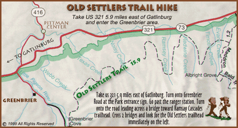
Point of departure: From Gatlinburg drive east on US 321 about 15 miles to Laurel Spring Road, just west of the Yogi Bear Jellystone Park Camp Resort. The Maddron Bald Trail is 0.2 miles along the Laurel Spring Road. To park at the trailhead, drive a mile farther west on US 321 to Baxter Road, turn right, circle around to Laurel Spring Road, and approach the trailhead from the east. On the approach, look for a very sharp turn onto the unmarked Laurel Spring Road. Hike 1.2 miles on the Maddron Bald Trail. The Old settlers Trail leads right 15.8 miles to Greenbriar Cove. Gabes Mountain Trail leads left t 6.7 miles to Cosby Cove.
0.0--Maddron Bald Trail leads right 1.2 miles to the Laurel Spring Road, and left 1.7 miles to Albright Grove. Gabes Mountain Trail leads directly away 6.7 miles to Cosby Cove.
0.6--Indian Camp Creek
2.1--Snag Mountain
2.3--Road descending Webb Creek
3.2--Road leading right to Tyson McCarter Barn. Old Settlers Trail crosses creek.
4.1--Junction at Texas Creek. Access trail leads right to Hwy US 321.
6.8--Junction at Noisy Creek. Access trail leads right to US 321.
9.2--Settlers Camp Backcountry Camsite (33)
9.3--Standing chimney and log crib. Access trail leads right to US 321 near Wa-floy Retreat.
10.7--Access trail leads right to US 321 near Steiner-Bell Resort.
15.8--Ramsey Prong Road
High on the rugged northern face of Greenbrier Pinnacle, tiny rills collect in narrow defiles, forming small streams that rush hurriedly down from the high country. By the time these streams reach the lower elevations, they have names, including Indian Camp, Dunn, Webb, Texas, Noisy, Ramsey, Redwine, Timothy, Soak Ash, Snakefeeder, and Little Bird. In the mid-1800`s, pioneer settlers moving south into the Pinnacle low country began working up these creeks, settling along the narrow bottoms by the streams. Here they built log cabins and barns, planted crops and orchards, raised cattle, and endeavored with an indomitible spirit to wrest a living from the stony soil.
Along with the cabins and barns, the settlers built roads, dirt byways that meandered up the bottomlands, usually stopping at the last house up the creek. Though there were a few exceptions, these settlement roads did not stray far from the creek and rarely crossed over a ridge and into the adjacent valley. Several years ago the Park Service rehabilitated portions of these old settlement roads and connected them with new graded trails across the ridges. These old roads and the graded trails now make up the Old Settlers Trail, a long course that extends from the Maddron Bald Trail to Greenbrier Cove.
The Old Settlers Trail begins along the Maddron Bald Trail just opposite the Gabes Mountain Trailhead. Almost immediately it drops into an old roadbed and passes through an abandoned settlement marked by a collapsed chimney, short sections of stone fencing, and odd piles of rocks. In clearing the bottomland for cultivation, the settlers found an overabundance of rocks. Many of these rocks found their way into miscellaneous heaps at the sides of fields to get them out of the way.
About a half mile below the trailhead, the Old Settlers Trail crosses Indian Camp Creek on a footlog discretely positioned about fifty feet below the point where the trail meets the creek. Immediately thereafter it passes through more old settlements as it proceeds to Dunn Creek. Beyond Dunn Creek the trail starts up and around Snag Mountain, affording glimpses of Gabes Mountain on the way up and Greenbrier Pinnacle on the way down the other side.
The next stream is a small tributary of Webb Creek. Just beyond it, the trail passes through a clearing to intersect another settlement road. To the left is an old hog pen that resembles a corn crib. Here the trail turns right to follow the road downhill. Stone walls stand along both sides of the creek, and to the right are several large plots marked off by stone fences.

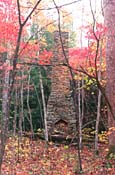
At the Webb Creek crossing the trail appears to intersect another old road running perpindicular to the creek. As the trail turns left to cross the creek, it enters this second road. To the right, the road leads to the Tyson McCarter Barn. One hundred yards down the road is another intersection. A left turn here leads fifteen yards to a wide right-hand curve in the road. Fifty yards beyond the curve, and east, is the barn, a small, double-cantilevered structure estimated to have been built in 1876. This is the only large building on the Old Settlers Trail maintained by the Park Service as a historic structure.
The old road approaches the building from the left back, from where it resembles a conventional barn. Closer inspection reveals that the back overhang has been enclosed with light, horizontally placed timbers, disguising the cantilever. A small, stable-like lean-to and a pigsty are appended to one side of the barn and a large corn crib stands in front. A few yards beyond the barn is the old McCarter homesite, a remarkably flat and unusually pretty clearing that harbours a spring house and two standing chimneys from the former cabin.
If you visit the cabin, walk back (west) to the Old Road to a curve, A stone wall ends there. There is also an access trail (running north to south) which leads right, in the curve, to a small parking lot on Hwy.321 in which you can park and start here as well. At the curve, there is an Old Settler Trail sign, with arrows pointing west, which continues the Old Settler Trail. The Old Settler Trail soon crosses Webb Creek and follows down a country lane leading into the Texas Creek watershed. Both sides of the land are lined with stone walls. The walls on the left is quite impressive. It stands nearly six feet high and almost half as wide.
****Note: At the end of the large rock wall, which is running parallel to the Old Settlers Trail, and on the left (west), there is another large rock wall, next to small stream crossing. Leave old settlers trail and follow stream south (upstream) and parallel to the large rock wall. This wall runs north to south. Hike upstream approximately 1/4 mile on the left side of the creek. There is a number two wash pan, and the bottom is rusted out, and placed over a small tree, at the creek bed edge. There is also a yellow ribbon tied to a branch. To the west (right) is a small mountain that has a round top. At the top of the mountain, which is only about 75 yards, in distance traveled, from the creek, is the small cemetery. There are only 2 graves. Johnnie Ramsey and an infant. The cemetery contains what`s left of a fence and only one large, rounded, headstone. The infant stone hasn`t been located. The stone inscription reads Johnnie 4 July 1836-----23 July 1907. Also it reads, "He served faithfully to the end". The stone is in fine condition. A yellow ribbon was tied by Helen Ramsey King, Perry Ramsey`s daughter, to a tree branch at the cemetery, which is visible on your ascent up the mountain. It is steep climbing! Helen Ramsey King showed me the grave, and she is quite the hiker. Being off trail, she was very comfortable.
On descending to Texas Creek, the trail encounters an access spur leading out to US 321. The Old Settlers Trail turns here and follows a rough road upstream along Texas Creek through another string of abandoned settlements. The most interesting of these is a large ruin about one-quarter mile up the creek, and to the left of the trail. Two chimneys stand adjacent to each other near a surviving corner section of a cabin wall. In the mouth of one of the fireplaces is a lintel shaped like an inverted V. This peculiar design feature may have been employed for structural reasons, or it may have been added merely fo artistic flair. Regardless of its origin, the design is conspicuous in several of the chimneys along the the Old Settlers Trail.
High up, the trail crosses Texas Creek and ascends to its highest elevation on a slight ridge just west of the creek. On clearing the ridge, the trail descends quickly through a pocket of huge hemlocks, crosses Tumbling Creek, and enters a thinly wooded plot on Noisy Creek that was once a farm field. The trail continues descending, following another old roadbed through several more homesites, crossing Noisy Creek two times. After the second crossing, the trail turns away from the creek to pick up a graded trail leading over the ridge to Ramsey. Near this juncture a spur exits the Old Settlers Trail, descending along Noisy Creek to US 321.
After four or five crossings of Ramsey Creek, the trail approaches Redwine Creek, crossing it to arrive shortly at the Settlers Camp Backcountry Campsite (33). The site is to the left of the trail, behind a standing chimney. Camp may be pitched in the garden plot behind the homesite or in the thicket of spindly hemlocks at the edge of the field. The site is rarely used and exceptionally clean.
Just below the campsite, the trail passes between a standing chimney and a log crib once used perhaps as a pigsty or chicken coop. The crib is in very good condition. The chimney is another example of V-shaped lintel design found in homesites along Texas and Noisy Creeks. Below the ruins and near a bed of roses planted by the former owner, a rudimentary path leads to the right from the Old Settlers Trail one mile to US 321 near the Wa-floy Retreat.
Shortly, the trail leaves the bottoms and starts into a long, easy climb over Copeland Divide, first following Soak Ash Creek, then crossing a small ridge to Snakefeeder Branch. A half mile above Snakefeeder, the Old Settlers Trail crosses the spine of Copeland Divide, then eases slowly to the Little Bird Branch. On descending Copeland Divide, the trail affords glimpses of Greenbrier Pinnacle to the left, easily identified by its distinctive lines of barren cliffs.
The trail finishes with an easy excursion through wooded lowland, first a pleasant run along Little Bird Branch, then over to Bird Branch and across the wide bottoms to the Middle Prong of the Little Pigeon River. The Old Settlers trail terminates on the Ramsay Prong Road a few yards above the bridge crossing the river.
For questions and comments, e-mail David at dciris@eudoramail.com
