

Western Australia is the largest of the states. Perth the captial of Western Australia enjoys the best climate of any Australian capital with a mean temp of 23.5C in the hottest month, February and a mean temp of 13C in the coldest month of July.
In May 1829 Charles Fremantle, captain of the ship Challenger, took possession of the western part of Australia for Britain. On 1 June 1829 James Stirling arrived in the Parmelia with seventy settlers to found the Swan River Colony, which later became known as Perth. Western Australian's now celebrate the first Monday in June as their Foundation Day holiday. Although the state was founded by free settlers, Britain sent convicts there from 1850 to 1868 to help overcome a labour shortage. Many buildings, including Perth Town Hall, were built by convicts.
Western Australia did not gain responsible government until 1890. It was the last colony to do so. It was also the last colony to agree to join the Federation of States that eventually formed the Commonwealth of Australia in 1901.
The flag was adopted: circa 1953. This flag is a British Blue Ensign defaced with the state badge. The badge depicts the native Black Swan on a yellow disc, with the swan swimming towards the hoist. A variant to this design renders the swan more artistically and includes water ripples. The black swan has long been a symbol of Western Australia. The original colony was in fact called the Swan River Settlement, and in 1870 Governor Weld suggested that the black swan would be the obvious choice of badge for the colony - as it "has been always considered as its special badge, or cognizance." The total population of Western Australia is 1,461,700 in which the majority live in and around Perth, approx 1,193,100.

COAT of ARMSThe generally accepted symbols of Australia are golden wattle, the red kangaroo, and the emu.Although they are not officially proclaimed as national symbols, they feature in the Coat of Arms pictured.
The Coat of Arms of the State of Western Australia was granted by Her Majesty, Queen Elizabeth II, by Royal Warrant dated the 17th day of March, 1969.
For Arms: A silver shield with a base of rippled blue across which is a thin wavy silver stripe. A black swan, in natural colour, and in horizontal position is floating on the blue base which represents water.And for Crest: Resting on a gold and black wreath is the Royal Crown between two Kangaroo Paw flowers accurately depicted.
And for Supporters: Two red kangaroos support the shield held between them. A boomerang accurately depicted is held by each in their other forepaw.

FAUNAL EMBLEM (bird) of the State of Western Australia is the BLACK SWAN.The Black Swan was first recorded by the Dutch navigator Vlamingh in January 1697 in the Swan Estuary. Although it is to be found throughout Australia, this graceful bird has been regarded with special affection by many generations of Western Australians and has long been used to identify things Western Australian.
The plumage is black, often with a brownish tinge, but the flight quills are pure white and very prominent when the bird is seen in flight. The beak is red with a white band near the tip and the legs and feet are dark grey.

FLORAL EMBLEM of the State of Western Australia is THE RED and GREEN KANGAROO PAW.The Red and Green Kangaroo Paw was first collected in the Swan River Colony in the early years of its settlement, and was described by D. Don in 1836.
Western Australia's floral emblem is a flower shaped like a kangaroo's paw which emerges from a grassy tussock. The Red and Green Kangaroo Paw is striking for its metallic green, furry flowers and red stems. The flowering stems are between 30 - 120 centimeters tall and carry a number of large flowers. The plants flower from July to November and are usually found on sandy or gravel soils. The species ranges from Shark Bay in the north to Scott River and Mt Barker in the south, and is common in Kings Park, Perth, and the surrounding bush.

FAUNAL EMBLEM (animal) is the NUMBAT or BANDED ANTEATER.The Numbat is one of Western Australia's most attractive marsupials, and although its range once extended into western New South Wales and northern South Australia, the population today is confined mainly to the south-west of Western Australia. Preferred habitat is Wandoo forest where the ground is littered with fallen branches and hollow logs. Here the Numbat finds both shelter and food and can be observed during daylight hours searching for termites in the logs and sub-surface soil. Termites are the main food of the Numbat and are exposed by the animal's sharp claws and then licked up by its exceptionally long tongue. The Numbat is very easy to recognise; its general colour is reddish brown with a generous sprinkling of white hairs, and across the rump are several prominent white bars between which the hair is dark, sometimes almost black. Through the eye there is a prominent dark stripe which is framed above and below by long white streaks. The tail is often carried erect with the hair fluffed out like a bottle brush.
In 1901 - 1904 Western Australia constructed 1139 miles of rabbit proof fencing. It was built in an effort to protect the West Australian wheatfields from destruction.
Below you will find a map of Western Australia with other countries superimposed upon it to give a person an idea of the size.

Western Australia is made up of 11 regions - map above - each one offering its own diverse scenery and natural beauty. On each of the following pages you will find a brief description on each of the regions.
Within these 11 regions the state extends from vast arable southern areas to interior semi-desert to desert landscapes and the mineral-rich deserts to the north. The central desert area has three large deserts which merge into one anther. They are the Gibson Desert, the Great Sandy Desert and the Great Victoria Desert. This region receives less than 230 millimetres of rain and only low scrub grows. Rows of large sand ridges reach up to 15 metres high and some are 80 kilometres long.
The Ord River Basin is a low-lying area which is only about 600 metres above sea level. The Ord River has been dammed to form Lake Argyle, a huge irrigation project. The Kimberleys are a rugged area formed by a large plateau through which rivers have cut valleys with steep sides.
The mountain ranges are Stirling, Kimberley and Hamersley ranges. The North-West contains the rich ore deposits of the Hamersley Ranges. Mount Meharry in these ranges is the highest peak in the state at 1251 metres. This area is normally dry but can receive large amounts of rain in a short time when tropical cyclones sweep in from the sea between January and March.
The plateau in the south-east is a region of salt lakes - that is lakes which are normally dry and covered with a crust of salt.
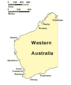
The Nullarbor Plain is a dry, riverless plateau in the south-east which runs along the border of South Australia. The name comes from a Latin word meaning 'without trees'. The 200 millimetres of rain that fall here quickly soak through the limestone rocks. Only a few bushes grow in the plains. The most productive area is the coastal margin from Esperance to Geraldton.
Western Australia Primary industries are varied depending on the climate and regions of the state. Agriculture is Western Australia's second biggest industry. Wheat, wool, beef and lamb are its main products. Fisheries and forest industry are another 2 industries. The mining and energy resources of Western Australia ensure that the state will be an important source of energy well into the next century

Webmasters: Click Here to make Cash! |
