 Iceland
Iceland
IcelandOctober 2006
When I discovered that British Airways were running cheap flights to Iceland for the last week of October (college half term), it seemed a crime not to jump at the chance to bag country 102 and get a further taster of Scandinavia which I had toured in the summer. Once I had booked a five day return flight, Lori, my girlfriend decided she’d like to come too and then so did her mum. I’d never been on holiday with a girlfriend’s mother before.
Iceland has a ferocious reputation for being the most expensive country in Europe (I’d read tales about a pint of beer costing Ł7 and a litre of petrol costing £3) but having the internet allowed me to trawl through accommodation possibilities and the Fosshotel group Foss Hotels have quite a few hotels which have deals. At the Baron Fosshotel in Reykjavik, we had the choice of having two separate rooms or for a few more English pounds, an apartment with two bedrooms and a kitchen which would allow us to save on the expensive eating out. Over four nights, this worked out at around £100 each which was as cheap as Bed & Breakfast in the UK and we could partake in an all-you-can-eat breakfast buffet every morning. Most tourists jump on expensive tours to see Iceland, but I found that Avis would rent us a car for around £120 for our stay which again was no more expensive than Europe. It gave us total flexibility and was far cheaper than the tour buses.
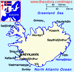
I had had Iceland on my top ten list to visit for some time, mostly for a walking holiday, but this first visit would be a useful introduction to the youngest country in Europe (physically it is only 20 million years old). Just bigger than Ireland, (350 km from N-S, 540km E-W), it lies across the vast undersea split known as the Mid-Atlantic Ridge, where two of the great plates of the earth’s surface are pulling apart.
“Nowhere on earth are the forces of nature are more evident than here, where glaciers, hot springs, geysers, active volcanoes, icecaps, tundra, snow-capped peaks, vast lava deserts, and waterfalls vie for the visitor’s attention” (Lonely Person’s guide)
We flew into Keflavik airport on Wednesday 24th October from Gatwick with our suitcases full of food and hand luggage lugging duty free rum. It was a small airport built on the flat lava Reykjanes peninsula. We picked up a Toyota Yaris car from Avis and by 11am, left the airport past ‘interesting’ modern sculptures (see photos) and took off on the empty roads, for a mystery tour around the south coast. Heading south, we passed the famous ‘Blue Lagoon’ which from a distance, looked like vast clouds of steam emanating from thick black crinkly lava next to a power station. We’d return here later on our trip.
Grindavik on the south coast of the peninsula was a fishing town of 2000 people. There is a new ‘Salt Herring’ Museum there. Leaving civilisation, the sealed road turned into just a dusty, virtually deserted, volcanic trail. The road wound over the back of Festarfjall’s volcanic core and then twisted down again to run parallel to the coast along the base of a rugged, boulder-strewn range. We only saw three cars over the next half hour. The landscape was surprisingly beautiful with the blue sea water to our right and buckled cliffs of purple potash rich rocks to the left. It is difficult to describe this area of Iceland which few tourists ever bother with. The Rough Guide said the peninsula had a “rough, rubbly south coast…comprising of a rift system and associated formations running due east of Grindavik. Much of the low lying area here is covered in characteristically dire lava-fields, rising to equally denuded ridges and peaks”
It was as if nature, on various occasions had just dumped all the rocks it didn’t need. The original lava flows have been covered in further eruptions. There are black volcanic mountains with dry sandy shallows in-between and huge cliffs where the lava finally stopped and froze against the seawater which have since been eroded by the sea or wind. The vegetation was mostly just tuft grass growing over the top of the lava like a thin green coating or bushes of autumnal golden bracken blowing in the wind.
Wind is one thing that Iceland has in abundance and the Avis rep had warned us to watch out when opening doors. He wasn’t kidding. On a couple of occasions, I opened the door and it was nearly blown off its hinges by the passing gusts.
The one thing that breaks up the barrenness of the Icelandic scenery are the herds Icelandic horses which dot the landscape in their thousands. They are a unique breed descended from medieval Norwegian stock, since none have been imported since the tenth century. If a horse leaves Iceland (to attend a show or whatever), it is never allowed back so that the breed remains pure and does not suffer from any horsy disease stuff. The horses (ponies really, since they are smaller than normal horses) are used to surviving in all weather conditions. Consequently, they have thick manes that cover their faces and long tails that nearly reach the ground and thick coats. They are beautiful animals, usually brown, sometimes white and brown or black and we never tired of seeing them everywhere.
We headed north and inland to Hverageroi (pop 1766). Known as “Hot Springs Garden” it sits against the mountains in a valley bubbling with hot springs. Over 40% of Iceland’s greenhouse architecture exploits this geothermal heat. There are various ‘hothouses’ you can visit but we just peered through the glass for a look at the tomatoes growing.
Selfoss (“Barn Falls”) was just up the road and this became the town we would pass through endlessly during our stay – principally because you have to cross its suspension bridge to go anywhere in the south. Selfoss (pop 4466) is the largest town in southern Iceland. It lies on the banks of the Olfusa in the midst of Iceland’s richest farming district and has the largest dairy industry in the country. Near the bridge stood its distinctive church.
Just north of Selfoss lay the Keiro Crater right by the roadside. “Probably created 3,000 years ago, by a sudden gas explosion through the ground, leaving a neat, conical hill whose crater is 70m deep and the same distance across.” (Rough Guide). The bottom was flooded. It was so windy and cold, we decided to skip the walk around the rim.
We had entered the ‘Golden Circle’ tourist area of attractions. Visible from miles away as a pall of steam rising above the plains, Geysir’s “hot springs bubble out over a grassy slope at the foot of Bjarnfell, studded with circular pools atop grey, mineral-streaked mounds” (Rough Guide). The springs’ positions periodically change as geological seams crack open or close and the current vents are believed to have started in the 13th Century. And of course there are the Geysirs themselves.
The 70m tall ‘Geysir’ gave its name to geysers to all others around the world. Unfortunately and ironically, Geysir (the Gusher) stopped erupting a few years back. However, its smaller neighbour ‘Stokkur’ goes off every ten minutes or so, shooting boiling steam some 30m into the air. It is fascinating to watch as the water in the circular pool at its base, is sucked in and out by the pressure of the hot geothermal water and cold water river water down below. When the pool is almost full, the water at the centre suddenly bubbles up in a luminous blue swell and the plume of steam erupts with a great hiss. The air is heavy with sulphur, the ground smokes and water streaks high into the air. We never got bored of watching the geysir gradually build into a bubble and finally erupt.
Further up the road, Gullfoss – ‘golden waterfall’ lies on the river Hvita and is one of the most famous sights in Iceland. There is a two kilometre canyon sided in organ-pipe basalt columns which is up to 70m deep. Gullfoss is actually two thundering falls, one immediately above the other and at right angles to it. Today, in the freezing cold, the path was iced over so we used ropes to get down and the entire area was covered in snow. The result was the marvellous sight of what looked like a massive frozen waterfall covered in ice with the spray rising in the air. See my photos to see what I mean.
With darkness looming, we headed back across the plains to Reykjavik and had a lovely sunset to accompany our western direction. We arrived in the capital city around rush hour in darkness, but negotiated the roads and managed to find our hotel in the centre of town with no problems.
At the Baron Fosshotel, we were allocated a two bedroom apartment with lounge/kitchen and bathroom. It was fully equipped (or at least it was by the time we went to reception and asked for missing items) and the TV even picked up BBC1. It was warm and comfortable and we could live on all the food we had brought with us. On Day 1 we soon discovered a couple of surprises. Firstly, petrol was about the same price as in England and secondly, there was a series of supermarkets called ‘Bonus’ which sold the cheap ‘Euroshopper’ food brands that we had seen in the rest of Scandinavia in the summer. As it was, we only had to buy bread and milk.
That evening, Lori and I had a stroll around the neighbourhood. We were just off the main shopping/restaurant strip called Laugavegur. We walked up a hill to see the fabulous looking Hallgrimskirkja which was lit like a beacon at night and down to Tjornin (the pond) in the centre with its bridge of many changing colours. Reykjavik was a beautiful city at night but it was hardly jumping around 9pm. I will cover the Reykjavik sights later.
The following morning while enjoying an extensive breakfast, we discovered just how many people were staying at the hotel. There seemed to be a lot of English tour groups. It was raining but we had the car and decided to stick to our itinerary. Today, we would do a 600 km road trip north of the capital via Hvalfjordur and Borgarnes onto and around the Western Snaefellsnes peninsula. At the garage near the hotel, I was amazed to see that someone would still fill your petrol tank while you went to the cashier. At another later in the trip, it was the usual self service, pay by credit card we had used in Norway and Sweden.
Hvalfjordur (Whale Fjord) was a long and beautiful fjord. We could have paid 1000Kr and taken the new tunnel to save 60 km driving around the Fjord, but opted for the tunnel on the way home. There were no whales in the Fjord for two reasons. Firstly, it was the wrong season, and secondly, Iceland had recently decided to break International agreements and start whale hunting again. We passed volcanic mountain ranges covered in snow, as if God had taken a giant sifter and sifted icing sugar over the peaks. Small waterfalls and rapids also broke up the gloomy scenery today.
Borgarnes is the only Icelandic coastal town that isn’t dependent upon fishing. Strung out along a narrow peninsula, the weather punishes it from all directions and today was no exception. While we were parked having a cup of tea from our flask, the wind and rain buffeted the car. We discovered that supermarkets didn’t open until at least 11.30am.
Jutting into the Atlantic Ocean, the 100 km Snaefellsnes Peninsula “a rugged yet beautiful arm of the Icelandic west coast” (Rough Guide) is characterised by a string of majestic mountains rising between a broad coastal plain on the south coast and a narrower one in the north. They run down the spine of the peninsula culminating in one of Iceland’s best known landmarks - the 1446m dormant volcano Snaefell with its icecap, the glacier Snaefellsjokull. Most of the inhabitants occupy the strip along the sheltered north coast. The sparse south coast population is dispersed on scattered farms where all rain seems to fall.
Today, the glacier was invisible behind the low rain clouds but there was plenty of lovely scenery to see along the way including the start of the Kerlingarskard pass which had a marvellous view back down over the southern plain. The villages were few and far between. We came across the two lofty rock pillars by the coast at Londrangar. The taller of the tall is 75m high and the other not that much shorter. They are the remnants of a basalt cinder cone.
Along the western edge, it was pretty cut off from civilisation. Just a windswept series of lava fields, wilderness and empty potholed roads. The fishing town of Olafsvik finally appeared but with no whale watching tours to run, it seemed empty of life. It did have a weird looking church with so many straight lines and triangles that it looked as if it has been designed by someone with a trigonometry fetish. We crossed another lava field to Grundarjordour, located by a lovely fjord and wiggled our way around the coast and up to a small peninsula to the village of Stykkisholmur.
The first thing that strikes you about picturesque Stykkisholmur (pop 1230) are the brightly coloured harbour-side buildings with different coloured roofs. The second thing is its 1990 church which sits on a rocky knoll overlooking the village and looks like a boat to me, a rocket to other people. Whatever. It is a church design you will not see anywhere else including a vast white ladder-like bell tower rearing up over the doorway and a semicircular domed rear roof. The interior is equally unusual, with hundreds of light bulbs suspended from the ceiling.
It had taken an age to drive around the peninsula and we still hadn’t reached the northern end. Despite the state of the roads, slow going and distance already covered, we decided to keep going a little further east to the impressive Alftafjordur (a Fjord) but looking at the gravel road, I made an executive decision to turn around and head south by crossing the Kerlingarskard pass which had an excellent sealed road and lovely scenery.
It was a race against darkness again. The rain was back with a vengeance. We reached the 1998 Hvalfjorour tunnel, 6 km long of which 4 km lie below the seabed and reduced the 108 km journey from Arkranes to Reykjavik to 49 km. It was good to get back to a warm hotel after a long day’s driving.
No rest for the wicked. We were up at 5am the following morning and off before 6am for an epic drive around the south coast. It was still raining and as we left the capital on Route 1 in the dark and headed over the hills, the rain turned to sleet and snowploughs were out on the roads to ensure that commuter traffic would get through.
We passed various flat, lichen-covered lava flows, with old volcanoes to either side (which we would see on the way back since it was dark in the morning). It then twisted off the ranges to the coastal plains into Hverageroi, 45 km from the capital, which we had visited on the first day. The glasshouses were luminous orange in the dark with the artificial light to keep the plants growing.
Back across Selfoss’s bridge and down to Skogar where it started to get light just before 9am. We passed the turn off to Dyrholaey (Iceland’s most southerly tip) where a colony of puffins hang out in the right season, but it was pissing down or should that be ‘persistently raining’ and there was no way that we were going to go walking along the black, basaltic coastline in that weather on the off chance that puffins had stuck around just for us. So we wound our way up and around some old volcanoes and headed down to Vik by the coast. To our left was the Myrdalsjokull glacier (fourth biggest icecap in Iceland) but it was hidden by the low cloud. Underneath the ice was a 1300m volcano called Katla which last erupted in 1918 and is due another eruption sooner rather than later.
Vik (pop 300) averages the highest rainfall in Iceland (tell me about it!) and is apparently a “pleasant coastal village” without a harbour (Rough Guide). Well it would have been pleasant in some sunshine. We drove right through and it was like driving through a car wash. I had been driving in heavy rain for three hours by now.
East of Vik, the ancient boulder shaped lava flows were covered in a thick spongy green moss. It gave the scenery a strange greenish glow. It looked like the area was suffering from severe dampness (which, today, it was) where a green fungus had crept over the landscape. We came across a small hillock both covered and surrounded by small rocky cairns. I can’t remember why, but it was something to do with an 18th century farmhouse being here when the local volcano erupted.
I later read that that volcano is called Lakagigar and was the cause of the most catastrophic volcanic event in Iceland’s recorded history. In June 1783 “the earth split into a 25 km long fissure that over the next seven months, poured out a continuous thick blanket of poisonous ash and smoke and enough lava to cover 600 sq km…there were no harvests that year in Iceland and livestock dropped dead due to the poisoned grass. Over the next three years, Iceland’s population plummeted by a quarter – through starvation, earthquakes and an outbreak of smallpox – to just 38,000 people at which point the Danish government considered evacuating the survivors” (Rough Guide). No wonder they come to build cairns here.
The Rough Guide calls the area that Route 1 passes through here “dismal” and “eventless” but we found the scenery strangely intriguing. On our left were the old snow capped volcanoes and sporadic waterfalls tumbling over the cliffs and to either side was the ‘green fungus’.
What I had not anticipated was the strength of the wind which we were driving into. In this dreadful weather, the road was virtually deserted but when the wind literally pushed the car off to the side, I had to consider my options. I decided to slow down and drive in the centre of the two lane highway. On at least half a dozen occasions, gusts of winds would push the car off the direction I was steering it - which freaked me out. What happens if it blows us over? The Yaris is not exactly heavy (even with my weight). The heart stopping episodes were when cars came from the opposite direction with the wind behind them. A gust of wind could have caused us to crash into each other.
As we approached the 1700 sq km Skaftafell National Park, the scenery turned into three deeply crevassed glaciers, with Skaftafellsjokull flanked by Morsarjokull to the left and Svinafellsjokull to the right, and a forth, Skeidararjokull, much broader and flatter in appearance over to our left. They are tributaries of the great ice caps of Vatnajokull and Oraefajokull. Skaftafellsjokull was chosen by Jules Verne as the start for his epic “Journey to the Centre of the Earth”.
The rain was taking a break and the wind had calmed. We parked at the Visitor’s Centre and walked for a kilometre to the gigantic edge of the Skaftafellsjokull glacier and climbed up onto the ice. There was noone else around and it was nice to have another glacier to ourselves just as we had in Norway. It would be lovely to come back in the summer months and go hiking around this area. Maybe one day.
Below Skaftafellsjokull, the green fungus gave way to the flatness of braided black volcanic gravel plains split by meandering flows of glacial water heading for the coast. There are a series of bridges to skirt these ever changing glacial rivers but nothing is certain. In 1996, an earthquake (‘jokulhlaup’) triggered off the Grimsvotn volcano which erupted and melted its covering icecap (Vatnajokull). The resulting rivers washed away the entire road and all the bridges for miles. They have rebuilt it, but the engineers are still trying to work out how to survive a similar episode by building manmade barriers to channel the water.
“After the monotony of the surrounding landscape and the coal black of the ‘sandur’ (glacial gravel) shore, the luminous beauty of the iceberg at Jokulsarlon always surprises” (AA Essential Iceland). Jokulsarlon – “Glacial River Lagoon” was less than a thirty minute drive east and took us by surprise. Even today, on a rainy day, the compressed ancient turquoise ice, humbug-striped with black glacial moraine, seemed to be lit from within as the bergs move slowly around the lake. They have broken away from the great Breioamerkurjokull glacier which looms up behind.
It has grown and retreated over the years, gorging a lake 190m deep with icy waters that pour into the sea. One day, the lake will break through the glacial moraine. This lake was used for scenes for the James Bond movie ‘A View to a Kill’. We had a late lunch while the car was buffeted by the wind and returning rain. Lori and her mother were adamant that this was the finest sight they saw in Iceland (apart from the ‘Skokkar’ Geysir). We had expected to find lots of tour buses here but I guess the weather put them off. There were only two other cars who showed up to have a look.
It was 2.30pm and time to turn around. We had driven 350 km to see this sight. The trip back was another five hour epic haul with the wind behind us. At the edge of the lake on the way back, we took a gravel road off to the side and drove up to the lakeside with the immense Breioamerkurjokull glacier just across the water. Chunks of ice had washed up on the shore like huge diamonds. The rest of the return trip is a repetitive blur apart from stopping at the wonderful Skogar waterfall just before dusk which we had missed on the way and a petrol stop at Vik, where it was still raining.
Top Tip: In Iceland, you will see virtually no public toilets, but every garage has toilets. Garages can be few and far between in some areas so it is worth filling up whenever you have the chance after you are half empty.
It was dark by the time we returned to Hverageroi, where the glasshouses were still a luminous orange in the dark. It was as if we had been in a time-warp. Over the hills and back to Reykjavik. 700 km after leaving the hotel at 6am, we returned 14 hours later and not surprisingly, had a lazy evening.
Saturday morning. It had finally stopped raining and the sun had returned. We had one final sight from the ‘Golden Circle’ tour - Pingvellir – (pronounced Thingvellir). The great fault line at Thingvellir, where the geological plates of America and Europe which are slowly tearing apart, provided a remarkable natural arena for the gatherings of freeman, chieftains and bishops to discuss matters of law and justice, crime and punishment. The first Althing, or parliament, was held here in AD930 and they continued annually until 1789, when the plain fell 1m in an earthquake and the power base shifted to Reykjavik. Birch and willow grow amid the fissured rocks of the plain, with the lake to the south and low mountains in the distance, and the eye is drawn to the 19th-century church and the white-gabled farmhouse beside it.
It was raining by the time we reached the Visitor’s Centre, but the tour buses had arrived en mass. We had an enjoyable stroll around the area where informative signs told us what we were seeing. I hadn’t expected much from Pingvellir, but I now understand why everyone comes to see it. It is a beautiful area, dripping with history but still tamed by nature.
While we were in the vicinity, we made a detour back to Geysir along a snowbound lane that tested the car. Locals rushed past in their four wheel drives honking horns as if to say, what the hell are you doing here with that piece of crap? At Geysir, the wind had dropped and it looked like a different place to when we had seen it three days ago. The tourists were also thicker in number but we still enjoyed the ambience of the area. On the way back to Reykjavik, we saw a large herd of Icelandic horses in a snow covered field and naturally had to stop for photo and petting opportunities. This herd had fouls. Back in Reykjavik, we parked up at the hotel and did a walking tour amongst the Saturday afternoon shoppers.
The city was settled in 877AD when a Norwegian Viking Injolfur Amarson heaved his chair overboard and said he would settle wherever they washed up. They turned up in an inlet seemingly full of smoke and it was called ‘smoky inlet’ or Reykavik. When they landed, they discovered the smoke was caused by the hot springs. Geothermal energy still keeps the city in everything from hot water to electricity.
Reykavijk is still the world’s northernmost capital city and home to 62% of Iceland’s 280,000 people (1806 – 300 inhabitants of which 27 were in prison for being pissed). It has a picturesque setting by the coast and even in downtown Reykjavik, crisp snow capped mountains could be seen close by across the harbour.
Amongst the shopping expedition (well what do you expect from a mother and daughter), we took in the wonderful Hallgrimskirkja which we had only seen at night. Completed in 1986, the church took 49 years to build. White rockets come to mind when you see the church from a distance. Close up, its concrete pillars resemble giant hexagonal volcanic columns, or even organ pipes. Step through the door and it’s like entering a towering ice-cathedral. The organ has 5,275 pipes. The 73m high tower dominates the skyline. The church can hold 1200 people.
I wanted to visit the Iceland Phallogical Museum – “The only penis museum in the world, proudly exhibiting members belonging to nearly all the mammals in Iceland, including a human foreskin. There are 15 different whale specimens, all neatly organised and stored in jars, one over 6ft tall” (Footprint Guide to Reykjavik). Unfortunately it had closed. The subject matter had obviously not drawn the crowds. I thought it was a brilliant idea.
Instead, we walked on past old state buildings, and the unremarkable wooden cathedral built in 1847 to Tjornin – a pond in the centre full of birds offering good views of the old houses around it and the terrible concrete architecture of the 1992 City Hall, redeemed only because of its reflection on the lake. Somewhere in the streets, we think we found the Parliament building but nothing was marked and there were no security guards and we never exactly discovered the actual building.
Before we knew it, the lovely Saturday afternoon sun had descended into darkness. After a meal, Lori and I headed to the local baths on the same road as the hotel and took advantage of the hot baths which lay outside the swimming pool under the stars. It only cost £2 each but we had less than an hour to enjoy two pools. One was a comfortable 38’c with in built Jacuzzi water blowers. The other was 41’c. Both were filled with teenagers/students especially loud American students who felt the need to let the rest of the world know their life stories.
Later on, we did a driving tour of Reykjavik by night. The highlight was Perlan (The Pearl) - surrounded by pine trees, it is what “James Bond’s secret islandic headquarters should look like” (Footprint). A massive space-age edifice squatted on Oskjuhlid, to the south of town. Its great towers hold 24 million litres of geothermally heated water – enough to service half the city. Between them is an exhibition space on different levels, with a café, and a mini-geyser which shoots up from the basement. There is a revolving restaurant at the top. The view over the city at night was brilliant. Recommended at night.
The three long days of driving had caught up with me and I wanted to crash. Lori wanted to head for the hills on the off chance that we would see the ‘Northern Lights’. Iceland is in the middle of the auroral zone where the northern lights, bands of colour that sweep across the sky, are most frequently seen. If the sky is dark enough and night is clear, you should be able to see them. “They are caused by electrically charged particles emitted by the sun reacting with the sun reacting with the earth’s magnetic field. Some electrons are drawn towards the earth, centring on the north and south poles. These reactions happen at great speed and cause the air to glow in beautiful green and pink colours.” (Footprint). Since I was driving, I had the upper hand and we headed for home. The next day, we met a couple who saw the Northern Lights that night. Boy, did I get an earful for the decision not to bother. What do you do? At that point, I had driven around 2000km in 3 days and I was tired. So shoot me.
We made the most of the final breakfast at the hotel and had a leisurely drive in the sunshine to the airport just outside Keflavik. We checked in the car and arrived at the check in desk where there was nobody queuing. There were 90 minutes before departure. After handing over our passports and ticket reference number, we were told to wait. The British Airways Operations Manager called Peter finally arrived and explained that there had been some double booking. There were only two seats left in Business Class. This was no use to us. Even if Lori and her mum flew home, I was the driver. We offered to take a ‘bucket seat’ but could not for ‘security reasons’.
Peter was very apologetic and embarrassed. “This is the first time that it has happened in six months here”. He couldn’t work out how it had happened. There were two Icelandic Airline flights to London Airports (not Gatwick) but they were both full. Essentially we were stranded until the next British Airways flight the following day. We were automatically upgraded to Club Class and then asked what we needed. We needed a phone to contact the UK since all three of us were due back at work tomorrow. Peter gave us his mobile phone and we made the relevant calls. Then he booked us into the ‘Keflavik Hotel’ and said we could charge an evening meal to BA. All things considered he couldn’t have been more helpful. I went back to Avis and got the car back for an extra day and we drove to nearby Keflavik to dump our luggage at the best hotel in Keflavik. We had a double and single room with breakfast thrown in. The rooms were worth £200 alone. Keflavik – 48km west of Reykjavik is a trading centre and fishing port along with supplying the International airport.
With a spare afternoon, we first headed to the nearby coast. En route just outside Keflavik, we came across a couple of old traditional wooden houses with turf roofs and a full scale replica of a Viking ship that would have been used to sail to Iceland from Norway. The coastline at Garour was nothing special so we cut our losses and headed for the Blue Lagoon. It had been the one major site that we had not had time to visit.
The ‘Blue Lagoon’ contains a vast amount of geothermally heated sea-water (36’c – 39’c), rich in natural minerals. It is the natural by-product of the nearby Svartsengi power station which uses water straight from 2000m below the ground which is at a much higher temperature. The locals nickname the Blue Lagoon as the “Chemical waste dump”. Its opacity comes from the natural white silica mud mixed with minerals and algae, which gives it a milky blue colour.
Since it was a Sunday afternoon, it was mostly full of locals and tourist couples. Yet, with the size of the lagoon, there was tons of room and you didn’t feel crowded. After changing in wooden dressing rooms, we descended and entered the water which was a pleasant ‘warm bath’ temperature. You could walk around at waist height. There were barrels full of silica mud which you could smear over your face for exfoliation. In one section was a natural geyser which spouted boiling water for 15 minutes at various intervals. The water is naturally replaced every 48 hours. Needless to say, we had a lazy two hours soaking and pottering around the lagoon and felt very relaxed.
Back at the hotel, we opted to use the Chinese restaurant within the hotel. This meant we could charge the meal to the room bill and not have to bother trying to reclaim expenses from British Airways. We had a delicious meal, with Icelandic fish done in Chinese style and I got to try some Icelandic beer (not brilliant). I was amazed that despite the fact that we had been conservative on our order (starter, main course, no dessert, coffee, glass of wine, 2 large beers), the bill came to £99! I was glad that we had bought all our food with us to cut down on the costs.
After the meal, Lori insisted on going to see the ‘Northern Lights’ so I drove us back down towards the Blue Lagoon where there are few lights. We waited an hour in the dark and nothing appeared. Then I drove us back with a whining girlfriend “if only we had gone out last night etc etc”. You do your best. If you predict the ‘Northern Lights’ you’d make a fortune.
The breakfast buffet the following morning included smoked salmon toasties. Yum yum. I attempted to try everything available but gave up half way through. After leaving the hotel with the order to let Peter sort out the bill, we had a déjŕ vu return trip to the airport (except it was about 10km rather than 45km) and returned the car. I paid for the extra day. We figured British Airways had done enough to compensate and it was more flexible than their original offer of a taxi ride to and from the hotel where we would have been stuck all day. Interestingly Avis don’t charge you for lost hubcaps. Not that we lost one.
After checking in, we headed for the Club Class lounge airside which had newspapers, laptops with internet connections, snacks, coffee, beer, wine etc etc. I made the most of the free Iceland beer and internet. Club class is such a civilised way to travel don’t you know? I’d only experienced it a couple of times before. We boarded the plane and got the spacious seats at the front along with an excellent lamb lunch and bottles of champagne. I could get used to this.
My final observations about Iceland: The scenery is superb. We saw it as the start of winter arrived with the snow capped mountains but it must look nice in the spring and summer. The scenery has to be spectacular because the towns/villages are nothing special although Reykjavik is a pleasant relaxed capital. We didn’t find the Icelandic people particularly friendly – what I’d call utilitarian Scandinavian – they do what they are supposed to do but they won’t make small talk if they could avoid it.
If you can get an apartment and take your food and duty free with you, you will really cut down on expenses – eating out and drinking booze seemed a killer on the credit card. There are ‘Bonus’ supermarkets where you can get cheap foodstuffs. Renting a car is a major advantage. You avoid the expensive tours and have total flexibility. However, do not under estimate how long it takes you to get around and going in October meant that we were reduced to nine hours of daylight a day. Petrol is no more expensive than Europe. On my next visit, I intend to drive right around the island and do some hiking. The island definitely justifies a second visit. Wait for the cheap offers to do it. Recommended.